1996 Edition
CIA World Factbook 1996 (Project Gutenberg)
Introduction
Description
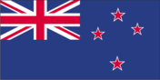
blue with the flag of the UK in the upper hoist-side quadrant with four red five-pointed stars edged in white centered in the outer half of the flag; the stars represent the Southern Cross constellation
Location
41 00 S, 174 00 E -- Oceania, islands in the South Pacific Ocean, southeast of Australia Flag ----
Geography
Area
- comparative area
- about the size of Colorado
- land area
- 268,670 sq km
- note
- includes Antipodes Islands, Auckland Islands, Bounty Islands, Campbell Island, Chatham Islands, and Kermadec Islands
- total area
- 268,680 sq km
Climate
temperate with sharp regional contrasts
Coastline
15,134 km
Environment
- current issues
- deforestation; soil erosion; native flora and fauna hard-hit by species introduced from outside
- international agreements
- party to - Antarctic-Environmental Protocol, Antarctic Treaty, Biodiversity, Climate Change, Endangered Species, Environmental Modification, Hazardous Wastes, Marine Dumping, Nuclear Test Ban, Ozone Layer Protection, Tropical Timber 83, Wetlands, Whaling; signed, but not ratified - Law of the Sea, Marine Life Conservation, Tropical Timber 94
- natural hazards
- earthquakes are common, though usually not severe; volcanic activity
Geographic coordinates
41 00 S, 174 00 E
Geographic note
about 80% of the population lives in cities
International disputes
territorial claim in Antarctica (Ross Dependency)
Irrigated land
2,800 sq km (1989 est.)
Land boundaries
0 km
Land use
- arable land
- 2%
- forest and woodland
- 38%
- meadows and pastures
- 53%
- other
- 7%
- permanent crops
- 0%
Location
Oceania, islands in the South Pacific Ocean, southeast of Australia
Map references
Oceania
Maritime claims
- continental shelf
- 200 nm or to the edge of the continental margin
- exclusive economic zone
- 200 nm
- territorial sea
- 12 nm
Natural resources
natural gas, iron ore, sand, coal, timber, hydropower, gold, limestone
Terrain
- predominately mountainous with some large coastal plains
- highest point
- Mount Cook 3,764 m
- lowest point
- Pacific Ocean 0 m
People and Society
Age structure
0-14 years: 23% (male 420,900; female 400,159) 15-64 years: 65% (male 1,161,522; female 1,154,536) 65 years and over: 12% (male 177,182; female 233,684) (July 1996 est.)
Birth rate
15.78 births/1,000 population (1996 est.)
Death rate
7.72 deaths/1,000 population (1996 est.)
Ethnic divisions
European 88%, Maori 8.9%, Pacific Islander 2.9%, other 0.2%
Infant mortality rate
6.7 deaths/1,000 live births (1996 est.)
Languages
English (official), Maori
Life expectancy at birth
- female
- 80.21 years (1996 est.)
- male
- 73.96 years
- total population
- 77.01 years
Literacy
- age 15 and over can read and write (1980 est.)
- total population
- 99%
Nationality
- adjective
- New Zealand
- noun
- New Zealander(s)
Net migration rate
3.17 migrant(s)/1,000 population (1996 est.)
Population
3,547,983 (July 1996 est.)
Population growth rate
1.12% (1996 est.)
Religions
Anglican 24%, Presbyterian 18%, Roman Catholic 15%, Methodist 5%, Baptist 2%, other Protestant 3%, unspecified or none 33% (1986)
Sex ratio
- all ages
- 0.98 male(s)/female (1996 est.)
- at birth
- 1.05 male(s)/female
- under 15 years
- 1.05 male(s)/female 15-64 years: 1.01 male(s)/female 65 years and over: 0.76 male(s)/female
Total fertility rate
2.01 children born/woman (1996 est.)
Government
Administrative divisions
- 93 counties, 9 districts*, and 3 town districts**; Akaroa, Amuri, Ashburton, Bay of Islands, Bruce, Buller, Chatham Islands, Cheviot, Clifton, Clutha, Cook, Dannevirke, Egmont, Eketahuna, Ellesmere, Eltham, Eyre, Featherston, Franklin, Golden Bay, Great Barrier Island, Grey, Hauraki Plains, Hawera*, Hawke's Bay, Heathcote, Hikurangi**, Hobson, Hokianga, Horowhenua, Hurunui, Hutt, Inangahua, Inglewood, Kaikoura, Kairanga, Kiwitea, Lake, Mackenzie, Malvern, Manaia**, Manawatu, Mangonui, Maniototo, Marlborough, Masterton, Matamata, Mount Herbert, Ohinemuri, Opotiki, Oroua, Otamatea, Otorohanga*, Oxford, Pahiatua, Paparua, Patea, Piako, Pohangina, Raglan, Rangiora*, Rangitikei, Rodney, Rotorua*, Runanga, Saint Kilda, Silverpeaks, Southland, Stewart Island, Stratford, Strathallan, Taranaki, Taumarunui, Taupo, Tauranga, Thames-Coromandel*, Tuapeka, Vincent, Waiapu, Waiheke, Waihemo, Waikato, Waikohu, Waimairi, Waimarino, Waimate, Waimate West, Waimea, Waipa, Waipawa*, Waipukurau*, Wairarapa South, Wairewa, Wairoa, Waitaki, Waitomo*, Waitotara, Wallace, Wanganui, Waverley**, Westland, Whakatane*, Whangarei, Whangaroa, Woodville
- note
- there may be a new administrative structure of 16 regions (Auckland, Bay of Plenty, Canterbury, Gisborne, Hawke's Bay, Marlborough, Nelson, Northland, Otago, Southland, Taranaki, Tasman, Waikato, Wanganui-Manawatu, Wellington, West Coast) that are subdivided into 57 districts and 16 cities* (Ashburton, Auckland*, Banks Peninsula, Buller, Carterton, Central Hawke's Bay, Central Otago, Christchurch*, Clutha, Dunedin*, Far North, Franklin, Gisborne, Gore, Grey, Hamilton*, Hastings, Hauraki, Horowhenua, Hurunui, Hutt*, Invercargill*, Kaikoura, Kaipara, Kapiti Coast, Kawerau, Mackenzie, Manawatu, Manukau*, Marlborough, Masterton, Matamata Piako, Napier*, Nelson*, New Plymouth, North Shore*, Opotiki, Otorohanga, Palmerston North*, Papakura*, Porirua*, Queenstown Lakes, Rangitikei, Rodney, Rotorua, Ruapehu, Selwyn, Southland, South Taranaki, South Waikato, South Wairarapa, Stratford, Tararua, Tasman, Taupo, Tauranga, Thames Coromandel, Timaru, Upper Hutt*, Waikato, Waimakariri, Waimate, Waipa, Wairoa, Waitakere*, Waitaki, Waitomo, Wanganui, Wellington*, Western Bay of Plenty, Westland, Whakatane, Whangarei)
Capital
Wellington
Constitution
no formal, written constitution; consists of various documents, including certain acts of the UK and New Zealand Parliaments; Constitution Act 1986 was to have come into force 1 January 1987, but has not been enacted
Data code
NZ
Dependent areas
Cook Islands, Niue, Tokelau
Diplomatic representation in US
- chancery
- 37 Observatory Circle NW, Washington, DC 20008
- chief of mission
- Ambassador Lionel John WOOD
- consulate(s) general
- Apia (Western Samoa), Los Angeles
- telephone
- [1] (202) 328-4800
Executive branch
- cabinet
- Executive Council was appointed by the governor general on the recommendation of the prime minister
- chief of state
- Queen ELIZABETH II (since 6 February 1952) is a hereditary monarch, represented by Governor General Sir Michael HARDIE BOYS (since 21 March 1996)
- head of government
- Prime Minister James BOLGER (since 29 October 1990) and Deputy Prime Minister Donald McKINNON (since 2 November 1990) were appointed by the governor general
FAX
- [64] (4) 472-3537
- consulate(s) general
- Auckland
Flag
blue with the flag of the UK in the upper hoist-side quadrant with four red five-pointed stars edged in white centered in the outer half of the flag; the stars represent the Southern Cross constellation
House of Representatives (commonly called Parliament)
elections last held 6 November 1993 (next must be called by November 1996); results - NP 35.2%, NZLP 34.7%, Alliance 18.3%, New Zealand First 8.3%; seats - (99 total) NP 50, NZLP 45, Alliance 2, New Zealand First Party 2
Independence
26 September 1907 (from UK)
International organization participation
ANZUS (US suspended security obligations to NZ on 11 August 1986), APEC, AsDB, Australia Group, C, CCC, CP, EBRD, ESCAP, FAO, IAEA, IBRD, ICAO, ICFTU, ICRM, IDA, IEA, IFAD, IFC, IFRCS, ILO, IMF, IMO, Inmarsat, Intelsat, Interpol, IOC, IOM (observer), ISO, ITU, MTCR, NAM (guest), OECD, PCA, Sparteca, SPC, SPF, UN, UNAVEM III, UNCTAD, UNESCO, UNIDO, UNPREDEP, UNPROFOR, UNTSO, UPU, WFTU, WHO, WIPO, WMO, WTrO
Judicial branch
High Court; Court of Appeal
Legal system
based on English law, with special land legislation and land courts for Maoris; accepts compulsory ICJ jurisdiction, with reservations
Legislative branch
unicameral
Name of country
- abbreviation
- NZ
- conventional long form
- none
- conventional short form
- New Zealand
National holiday
Waitangi Day, 6 February (1840) (Treaty of Waitangi established British sovereignty)
Political parties and leaders
- National Party (NP, government), James BOLGER; New Zealand Labor Party (NZLP, opposition), Helen CLARK; Alliance, Jim ANDERTON; Democratic Party, Dick RYAN; New Zealand Liberal Party, Hanmish MACINTYRE and Gilbert MYLES; Green Party, no official leader; Mana Motuhake, Sandra LEE; Socialist Unity Party (SUP, pro-Soviet), leader NA; New Zealand First, Winston PETERS; United New Zealand (UNZ), Clive MATTHEWSON; Conservative Party (formerly Right of Centre Party), Trevor ROGERS; Association of Consumers and Taxpayers, New Zealand (ACT), Richard PREBBLE; Christian Democrats, Graeme LEE; Christian Heritage Party (CH), Rev. Graham CAPILL
- note
- the New Zealand Liberal, New Labor, Democratic, and Mana Motuhake parties formed a coalition called the Alliance Party in September 1991; the Green Party joined the coalition in May 1992; the National Party government formed a coalition with the United New Zealand Party in February 1996; the coalition will be valid through the 1996 elections
Suffrage
18 years of age; universal
Type of government
parliamentary democracy
US diplomatic representation
- chief of mission
- Ambassador Josiah Horton BEEMAN
- embassy
- 29 Fitzherbert Terrace, Thorndon, Wellington
- mailing address
- P. O. Box 1190, Wellington; PSC 467, Box 1, FPO AP 96531-1001
- telephone
- [64] (4) 472-2068
Economy
Agriculture
wheat, barley, potatoes, pulses, fruits, vegetables; wool, meat, dairy products; fish catch reached a record 503,000 metric tons in 1988
Budget
- expenditures
- $20.28 billion, including capital expenditures of $NA (FY95/96 est.)
- revenues
- $22.18 billion
Currency
1 New Zealand dollar (NZ$) = 100 cents
Economic aid
- donor
- ODA, $98 million (1993)
Economic overview
- Since 1984 the government has been reorienting an agrarian economy dependent on a guaranteed British market toward a more industrialized, open, free market economy that can compete on the global scene. The government has hoped that dynamic growth would boost real incomes, broaden and deepen the technological capabilities of the industrial sector, reduce inflationary pressures, and permit the expansion of welfare benefits. The initial
- results were mixed
- inflation is down from double-digit levels, but growth was sluggish in 1988-91. In 1992-93, growth picked up to 3% annually, a sign that the new economic approach was beginning to pay off. Business confidence strengthened in 1994, and export demand picked up in the Asia-Pacific region, resulting in 6.2% growth. Growth continued strong in 1995, and inflation remains among the lowest in the industrial world. The government announced its first budget surplus in 16 years in FY94/95 and forecasts a surplus of $5.0 billion in FY97/98. The government intends to use the surplus to reduce the debt, increase social spending, and cut taxes - by $1.35 billion over two years beginning in 1996. Per capita GDP now is up to the levels of the big West European economies.
Electricity
- capacity
- 7,520,000 kW
- consumption per capita
- 8,401 kWh (1993)
- production
- 30.5 billion kWh
Exchange rates
New Zealand dollars (NZ$) per US$1 - 1.5138 (January 1996), 1.5235 (1995), 1.6844 (1994), 1.8495 (1993), 1.8584 (1992), 1.7265 (1991)
Exports
- $13.41 billion (1995)
- commodities
- wool, lamb, mutton, beef, fish, cheese, chemicals, forestry products, fruits and vegetables, manufactures
- partners
- Australia 20%, Japan 15%, US 12%, UK 6%
External debt
$38.5 billion (September 1994)
Fiscal year
1 July - 30 June
GDP
purchasing power parity - $62.3 billion (1995 est.)
GDP composition by sector
- agriculture
- 7.3%
- industry
- 25.9%
- services
- 66.8% (1990)
GDP per capita
$18,300 (1995 est.)
GDP real growth rate
5.5% (1995 est.)
Imports
- $13.62 billion (1995)
- commodities
- machinery and equipment, vehicles and aircraft, petroleum, consumer goods
- partners
- Australia 21%, US 18%, Japan 16%, UK 6%
Industrial production growth rate
NA%
Industries
food processing, wood and paper products, textiles, machinery, transportation equipment, banking and insurance, tourism, mining
Inflation rate (consumer prices)
2% (FY95/96)
Labor force
- 1,634,500 (September 1995)
- by occupation
- services 64.6%, industry 25.0%, agriculture 10.4% (1994)
Unemployment rate
6.1% (October 1995)
Communications
Branches
New Zealand Army, Royal New Zealand Navy, Royal New Zealand Air Force
Defense expenditures
exchange rate conversion - $556 million, 1% of GDP (FY93/94)
Manpower availability
- males age 15-49
- 927,212
- males fit for military service
- 780,976
- males reach military age (20) annually
- 27,433 (1996 est.)
Radio broadcast stations
AM 64, FM 2, shortwave 0
Radios
3.215 million (1992 est.)
Telephone system
- excellent international and domestic systems
- domestic
- NA
- international
- submarine cables to Australia and Fiji; satellite earth stations - 2 Intelsat (Pacific Ocean)
Telephones
1.7 million (1986 est.)
Television broadcast stations
14 (1986 est.)
Televisions
1.53 million (1992 est.) Defense
Transportation
Airports
- total
- 113
- with paved runways 1 524 to 2 437 m
- 8
- with paved runways 914 to 1 523 m
- 31
- with paved runways over 3 047 m
- 2
- with paved runways under 914 m
- 50
- with unpaved runways 1 524 to 2 437 m
- 1
- with unpaved runways 914 to 1 523 m
- 21 (1995 est.)
Highways
- paved
- 54,142 km (including 141 km of expressways)
- total
- 93,348 km
- unpaved
- 39,206 km (1992 est.)
Merchant marine
- ships by type
- bulk 6, cargo 1, liquefied gas tanker 1, oil tanker 3, railcar carrier 1, roll-on/roll-off cargo 5 (1995 est.)
- total
- 17 ships (1,000 GRT or over) totaling 162,220 GRT/213,749 DWT
Pipelines
petroleum products 160 km; natural gas 1,000 km; condensate (liquefied petroleum gas - LPG) 150 km
Ports
Auckland, Christchurch, Dunedin, Tauranga, Wellington
Railways
- narrow gauge
- 3,973 km 1.067-m gauge (504 km electrified)
- total
- 3,973 km
Waterways
1,609 km; of little importance to transportation