2010 Edition
CIA World Factbook 2010 (Project Gutenberg)
Introduction
Background
South Africa occupied the German colony of South-West Africa during World War I and administered it as a mandate until after World War II, when it annexed the territory. In 1966 the Marxist South-West Africa People's Organization (SWAPO) guerrilla group launched a war of independence for the area that became Namibia, but it was not until 1988 that South Africa agreed to end its administration in accordance with a UN peace plan for the entire region. Namibia has been governed by SWAPO since the country won independence in 1990. Hifikepunye POHAMBA was elected president in November 2004 in a landslide victory replacing Sam NUJOMA who led the country during its first 14 years of self rule. POHAMBA was reelected in November 2009.
Geography
Area
- land
- 823,290 sq km
- total
- 824,292 sq km
- water
- 1,002 sq km
Area - comparative
slightly more than half the size of Alaska
Climate
desert; hot, dry; rainfall sparse and erratic
Coastline
1,572 km
Elevation extremes
- highest point
- Konigstein 2,606 m
- lowest point
- Atlantic Ocean 0 m
Environment - current issues
limited natural fresh water resources; desertification; wildlife poaching; land degradation has led to few conservation areas
Environment - international agreements
- party to
- Antarctic-Marine Living Resources, Biodiversity, Climate Change, Climate Change-Kyoto Protocol, Desertification, Endangered Species, Hazardous Wastes, Law of the Sea, Ozone Layer Protection, Wetlands signed, but not ratified: none of the selected agreements
Freshwater withdrawal (domestic/industrial/agricultural)
- per capita
- 148 cu m/yr (2000)
- total
- 0.3 cu km/yr (24%/5%/71%)
Geographic coordinates
22 00 S, 17 00 E
Geography - note
first country in the world to incorporate the protection of the environment into its constitution; some 14% of the land is protected, including virtually the entire Namib Desert coastal strip
Irrigated land
80 sq km (2003)
Land boundaries
- border countries
- Angola 1,376 km, Botswana 1,360 km, South Africa 967 km, Zambia 233 km
- total
- 3,936 km
Land use
- arable land
- 0.99%
- other
- 99% (2005)
- permanent crops
- 0.01%
Location
Southern Africa, bordering the South Atlantic Ocean, between Angola and South Africa
Map references
Africa
Maritime claims
- contiguous zone
- 24 nm
- exclusive economic zone
- 200 nm
- territorial sea
- 12 nm
Natural hazards
prolonged periods of drought
Natural resources
diamonds, copper, uranium, gold, silver, lead, tin, lithium, cadmium, tungsten, zinc, salt, hydropower, fish note: suspected deposits of oil, coal, and iron ore
Terrain
mostly high plateau; Namib Desert along coast; Kalahari Desert in east
Total renewable water resources
45.5 cu km (1991)
People and Society
Age structure
0-14 years: 35.9% (male 381,904/female 375,059) 15-64 years: 60.2% (male 641,995/female 627,146) 65 years and over: 3.9% (male 36,894/female 45,667) (2010 est.)
Birth rate
21.82 births/1,000 population (2010 est.)
Death rate
12.97 deaths/1,000 population (July 2010 est.)
Education expenditures
6.9% of GDP (2008)
Ethnic groups
black 87.5%, white 6%, mixed 6.5% note: about 50% of the population belong to the Ovambo tribe and 9% to the Kavangos tribe; other ethnic groups include Herero 7%, Damara 7%, Nama 5%, Caprivian 4%, Bushmen 3%, Baster 2%, Tswana 0.5%
HIV/AIDS - adult prevalence rate
15.3% (2007 est.)
HIV/AIDS - deaths
5,100 (2007 est.)
HIV/AIDS - people living with HIV/AIDS
200,000 (2007 est.)
Infant mortality rate
- female
- 42.05 deaths/1,000 live births (2010 est.)
- male
- 48.89 deaths/1,000 live births
- total
- 45.52 deaths/1,000 live births
Languages
English 7% (official), Afrikaans common language of most of the population and about 60% of the white population, German 32%, indigenous languages 1% (includes Oshivambo, Herero, Nama)
Life expectancy at birth
- female
- 51.64 years (2010 est.)
- male
- 52.25 years
- total population
- 51.95 years
Literacy
- definition: age 15 and over can read and write
- female
- 83.5% (2001 census)
- male
- 86.8%
- total population
- 85%
Major infectious diseases
- degree of risk
- high
- food or waterborne diseases
- bacterial diarrhea, hepatitis A, and typhoid fever
- vectorborne disease
- malaria
- water contact disease
- schistosomiasis (2009)
Median age
- female
- 21.4 years (2010 est.)
- male
- 21.3 years
- total
- 21.4 years
Nationality
- adjective
- Namibian
- noun
- Namibian(s)
Net migration rate
0.25 migrant(s)/1,000 population (2010 est.)
Population
2,128,471 note: estimates for this country explicitly take into account the effects of excess mortality due to AIDS; this can result in lower life expectancy, higher infant mortality, higher death rates, lower population growth rates, and changes in the distribution of population by age and sex than would otherwise be expected (July 2010 est.)
Population growth rate
0.909% (2010 est.)
Religions
Christian 80% to 90% (Lutheran 50% at least), indigenous beliefs 10% to 20%
School life expectancy (primary to tertiary education)
- female
- 12 years (2008)
- male
- 12 years
- total
- 12 years
Sex ratio
- at birth
- 1.03 male(s)/female under 15 years: 1.02 male(s)/female 15-64 years: 1.03 male(s)/female 65 years and over: 0.8 male(s)/female
- total population
- 1.01 male(s)/female (2010 est.)
Total fertility rate
2.57 children born/woman (2010 est.)
Urbanization
- rate of urbanization
- 2.9% annual rate of change (2005-10 est.)
- urban population
- 37% of total population (2008)
Government
Administrative divisions
13 regions; Caprivi, Erongo, Hardap, Karas, Khomas, Kunene, Ohangwena, Okavango, Omaheke, Omusati, Oshana, Oshikoto, Otjozondjupa
Capital
- daylight saving time
- +1hr, begins first Sunday in September; ends first Sunday in April
- geographic coordinates
- 22 34 S, 17 05 E
- name
- Windhoek
- time difference
- UTC+1 (6 hours ahead of Washington, DC during Standard Time)
Constitution
ratified 9 February 1990, effective 12 March 1990
Country name
- conventional long form
- Republic of Namibia
- conventional short form
- Namibia
- former
- German Southwest Africa, South-West Africa
- local long form
- Republic of Namibia
- local short form
- Namibia
Diplomatic representation from the US
- chief of mission
- Ambassador Gail Dennise MATHIEU
- embassy
- 14 Lossen Street, Windhoek
- FAX
- [264] (61) 295-8603
- mailing address
- Private Bag 12029 Ausspannplatz, Windhoek
- telephone
- [264] (61) 295-8500
Diplomatic representation in the US
- chancery
- 1605 New Hampshire Avenue NW, Washington, DC 20009
- chief of mission
- Ambassador Martin ANDJABA
- FAX
- [1] (202) 986-0443
- telephone
- [1] (202) 986-0540
Executive branch
- cabinet
- Cabinet appointed by the president from among the members of the National Assembly (For more information visit the World Leaders website )
- chief of state
- President Hifikepunye POHAMBA (since 21 March 2005)
- election results
- Hifikepunye POHAMBA reelected president; percent of vote - Hifikepunye POHAMBA 76.4%, Hidipo HAMUTENYA 11.0%, Katuutire KAURA 3.0%, Kuaima RIRUAKO 2.9%, Justus GAROEB 2.4%, Ignatius SHIXWAMENI 1.3%, Hendrick MUDGE 1.2%, other 1.3%
- elections
- president elected by popular vote for a five-year term (eligible for a second term); election last held on 27-28 November 2009 (next to be held in 2014)
- head of government
- Prime Minister Nahas ANGULA (since 21 March 2005)
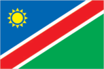
Flag description
a wide red stripe edged by narrow white stripes divides the flag diagonally from lower hoist corner to upper fly corner; the upper hoist-side triangle is blue and charged with a yellow, 12-rayed sunburst; the lower fly-side triangle is green; red signifies the heroism of the people and their determination to build a future of equal opportunity for all; white stands for peace, unity, tranquility, and harmony; blue represents the Namibian sky and the Atlantic Ocean, the country's precious water resources and rain; the yellow sun denotes power and existence; green symbolizes vegetation and agricultural resources
Government type
republic
Independence
21 March 1990 (from South African mandate)
International organization participation
ACP, AfDB, AU, C, FAO, G-77, IAEA, IBRD, ICAO, ICCt, ICRM, IFAD, IFC, IFRCS, ILO, IMF, IMO, Interpol, IOC, IOM, IPU, ISO, ITSO, ITU, ITUC, MIGA, NAM, OPCW, SACU, SADC, UN, UNAMID, UNCTAD, UNESCO, UNHCR, UNIDO, UNMIL, UNMIS, UNOCI, UNWTO, UPU, WCO, WHO, WIPO, WMO, WTO
Judicial branch
Supreme Court (judges appointed by the president on the recommendation of the Judicial Service Commission)
Legal system
based on Roman-Dutch law and 1990 constitution; has not accepted compulsory ICJ jurisdiction
Legislative branch
- bicameral legislature consists of the National Council, primarily an advisory body (26 seats; two members chosen from each regional council to serve six-year terms), and the National Assembly (72 seats; members elected by popular vote to serve five-year terms)
- election results
- National Council - percent of vote by party - SWAPO 89.7%, UDF 4.7%, NUDO 2.8%, DTA 1.9%, other 0.9%; seats by party - SWAPO 24, UDF 1, DTA 1; National Assembly - percent of vote by party - SWAPO 75.3%, RDP 11.3%, DTA 3.1%, NUDO 3.0%, UDF 2.4%, APP 1.4%, RP 0.8%, COD 0.7%, SWANU 0.6%, other 1.3%; seats by party - SWAPO 54, RDP 8, DTA 2, NUDO 2, UDF 2, APP 1, RP 1, COD 1, SWANU 1
- elections
- National Council - elections for regional councils to determine members of the National Council held on 29-30 November 2004 (next to be held on 26-27 November 2010); National Assembly - last held on 26-27 November 2009 (next to be held in November 2014)
National anthem
- lyrics/music
- Axali DOESEB note: adopted 1991
- name
- "Namibia, Land of the Brave"
National holiday
Independence Day, 21 March (1990)
Political parties and leaders
All People's Party or APP [Ignatius SHIXWAMENI]; Congress of Democrats or COD [Benjamin ULENGA]; Democratic Turnhalle Alliance of Namibia or DTA [Katuutire KAURA]; Monitor Action Group or MAG [Jurie VILJOEN]; National Democratic Movement for Change or NamDMC; National Unity Democratic Organization or NUDO [Kuaima RIRUAKO]; Rally for Democracy and Progress or RDP [Hidipo HAMUTENYA]; Republican Party or RP [Hendrick MUDGE]; South West Africa National Union or SWANU [Usutuaije MAAMBERUA]; South West Africa People's Organization or SWAPO [Hifikepunye POHAMBA]; United Democratic Front or UDF [Justus GAROEB]
Political pressure groups and leaders
Earthlife Namibia [Berthchen KOHRS] (environmentalist group); National Society for Human Rights or NSHR; The World Information Services of Energy or WISE (group against nuclear power)
Suffrage
18 years of age; universal
Economy
Agriculture - products
millet, sorghum, peanuts, grapes; livestock; fish
Central bank discount rate
7% (31 December 2009) 10% (31 December 2008)
Commercial bank prime lending rate
11.12% (31 December 2009 est.) 13.74% (31 December 2008 est.)
Current account balance
-$187 million (2010 est.) -$160.9 million (2009 est.)
Debt - external
$2.373 billion (31 December 2010 est.) $2.175 billion (31 December 2009 est.)
Distribution of family income - Gini index
70.7 (2003)
Economy - overview
The economy is heavily dependent on the extraction and processing of minerals for export. Mining accounts for 8% of GDP, but provides more than 50% of foreign exchange earnings. Rich alluvial diamond deposits make Namibia a primary source for gem-quality diamonds. Namibia is the fourth-largest exporter of nonfuel minerals in Africa, the world's fifth-largest producer of uranium, and the producer of large quantities of lead, zinc, tin, silver, and tungsten. The mining sector employs only about 3% of the population while about 35-40% of the population depends on subsistence agriculture for its livelihood. Namibia normally imports about 50% of its cereal requirements; in drought years food shortages are a major problem in rural areas. A high per capita GDP, relative to the region, hides one of the world's most unequal income distributions, as shown by Namibia's GINI coefficient. The Namibian economy is closely linked to South Africa with the Namibian dollar pegged one-to-one to the South African rand. Until 2010, Namibia drew 40% of its budget revenues from the Southern African Customs Union (SACU). Increased payments from SACU put Namibia's budget into surplus in 2007 for the first time since independence. SACU allotments to Namibia increased in 2009, but will drop for 2010 and 2011 because South Africa went into recession during the global economic crisis, reducing overall SACU income. Increased fish production and mining of zinc, copper, uranium, and silver spurred growth in 2003-08, but growth in recent years was undercut by poor fish catches, higher costs of producing metals, and the global recession.
Electricity - consumption
2.845 billion kWh (2009 est.)
Electricity - exports
40 million kWh (2007 est.)
Electricity - imports
2.045 billion kWh (2007 est.)
Electricity - production
1.491 billion kWh (2009 est.)
Exchange rates
Namibian dollars (NAD) per US dollar - 7.57 (2010), 8.4234 (2009), 7.75 (2008), 7.18 (2007), 6.7649 (2006)
Exports
$4.277 billion (2010 est.) $3.535 billion (2009 est.)
Exports - commodities
diamonds, copper, gold, zinc, lead, uranium; cattle, processed fish, karakul skins
GDP - composition by sector
- agriculture
- 9%
- industry
- 32.7%
- services
- 58.2% (2010 est.)
GDP - per capita (PPP)
$6,900 (2010 est.) $6,700 (2009 est.) $6,800 (2008 est.) note: data are in 2010 US dollars
GDP - real growth rate
4.1% (2010 est.) -0.8% (2009 est.) 4.3% (2008 est.)
GDP (official exchange rate)
$11.45 billion (2010 est.)
GDP (purchasing power parity)
$14.64 billion (2010 est.) $14.06 billion (2009 est.) $14.17 billion (2008 est.) note: data are in 2010 US dollars
Household income or consumption by percentage share
lowest 10%: 1.1% highest 10%: 53% (2008)
Imports
$5.152 billion (2010 est.) $4.519 billion (2009 est.)
Imports - commodities
foodstuffs; petroleum products and fuel, machinery and equipment, chemicals
Industrial production growth rate
6.5% (2010 est.)
Industries
meatpacking, fish processing, dairy products; mining (diamonds, lead, zinc, tin, silver, tungsten, uranium, copper)
Inflation rate (consumer prices)
4.6% (2010 est.) 8.8% (2009 est.)
Investment (gross fixed)
24% of GDP (2010 est.)
Labor force
729,000 (2010 est.)
Labor force - by occupation
- agriculture
- 16.3%
- industry
- 22.4%
- services
- 61.3% (2008 est.)
Market value of publicly traded shares
$846.3 million (31 December 2009) $618.7 million (31 December 2008) $702 million (31 December 2007)
Natural gas - consumption
0 cu m (2008 est.)
Natural gas - exports
0 cu m (2008 est.)
Natural gas - imports
0 cu m (2008 est.)
Natural gas - production
0 cu m (2008 est.)
Natural gas - proved reserves
62.29 billion cu m (1 January 2010 est.)
Oil - consumption
22,000 bbl/day (2009 est.)
Oil - exports
0 bbl/day (2007 est.)
Oil - imports
19,120 bbl/day (2007 est.)
Oil - production
0 bbl/day (2009 est.)
Oil - proved reserves
0 bbl (1 January 2010 est.)
Population below poverty line
55.8% note: the UNDP's 2005 Human Development Report indicated that 34.9% of the population live on $1 per day and 55.8% live on $2 per day (2005 est.)
Public debt
20% of GDP (2010 est.) 15.1% of GDP (2009 est.)
Reserves of foreign exchange and gold
$1.961 billion (31 December 2010 est.) $2.051 billion (31 December 2009 est.)
Stock of broad money
$4.756 billion (31 December 2010 est.) $3.691 billion (31 December 2009 est.)
Stock of direct foreign investment - abroad
$NA
Stock of direct foreign investment - at home
$NA
Stock of domestic credit
$5.122 billion (31 December 2010 est.) $4.041 billion (31 December 2009 est.)
Stock of narrow money
$3.049 billion (31 December 2010 est) $2.495 billion (31 December 2009 est)
Unemployment rate
51.2% (2008 est.) 36.7% (2004 est.)
Communications
Broadcast media
1 private and 1 state-run television station; satellite and cable TV service is available; state-run radio service broadcasts in multiple languages; about a dozen private radio stations operating; transmissions of multiple international broadcasters are available (2007)
Internet country code
.na
Internet hosts
76,020 (2010)
Internet users
127,500 (2009)
Telephone system
- domestic
- multiple mobile-cellular providers with a combined subscribership of nearly 60 telephones per 100 persons; combined fixed-line and mobile-cellular teledensity about 65 per 100 persons
- general assessment
- good system; core fiber-optic network links most centers and connections are now digital
- international
- country code - 264; fiber-optic cable to South Africa, microwave radio relay link to Botswana, direct links to other neighboring countries; connected to the South African Far East (SAFE) submarine cable through South Africa; satellite earth stations - 4 Intelsat (2008)
Telephones - main lines in use
142,100 (2009)
Telephones - mobile cellular
1.217 million (2009)
Transportation
Airports
129 (2010)
Airports - with paved runways
- total
- 21 over 3,047 m: 3 2,438 to 3,047 m: 2 1,524 to 2,437 m: 13 914 to 1,523 m: 3 (2010)
Airports - with unpaved runways
- total
- 108 2,438 to 3,047 m: 1 1,524 to 2,437 m: 25 914 to 1,523 m: 71 under 914 m: 11 (2010)
Merchant marine
- by type
- cargo 1 (2010)
- total
- 1
Ports and terminals
Luderitz, Walvis Bay
Railways
- narrow gauge
- 2,629 km 1.067-m gauge (2008)
- total
- 2,629 km
Roadways
- paved
- 5,477 km
- total
- 64,189 km
- unpaved
- 58,712 km (2010)
Military and Security
Manpower available for military service
males age 16-49: 554,531 (2010 est.)
Manpower fit for military service
males age 16-49: 341,783 females age 16-49: 304,496 (2010 est.)
Manpower reaching militarily significant age annually
- female
- 25,790 (2010 est.)
- male
- 26,152
Military branches
- Namibian Defense Force (NDF)
- Army, Navy, Air Force (2010)
Military expenditures
3.7% of GDP (2006)
Military service age and obligation
18 years of age for voluntary military service; no conscription (2010)
Transnational Issues
Disputes - international
concerns from international experts and local populations over the Okavango Delta ecology in Botswana and human displacement scuttled Namibian plans to construct a hydroelectric dam on Popa Falls along the Angola-Namibia border; managed dispute with South Africa over the location of the boundary in the Orange River; Namibia has supported, and in 2004 Zimbabwe dropped objections to, plans between Botswana and Zambia to build a bridge over the Zambezi River, thereby de facto recognizing a short, but not clearly delimited, Botswana-Zambia boundary in the river
Refugees and internally displaced persons
- refugees (country of origin)
- 4,700 (Angola) (2007) page last updated on January 20, 2011 ======================================================================