1999 Edition
CIA World Factbook 1999 (Internet Archive)
Geography
Area
total: 825,418 sq km land: 825,418 sq km water: 0 sq km
Area--comparative
slightly more than half the size of Alaska
Climate
desert; hot, dry; rainfall sparse and erratic
Coastline
1,572 km
Elevation extremes
lowest point: Atlantic Ocean 0 m highest point: Konigstein 2,606 m
Environment--current issues
very limited natural fresh water resources; desertification
Environment--international agreements
party to: Biodiversity, Climate Change, Desertification, Endangered Species, Hazardous Wastes, Law of the Sea, Ozone Layer Protection, Wetlands signed, but not ratified: none of the selected agreements
Geographic coordinates
22 00 S, 17 00 E
Irrigated land
60 sq km (1993 est.)
Land boundaries
total: 3,824 km border countries: Angola 1,376 km, Botswana 1,360 km, South Africa 855 km, Zambia 233 km
Land use
arable land: 1% permanent crops: 0% permanent pastures: 46% forests and woodland: 22% other: 31% (1993 est.)
Location
Southern Africa, bordering the South Atlantic Ocean, between Angola and South Africa
Map references
Africa
Maritime claims
contiguous zone: 24 nm exclusive economic zone: 200 nm territorial sea: 12 nm
Natural hazards
prolonged periods of drought
Natural resources
diamonds, copper, uranium, gold, lead, tin, lithium, cadmium, zinc, salt, vanadium, natural gas, fish; suspected deposits of oil, natural gas, coal, iron ore
Terrain
mostly high plateau; Namib Desert along coast; Kalahari Desert in east
People and Society
Age structure
0-14 years: 44% (male 366,030; female 358,105) 15-64 years: 52% (male 424,879; female 435,116) 65 years and over: 4% (male 26,787; female 37,353) (1999 est.)
Birth rate
35.63 births/1,000 population (1999 est.)
Death rate
19.92 deaths/1,000 population (1999 est.)
Ethnic groups
black 86%, white 6.6%, mixed 7.4% note: about 50% of the population belong to the Ovambo tribe and 9% to the Kavangos tribe; other ethnic groups are: Herero 7%, Damara 7%, Nama 5%, Caprivian 4%, Bushmen 3%, Baster 2%, Tswana 0.5%
Infant mortality rate
65.94 deaths/1,000 live births (1999 est.)
Languages
English 7% (official), Afrikaans common language of most of the population and about 60% of the white population, German 32%, indigenous languages: Oshivambo, Herero, Nama
Life expectancy at birth
total population: 41.26 years male: 41.64 years female: 40.87 years (1999 est.)
Literacy
definition: age 15 and over can read and write total population: 38% male: 45% female: 31% (1960 est.)
Nationality
noun: Namibian(s) adjective: Namibian
Net migration rate
0 migrant(s)/1,000 population (1999 est.)
Population
1,648,270 (July 1999 est.)
Population growth rate
1.57% (1999 est.)
Religions
Christian 80% to 90% (Lutheran 50% at least, other Christian denominations 30%), native religions 10% to 20%
Sex ratio
at birth: 1.03 male(s)/female under 15 years: 1.02 male(s)/female 15-64 years: 0.98 male(s)/female 65 years and over: 0.72 male(s)/female total population: 0.98 male(s)/female (1999 est.)
Total fertility rate
4.94 children born/woman (1999 est.)
Government
Administrative divisions
13 regions; Caprivi, Erongo, Hardap, Karas, Khomas, Kunene, Ohangwena, Okavango, Omaheke, Omusati, Oshana, Oshikoto, Otjozondjupa
Capital
Windhoek
Constitution
ratified 9 February 1990; effective 12 March 1990
Country name
conventional long form: Republic of Namibia conventional short form: Namibia
Data code
WA
Executive branch
chief of state: President Sam NUJOMA (since 21 March 1990); note--the president is both the chief of state and head of government head of government: President Sam NUJOMA (since 21 March 1990); note--the president is both the chief of state and head of government cabinet: Cabinet appointed by the president from among the members of the National Assembly elections: president elected by popular vote for a five-year term; election last held 7-8 December 1994 (next to be held NA December 1999) election results: Sam NUJOMA elected president; percent of vote--76%
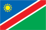
Flag description
a large blue triangle with a yellow sunburst fills the upper left section and an equal green triangle (solid) fills the lower right section; the triangles are separated by a red stripe that is contrasted by two narrow white-edge borders
Government type
republic
Independence
21 March 1990 (from South African mandate)
International organization participation
ACP, AfDB, C, CCC, ECA, FAO, G-77, IAEA, IBRD, ICAO, ICRM, IFAD, IFC, IFRCS, ILO, IMF, IMO, Intelsat, Interpol, IOC, IOM (observer), ISO (subscriber), ITU, MONUA, NAM, OAU, OPCW, SACU, SADC, UN, UNCTAD, UNESCO, UNHCR, UNIDO, UPU, WCL, WHO, WIPO, WMO, WToO, WTrO Diplomatic representation in the US: chief of mission: Ambassador (vacant); Charge d'Affaires Usko SHIVUTE chancery: 1605 New Hampshire Avenue NW, Washington, DC 20009 Diplomatic representation from the US: chief of mission: Ambassador George F. WARD, Jr. embassy: Ausplan Building, 14 Lossen St., Private Bag 12029 Ausspannplatz, Windhoek mailing address: use embassy street address
Judicial branch
Supreme Court, judges appointed by the president Political parties and leaders: South West Africa People's KATJIUONGUA] Political pressure groups and leaders: NA
Legal system
based on Roman-Dutch law and 1990 constitution
Legislative branch
bicameral legislature consists of the National Council (26 seats; two members are chosen from each regional council to serve six-year terms) and the National Assembly (72 seats; members are elected by popular vote to serve five-year terms) elections: National Council--last held 30 November-1 December 1998 (next to be held by December 2004); National Assembly--last held 7-8 December 1994 (next to be held NA December 1999) election results: National Council--percent of vote by party--NA; seats by party--NA; National Assembly--percent of vote by party--SWAPO 73.89%, DTA 20.78%, UDF 2.72%, DCN 0.83%, MAG 0.82%; seats by party--SWAPO 53, DTA 15, UDF 2, MAG 1, DCN 1 note: the National Council is a purely advisory body
National holiday
Independence Day, 21 March (1990)
Suffrage
18 years of age; universal
Economy
Agriculture--products
millet, sorghum, peanuts; livestock; fish
Budget
revenues: $1.1 billion expenditures: $1.2 billion, including capital expenditures of $193 million (FY96/97 est.)
Currency
1 Namibian dollar (N$) = 100 cents
Debt--external
$315 million (1996 est.)
Economic aid--recipient
$127 million (1998)
Economy--overview
The economy is heavily dependent on the extraction and processing of minerals for export. Mining accounts for 20% of GDP. Namibia is the fourth-largest exporter of nonfuel minerals in Africa and the world's fifth-largest producer of uranium. Rich alluvial diamond deposits make Namibia a primary source for gem-quality diamonds. Namibia also produces large quantities of lead, zinc, tin, silver, and tungsten. Half of the population depends on agriculture (largely subsistence agriculture) for its livelihood. Namibia must import some of its food. Although per capita GDP is three times the per capita GDP of Africa's poorer countries, the majority of Namibia's people live in pronounced poverty because of the great inequality of income distribution and the large amounts going to foreigners. The Namibian economy has close links to South Africa.
Electricity--consumption
1.11 billion kWh (1996)
Electricity--exports
0 kWh (1996)
Electricity--imports
1.11 billion kWh (1996) note: imports electricity from South Africa
Electricity--production
0 kWh (1996)
Electricity--production by source
fossil fuel: NA% hydro: NA% nuclear: NA% other: NA%
Exchange rates
Nambian dollars (N$) per US$1--5.98380 (January 1999), 5.52828 (1998), 4.60796 (1997), 4.29935 (1996), 3.62709 (1995), 3.55080 (1994)
Exports
$1.44 billion (f.o.b., 1998 est.)
Exports--commodities
diamonds, copper, gold, zinc, lead, uranium; cattle, processed fish, karakul skins
Exports--partners
UK 38%, South Africa 24%, Spain 12%, Japan 7% (1996 est.)
Fiscal year
1 April--31 March
GDP
purchasing power parity--$6.6 billion (1998 est.)
GDP--composition by sector
agriculture: 11% industry: 34% services: 55% (1997 est.)
GDP--per capita
purchasing power parity?$4,100 (1998 est.)
GDP--real growth rate
2% (1998 est.)
Household income or consumption by percentage share
lowest 10%: NA% highest 10%: NA%
Imports
$1.48 billion (f.o.b., 1998 est.)
Imports--commodities
foodstuffs; petroleum products and fuel, machinery and equipment, chemicals
Imports--partners
South Africa 87%, Germany, US, Japan (1995 est.)
Industrial production growth rate
10% (1994)
Industries
meat packing, fish processing, dairy products; mining (diamond, lead, zinc, tin, silver, tungsten, uranium, copper)
Inflation rate (consumer prices)
7% (1996 est.)
Labor force
500,000
Labor force--by occupation
agriculture 49%, industry and commerce 25%, services 5%, government 18%, mining 3% (1994 est.)
Population below poverty line
NA%
Unemployment rate
30% to 40%, including underemployment (1997 est.)
Communications
Radio broadcast stations
AM 4, FM 40, shortwave 0
Radios
195,000 (1992 est.)
Telephone system
domestic: good urban services; fair rural service; microwave radio relay links major towns; connections to other populated places are by open wire international: NA note: a fully automated digital network is being implemented
Telephones
89,722 (1992 est.)
Television broadcast stations
8 (of which five are main stations and three are low-power stations; there are also about 20 low-power repeaters) (1997)
Televisions
27,000 (1993 est.)
Transportation
Airports
135 (1998 est.) Airports--with paved runways: total: 22 over 3,047 m: 2 2,438 to 3,047 m: 2 1,524 to 2,437 m: 15 914 to 1,523 m: 3 (1998 est.) Airports--with unpaved runways: total: 113 2,438 to 3,047 m: 2 1,524 to 2,437 m: 20 914 to 1,523 m: 70 under 914 m: 21 (1998 est.)
Highways
total: 64,799 km paved: 7,841 km unpaved: 56,958 km (1996 est.) Ports and harbors: Luderitz, Walvis Bay
Merchant marine
none
Railways
total: 2,382 km narrow gauge: 2,382 km 1.067-m gauge; single track (1995)
Military and Security
Military branches
National Defense Force (Army), Police
Military expenditures--dollar figure
$90 million (FY97/98)
Military expenditures--percent of GDP
2.6% (FY97/98)
Military manpower--availability
males age 15-49: 380,528 (1999 est.) Military manpower--fit for military service: males age 15-49: 228,225 (1999 est.)
Transnational Issues
Disputes--international
quadripoint with Botswana, Zambia, and Zimbabwe is in disagreement; dispute with Botswana over uninhabited Kasikili (Sidudu) Island in Linyanti (Chobe) River is presently at the ICJ; at least one other island in Linyanti River is contested