1993 Edition
CIA World Factbook 1993 (Project Gutenberg)
Geography
Area
total area: 824,290 km2 land area: 823,290 km2 comparative area: slightly more than half the size of Alaska
Climate
desert; hot, dry; rainfall sparse and erratic
Coastline
1,489 km
Environment
inhospitable with very limited natural water resources; desertification
International disputes
short section of boundary with Botswana is indefinite; disputed island with Botswana in the Chobe River; quadripoint with Botswana, Zambia, and Zimbabwe is in disagreement; claim by Namibia to Walvis Bay and 12 offshore islands administered by South Africa; Namibia and South Africa have agreed to jointly administer the area for an interim period; the terms and dates to be covered by joint administration arrangements have not been established at this time, and Namibia will continue to maintain a claim to sovereignty over the entire area; recent dispute with Botswana over uninhabited Kasikili (Sidudu) Island in the Linyanti River
Irrigated land
40 km2 (1989 est.)
Land boundaries
total 3,935 km, Angola 1,376 km, Botswana 1,360 km, South Africa 966 km, Zambia 233 km
Land use
arable land: 1% permanent crops: 0% meadows and pastures: 64% forest and woodland: 22% other: 13%
Location
Southern Africa, bordering the South Atlantic Ocean between Angola and South Africa
Map references
Africa, Standard Time Zones of the World
Maritime claims
contiguous zone: 24 nm exclusive economic zone: 200 nm territorial sea: 12 nm
Natural resources
diamonds, copper, uranium, gold, lead, tin, lithium, cadmium, zinc, salt, vanadium, natural gas, fish; suspected deposits of oil, natural gas, coal, iron ore
Note
Walvis Bay area is an exclave of South Africa in Namibia
Terrain
mostly high plateau; Namib Desert along coast; Kalahari Desert in east
People and Society
Birth rate
43.77 births/1,000 population (1993 est.)
Death rate
9.13 deaths/1,000 population (1993 est.)
Ethnic divisions
black 86%, white 6.6%, mixed 7.4% note: about 50% of the population belong to the Ovambo tribe and 9% to the Kavangos tribe
Infant mortality rate
63.8 deaths/1,000 live births (1993 est.)
Labor force
500,000 by occupation: agriculture 60%, industry and commerce 19%, services 8%, government 7%, mining 6% (1981 est.)
Languages
English 7% (official), Afrikaans common language of most of the population and about 60% of the white population, German 32%, indigenous languages
Life expectancy at birth
total population: 61.2 years male: 58.57 years female: 63.91 years (1993 est.)
Literacy
age 15 and over can read and write (1960) total population: 38% male: 45% female: 31%
Nationality
noun: Namibian(s) adjective: Namibian
Net migration rate
0 migrant(s)/1,000 population (1993 est.)
Population
1,541,321 (July 1993 est.)
Population growth rate
3.46% (1993 est.)
Religions
Christian
Total fertility rate
6.46 children born/woman (1993 est.)
Government
Administrative divisions
13 districts; Erango, Hardap, Karas, Khomas, Kunene, Liambezi, Ohanguena, Okarango, Omaheke, Omusat, Oshana, Oshikoto, Otjozondjupa note: the 26 districts were Bethanien, Boesmanland, Caprivi Oos, Damaraland, Gobabis, Grootfontein, Hereroland Oos, Hereroland Wes, Kaokoland, Karasburg, Karibib, Kavango, Keetmanshoop, Luderitz, Maltahohe, Mariental, Namaland, Okahandja, Omaruru, Otjiwarongo, Outjo, Owambo, Rehoboth, Swakopmund, Tsumeb, Windhoek
Capital
Windhoek
Chief of State and Head of Government
President Sam NUJOMA (since 21 March 1990)
Constitution
ratified 9 February 1990
Digraph
WA
Diplomatic representation in US
chief of mission: Ambassador Tuliameni KALOMOH chancery: 1605 New Hampshire Ave. NW, Washington, DC 20009 (mailing address is PO Box 34738, Washington, DC 20043) telephone: (202) 986-0540
Executive branch
president, Cabinet
FAX
[264] (61) 229-792
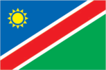
Flag
a large blue triangle with a yellow sunburst fills the upper left section, and an equal green triangle (solid) fills the lower right section; the triangles are separated by a red stripe that is contrasted by two narrow white-edge borders
Independence
21 March 1990 (from South African mandate)
Judicial branch
Supreme Court
Legal system
based on Roman-Dutch law and 1990 constitution
Legislative branch
bicameral legislature consists of an upper house or National Council and a lower house or National Assembly
Member of
ACP, C, ECA, FAO, FLS, G-77, IAEA, IBRD, ICAO, IFAD, IFC, ILO, IMF, IOM (observer), ITU, NAM, OAU, SACU, SADC, UN, UNCTAD, UNESCO, UNHCR, UNIDO, UPU, WCL, WFTU, WHO, WIPO, WMO
Names
conventional long form: Republic of Namibia conventional short form: Namibia
National Assembly
last held on 7-11 November 1989 (next to be held by November 1994); results - percent of vote by party NA; seats - (72 total) SWAPO 41, DTA 21, UDF 4, ACN 3, NNF 1, FCN 1, NPF 1
National Council
last held 30 November-3 December 1992 (next to be held by December 1998); seats - (26 total) SWAPO 19, DTA 6, UDF 1
National holiday
Independence Day, 21 March (1990)
Other political or pressure groups
NA
Political parties and leaders
South West Africa People's Organization (SWAPO), Sam NUJOMA; DTA of Namibia (DTA; formerly Democratic Turnhalle Alliance of Namibia), Dirk MUDGE; United Democratic Front (UDF), Justus GAROEB; Action Christian National (ACN), Kosie PRETORIUS; National Patriotic Front (NPF), Moses KATJIUONGUA; Federal Convention of Namibia (FCN), Hans DIERGAARDT; Namibia National Front (NNF), Vekuii RUKORO
President
last held 16 February 1990 (next to be held March 1995); results - Sam NUJOMA was elected president by the Constituent Assembly (now the National Assembly)
Suffrage
18 years of age; universal
Type
republic
US diplomatic representation
chief of mission: Charge d'Affaires Marshall MCCAULEY embassy: Ausplan Building, 14 Lossen St., Windhoek mailing address: P. O. Box 9890, Windhoek 9000 telephone: [264] (61) 221-601, 222-675, 222-680
Economy
Agriculture
accounts for 15% of GDP; mostly subsistence farming; livestock raising major source of cash income; crops - millet, sorghum, peanuts; fish catch potential of over 1 million metric tons not being fulfilled, 1988 catch reaching only 384,000 metric tons; not self-sufficient in food
Budget
revenues $864 million; expenditures $1,112 million, including capital expenditures of $144 million (FY 92)
Currency
1 South African rand (R) = 100 cents
Economic aid
Western (non-US) countries, ODA and OOF bilateral commitments (1970-87), $47.2 million
Electricity
490,000 kW capacity; 1,290 million kWh produced, 850 kWh per capita (1991)
Exchange rates
South African rand (R) per US$1 - 3.1576 (May 1993), 2.8497 (1992), 2.7653 (1991), 2.5863 (1990), 2.6166 (1989), 2.2611 (1988)
Exports
$1.184 billion (f.o.b., 1991) commodities: diamonds, copper, gold, zinc, lead, uranium, cattle, processed fish, karakul skins partners: Switzerland, South Africa, Germany, Japan
External debt
about $220 million (1992 est.)
Fiscal year
1 April - 31 March
Imports
$1.238 billion (f.o.b., 1991)
Industrial production
growth rate 4.9% (1991); accounts for 35% of GDP, including mining
Industries
meatpacking, fish processing, dairy products, mining (copper, lead, zinc, diamond, uranium)
Inflation rate (consumer prices)
10% (1992) in urban area
National product
GDP - exchange rate conversion - $2 billion (1992 est.)
National product per capita
$1,300 (1992 est.)
National product real growth rate
2% (1992 est.)
Overview
The economy is heavily dependent on the mining industry to extract and process minerals for export. Mining accounts for almost 25% of GDP. Namibia is the fourth-largest exporter of nonfuel minerals in Africa and the world's fifth-largest producer of uranium. Alluvial diamond deposits are among the richest in the world, making Namibia a primary source for gem-quality diamonds. Namibia also produces large quantities of lead, zinc, tin, silver, and tungsten. More than half the population depends on agriculture (largely subsistence agriculture) for its livelihood.
Unemployment rate
25-35% (1992)
Communications
Airports
total: 137 usable: 112 with permanent-surface runways: 21 with runways over 3,659 m: 1 with runways 2,440-3,659 m: 4 with runways 1,220-2,439 m: 62
Highways
54,500 km; 4,079 km paved, 2,540 km gravel, 47,881 km earth roads and tracks
Ports
Luderitz; primary maritime outlet is Walvis Bay (South Africa)
Railroads
2,341 km 1.067-meter gauge, single track
Telecommunications
good urban, fair rural services; radio relay connects major towns, wires extend to other population centers; 62,800 telephones; broadcast stations - 4 AM, 40 FM, 3 TV
Military and Security
Branches
National Defense Force (Army), Police
Defense expenditures
exchange rate conversion - $66 million, 3.4% of GDP (FY92)
Manpower availability
males age 15-49 324,599; fit for military service 192,381 (1993 est.)