2022 Edition
CIA World Factbook 2022 (factbook.json @ 61dadec0c9c9)
Introduction
Background
In the first half of the second millennium A.D., northern Mozambican port towns were frequented by traders from Somalia, Ethiopia, Egypt, Arabia, Persia, and India. The Portuguese were able to wrest much of the coastal trade from Arab Muslims in the centuries after 1500 and to set up their own colonies. Portugal did not relinquish Mozambique until 1975. Large-scale emigration, economic dependence on South Africa, a severe drought, and a prolonged civil war hindered the country's development until the mid-1990s. The ruling Front for the Liberation of Mozambique (FRELIMO) party formally abandoned Marxism in 1989, and a new constitution the following year provided for multiparty elections and a free market economy. A UN-negotiated peace agreement between FRELIMO and rebel Mozambique National Resistance (RENAMO) forces ended the fighting in 1992. In 2004, Mozambique underwent a delicate transition as Joaquim CHISSANO stepped down after 18 years in office. His elected successor, Armando GUEBUZA, served two terms and then passed executive power to Filipe NYUSI in 2015. RENAMO’s residual armed forces intermittently engaged in a low-level insurgency after 2012, but a late December 2016 cease-fire eventually led to the two sides signing a comprehensive peace deal in August 2019. Elections in October 2019, challenged by Western observers and civil society as being problematic, resulted in resounding wins for NYUSI and FRELIMO across the country. Since October 2017, violent extremists - who an official ISIS media outlet recognized as ISIS's network in Mozambique for the first time in June 2019 - have been conducting attacks against civilians and security services in the northern province of Cabo Delgado. In 2021, Rwanda and the Southern African Development Community deployed forces to support Mozambique’s efforts to counter the extremist group.
Geography
Area
- land
- 786,380 sq km
- total
- 799,380 sq km
- water
- 13,000 sq km
Area - comparative
slightly more than five times the size of Georgia; slightly less than twice the size of California
Climate
tropical to subtropical
Coastline
2,470 km
Elevation
- highest point
- Monte Binga 2,436 m
- lowest point
- Indian Ocean 0 m
- mean elevation
- 345 m
Geographic coordinates
18 15 S, 35 00 E
Geography - note
the Zambezi River flows through the north-central and most fertile part of the country
Irrigated land
1,180 sq km (2012)
Land boundaries
- border countries
- Malawi 1498 km; South Africa 496 km; Eswatini 108 km; Tanzania 840 km; Zambia 439 km; Zimbabwe 1,402 km
- total
- 4,783 km
Land use
- agricultural land
- 56.3% (2018 est.)
- agricultural land: arable land
- arable land: 6.4% (2018 est.)
- agricultural land: permanent crops
- permanent crops: 0.3% (2018 est.)
- agricultural land: permanent pasture
- permanent pasture: 49.6% (2018 est.)
- forest
- 43.7% (2018 est.)
- other
- 0% (2018 est.)
Location
Southeastern Africa, bordering the Mozambique Channel, between South Africa and Tanzania
Major lakes (area sq km)
- fresh water lake(s)
- Lake Malawi (shared with Malawi and Tanzania) - 22,490
Major rivers (by length in km)
Zambezi river mouth (shared with Zambia [s]), Angola, Namibia, Botswana, and Zimbabwe) - 2,740 km; Limpopo river mouth (shared with South Africa [s], Botswana, and Zimbabwe) - 1,800 kmnote – [s] after country name indicates river source; [m] after country name indicates river mouth
Major watersheds (area sq km)
Indian Ocean drainage: Zambezi (1,332,412 sq km)
Map references
Africa
Maritime claims
- exclusive economic zone
- 200 nm
- territorial sea
- 12 nm
Natural hazards
severe droughts; devastating cyclones and floods in central and southern provinces
Natural resources
coal, titanium, natural gas, hydropower, tantalum, graphite
Population distribution
three large populations clusters are found along the southern coast between Maputo and Inhambane, in the central area between Beira and Chimoio along the Zambezi River, and in and around the northern cities of Nampula, Cidade de Nacala, and Pemba; the northwest and southwest are the least populated areas as shown in this population distribution map
Terrain
mostly coastal lowlands, uplands in center, high plateaus in northwest, mountains in west
People and Society
Age structure
- 0-14 years
- 45.57% (male 6,950,800/female 6,766,373)
- 15-24 years
- 19.91% (male 2,997,529/female 2,994,927)
- 25-54 years
- 28.28% (male 3,949,085/female 4,564,031)
- 55-64 years
- 3.31% (male 485,454/female 509,430)
- 65 years and over
- 2.93% (male 430,797/female 449,771) (2020 est.)
Alcohol consumption per capita
- beer
- 1.03 liters of pure alcohol (2019 est.)
- other alcohols
- 0 liters of pure alcohol (2019 est.)
- spirits
- 0.21 liters of pure alcohol (2019 est.)
- total
- 1.46 liters of pure alcohol (2019 est.)
- wine
- 0.22 liters of pure alcohol (2019 est.)
Birth rate
37.47 births/1,000 population (2022 est.)
Children under the age of 5 years underweight
15.6% (2014/15)
Contraceptive prevalence rate
27.1% (2015)
Current health expenditure
7.8% of GDP (2019)
Death rate
10.25 deaths/1,000 population (2022 est.)
Demographic profile
Mozambique is a poor, sparsely populated country with high fertility and mortality rates and a rapidly growing youthful population – 45% of the population is younger than 15, as of 2022. Mozambique’s high poverty rate is sustained by natural disasters, disease, high population growth, low agricultural productivity, and the unequal distribution of wealth. The country’s birth rate is among the world’s highest, averaging around more than 5 children per woman (and higher in rural areas) for at least the last three decades. The sustained high level of fertility reflects gender inequality, low contraceptive use, early marriages and childbearing, and a lack of education, particularly among women. The high population growth rate is somewhat restrained by the country’s high HIV/AIDS and overall mortality rates. Mozambique ranks among the worst in the world for HIV/AIDS prevalence, HIV/AIDS deaths, and life expectancy at birth, as of 2022. Mozambique is predominantly a country of emigration, but internal, rural-urban migration has begun to grow. Mozambicans, primarily from the country’s southern region, have been migrating to South Africa for work for more than a century. Additionally, approximately 1.7 million Mozambicans fled to Malawi, South Africa, and other neighboring countries between 1979 and 1992 to escape from civil war. Labor migrants have usually been men from rural areas whose crops have failed or who are unemployed and have headed to South Africa to work as miners; multiple generations of the same family often become miners. Since the abolition of apartheid in South Africa in 1991, other job opportunities have opened to Mozambicans, including in the informal and manufacturing sectors, but mining remains their main source of employment.
Dependency ratios
- elderly dependency ratio
- 4.8
- potential support ratio
- 20.8 (2021 est.)
- total dependency ratio
- 86.1
- youth dependency ratio
- 81.3
Drinking water source
- improved: rural
- rural: 61.5% of population
- improved: total
- total: 73.3% of population
- improved: urban
- urban: 93.4% of population
- unimproved: rural
- rural: 38.5% of population
- unimproved: total
- total: 26.7% of population (2020 est.)
- unimproved: urban
- urban: 6.6% of population
Education expenditures
6.3% of GDP (2020 est.)
Ethnic groups
African 99% (Makhuwa, Tsonga, Lomwe, Sena, and others), Mestizo 0.8%, other (includes European, Indian, Pakistani, Chinese) 0.2% (2017 est.)
HIV/AIDS - adult prevalence rate
(2021 est.) NA
Hospital bed density
0.7 beds/1,000 population (2011)
Infant mortality rate
- female
- 59.33 deaths/1,000 live births (2022 est.)
- male
- 63.37 deaths/1,000 live births
- total
- 61.38 deaths/1,000 live births
Languages
Makhuwa 26.1%, Portuguese (official) 16.6%, Tsonga 8.6%, Nyanja 8.1, Sena 7.1%, Lomwe 7.1%, Chuwabo 4.7%, Ndau 3.8%, Tswa 3.8%, other Mozambican languages 11.8%, other 0.5%, unspecified 1.8% (2017 est.)
Life expectancy at birth
- female
- 58.49 years (2022 est.)
- male
- 55.76 years
- total population
- 57.1 years
Literacy
- definition
- age 15 and over can read and write
- female
- 50.3% (2017)
- male
- 72.6%
- total population
- 60.7%
Major infectious diseases
- animal contact diseases
- rabies
- degree of risk
- very high (2020)
- food or waterborne diseases
- bacterial and protozoal diarrhea, hepatitis A, and typhoid fever
- note
- note: on 21 March 2022, the US Centers for Disease Control and Prevention (CDC) issued a Travel Alert for polio in Africa; Mozambique is currently considered a high risk to travelers for circulating vaccine-derived polioviruses (cVDPV); vaccine-derived poliovirus (VDPV) is a strain of the weakened poliovirus that was initially included in oral polio vaccine (OPV) and that has changed over time and behaves more like the wild or naturally occurring virus; this means it can be spread more easily to people who are unvaccinated against polio and who come in contact with the stool or respiratory secretions, such as from a sneeze, of an “infected” person who received oral polio vaccine; the CDC recommends that before any international travel, anyone unvaccinated, incompletely vaccinated, or with an unknown polio vaccination status should complete the routine polio vaccine series; before travel to any high-risk destination, the CDC recommends that adults who previously completed the full, routine polio vaccine series receive a single, lifetime booster dose of polio vaccine
- vectorborne diseases
- malaria and dengue fever
- water contact diseases
- schistosomiasis
Major urban areas - population
1.852 million Matola, 1.163 million MAPUTO (capital), 969,000 Nampula (2023)
Maternal mortality ratio
289 deaths/100,000 live births (2017 est.)
Median age
- female
- 17.6 years (2020 est.)
- male
- 16.3 years
- total
- 17 years
Mother's mean age at first birth
- 19.2 years (2011 est.)
- note
- note: data represents median age at first birth among women 20-49
Nationality
- adjective
- Mozambican
- noun
- Mozambican(s)
Net migration rate
-1.58 migrant(s)/1,000 population (2022 est.)
Obesity - adult prevalence rate
7.2% (2016)
Physicians density
0.09 physicians/1,000 population (2020)
Population
31,693,239 (2022 est.)
Population distribution
three large populations clusters are found along the southern coast between Maputo and Inhambane, in the central area between Beira and Chimoio along the Zambezi River, and in and around the northern cities of Nampula, Cidade de Nacala, and Pemba; the northwest and southwest are the least populated areas as shown in this population distribution map
Population growth rate
2.56% (2022 est.)
Religions
Roman Catholic 27.2%, Muslim 18.9%, Zionist Christian 15.6%, Evangelical/Pentecostal 15.3%, Anglican 1.7%, other 4.8%, none 13.9%, unspecified 2.5% (2017 est.)
Sanitation facility access
- improved: rural
- rural: 24.7% of population
- improved: total
- total: 42.2% of population
- improved: urban
- urban: 71.9% of population (2015 est.)
- unimproved: rural
- rural: 75.3% of population
- unimproved: total
- total: 57.8% of population (2020 est.)
- unimproved: urban
- urban: 28.1% of population
School life expectancy (primary to tertiary education)
- female
- 9 years (2017)
- male
- 10 years
- total
- 10 years
Sex ratio
- 0-14 years
- 1.03 male(s)/female
- 15-24 years
- 1 male(s)/female
- 25-54 years
- 0.86 male(s)/female
- 55-64 years
- 0.94 male(s)/female
- 65 years and over
- 0.88 male(s)/female
- at birth
- 1.03 male(s)/female
- total population
- 0.97 male(s)/female (2022 est.)
Tobacco use
- female
- 5.6% (2020 est.)
- male
- 23% (2020 est.)
- total
- 14.3% (2020 est.)
Total fertility rate
4.81 children born/woman (2022 est.)
Urbanization
- rate of urbanization
- 4.24% annual rate of change (2020-25 est.)
- urban population
- 38.8% of total population (2023)
Youth unemployment rate (ages 15-24)
- female
- 7.1% (2015 est.)
- male
- 7.7%
- total
- 7.4%
Government
Administrative divisions
10 provinces (provincias, singular - provincia), 1 city (cidade)*; Cabo Delgado, Gaza, Inhambane, Manica, Maputo, Cidade de Maputo*, Nampula, Niassa, Sofala, Tete, Zambezia
Capital
- etymology
- reputedly named after the Maputo River, which drains into Maputo Bay south of the city
- geographic coordinates
- 25 57 S, 32 35 E
- name
- Maputo
- time difference
- UTC+2 (7 hours ahead of Washington, DC, during Standard Time)
Citizenship
- citizenship by birth
- no
- citizenship by descent only
- at least one parent must be a citizen of Mozambique
- dual citizenship recognized
- no
- residency requirement for naturalization
- 5 years
Constitution
- amendments
- proposed by the president of the republic or supported by at least one third of the Assembly of the Republic membership; passage of amendments affecting constitutional provisions, including the independence and sovereignty of the state, the republican form of government, basic rights and freedoms, and universal suffrage, requires at least a two-thirds majority vote by the Assembly and approval in a referendum; referenda not required for passage of other amendments; amended 2007, 2018
- history
- previous 1975, 1990; latest adopted 16 November 2004, effective 21 December 2004
Country name
- conventional long form
- Republic of Mozambique
- conventional short form
- Mozambique
- etymology
- named for the offshore island of Mozambique; the island was apparently named after Mussa al-BIK, an influential Arab slave trader who set himself up as sultan on the island in the 15th century
- former
- Portuguese East Africa, People's Republic of Mozambique
- local long form
- Republica de Mocambique
- local short form
- Mocambique
Diplomatic representation from the US
- chief of mission
- Ambassador Peter Hendrick VROOMAN (since 3 March 2022)
- email address and website
- consularmaputos@state.govhttps://mz.usembassy.gov/
- embassy
- Avenida Kenneth Kaunda, 193, Caixa Postal, 783, Maputo
- FAX
- [258] (21) 49-01-14
- mailing address
- 2330 Maputo Place, Washington DC 20521-2330
- telephone
- [258] (21) 49-27-97
Diplomatic representation in the US
- chancery
- 1525 New Hampshire Avenue NW, Washington, DC 20036
- chief of mission
- Ambassador Carlos DOS SANTOS (since 28 January 2016)
- email address and website
- washington.dc@embamoc.gov.mzhttps://usa.embamoc.gov.mz/
- FAX
- [1] (202) 835-0245
- telephone
- [1] (202) 293-7147
Executive branch
- cabinet
- Cabinet appointed by the president
- chief of state
- President Filipe Jacinto NYUSI (since 15 January 2015); note - the president is both chief of state and head of government
- election results
- 2019: Filipe NYUSI elected president in first round; percent of vote - Filipe NYUSI (FRELIMO) 73.0%, Ossufo MOMADE (RENAMO) 21.9%, Daviz SIMANGO (MDM) 5.1%2014: Filipe NYUSI elected president in first round; percent of vote - Filipe NYUSI (FRELIMO) 57.0%, Afonso DHLAKAMA (RENAMO) 36.6%, Daviz SIMANGO (MDM) 6.4%
- elections/appointments
- president elected directly by absolute majority popular vote in 2 rounds if needed for a 5-year term (eligible for 2 consecutive terms); election last held on 15 October 2019 (next to be held on 15 October 2024); prime minister appointed by the president
- head of government
- President Filipe Jacinto NYUSI (since 15 January 2015); Prime Minister Adriano Afonso MALEIANE (since 3 March 2022); note - President NYUSI removed former Prime Minister Carlos Agostinho DO ROSARIO from office on 3 March 2022 as part of a cabinet reshuffle
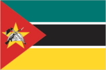
Flag description
- three equal horizontal bands of green (top), black, and yellow with a red isosceles triangle based on the hoist side; the black band is edged in white; centered in the triangle is a yellow five-pointed star bearing a crossed rifle and hoe in black superimposed on an open white book; green represents the riches of the land, white peace, black the African continent, yellow the country's minerals, and red the struggle for independence; the rifle symbolizes defense and vigilance, the hoe refers to the country's agriculture, the open book stresses the importance of education, and the star represents Marxism and internationalism
- note
- note: one of only two national flags featuring a firearm, the other is Guatemala
Government type
presidential republic
Independence
25 June 1975 (from Portugal)
International law organization participation
has not submitted an ICJ jurisdiction declaration; non-party state to the ICCt
International organization participation
ACP, AfDB, AU, C, CD, CPLP, EITI (compliant country), FAO, G-77, IAEA, IBRD, ICAO, ICC (NGOs), ICRM, IDA, IDB, IFAD, IFC, IFRCS, IHO, ILO, IMF, IMO, IMSO, Interpol, IOC, IOM, IPU, ISO (correspondent), ITSO, ITU, ITUC (NGOs), MIGA, NAM, OIC, OIF (observer), OPCW, SADC, UN, UNCTAD, UNESCO, UNHCR, UNIDO, Union Latina, UNISFA, UNWTO, UPU, WCO, WFTU (NGOs), WHO, WIPO, WMO, WTO
Judicial branch
- highest court(s)
- Supreme Court (consists of the court president, vice president, and 5 judges); Constitutional Council (consists of 7 judges); note - the Higher Council of the Judiciary Magistracy is responsible for judiciary management and discipline
- judge selection and term of office
- Supreme Court president appointed by the president of the republic; vice president appointed by the president in consultation with the Higher Council of the Judiciary (CSMJ) and ratified by the Assembly of the Republic; other judges elected by the Assembly; judges serve 5-year renewable terms; Constitutional Council judges appointed - 1 by the president, 5 by the Assembly, and 1 by the CSMJ; judges serve 5-year nonrenewable terms
- subordinate courts
- Administrative Court (capital city only); provincial courts or Tribunais Judicias de Provincia; District Courts or Tribunais Judicias de Districto; customs courts; maritime courts; courts marshal; labor courts; community courts
Legal system
mixed legal system of Portuguese civil law and customary law; note - in rural, apply where applicable predominantly Muslim villages with no formal legal system, Islamic law may be applied
Legislative branch
- description
- unicameral Assembly of the Republic or Assembleia da Republica (250 seats; 248 members elected in multi-seat constituencies by party-list proportional representation vote and 2 members representing Mozambicans abroad directly elected by simple majority vote; members serve 5-year terms) (2019)
- election results
- percent of vote by party - FRELIMO 71%, RENAMO 23%, MDM 4%; seats by party - FRELIMO 184, RENAMO 60, MDM 6; composition as of July 2022 - men 144, women 106, percent of women 42.4% (2019)
- elections
- last held on 15 October 2019 (next to be held on 15 October 2024) (2019)
National anthem
- lyrics/music
- Salomao J. MANHICA/unknown
- name
- "Patria Amada" (Lovely Fatherland)
- note
- note: adopted 2002
National heritage
- selected World Heritage Site locales
- Island of Mozambique
- total World Heritage Sites
- 1 (cultural)
National holiday
Independence Day, 25 June (1975)
National symbol(s)
national colors: green, black, yellow, white, red
Political parties and leaders
Democratic Movement of Mozambique (Movimento Democratico de Mocambique) or MDM [Lutero SIMANGO]Liberation Front of Mozambique (Frente de Liberatacao de Mocambique) or FRELIMO [Filipe NYUSI]Mozambican National Resistance (Resistencia Nacional Mocambicana) or RENAMO [Ossufo MOMADE]note: only parties with seats in the legislature listed
Suffrage
18 years of age; universal
Economy
Agricultural products
sugar cane, cassava, maize, milk, bananas, tomatoes, sweet potatoes, rice, sorghum, potatoes
Budget
- expenditures
- 4.054 billion (2017 est.)
- revenues
- 3.356 billion (2017 est.)
Budget surplus (+) or deficit (-)
-5.6% (of GDP) (2017 est.)
Credit ratings
- Fitch rating
- CCC (2019)
- Moody's rating
- Caa2 (2019)
- note
- note: The year refers to the year in which the current credit rating was first obtained.
- Standard & Poors rating
- CCC+ (2019)
Current account balance
- Current account balance 2018
- -$4.499 billion (2018 est.)
- Current account balance 2019
- -$3.025 billion (2019 est.)
Debt - external
- Debt - external 31 December 2016
- $10.48 billion (31 December 2016 est.)
- Debt - external 31 December 2017
- $10.91 billion (31 December 2017 est.)
Economic overview
At independence in 1975, Mozambique was one of the world's poorest countries. Socialist policies, economic mismanagement, and a brutal civil war from 1977 to 1992 further impoverished the country. In 1987, the government embarked on a series of macroeconomic reforms designed to stabilize the economy. These steps, combined with donor assistance and with political stability since the multi-party elections in 1994, propelled the country’s GDP, in purchasing power parity terms, from $4 billion in 1993 to about $37 billion in 2017. Fiscal reforms, including the introduction of a value-added tax and reform of the customs service, have improved the government's revenue collection abilities. In spite of these gains, about half the population remains below the poverty line and subsistence agriculture continues to employ the vast majority of the country's work force. Mozambique's once substantial foreign debt was reduced through forgiveness and rescheduling under the IMF's Heavily Indebted Poor Countries (HIPC) and Enhanced HIPC initiatives. However, in 2016, information surfaced revealing that the Mozambican Government was responsible for over $2 billion in government-backed loans secured between 2012-14 by state-owned defense and security companies without parliamentary approval or national budget inclusion; this prompted the IMF and international donors to halt direct budget support to the Government of Mozambique. An international audit was performed on Mozambique’s debt in 2016-17, but debt restructuring and resumption of donor support have yet to occur. Mozambique grew at an average annual rate of 6%-8% in the decade leading up to 2015, one of Africa's strongest performances, but the sizable external debt burden, donor withdrawal, elevated inflation, and currency depreciation contributed to slower growth in 2016-17. Two major International consortiums, led by American companies ExxonMobil and Anadarko, are seeking approval to develop massive natural gas deposits off the coast of Cabo Delgado province, in what has the potential to become the largest infrastructure project in Africa. . The government predicts sales of liquefied natural gas from these projects could generate several billion dollars in revenues annually sometime after 2022.
Exchange rates
- Currency
- meticais (MZM) per US dollar -
- Exchange rates 2013
- 31.367 (2013 est.)
- Exchange rates 2014
- 39.983 (2014 est.)
- Exchange rates 2018
- 61.625 (2018 est.)
- Exchange rates 2019
- 63.885 (2019 est.)
- Exchange rates 2020
- 74.12 (2020 est.)
Exports
- Exports 2018
- $5.97 billion (2018 est.) note: data are in current year dollars
- Exports 2019
- $5.6 billion (2019 est.) note: data are in current year dollars
- Exports 2020
- $4.35 billion (2020 est.) note: data are in current year dollars
Exports - commodities
coal, aluminum, natural gas, tobacco, electricity, gold, lumber (2019)
Exports - partners
South Africa 16%, India 13%, China 12%, Italy 7%, United Arab Emirates 5%, Germany 5% (2019)
Fiscal year
calendar year
GDP - composition, by end use
- exports of goods and services
- 38.3% (2017 est.)
- government consumption
- 27.2% (2017 est.)
- household consumption
- 69.7% (2017 est.)
- imports of goods and services
- -70.6% (2017 est.)
- investment in fixed capital
- 21.7% (2017 est.)
- investment in inventories
- 13.9% (2017 est.)
GDP - composition, by sector of origin
- agriculture
- 23.9% (2017 est.)
- industry
- 19.3% (2017 est.)
- services
- 56.8% (2017 est.)
GDP (official exchange rate)
$14.964 billion (2019 est.)
Gini Index coefficient - distribution of family income
- Gini Index coefficient - distribution of family income 2002
- 47.3 (2002)
- Gini Index coefficient - distribution of family income 2014
- 54 (2014 est.)
Household income or consumption by percentage share
- highest 10%
- 36.7% (2008)
- lowest 10%
- 1.9%
Imports
- Imports 2018
- $10.52 billion (2018 est.) note: data are in current year dollars
- Imports 2019
- $9.57 billion (2019 est.) note: data are in current year dollars
- Imports 2020
- $8.38 billion (2020 est.) note: data are in current year dollars
Imports - commodities
refined petroleum, chromium, iron, bauxite, electricity (2019)
Imports - partners
South Africa 31%, India 18%, China 17% (2019)
Industrial production growth rate
4.9% (2017 est.)
Industries
aluminum, petroleum products, chemicals (fertilizer, soap, paints), textiles, cement, glass, asbestos, tobacco, food, beverages
Inflation rate (consumer prices)
- Inflation rate (consumer prices) 2017
- 15.4% (2017 est.)
- Inflation rate (consumer prices) 2018
- 3.9% (2018 est.)
- Inflation rate (consumer prices) 2019
- 2.7% (2019 est.)
Labor force
12.9 million (2017 est.)
Labor force - by occupation
- agriculture
- 74.4%
- industry
- 3.9%
- services
- 21.7% (2015 est.)
Population below poverty line
46.1% (2014 est.)
Public debt
- Public debt 2016
- 121.6% of GDP (2016 est.)
- Public debt 2017
- 102.1% of GDP (2017 est.)
Real GDP (purchasing power parity)
- note
- note: data are in 2017 dollars
- Real GDP (purchasing power parity) 2018
- $38.04 billion (2018 est.)
- Real GDP (purchasing power parity) 2019
- $38.91 billion (2019 est.)
- Real GDP (purchasing power parity) 2020
- $38.42 billion (2020 est.)
Real GDP growth rate
- Real GDP growth rate 2017
- 4.07% (2017 est.)
- Real GDP growth rate 2018
- 3.11% (2018 est.)
Real GDP per capita
- note
- note: data are in 2017 dollars
- Real GDP per capita 2018
- $1,300 (2018 est.)
- Real GDP per capita 2019
- $1,300 (2019 est.)
- Real GDP per capita 2020
- $1,200 (2020 est.)
Reserves of foreign exchange and gold
- Reserves of foreign exchange and gold 31 December 2016
- $2.081 billion (31 December 2016 est.)
- Reserves of foreign exchange and gold 31 December 2017
- $3.361 billion (31 December 2017 est.)
Taxes and other revenues
26.7% (of GDP) (2017 est.)
Unemployment rate
- Unemployment rate 2016
- 25% (2016 est.)
- Unemployment rate 2017
- 24.5% (2017 est.)
Youth unemployment rate (ages 15-24)
- female
- 7.1% (2015 est.)
- male
- 7.7%
- total
- 7.4%
Energy
Carbon dioxide emissions
- from coal and metallurgical coke
- 109,000 metric tonnes of CO2 (2019 est.)
- from consumed natural gas
- 2.901 million metric tonnes of CO2 (2019 est.)
- from petroleum and other liquids
- 4.743 million metric tonnes of CO2 (2019 est.)
- total emissions
- 7.753 million metric tonnes of CO2 (2019 est.)
Coal
- consumption
- 46,000 metric tons (2020 est.)
- exports
- 8.355 million metric tons (2020 est.)
- imports
- 48,000 metric tons (2020 est.)
- production
- 7.25 million metric tons (2020 est.)
- proven reserves
- 1.792 billion metric tons (2019 est.)
Electricity
- consumption
- 12,724,100,000 kWh (2019 est.)
- exports
- 10.771 billion kWh (2019 est.)
- imports
- 8.276 billion kWh (2019 est.)
- installed generating capacity
- 2.765 million kW (2020 est.)
- transmission/distribution losses
- 2.768 billion kWh (2019 est.)
Electricity access
- electrification - rural areas
- 22% (2019)
- electrification - total population
- 35% (2019)
- electrification - urban areas
- 57% (2019)
Electricity generation sources
- biomass and waste
- 0.6% of total installed capacity (2020 est.)
- fossil fuels
- 19.6% of total installed capacity (2020 est.)
- geothermal
- 0% of total installed capacity (2020 est.)
- hydroelectricity
- 79.6% of total installed capacity (2020 est.)
- nuclear
- 0% of total installed capacity (2020 est.)
- solar
- 0.2% of total installed capacity (2020 est.)
- tide and wave
- 0% of total installed capacity (2020 est.)
- wind
- 0% of total installed capacity (2020 est.)
Energy consumption per capita
- Total energy consumption per capita 2019
- 8.107 million Btu/person (2019 est.)
Natural gas
- consumption
- 1,397,604,000 cubic meters (2019 est.)
- exports
- 4,067,255,000 cubic meters (2019 est.)
- imports
- 0 cubic meters (2021 est.)
- production
- 5,423,828,000 cubic meters (2019 est.)
- proven reserves
- 2,831,680,000,000 cubic meters (2021 est.)
Petroleum
- crude oil and lease condensate exports
- 0 bbl/day (2018 est.)
- crude oil and lease condensate imports
- 0 bbl/day (2018 est.)
- crude oil estimated reserves
- 0 barrels (2021 est.)
- refined petroleum consumption
- 35,400 bbl/day (2019 est.)
- total petroleum production
- 0 bbl/day (2021 est.)
Refined petroleum products - exports
0 bbl/day (2015 est.)
Refined petroleum products - imports
25,130 bbl/day (2015 est.)
Refined petroleum products - production
0 bbl/day (2015 est.)
Communications
Broadband - fixed subscriptions
- subscriptions per 100 inhabitants
- 0.2 (2020 est.)
- total
- 70,000 (2020 est.)
Broadcast media
1 state-run TV station supplemented by private TV station; Portuguese state TV's African service, RTP Africa, and Brazilian-owned TV Miramar are available; state-run radio provides nearly 100% territorial coverage and broadcasts in multiple languages; a number of privately owned and community-operated stations; transmissions of multiple international broadcasters are available (2019)
Internet country code
.mz
Internet users
- percent of population
- 17% (2020 est.)
- total
- 5,313,424 (2020 est.)
Telecommunication systems
- domestic
- extremely low fixed-line teledensity contrasts with rapid growth in the mobile-cellular network; operators provide coverage that includes all the main cities and key roads; fixed-line less than 1 per 100 and nearly 49 per 100 mobile-cellular teledensity (2020)
- general assessment
- one of the first countries in the region to embark upon telecom reform and to open the sector to competition; the mobile segment in particular has shown strong growth; additional competition followed in late 2020; a new licensing regime ensured that by mid-2019 all operators had been provided with universal licenses, enabling them to offer all types of telephony and data services; mobile, fixed-line and broadband penetration rates remain far below the average for the region; in recent years the government has enforced the registration of SIM cards, but with varying success; at the end of 2016 almost five million unregistered SIM cards were deactivated but poor monitoring meant that the process was revisited in mid-2019 and again in late 2020; the high cost of international bandwidth had long hampered internet use, though the landing of two international submarine cables (SEACOM and EASSy) has reduced the cost of bandwidth and so led to drastic reductions in broadband retail prices as well as a significant jump in available bandwidth; there is some cross-platform competition, with DSL, cable, fibre, WiMAX, and mobile broadband options available, though fixed broadband options can be limited to urban areas; improvements can be expected from the ongoing rollout of a national fiber backbone networks and of upgrades to mobile infrastructure (2022)
- international
- country code - 258; landing points for the EASSy and SEACOM/ Tata TGN-Eurasia fiber-optic submarine cable systems linking numerous east African countries, the Middle East and Asia ; satellite earth stations - 5 Intelsat (2 Atlantic Ocean and 3 Indian Ocean); TdM contracts for Itelsat for satellite broadband and bulk haul services (2020)
- note
- note: the COVID-19 pandemic continues to have a significant impact on production and supply chains globally; since 2020, some aspects of the telecom sector have experienced a downturn, particularly in mobile device production; progress toward 5G implementation has resumed, as well as upgrades to infrastructure; consumer spending on telecom services has increased due to the surge in demand for capacity and bandwidth; the crucial nature of telecom services as a tool for work and school from home is still evident, and the spike in this area has seen growth opportunities for development of new tools and increased services
Telephones - fixed lines
- total subscriptions
- 89,016 (2020 est.)
Telephones - mobile cellular
- subscriptions per 100 inhabitants
- 49 (2020 est.)
- total subscriptions
- 15,463,226 (2020 est.)
Transportation
Airports
- total
- 98 (2021)
Airports - with paved runways
- 1,524 to 2,437 m
- 9
- 2,438 to 3,047 m
- 2
- 914 to 1,523 m
- 5
- over 3,047 m
- 1
- total
- 21
- under 914 m
- 4 (2021)
Airports - with unpaved runways
- 1,524 to 2,437 m
- 9
- 2,438 to 3,047 m
- 1
- 914 to 1,523 m
- 29
- total
- 77
- under 914 m
- 38 (2021)
Civil aircraft registration country code prefix
C9
Merchant marine
- by type
- general cargo 9, other 21 (2021)
- total
- 30
National air transport system
- annual freight traffic on registered air carriers
- 4.78 million (2018) mt-km
- annual passenger traffic on registered air carriers
- 540,124 (2018)
- inventory of registered aircraft operated by air carriers
- 11
- number of registered air carriers
- 2 (2020)
Pipelines
972 km gas, 278 km refined products (2013)
Ports and terminals
- LNG terminal(s) (export)
- Coral Sul (FLNG)
- major seaport(s)
- Beira, Maputo, Nacala
Railways
- narrow gauge
- 4,787 km (2014) 1.067-m gauge
- total
- 4,787 km (2014)
Roadways
- paved
- 7,365 km (2015)
- total
- 31,083 km (2015)
- unpaved
- 23,718 km (2015)
Waterways
460 km (2010) (Zambezi River navigable to Tete and along Cahora Bassa Lake)
Military and Security
Military - note
the Government of Mozambique is facing an insurgency driven by militants with ties to the Islamic State of Iraq and ash-Sham (ISIS) terrorist group in the northern province of Cabo Delgado, an area known for rich liquid natural gas deposits; insurgent attacks in the province began in 2017 and as of 2022, the fighting had left an estimated 4,000 dead and as many as 900,000 displaced; the FADM is widely assessed as lacking the training, equipment, and overall capabilities to address the insurgency; as of 2022, several countries from the Southern Africa Development Community (SADC) and the European Union, as well as Rwanda and the US were providing various forms of military assistance; the SADC countries and Zambia have sent more than 3,000 military and security personnel, while the EU and the US have provided training assistance; the counterterrorism efforts of the Mozambique and allied African military and security forces have seen some success against the militants, but as of 2022 terrorist attacks had expanded into the neighboring provinces of Niassa and Nampula (2022)
Military and security forces
- Armed Defense Forces of Mozambique (Forcas Armadas de Defesa de Mocambique, FADM): Mozambique Army, Mozambique Navy (Marinha de Guerra de Mocambique, MGM), Mozambique Air Force (Forca Aerea de Mocambique, FAM); Ministry of Interior: Mozambique National Police (PRM), the National Criminal Investigation Service (SERNIC), Rapid Intervention Unit (UIR; police special forces), Border Security Force; other security forces include the Presidential Guard and the Force for the Protection of High-Level Individuals (2022)
- note
- note: the FADM and other security forces are referred to collectively as the Defense and Security Forces (DFS)
Military and security service personnel strengths
information limited and varied; approximately 12,000 personnel (11,000 Army and about 1,000 Air Force and Navy) (2022)
Military equipment inventories and acquisitions
the FADM's inventory consists primarily of Soviet-era equipment, although since 2010 it has received limited quantities of more modern equipment from a variety of countries, mostly as aid/donations (2021)
Military expenditures
- Military Expenditures 2017
- 0.9% of GDP (2017 est.) (approximately $170 million)
- Military Expenditures 2018
- 1.1% of GDP (2018 est.) (approximately $210 million)
- Military Expenditures 2019
- 1.2% of GDP (2019 est.) (approximately $220 million)
- Military Expenditures 2020
- 1.1% of GDP (2020 est.)
- Military Expenditures 2021
- 1.2% of GDP (2021 est.)
Military service age and obligation
registration for military service is mandatory for all men and women at 18 years of age; 18-35 years of age for selective compulsory military service; 18 years of age for voluntary service for men and women; 2-year service obligation (2021)
Transnational Issues
Disputes - international
Mozambique-Eswatini: none identified Mozambique-Malawi: the two countries have held exercises to reaffirm boundaries a number of times Mozambique-South Africa: South Africa has placed military units to assist police operations along the border of Lesotho, Zimbabwe, and Mozambique to control smuggling, poaching, and illegal migration Mozambique-Tanzania: none identified Mozambique-Zambia: none identified Mozambique-Zimbabwe: none identified
Illicit drugs
used by transnational organized crime networks from West and East Africa and South Asia as a transit point for drug trafficking and international money laundering; heroin from Southwest Asia, cocaine from South America, precursor chemicals and controlled pharmaceuticals from India, and methamphetamine from Nigeria transit destined for Southern Africa, Northern Africa, Europe, Canada, and the United States; cannabis is cultivated in Mozambique
Refugees and internally displaced persons
- IDPs
- 946,508 (violence between the government and an opposition group, violence associated with extremists groups in 2018, political violence 2019) (2022)
- refugees (country of origin)
- 10,968 (Democratic Republic of Congo) (refugees and asylum seekers), 8,589 (Burundi) (refugees and asylum seekers) (2022)
Terrorism
Terrorist group(s)
- Islamic State of Iraq and ash-Sham - Mozambique (ISIS-M)
- note
- note: details about the history, aims, leadership, organization, areas of operation, tactics, targets, weapons, size, and sources of support of the group(s) appear(s) in Appendix-T
Environment
Air pollutants
- carbon dioxide emissions
- 7.94 megatons (2016 est.)
- methane emissions
- 16.26 megatons (2020 est.)
- particulate matter emissions
- 19.44 micrograms per cubic meter (2016 est.)
Climate
tropical to subtropical
Environment - current issues
increased migration of the population to urban and coastal areas with adverse environmental consequences; desertification; soil erosion; deforestation; water pollution caused by artisanal mining; pollution of surface and coastal waters; wildlife preservation (elephant poaching for ivory)
Environment - international agreements
- party to
- Biodiversity, Climate Change, Climate Change-Kyoto Protocol, Climate Change-Paris Agreement, Comprehensive Nuclear Test Ban, Desertification, Endangered Species, Hazardous Wastes, Law of the Sea, Ozone Layer Protection, Ship Pollution, Tropical Timber 2006, Wetlands
- signed, but not ratified
- none of the selected agreements
Food insecurity
- severe localized food insecurity
- due to shortfall in agricultural production and economic downturn - the number of people in need of food assistance is expected to rise above the 1.86 million estimated in 2021-2022 because of three key factors; firstly, higher year‑on‑year prices of food and fuel are reducing households’ purchasing power, worsening their economic access to food, particularly for low-income households; secondly, the impact of extreme weather events on agricultural production in central and southern provinces in 2022 is likely to mean that farming households in the affected areas have both low food supplies from their own production and curtailed income-earning opportunities from crop sales, impinging on their food availability and economic access to food; thirdly, there has been an increase in attacks by non‑state armed groups in the northern province of Cabo Delgado in 2022 (2022)
Land use
- agricultural land
- 56.3% (2018 est.)
- agricultural land: arable land
- arable land: 6.4% (2018 est.)
- agricultural land: permanent crops
- permanent crops: 0.3% (2018 est.)
- agricultural land: permanent pasture
- permanent pasture: 49.6% (2018 est.)
- forest
- 43.7% (2018 est.)
- other
- 0% (2018 est.)
Major infectious diseases
- animal contact diseases
- rabies
- degree of risk
- very high (2020)
- food or waterborne diseases
- bacterial and protozoal diarrhea, hepatitis A, and typhoid fever
- note
- note: on 21 March 2022, the US Centers for Disease Control and Prevention (CDC) issued a Travel Alert for polio in Africa; Mozambique is currently considered a high risk to travelers for circulating vaccine-derived polioviruses (cVDPV); vaccine-derived poliovirus (VDPV) is a strain of the weakened poliovirus that was initially included in oral polio vaccine (OPV) and that has changed over time and behaves more like the wild or naturally occurring virus; this means it can be spread more easily to people who are unvaccinated against polio and who come in contact with the stool or respiratory secretions, such as from a sneeze, of an “infected” person who received oral polio vaccine; the CDC recommends that before any international travel, anyone unvaccinated, incompletely vaccinated, or with an unknown polio vaccination status should complete the routine polio vaccine series; before travel to any high-risk destination, the CDC recommends that adults who previously completed the full, routine polio vaccine series receive a single, lifetime booster dose of polio vaccine
- vectorborne diseases
- malaria and dengue fever
- water contact diseases
- schistosomiasis
Major lakes (area sq km)
- fresh water lake(s)
- Lake Malawi (shared with Malawi and Tanzania) - 22,490
Major rivers (by length in km)
Zambezi river mouth (shared with Zambia [s]), Angola, Namibia, Botswana, and Zimbabwe) - 2,740 km; Limpopo river mouth (shared with South Africa [s], Botswana, and Zimbabwe) - 1,800 kmnote – [s] after country name indicates river source; [m] after country name indicates river mouth
Major watersheds (area sq km)
Indian Ocean drainage: Zambezi (1,332,412 sq km)
Revenue from coal
- coal revenues
- 4.17% of GDP (2018 est.)
Revenue from forest resources
- forest revenues
- 6.46% of GDP (2018 est.)
Total renewable water resources
217.1 billion cubic meters (2017 est.)
Total water withdrawal
- agricultural
- 1.076 billion cubic meters (2017 est.)
- industrial
- 25 million cubic meters (2017 est.)
- municipal
- 372 million cubic meters (2017 est.)
Urbanization
- rate of urbanization
- 4.24% annual rate of change (2020-25 est.)
- urban population
- 38.8% of total population (2023)
Waste and recycling
- municipal solid waste generated annually
- 2.5 million tons (2014 est.)
- municipal solid waste recycled annually
- 25,000 tons (2014 est.)
- percent of municipal solid waste recycled
- 1% (2014 est.)