1994 Edition
CIA World Factbook 1994 (Project Gutenberg)
Introduction
Administrative divisions
10 provinces (provincias, singular - provincia); Cabo Delgado, Gaza, Inhambane, Manica, Maputo, Nampula, Niassa, Sofala, Tete, Zambezia
Agriculture
accounts for 50% of GDP and about 90% of exports; cash crops - cotton, cashew nuts, sugarcane, tea, shrimp; other crops - cassava, corn, rice, tropical fruits; not self-sufficient in food
Airports
total: 194 usable: 134 with permanent-surface runways: 24 with runways over 3,659 m: with runways 2,440-3,659 m: 5 with runways 1,220-2,439 m: 28
Area
total area: 801,590 sq km land area: 784,090 sq km comparative area: slightly less than twice the size of California
Birth rate
44.97 births/1,000 population (1994 est.)
Branches
Army, Naval Command, Air and Air Defense Forces, Militia note: as of early 1994, Mozambique was demobilizing and reorganizing its defence forces
Budget
revenues: $252 million expenditures: $607 million, including capital expenditures of $NA (1992 est.)
Capital
Maputo
Climate
tropical to subtropical
Coastline
2,470 km
Constitution
30 November 1990
Currency
1 metical (Mt) = 100 centavos
Death rate
16.33 deaths/1,000 population (1994 est.)
Defense expenditures
exchange rate conversion - $118 million, 8% of GDP (1993)
Digraph
MZ
Diplomatic representation in US
chief of mission: Ambassador Hipolito Pereira Zozimo PATRICIO chancery: Suite 570, 1990 M Street NW, Washington, DC 20036 telephone: (202) 293-7146
Economic aid
recipient: US commitments, including Ex-Im (FY70-89), $350 million; Western (non-US) countries, ODA and OOF bilateral commitments (1970-89), $4.4 billion; OPEC bilateral aid (1979-89), $37 million; Communist countries (1970-89), $890 million
Electricity
capacity: 2,270,000 kW production: 1.745 billion kWh consumption per capita: 115 kWh (1991)
Environment
current issues: civil strife in the hinterlands has resulted in increased migration to urban and coastal areas with adverse environmental consequences; desertification; pollution of surface and coastal waters natural hazards: severe drought and floods occur in central and southern provinces international agreements: party to - Endangered Species; signed, but not ratified - Biodiversity, Climate Change, Law of the Sea
Ethnic divisions
indigenous tribal groups, Europeans about 10,000, Euro-Africans 35,000, Indians 15,000
Exchange rates
meticais (Mt) per US$1 - 4,941.3 (October 1993), 2,550.40 (1992), 1,763.99 (1991), 1,053.09 (1990), 844.34 (1989)
Executive branch
chief of state: President Joaquim Alberto CHISSANO (since 6 November 1986) head of government: Prime Minister Mario da Graca MACHUNGO (since 17 July 1986) cabinet: Cabinet
Exports
$164.4 million (f.o.b., 1993 est.) commodities: shrimp 48%, cashews 21%, sugar 10%, copra 3%, citrus 3% partners: US, Western Europe, Germany, Japan
External debt
$5 billion (1992 est.)
FAX
- (202) 835-0245
- [258] (1) 49-01-14
Fiscal year
calendar year
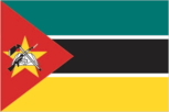
Flag
three equal horizontal bands of green (top), black, and yellow with a red isosceles triangle based on the hoist side; the black band is edged in white; centered in the triangle is a yellow five-pointed star bearing a crossed rifle and hoe in black superimposed on an open white book
Highways
total: 26,498 km paved: 4,593 km unpaved: gravel, crushed stone, stabilized earth 829 km; unimproved earth 21,076 km
Imports
$1.03 billion (c.i.f., 1993 est.) commodities: food, clothing, farm equipment, petroleum partners: US, Western Europe, USSR
Independence
25 June 1975 (from Portugal)
Industrial production
growth rate 5% (1989 est.)
Industries
food, beverages, chemicals (fertilizer, soap, paints), petroleum products, textiles, nonmetallic mineral products (cement, glass, asbestos), tobacco
Infant mortality rate
128.7 deaths/1,000 live births (1994 est.)
Inflation rate (consumer prices)
40% (1993 est.)
Inland waterways
about 3,750 km of navigable routes
International disputes
none
Irrigated land
1,150 sq km (1989 est.)
Judicial branch
Supreme Court
Labor force
NA by occupation: 90% engaged in agriculture
Land boundaries
total 4,571 km, Malawi 1,569 km, South Africa 491 km, Swaziland 105 km, Tanzania 756 km, Zambia 419 km, Zimbabwe 1,231 km
Land use
arable land: 4% permanent crops: 0% meadows and pastures: 56% forest and woodland: 20% other: 20%
Languages
Portuguese (official), indigenous dialects
Legal system
based on Portuguese civil law system and customary law
Legislative branch
unicameral Assembly of the Republic (Assembleia da Republica); draft electoral law provides for periodic, direct presidential and Assembly elections
Life expectancy at birth
total population: 48.49 years male: 46.63 years female: 50.41 years (1994 est.)
Literacy
age 15 and over can read and write (1990 est.) total population: 33% male: 45% female: 21%
Location
Southern Africa, bordering the Mozambique Channel between South Africa and Tanzania opposite the island of Madagascar
Manpower availability
males age 15-49 3,890,532; fit for military service 2,233,824
Map references
Africa, Standard Time Zones of the World
Maritime claims
exclusive economic zone: 200 nm territorial sea: 12 nm
Member of
ACP, AfDB, CCC, ECA, FAO, FLS, G-77, GATT, IBRD, ICAO, IDA, IFAD, IFC, ILO, IMF, INMARSAT, IMO, INTELSAT, INTERPOL, IOC, ITU, LORCS, NAM, OAU, OIC, SADC, UN, UNCTAD, UNESCO, UNIDO, UPU, WHO, WMO
Merchant marine
4 cargo ships (1,000 GRT or over) totaling 5,686 GRT/9,742 DWT
Names
conventional long form: Republic of Mozambique conventional short form: Mozambique local long form: Republica Popular de Mocambique local short form: Mocambique
National holiday
Independence Day, 25 June (1975)
National product
GDP - purchasing power equivalent - $9.8 billion (1993 est.)
National product per capita
$600 (1993 est.)
National product real growth rate
4.1% (1993 est.)
Nationality
noun: Mozambican(s) adjective: Mozambican
Natural resources
coal, titanium
Net migration rate
30.1 migrant(s)/1,000 population (1994 est.)
Overview
One of Africa's poorest countries, Mozambique has failed to exploit the economic potential of its sizable agricultural, hydropower, and transportation resources. Indeed, national output, consumption, and investment declined throughout the first half of the 1980s because of internal disorders, lack of government administrative control, and a growing foreign debt. A sharp increase in foreign aid, attracted by an economic reform policy, resulted in successive years of economic growth in the late 1980s, but aid has declined steadily since 1989. Agricultural output is at only 75% of its 1981 level, and grain has to be imported. Industry operates at only 20-40% of capacity. The economy depends heavily on foreign assistance to keep afloat. Peace accords signed in October 1992 improved chances of foreign investment, aided IMF-supported economic reforms, and supported continued economic recovery.
Pipelines
crude oil (not operating) 306 km; petroleum products 289 km
Political parties and leaders
Front for the Liberation of Mozambique (FRELIMO), Joaquim Alberto CHISSANO, chairman; formerly a Marxist organization with close ties to the USSR; FRELIMO was the only legal party before 30 November 1990, when the new Constitution went into effect establishing a multiparty system note: under the terms of the 1992 peace accords multiparty elections are scheduled for October 1994; 11 parties, including the Mozambique National Resistance (RENAMO), Alfonso DHLAKAMA, president, are registered to participate
Population
17,346,280 (July 1994 est.)
Population growth rate
5.87% (1994 est.)
Ports
Maputo, Beira, Nacala
Railroads
3,288 km total; 3,140 km 1.067-meter gauge; 148 km 0.762-meter narrow gauge; Malawi-Nacala, Malawi-Beira, and Zimbabwe-Maputo lines are subject to closure because of insurgency
Religions
indigenous beliefs 60%, Christian 30%, Muslim 10%
Suffrage
18 years of age; universal
Telecommunications
fair system of troposcatter, open-wire lines, and radio relay; broadcast stations - 29 AM, 4 FM, 1 TV; earth stations - 2 Atlantic Ocean INTELSAT and 3 domestic Indian Ocean INTELSAT
Terrain
mostly coastal lowlands, uplands in center, high plateaus in northwest, mountains in west
Total fertility rate
6.25 children born/woman (1994 est.)
Type
republic
Unemployment rate
50% (1989 est.)
US diplomatic representation
chief of mission: Ambassador Dennis JETT embassy: Avenida Kenneth Kuanda, 193 Maputo mailing address: P. O. Box 783, Maputo telephone: [258] (1) 49-27-97