2016 Edition
CIA World Factbook 2016 Archive (HTML)
Introduction
Background
The Caroline Islands are a widely scattered archipelago in the western Pacific Ocean; they became part of a UN Trust Territory under US administration following World War II. The eastern four island groups adopted a constitution in 1979 and chose to become the Federated States of Micronesia. (The westernmost island group became Palau.) Independence came in 1986 under a Compact of Free Association with the US, which was amended and renewed in 2004. Present concerns include large-scale unemployment, overfishing, overdependence on US foreign aid, and state perception of inequitable allocation of US aid.
Geography
Area
- 702 sq km 702 sq km 0 sq km (fresh water only) includes Pohnpei (Ponape), Chuuk (Truk) Islands, Yap Islands, and Kosrae (Kosaie)
- land
- 702 sq km
- note
- includes Pohnpei (Ponape), Chuuk (Truk) Islands, Yap Islands, and Kosrae (Kosaie)
- total
- 702 sq km
- water
- 0 sq km (fresh water only)
Area - comparative
four times the size of Washington, DC (land area only)
Climate
tropical; heavy year-round rainfall, especially in the eastern islands; located on southern edge of the typhoon belt with occasionally severe damage
Coastline
6,112 km
Elevation
- NA lowest point: Pacific Ocean 0 m highest point: Dolohmwar (Totolom) 791 m
- elevation extremes
- lowest point: Pacific Ocean 0 m
- highest point
- Dolohmwar (Totolom) 791 m
- mean elevation
- NA
Environment - current issues
overfishing, climate change, pollution
Environment - international agreements
- Biodiversity, Climate Change, Climate Change-Kyoto Protocol, Desertification, Hazardous Wastes, Law of the Sea, Ozone Layer Protection none of the selected agreements
- party to
- Biodiversity, Climate Change, Climate Change-Kyoto Protocol, Desertification, Hazardous Wastes, Law of the Sea, Ozone Layer Protection
- signed, but not ratified
- none of the selected agreements
Geographic coordinates
6 55 N, 158 15 E
Geography - note
composed of four major island groups totaling 607 islands
Irrigated land
0 sq km NA (2012)
Land boundaries
0 km
Land use
- 25.5% arable land 2.3%; permanent crops 19.7%; permanent pasture 3.5% 74.5% 0% (2011 est.)
- agricultural land
- 25.5%
- forest
- 74.5%
- other
- 0% (2011 est.)
Location
Oceania, island group in the North Pacific Ocean, about three-quarters of the way from Hawaii to Indonesia
Map references
Oceania
Maritime claims
- 12 nm 200 nm
- exclusive economic zone
- 200 nm
- territorial sea
- 12 nm
Natural hazards
typhoons (June to December)
Natural resources
timber, marine products, deep-seabed minerals, phosphate
Terrain
islands vary geologically from high mountainous islands to low, coral atolls; volcanic outcroppings on Pohnpei, Kosrae, and Chuuk
People and Society
Age structure
- 30.81% (male 16,401/female 15,863) 19.8% (male 10,406/female 10,326) 38.8% (male 19,667/female 20,966) 6.87% (male 3,532/female 3,659) 3.72% (male 1,753/female 2,146) (2016 est.)
- 0-14 years
- 30.81% (male 16,401/female 15,863)
- 15-24 years
- 19.8% (male 10,406/female 10,326)
- 25-54 years
- 38.8% (male 19,667/female 20,966)
- 55-64 years
- 6.87% (male 3,532/female 3,659)
- 65 years and over
- 3.72% (male 1,753/female 2,146) (2016 est.)
Birth rate
20.3 births/1,000 population (2016 est.)
Death rate
4.2 deaths/1,000 population (2016 est.)
Dependency ratios
- 62.4% 55.3% 7.1% 14.1% (2015 est.)
- elderly dependency ratio
- 7.1%
- potential support ratio
- 14.1% (2015 est.)
- total dependency ratio
- 62.4%
- youth dependency ratio
- 55.3%
Drinking water source
- urban: 94.8% of population rural: 87.4% of population total: 89% of population urban: 5.2% of population rural: 12.6% of population total: 11% of population (2015 est.)
- rural
- 12.6% of population
- total
- 11% of population (2015 est.)
- urban
- 5.2% of population
Education expenditures
NA
Ethnic groups
Chuukese/Mortlockese 49.3%, Pohnpeian 29.8%, Kosraean 6.3%, Yapese 5.7%, Yap outer islanders 5.1%, Polynesian 1.6%, Asian 1.4%, other 0.8% (2010 est.)
Health expenditures
13.7% of GDP (2014)
HIV/AIDS - adult prevalence rate
NA
HIV/AIDS - deaths
NA
HIV/AIDS - people living with HIV/AIDS
NA
Hospital bed density
3.2 beds/1,000 population (2009)
Infant mortality rate
- 20.5 deaths/1,000 live births 22.7 deaths/1,000 live births 18.1 deaths/1,000 live births (2016 est.)
- female
- 18.1 deaths/1,000 live births (2016 est.)
- male
- 22.7 deaths/1,000 live births
- total
- 20.5 deaths/1,000 live births
Languages
English (official and common language), Chuukese, Kosrean, Pohnpeian, Yapese, Ulithian, Woleaian, Nukuoro, Kapingamarangi
Life expectancy at birth
- 72.9 years 70.8 years 75 years (2016 est.)
- female
- 75 years (2016 est.)
- male
- 70.8 years
- total population
- 72.9 years
Major infectious diseases
- active local transmission of Zika virus by Aedes species mosquitoes has been identified in this country (as of August 2016); it poses an important risk (a large number of cases possible) among US citizens if bitten by an infective mosquito; other less common ways to get Zika are through sex, via blood transfusion, or during pregnancy, in which the pregnant woman passes Zika virus to her fetus (2016)
- note
- active local transmission of Zika virus by Aedes species mosquitoes has been identified in this country (as of August 2016); it poses an important risk (a large number of cases possible) among US citizens if bitten by an infective mosquito; other less common ways to get Zika are through sex, via blood transfusion, or during pregnancy, in which the pregnant woman passes Zika virus to her fetus (2016)
Major urban areas - population
PALIKIR (capital) 7,000 (2014)
Maternal mortality rate
100 deaths/100,000 live births (2015 est.)
Median age
- 24.7 years 24 years 25.3 years (2016 est.)
- 24total
- 24.7 years
- female
- 25.3 years (2016 est.)
- male
- 24 years
Nationality
- Micronesian(s) Micronesian; Chuukese, Kosraen(s), Pohnpeian(s), Yapese
- adjective
- Micronesian; Chuukese, Kosraen(s), Pohnpeian(s), Yapese
- noun
- Micronesian(s)
Net migration rate
-20.9 migrant(s)/1,000 population (2016 est.)
Obesity - adult prevalence rate
33.2% (2014)
Physicians density
0.18 physicians/1,000 population (2009)
Population
104,719 (July 2016 est.)
Population growth rate
-0.49% (2016 est.)
Religions
Roman Catholic 54.7%, Protestant 41.1% (includes Congregational 38.5%, Baptist 1.1%, Seventh Day Adventist 0.8%, Assembly of God 0.7%), Mormon 1.5%, other 1.9%, none 0.7%, unspecified 0.1% (2010 est.)
Sanitation facility access
- urban: 85.1% of population rural: 49% of population total: 57.1% of population urban: 14.9% of population rural: 51% of population total: 42.9% of population (2015 est.)
- rural
- 51% of population
- total
- 42.9% of population (2015 est.)
- urban
- 14.9% of population
Sex ratio
- 1.05 male(s)/female 1.03 male(s)/female 1.01 male(s)/female 0.94 male(s)/female 0.97 male(s)/female 0.81 male(s)/female 0.98 male(s)/female (2016 est.)
- 0-14 years
- 1.03 male(s)/female
- 15-24 years
- 1.01 male(s)/female
- 25-54 years
- 0.94 male(s)/female
- 55-64 years
- 0.97 male(s)/female
- 65 years and over
- 0.81 male(s)/female
- at birth
- 1.05 male(s)/female
- total population
- 0.98 male(s)/female (2016 est.)
Total fertility rate
2.45 children born/woman (2016 est.)
Urbanization
- 22.4% of total population (2015) 0.27% annual rate of change (2010-15 est.)
- rate of urbanization
- 0.27% annual rate of change (2010-15 est.)
- urban population
- 22.4% of total population (2015)
Government
Administrative divisions
4 states; Chuuk (Truk), Kosrae (Kosaie), Pohnpei (Ponape), Yap
Capital
- Palikir 6 55 N, 158 09 E UTC+11 (16 hours ahead of Washington, DC, during Standard Time)
- geographic coordinates
- 6 55 N, 158 09 E
- name
- Palikir
- time difference
- UTC+11 (16 hours ahead of Washington, DC, during Standard Time)
Citizenship
- no at least one parent must be a citizen of FSM no 5 years
- citizenship by birth
- no
- citizenship by descent only
- at least one parent must be a citizen of FSM
- dual citizenship recognized
- no
- residency requirement for naturalization
- 5 years
Constitution
drafted June 1975, ratified 1 October 1978, entered into force 10 May 1979; amended 1990; note - in 2001, all 26 amendments proposed by the FSM constitutional convention were defeated in a national referendum (2016)
Country name
- Federated States of Micronesia none Federated States of Micronesia none Trust Territory of the Pacific Islands, Ponape, Truk, and Yap Districts FSM the term "Micronesia" is a 19th-century construct of two Greek words, "micro" (small) and "nesoi" (islands), and refers to thousands of small islands in the western Pacific Ocean
- abbreviation
- FSM
- conventional long form
- Federated States of Micronesia
- conventional short form
- none
- etymology
- the term "Micronesia" is a 19th-century construct of two Greek words, "micro" (small) and "nesoi" (islands), and refers to thousands of small islands in the western Pacific Ocean
- former
- Trust Territory of the Pacific Islands, Ponape, Truk, and Yap Districts
- local long form
- Federated States of Micronesia
- local short form
- none
Diplomatic representation from the US
- Ambassador Dorothea-Maria (Doria) ROSEN (since 9 August 2012) 101 Upper Pics Road, Kolonia P. O. Box 1286, Kolonia, Pohnpei, 96941; U.S. Embassy in Micronesia, 4120 Kolonia Place, Washington, D.C. 20521-4120 [691] 320-2187 [691] 320-2186
- chief of mission
- Ambassador Dorothea-Maria (Doria) ROSEN (since 9 August 2012)
- embassy
- 101 Upper Pics Road, Kolonia
- FAX
- [691] 320-2186
- mailing address
- P. O. Box 1286, Kolonia, Pohnpei, 96941; U.S. Embassy in Micronesia, 4120 Kolonia Place, Washington, D.C. 20521-4120
- telephone
- [691] 320-2187
Diplomatic representation in the US
- Ambassador (vacant); Charge d'Affaires Ad interim James A. NAICH 1725 N Street NW, Washington, DC 20036 [1] (202) 223-4383 [1] (202) 223-4391 Honolulu, Tamuning (Guam)
- chancery
- 1725 N Street NW, Washington, DC 20036
- chief of mission
- Ambassador (vacant); Charge d'Affaires Ad interim James A. NAICH
- consulate(s) general
- Honolulu, Tamuning (Guam)
- FAX
- [1] (202) 223-4391
- telephone
- [1] (202) 223-4383
Executive branch
- President Peter M. CHRISTIAN (since 12 May 2015); Vice President Yosiwo P. GEORGE (since 12 May 2015); note - the president is both chief of state and head of government President Peter M. CHRISTIAN (since 12 May 2015); Vice President Yosiwo P. GEORGE (since 12 May 2015) Cabinet includes the vice president and the heads of the 8 executive departments president and vice president indirectly elected by Congress from among the 4 'at large' senators for a 4-year term (eligible for a second term); election last held on 11 May 2011 (next to be held in May 2015) Peter M. CHRISTIAN elected president by Congress; Yosiwo P. GEORGE elected vice president
- cabinet
- Cabinet includes the vice president and the heads of the 8 executive departments
- chief of state
- President Peter M. CHRISTIAN (since 12 May 2015); Vice President Yosiwo P. GEORGE (since 12 May 2015); note - the president is both chief of state and head of government
- election results
- Peter M. CHRISTIAN elected president by Congress; Yosiwo P. GEORGE elected vice president
- elections/appointments
- president and vice president indirectly elected by Congress from among the 4 'at large' senators for a 4-year term (eligible for a second term); election last held on 11 May 2011 (next to be held in May 2015)
- head of government
- President Peter M. CHRISTIAN (since 12 May 2015); Vice President Yosiwo P. GEORGE (since 12 May 2015)
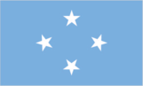
Flag description
light blue with four white five-pointed stars centered; the stars are arranged in a diamond pattern; blue symbolizes the Pacific Ocean, the stars represent the four island groups of Chuuk, Kosrae, Pohnpei, and Yap
Government type
federal republic in free association with the US
Independence
3 November 1986 (from the US-administered UN trusteeship)
International law organization participation
has not submitted an ICJ jurisdiction declaration; non-party state to the ICCt
International organization participation
ACP, ADB, AOSIS, FAO, G-77, IBRD, ICAO, ICRM, IDA, IFC, IFRCS, IMF, IOC, IOM, IPU, ITSO, ITU, MIGA, OPCW, PIF, Sparteca, SPC, UN, UNCTAD, UNESCO, WHO, WMO
Judicial branch
- Federated States of Micronesia (FSM) Supreme Court (consists of the chief justice and not more than 5 associate justices and organized into appellate and criminal divisions) justices appointed by the president of the Federated States of Micronesia with the approval of two-thirds of Congress; justices appointed for life the highest state-level courts are: Chuuk Supreme Court; Korsae State Court; Pohnpei State Court; Yap State Court
- highest court(s)
- Federated States of Micronesia (FSM) Supreme Court (consists of the chief justice and not more than 5 associate justices and organized into appellate and criminal divisions)
- judge selection and term of office
- justices appointed by the president of the Federated States of Micronesia with the approval of two-thirds of Congress; justices appointed for life
- subordinate courts
- the highest state-level courts are: Chuuk Supreme Court; Korsae State Court; Pohnpei State Court; Yap State Court
Legal system
mixed legal system of common and customary law
Legislative branch
- unicameral Congress (14 seats; 10 members directly elected in single-seat constituencies by simple majority vote to serve 2-year terms and 4 directly elected from each of the 4 states by proportional representation vote to serve 4-year terms) last held on 5 March 2013 (next to be held in March 2015) percent of vote - NA; seats - independent 14
- description
- unicameral Congress (14 seats; 10 members directly elected in single-seat constituencies by simple majority vote to serve 2-year terms and 4 directly elected from each of the 4 states by proportional representation vote to serve 4-year terms)
- election results
- percent of vote - NA; seats - independent 14
- elections
- last held on 5 March 2013 (next to be held in March 2015)
National anthem
- "Patriots of Micronesia" unknown adopted 1991; also known as "Across All Micronesia"; the music is based on the 1820 German patriotic song "Ich hab mich ergeben", which was the West German national anthem from 1949-1950; variants of this tune are used in Johannes Brahms' "Festival Overture" and Gustav Mahler's "Third Symphony"
- lyrics/music
- unknown
- name
- "Patriots of Micronesia"
- note
- adopted 1991; also known as "Across All Micronesia"; the music is based on the 1820 German patriotic song "Ich hab mich ergeben", which was the West German national anthem from 1949-1950; variants of this tune are used in Johannes Brahms' "Festival Overture" and Gustav Mahler's "Third Symphony"
National holiday
Constitution Day, 10 May (1979); Independence Day, 3 November (1986)
National symbol(s)
- four, five-pointed, white stars on a light blue field; national colors: light blue, white
- four, five-pointed, white stars on a light blue field; national colors
- light blue, white
Political parties and leaders
no formal parties
Political pressure groups and leaders
NA
Suffrage
18 years of age; universal
Economy
Agriculture - products
taro, yams, coconuts, bananas, cassava (manioc, tapioca), sakau (kava), Kosraen citrus, betel nuts, black pepper, fish, pigs, chickens
Budget
- $213.8 million $192.1 million (FY12/13 est.)
- expenditures
- $192.1 million (FY12/13 est.)
- revenues
- $213.8 million
Budget surplus (+) or deficit (-)
6.8% of GDP (FY12/13 est.)
Commercial bank prime lending rate
7.1% (2013 est.) 6.4% (2012 est.)
Current account balance
$3 million (2015 est.) $22 million (2014 est.)
Debt - external
$93.6 million (2013 est.) $93.5 million (2012 est.)
Distribution of family income - Gini index
61.1 (2013 est.)
Economy - overview
Economic activity consists largely of subsistence farming and fishing, and government, which employs two-thirds of the adult working population and receives funding largely - 58% in 2013 – from Compact of Free Association assistance provided by the US. The islands have few commercially valuable mineral deposits. The potential for tourism is limited by isolation, lack of adequate facilities, and limited internal air and water transportation. Under the terms of the original Compact, the US provided $1.3 billion in grants and aid from 1986 to 2001. The US and the Federated States of Micronesia (FSM) negotiated a second (amended) Compact agreement in 2002-03 that took effect in 2004. The amended Compact runs for a 20-year period to 2023; during which the US will provide roughly $2.1 billion to the FSM. The amended Compact also develops a Trust Fund for the FSM that will provide a comparable income stream beyond 2024 when Compact grants end. The country's medium-term economic outlook appears fragile because of dependence on US assistance and lackluster performance of its small and stagnant private sector.
Exchange rates
the US dollar is used
Exports
$88.3 million (2013 est.) $95.7 million (2012 est.)
Exports - commodities
fish, sakau (kava), betel nuts, black pepper
Fiscal year
1 October - 30 September
GDP - composition, by end use
- 83.5% 41.8% 24.3% 0% 26.6% -76.2% (2013 est.)
- exports of goods and services
- 26.6%
- government consumption
- 41.8%
- household consumption
- 83.5%
- imports of goods and services
- -76.2% (2013 est.)
- investment in fixed assets
- 24.3%
- investment in inventories
- 0%
GDP - composition, by sector of origin
- 26.3% 18.9% 54.8% (2013 est.)
- agriculture
- 26.3%
- industry
- 18.9%
- services
- 54.8% (2013 est.)
GDP - per capita (PPP)
- $3,000 (2015 est.) $2,900 (2014 est.) $3,100 (2013 est.) data are in 2015 US dollars
- note
- data are in 2015 US dollars
GDP - real growth rate
-0.2% (2015 est.) -3.4% (2014 est.) -3.6% (2013 est.)
GDP (official exchange rate)
$318 million (2015 est.)
GDP (purchasing power parity)
- $306 million (2015 est.) $306.5 million (2014 est.) $317.3 million (2013 est.) data are in 2013 US dollars; GDP supplemented by grant aid, averaging about $100 million annually
- note
- data are in 2013 US dollars; GDP supplemented by grant aid, averaging about $100 million annually
Household income or consumption by percentage share
- NA% NA%
- highest 10%
- NA%
- lowest 10%
- NA%
Imports
$258.5 million (2013 est.) $263.4 million (2012 est.)
Imports - commodities
food, beverages, clothing, computers, household electronics, appliances, manufactured goods, automobiles, machinery and equipment, furniture, tools
Industrial production growth rate
NA%
Industries
tourism, construction; specialized aquaculture, craft items (shell and wood)
Inflation rate (consumer prices)
-1% (2015 est.) 0.6% (2014 est.)
Labor force
37,920 (2010 est.)
Labor force - by occupation
- 0.9% 5.2% 93.9% two-thirds of the labor force are government employees (2013 est.)
- agriculture
- 0.9%
- industry
- 5.2%
- note
- two-thirds of the labor force are government employees (2013 est.)
- services
- 93.9%
Population below poverty line
26.7% (2000 est.)
Public debt
28% of GDP (2013) 27% of GDP (2012)
Reserves of foreign exchange and gold
$75.06 million (31 December 2011 est.)
Stock of broad money
$225.2 million (31 December 2013 est.)
Stock of direct foreign investment - at home
$15.8 million (2013 est.) $34.4 million (2012 est.)
Stock of domestic credit
$56.98 million (2013 est.) $56.77 million (31 December 2011 est.)
Stock of narrow money
$196 million (31 December 2013 est.)
Taxes and other revenues
67.2% of GDP (FY12/13 est.)
Unemployment rate
16.2% (2010 est.)
Energy
Carbon dioxide emissions from consumption of energy
105 Mt (2010 est.)
Crude oil - exports
0 bbl/day (2014)
Crude oil - imports
0 bbl/day (2014)
Crude oil - production
0 bbl/day (2014)
Crude oil - proved reserves
0 bbl (1 January 2014)
Electricity - consumption
178.6 million kWh (2002)
Electricity - exports
0 kWh (2013 est.)
Electricity - from fossil fuels
96% of total installed capacity (2015 est.)
Electricity - from hydroelectric plants
1% of total installed capacity (2013 est.)
Electricity - from nuclear fuels
0% of total installed capacity (2015 est.)
Electricity - from other renewable sources
3% of total installed capacity (2013 est.)
Electricity - imports
0 kWh (2013 est.)
Electricity - installed generating capacity
18,000 kW (2015 est.)
Electricity - production
192 million kWh (2002)
Electricity access
- 42,934 59% 100% 45% (2012)
- electrification - rural areas
- 45% (2012)
- electrification - total population
- 59%
- electrification - urban areas
- 100%
- population without electricity
- 42,934
Natural gas - production
0 cu m (2014)
Natural gas - proved reserves
0 cu m
Refined petroleum products - exports
0 bbl/day
Refined petroleum products - production
0 bbl/day (2014)
Communications
Broadcast media
no TV broadcast stations; each state has a multi-channel cable service with TV transmissions carrying roughly 95% imported programming and 5% local programming; about a half-dozen radio stations (2009)
Internet country code
.fm
Internet users
- 33,000 31.5% (July 2015 est.)
- percent of population
- 31.5% (July 2015 est.)
- total
- 33,000
Telephone system
- adequate system islands interconnected by shortwave radiotelephone (used mostly for government purposes), satellite (Intelsat) ground stations, and some coaxial and fiber-optic cable; mobile-cellular service available on the major islands country code - 691; satellite earth stations - 5 Intelsat (Pacific Ocean) (2015)
- domestic
- islands interconnected by shortwave radiotelephone (used mostly for government purposes), satellite (Intelsat) ground stations, and some coaxial and fiber-optic cable; mobile-cellular service available on the major islands
- general assessment
- adequate system
- international
- country code - 691; satellite earth stations - 5 Intelsat (Pacific Ocean) (2015)
Telephones - fixed lines
- 6,808 6 (July 2015 est.)
- subscriptions per 100 inhabitants
- 6 (July 2015 est.)
- total subscriptions
- 6,808
Telephones - mobile cellular
- 31,400 30 (July 2013 est.)
- subscriptions per 100 inhabitants
- 30 (July 2013 est.)
- total
- 31,400
Transportation
Airports
6 (2013)
Airports - with paved runways
- 2 (2013)
- 1,524 to 2,437 m
- 4
- 914 to 1,523 m
- 2 (2013)
- total
- 6
Civil aircraft registration country code prefix
V6 (2016)
Merchant marine
- cargo 1, passenger/cargo 2 (2010)
- by type
- cargo 1, passenger/cargo 2 (2010)
- total
- 3
Ports and terminals
- Colonia (Tamil Harbor), Lele Harbor, Pohnepi Harbor
- major seaport(s)
- Colonia (Tamil Harbor), Lele Harbor, Pohnepi Harbor
Roadways
- 388 km 184 km 204 km (2015)
- paved
- 184 km
- total
- 388 km
- unpaved
- 204 km (2015)
Military and Security
Military - note
defense is the responsibility of the US
Military branches
no regular military forces (2012)
Transnational Issues
Disputes - international
none
Illicit drugs
major consumer of cannabis