2015 Edition
CIA World Factbook 2015 Archive (Wayback Machine ZIP)
Introduction
Background
Although known to Arab and Malay sailors as early as the 10th century, Mauritius was first explored by the Portuguese in the 16th century and subsequently settled by the Dutch - who named it in honor of Prince Maurits van NASSAU - in the 17th century. The French assumed control in 1715, developing the island into an important naval base overseeing Indian Ocean trade, and establishing a plantation economy of sugar cane. The British captured the island in 1810, during the Napoleonic Wars. Mauritius remained a strategically important British naval base, and later an air station, playing an important role during World War II for anti-submarine and convoy operations, as well as the collection of signals intelligence. Independence from the UK was attained in 1968. A stable democracy with regular free elections and a positive human rights record, the country has attracted considerable foreign investment and has one of Africa's highest per capita incomes.
Geography
Area
- land
- 2,030 sq km
- note
- includes Agalega Islands, Cargados Carajos Shoals (Saint Brandon), and Rodrigues
- total
- 2,040 sq km
- water
- 10 sq km
Area - comparative
almost 11 times the size of Washington, DC
Climate
tropical, modified by southeast trade winds; warm, dry winter (May to November); hot, wet, humid summer (November to May)
Coastline
177 km
Elevation extremes
- highest point
- Mont Piton 828 m
- lowest point
- Indian Ocean 0 m
Environment - current issues
water pollution, degradation of coral reefs
Environment - international agreements
- party to
- Antarctic-Marine Living Resources, Biodiversity, Climate Change, Climate Change-Kyoto Protocol, Desertification, Endangered Species, Environmental Modification, Hazardous Wastes, Law of the Sea, Marine Life Conservation, Ozone Layer Protection, Ship Pollution, Wetlands
- signed, but not ratified
- none of the selected agreements
Freshwater withdrawal (domestic/industrial/agricultural)
- per capita
- 568.2 cu m/yr (2003)
- total
- 0.73 cu km/yr (30%/3%/68%)
Geographic coordinates
20 17 S, 57 33 E
Geography - note
the main island, from which the country derives its name, is of volcanic origin and is almost entirely surrounded by coral reefs; former home of the dodo, a large flightless bird related to pigeons, driven to extinction by the end of the 17th century through a combination of hunting and the introduction of predatory species
Irrigated land
212.2 sq km (2003)
Land boundaries
0 km
Land use
- arable land 38.4%; permanent crops 2%; permanent pasture 3.4%
- agricultural land
- 43.8%
- forest
- 17.3%
- other
- 38.9% (2011 est.)
Location
Southern Africa, island in the Indian Ocean, about 800 km (500 mi) east of Madagascar
Map references
Africa
Maritime claims
- measured from claimed archipelagic straight baselines
- continental shelf
- 200 nm or to the edge of the continental margin
- exclusive economic zone
- 200 nm
- territorial sea
- 12 nm
Natural hazards
cyclones (November to April); almost completely surrounded by reefs that may pose maritime hazards
Natural resources
arable land, fish
Terrain
small coastal plain rising to discontinuous mountains encircling central plateau
Total renewable water resources
2.75 cu km (2011)
People and Society
Age structure
- 0-14 years
- 20.74% (male 141,928/female 135,918)
- 15-24 years
- 15.3% (male 103,549/female 101,469)
- 25-54 years
- 44% (male 294,700/female 294,863)
- 55-64 years
- 11.15% (male 70,810/female 78,599)
- 65 years and over
- 8.81% (male 47,900/female 70,091) (2015 est.)
Birth rate
13.29 births/1,000 population (2015 est.)
Death rate
6.91 deaths/1,000 population (2015 est.)
Dependency ratios
- elderly dependency ratio
- 13.4%
- potential support ratio
- 7.4% (2015 est.)
- total dependency ratio
- 40.6%
- youth dependency ratio
- 27.2%
Drinking water source
- urban: 99.9% of population
- rural: 99.8% of population
- total: 99.9% of population
- urban: 0.1% of population
- rural: 0.2% of population
- total: 0.1% of population (2015 est.)
Education expenditures
3.7% of GDP (2013)
Ethnic groups
Indo-Mauritian 68%, Creole 27%, Sino-Mauritian 3%, Franco-Mauritian 2%
Health expenditures
4.8% of GDP (2013)
HIV/AIDS - adult prevalence rate
0.92% (2014 est.)
HIV/AIDS - deaths
500 (2014 est.)
HIV/AIDS - people living with HIV/AIDS
8,300 (2014 est.)
Hospital bed density
3.4 beds/1,000 population (2011)
Infant mortality rate
- female
- 8.26 deaths/1,000 live births (2015 est.)
- male
- 12.24 deaths/1,000 live births
- total
- 10.3 deaths/1,000 live births
Languages
Creole 86.5%, Bhojpuri 5.3%, French 4.1%, two languages 1.4%, other 2.6% (includes English, the official language, which is spoken by less than 1% of the population), unspecified 0.1% (2011 est.)
Life expectancy at birth
- female
- 79.03 years (2015 est.)
- male
- 71.94 years
- total population
- 75.4 years
Literacy
- definition
- age 15 and over can read and write
- female
- 88.5% (2015 est.)
- male
- 92.9%
- total population
- 90.6%
Major urban areas - population
PORT LOUIS (capital) 135,000 (2014)
Median age
- female
- 35.3 years (2015 est.)
- male
- 33.5 years
- total
- 34.4 years
Nationality
- adjective
- Mauritian
- noun
- Mauritian(s)
Net migration rate
0 migrant(s)/1,000 population (2015 est.)
Obesity - adult prevalence rate
18.8% (2014)
Physicians density
1.62 physicians/1,000 population (2013)
Population
1,339,827 (July 2015 est.)
Population growth rate
0.64% (2015 est.)
Religions
Hindu 48.5%, Roman Catholic 26.3%, Muslim 17.3%, other Christian 6.4%, other 0.6%, none 0.7%, unspecified 0.1% (2011 est.)
Sanitation facility access
- urban: 93.9% of population
- rural: 92.6% of population
- total: 93.1% of population
- urban: 6.1% of population
- rural: 7.4% of population
- total: 6.9% of population (2015 est.)
School life expectancy (primary to tertiary education)
- female
- 16 years (2012)
- male
- 15 years
- total
- 16 years
Sex ratio
- 0-14 years
- 1.04 male(s)/female
- 15-24 years
- 1.02 male(s)/female
- 25-54 years
- 1 male(s)/female
- 55-64 years
- 0.9 male(s)/female
- 65 years and over
- 0.68 male(s)/female
- at birth
- 1.05 male(s)/female
- total population
- 0.97 male(s)/female (2015 est.)
Total fertility rate
1.76 children born/woman (2015 est.)
Unemployment, youth ages 15-24
- female
- 28.4% (2012 est.)
- male
- 20.4%
- total
- 23.7%
Urbanization
- rate of urbanization
- -0.08% annual rate of change (2010-15 est.)
- urban population
- 39.7% of total population (2015)
Government
Administrative divisions
9 districts and 3 dependencies*; Agalega Islands*, Black River, Cargados Carajos Shoals*, Flacq, Grand Port, Moka, Pamplemousses, Plaines Wilhems, Port Louis, Riviere du Rempart, Rodrigues*, Savanne
Capital
- geographic coordinates
- 20 09 S, 57 29 E
- name
- Port Louis
- time difference
- UTC+4 (9 hours ahead of Washington, DC, during Standard Time)
Constitution
several previous; latest adopted 12 March 1968; amended many times, last in 2012 (2012)
Country name
- conventional long form
- Republic of Mauritius
- conventional short form
- Mauritius
- local long form
- Republic of Mauritius
- local short form
- Mauritius
- note
- island named after Prince Maurice VAN NASSAU, stadtholder of the Dutch Republic, in 1598
Diplomatic representation from the US
- chief of mission
- Ambassador Shari VILLAROSA (since 5 November 2012); note - also accredited to Seychelles
- embassy
- 4th Floor, Rogers House, John Kennedy Street, Port Louis
- FAX
- [230] 208-9534
- mailing address
- international mail: P. O. Box 544, Port Louis; US mail: American Embassy, Port Louis, US Department of State, Washington, DC 20521-2450
- telephone
- [230] 202-4400
Diplomatic representation in the US
- chancery
- 1709 N Street NW, Washington, DC 20036; administrative offices at 3201 Connecticut Avenue NW, Suite 441, Washington, DC 20036
- chief of mission
- Ambassador Sooroojdev PHOKEER (since 3 August 2015)
- FAX
- [1] (202) 966-0983
- telephone
- [1] (202) 244-1491 through 1492
Executive branch
- cabinet
- Council of Ministers appointed by the president on the recommendation of the prime minister
- chief of state
- President Ameenah GURIB-FAKIM (since 5 June 2015); Vice President Monique OHSAN-BELLEPEAU (since 12 November 2010)
- election results
- Ameenah GURIB-FAKIM (independent) elected president by the National Assembly - unanimous vote
- elections/appointments
- president and vice president indirectly elected by the National Assembly for a 5-year term (eligible for a second term); election last held on 4 June 2015 (next to be held in 2020); prime minister and deputy prime minister appointed by the president, responsible to the National Assembly
- head of government
- Prime Minister Sir Anerood JUGNAUTH (since 17 December 2014)
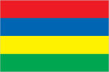
Flag description
four equal horizontal bands of red (top), blue, yellow, and green; red represents self-determination and independence, blue the Indian Ocean surrounding the island, yellow has been interpreted as the new light of independence, golden sunshine, or the bright future, and green can symbolize either agriculture or the lush vegetation of the island
Government type
parliamentary democracy
Independence
12 March 1968 (from the UK)
International law organization participation
accepts compulsory ICJ jurisdiction with reservations; accepts ICCt jurisdiction
International organization participation
ACP, AfDB, AOSIS, AU, C, CD, COMESA, CPLP (associate), FAO, G-77, IAEA, IBRD, ICAO, ICC (NGOs), ICCt, ICRM, IDA, IFAD, IFC, IFRCS, IHO, ILO, IMF, IMO, IMSO, InOC, Interpol, IOC, IOM, IPU, ISO, ITSO, ITU, ITUC (NGOs), MIGA, NAM, OIF, OPCW, PCA, SAARC (observer), SADC, UN, UNCTAD, UNESCO, UNIDO, UNWTO, UPU, WCO, WFTU (NGOs), WHO, WIPO, WMO, WTO
Judicial branch
- highest court(s)
- Supreme Court of Mauritius (consists of the chief justice, a senior puisne judge, and 17 puisne judges); note - the Judicial Committee of the Privy Council (in London) serves as the final court of appeal
- judge selection and term of office
- chief justice appointed by the president after consultation with the prime minister; senior puisne judge appointed by the president with the advice of the chief justice; other puisne judges appointed by the president with the advice of the Judicial and Legal Commission, a 4-member body of judicial officials including the chief justice; all judges serve until retirement at age 62
- subordinate courts
- Court of Civil Appeal; Court of Criminal Appeal; Public Bodies Appeal Tribunal (formed by a 2008 constitutional amendment)
Legal system
civil legal system based on French civil law with some elements of English common law
Legislative branch
- description
- unicameral National Assembly or Assemblee Nationale (70 seats maximum; 62 members directly elected in single- and multi-seat constituencies by simple majority vote and up to 8 seats allocated to non-elected party candidates by the Electoral Commissioner's Office to ensure fair and adequate representation of each community and party in the Assembly; members serve 5-year terms)
- election results
- percent of vote by party - Alliance Lepep 49.8%, PTR-MMM 38.5%, FSM 2.1%, OPR 1.1%, other 8.5%; elected seats by party - Alliance Lepep 47, PTR-MMM 13, OPR 2; appointed seats Alliance Lepep 4, PTR-MMM 3, unassigned 1
- elections
- last held on 10 December 2014 (next to be held by 2019); note - the National Assembly was dissolved on 6 October 2014, resulting in early elections
National anthem
- lyrics/music
- Jean Georges PROSPER/Philippe GENTIL
- name
- "Motherland"
- note
- adopted 1968
National holiday
Independence Day, 12 March (1968)
National symbol(s)
dodo bird; national colors: red, blue, yellow, green
Political parties and leaders
- Alliance Lepep (Alliance of the People) [Sir Anerood JUGNAUTH] (coalition including MSM, PMSD, and ML)
- Labor Party (Parti Travailliste) or PTR or MLP [Navinchandra RAMGOOLAM]
- Mauritian Militant Movement (Mouvement Militant Mauricien) or MMM [Paul BERENGER]
- Mauritian Social Democratic Party (Parti Mauricien Social Democrate) or PMSD [Xavier Luc DUVAL]
- Mauritian Solidarity Front (Front Solidarite Mauricienne) or FSM [Cehi FAKEERMEEAH]
- Militant Socialist Movement (Mouvement Socialist Mauricien) or MSM [Pravind JUGNAUTH]
- Muvman Liberator or ML [Ivan COLLENDAVELLOO]
- PTR-MMM Coalition [Navinchandra RAMGOOLAM] (coalition including PTR and MMM)
- Rodrigues Peoples Organization (Organisation du Peuple Rodriguais) or OPR [Serge CLAIR]
Political pressure groups and leaders
- Lalit Political Party
- Say No to Coal!
- other
- various labor unions
Suffrage
18 years of age; universal
Economy
Agriculture - products
sugarcane, tea, corn, potatoes, bananas, pulses; cattle, goats; fish
Budget
- expenditures
- $3.263 billion (2014 est.)
- revenues
- $2.797 billion
Budget surplus (+) or deficit (-)
-3.7% of GDP (2014 est.)
Central bank discount rate
9% (31 December 2010)
Commercial bank prime lending rate
- 8.7% (31 December 2014 est.)
- 8.5% (31 December 2013 est.)
Current account balance
- -$956 million (2014 est.)
- -$1.179 billion (2013 est.)
Debt - external
- $5.7 billion (31 December 2014 est.)
- $5.229 billion (31 December 2013 est.)
Distribution of family income - Gini index
- 35.9 (2012 est.)
- 39 (2006 est.)
Economy - overview
Since independence in 1968, Mauritius has undergone a remarkable economic transformation from a low-income, agriculturally based economy to a diversified, upper middle-income economy with growing industrial, financial, and tourist sectors. Mauritius has achieved steady growth over the last several decades, resulting in more equitable income distribution, increased life expectancy, lowered infant mortality, and a much-improved infrastructure. The economy rests on sugar, tourism, textiles and apparel, and financial services, and is expanding into fish processing, information and communications technology, and hospitality and property development. Sugarcane is grown on about 90% of the cultivated land area and accounts for 15% of export earnings. The government's development strategy centers on creating vertical and horizontal clusters of development in these sectors. Mauritius has attracted more than 32,000 offshore entities, many aimed at commerce in India, South Africa, and China. Investment in the banking sector alone has reached over $1 billion. Mauritius’ textile sector has taken advantage of the Africa Growth and Opportunity Act, with Mauritian exports to the US growing by 400% from 2001-2012. Mauritius' sound economic policies and prudent banking practices helped to mitigate negative effects of the global financial crisis in 2008-09. GDP grew in the 3-4% per year range in 2010-14, and the country continues to expand its trade and investment outreach around the globe.
Exchange rates
- Mauritian rupees (MUR) per US dollar -
- 30.43 (2014 est.)
- 30.703 (2013 est.)
- 30.05 (2012 est.)
- 28.706 (2011 est.)
- 30.784 (2010 est.)
Exports
- $3.135 billion (2014 est.)
- $2.872 billion (2013 est.)
Exports - commodities
clothing and textiles, sugar, cut flowers, molasses, fish, primates (for research)
Exports - partners
France 14.6%, UK 13.8%, UAE 10.6%, US 10.5%, South Africa 7.1%, Italy 6.6%, Madagascar 6.5%, Spain 5.2% (2014)
Fiscal year
1 July - 30 June
GDP - composition, by end use
- (2014 est.)
- exports of goods and services
- 55.4%
- government consumption
- 14.4%
- household consumption
- 73.4%
- imports of goods and services
- -67.2%
- investment in fixed capital
- 21.2%
- investment in inventories
- 2.8%
GDP - composition, by sector of origin
- agriculture
- 4.5%
- industry
- 22.4%
- services
- 73.2% (2014 est.)
GDP - per capita (PPP)
- $18,600 (2014 est.)
- $18,000 (2013 est.)
- $17,400 (2012 est.)
- note
- data are in 2014 US dollars
GDP - real growth rate
- 3.2% (2014 est.)
- 3.2% (2013 est.)
- 3.2% (2012 est.)
GDP (official exchange rate)
$13.24 billion (2014 est.)
GDP (purchasing power parity)
- $23.36 billion (2014 est.)
- $22.62 billion (2013 est.)
- $21.92 billion (2012 est.)
- note
- data are in 2014 US dollars
Gross national saving
- 14.8% of GDP (2014 est.)
- 15.1% of GDP (2013 est.)
- 18.4% of GDP (2012 est.)
Household income or consumption by percentage share
- highest 10%
- NA%
- lowest 10%
- NA%
Imports
- $5.441 billion (2014 est.)
- $5.141 billion (2013 est.)
Imports - commodities
manufactured goods, capital equipment, foodstuffs, petroleum products, chemicals
Imports - partners
India 21.7%, China 16.2%, France 7.8%, South Africa 6.6% (2014)
Industrial production growth rate
0.4% (2014 est.)
Industries
food processing (largely sugar milling), textiles, clothing, mining, chemicals, metal products, transport equipment, nonelectrical machinery, tourism
Inflation rate (consumer prices)
- 3% (2014 est.)
- 3.5% (2013 est.)
Labor force
600,200 (2014 est.)
Labor force - by occupation
- agriculture and fishing
- 9%
- construction and industry
- 30%
- finance
- 6%
- other services
- 25% (2007)
- trade, restaurants, hotels
- 22%
- transportation and communication
- 7%
Market value of publicly traded shares
- $7.093 billion (31 December 2012 est.)
- $7.667 billion (31 December 2011)
- $7.442 billion (31 December 2010 est.)
Population below poverty line
8% (2006 est.)
Public debt
- 61.4% of GDP (2014 est.)
- 60% of GDP (2013 est.)
Reserves of foreign exchange and gold
- $4.018 billion (31 December 2014 est.)
- $3.491 billion (31 December 2013 est.)
Stock of broad money
- $12.6 billion (31 December 2014 est.)
- $12.15 billion (31 December 2013 est.)
Stock of direct foreign investment - abroad
$NA
Stock of direct foreign investment - at home
NA
Stock of domestic credit
- $16.27 billion (31 December 2014 est.)
- $14.9 billion (31 December 2013 est.)
Stock of narrow money
- $2.666 billion (31 December 2014 est.)
- $2.562 billion (31 December 2013 est.)
Taxes and other revenues
22% of GDP (2014 est.)
Unemployment rate
- 7.8% (2014 est.)
- 8% (2013 est.)
Energy
Carbon dioxide emissions from consumption of energy
5.317 million Mt (2012 est.)
Crude oil - exports
0 bbl/day (2010 est.)
Crude oil - imports
0 bbl/day (2010 est.)
Crude oil - production
0 bbl/day (2013 est.)
Crude oil - proved reserves
0 bbl (1 January 2014 est.)
Electricity - consumption
2.658 billion kWh (2013 est.)
Electricity - exports
0 kWh (2013 est.)
Electricity - from fossil fuels
96.5% of total installed capacity (2013 est.)
Electricity - from hydroelectric plants
3.3% of total installed capacity (2013 est.)
Electricity - from nuclear fuels
0% of total installed capacity (2013 est.)
Electricity - from other renewable sources
0.2% of total installed capacity (2013 est.)
Electricity - imports
0 kWh (2013 est.)
Electricity - installed generating capacity
778,200 kW (2013 est.)
Electricity - production
2.885 billion kWh (2013 est.)
Natural gas - consumption
0 cu m (2012 est.)
Natural gas - exports
0 cu m (2012 est.)
Natural gas - imports
0 cu m (2012 est.)
Natural gas - production
0 cu m (2012 est.)
Natural gas - proved reserves
0 cu m (1 January 2014 est.)
Refined petroleum products - consumption
25,430 bbl/day (2013 est.)
Refined petroleum products - exports
0 bbl/day (2010 est.)
Refined petroleum products - imports
20,620 bbl/day (2010 est.)
Refined petroleum products - production
0 bbl/day (2010 est.)
Communications
Broadcast media
the government maintains control over TV broadcasting through the Mauritius Broadcasting Corporation (MBC), which operates 3 analog and 10 digital TV stations; MBC is a shareholder in a local company that operates 2 pay-TV stations; the state retains the largest radio broadcast network with multiple stations; several private radio broadcasters have entered the market since 2001; transmissions of at least 2 international broadcasters are available (2007)
Internet country code
.mu
Internet users
- percent of population
- 6.1% (2014 est.)
- total
- 81,700
Radio broadcast stations
AM 4, FM 9, shortwave 0 (2001)
Telephone system
- domestic
- monopoly over fixed-line services terminated in 2005; fixed-line teledensity roughly 30 per 100 persons; mobile-cellular services launched in 1989 with current teledensity roughly 100 per 100 persons
- general assessment
- small system with good service
- international
- country code - 230; landing point for the SAFE submarine cable that provides links to Asia and South Africa where it connects to the SAT-3/WASC submarine cable that provides further links to parts of East Africa, and Europe; satellite earth station - 1 Intelsat (Indian Ocean); new microwave link to Reunion; HF radiotelephone links to several countries (2011)
Telephones - fixed lines
- subscriptions per 100 inhabitants
- 28 (2014 est.)
- total subscriptions
- 370,000
Telephones - mobile cellular
- subscriptions per 100 inhabitants
- 124 (2014 est.)
- total
- 1.7 million
Television broadcast stations
2 (plus several repeaters) (1997)
Transportation
Airports
5 (2013)
Airports - with paved runways
- 914 to 1,523 m
- 1 (2013)
- over 3,047 m
- 1
- total
- 2
Airports - with unpaved runways
- 1 (2013)
- 914 to 1,523 m
- 2
- total
- 3
Merchant marine
- by type
- passenger/cargo 2, petroleum tanker 1, refrigerated cargo 1 (2010)
- total
- 4
Ports and terminals
- major seaport(s)
- Port Louis
Roadways
- paved
- 2,149 km (includes 75 km of expressways) (2012)
- total
- 2,149 km
Military and Security
Manpower available for military service
- males age 16-49
- 343,628 (2010 est.)
Manpower fit for military service
- females age 16-49
- 283,317 (2010 est.)
- males age 16-49
- 280,596
Manpower reaching militarily significant age annually
- female
- 10,104 (2010 est.)
- male
- 10,193
Military branches
no regular military forces; Mauritius Police Force, Special Mobile Force, National Coast Guard (2011)
Military expenditures
- 0.19% of GDP (2012)
- 0.16% of GDP (2011)
- 0.19% of GDP (2010)
Transnational Issues
Disputes - international
Mauritius and Seychelles claim the Chagos Islands; claims French-administered Tromelin Island
Illicit drugs
consumer and transshipment point for heroin from South Asia; small amounts of cannabis produced and consumed locally; significant offshore financial industry creates potential for money laundering, but corruption levels are relatively low and the government appears generally to be committed to regulating its banking industry