1992 Edition
CIA World Factbook 1992 (Project Gutenberg)
Geography
Climate
desert; constantly hot, dry, dusty
Coastline
754 km
Comparative area
slightly larger than three times the size of New Mexico
Continental shelf
edge of continental margin or 200 nm
Disputes
boundary with Senegal
Environment
hot, dry, dust/sand-laden sirocco wind blows primarily in March and April; desertification; only perennial river is the Senegal
Exclusive economic zone
200 nm
Land area
1,030,400 km2
Land boundaries
5,074 km; Algeria 463 km, Mali 2,237 km, Senegal 813 km, Western Sahara 1,561 km
Land use
arable land 1%; permanent crops NEGL%; meadows and pastures 38%; forest and woodland 5%; other 56%; includes irrigated NEGL%
Natural resources
iron ore, gypsum, fish, copper, phosphate
Terrain
mostly barren, flat plains of the Sahara; some central hills
Territorial sea
12 nm
Total area
1,030,700 km2
People and Society
Birth rate
48 births/1,000 population (1992)
Death rate
17 deaths/1,000 population (1992)
Ethnic divisions
mixed Maur/black 40%, Maur 30%, black 30%
Infant mortality rate
89 deaths/1,000 live births (1992)
Labor force
465,000 (1981 est.); 45,000 wage earners (1980); agriculture 47%, services 29%, industry and commerce 14%, government 10%; 53% of population of working age (1985)
Languages
Hasaniya Arabic (official); Hasaniya Arabic, Pular, Soninke, Wolof (official)
Life expectancy at birth
44 years male, 50 years female (1992)
Literacy
34% (male 47%, female 21%) age 10 and over can read and write (1990 est.)
Nationality
noun - Mauritanian(s); adjective - Mauritanian
Net migration rate
0 migrants/1,000 population (1992)
Organized labor
30,000 members claimed by single union, Mauritanian Workers' Union
Population
2,059,187 (July 1992), growth rate 3.1% (1992)
Religions
Muslim, nearly 100%
Total fertility rate
7.1 children born/woman (1992)
Government
Administrative divisions
12 regions(regions, singular - region); Adrar, Assaba, Brakna, Dakhlet Nouadhibou, Gorgol, Guidimaka, Hodh ech Chargui, Hodh el Gharbi, Inchiri, Tagant, Tiris Zemmour, Trarza; note - there may be a new capital district of Nouakchott
Capital
Nouakchott
Chief of State and Head of Government
President Col. Maaouya Ould Sid`Ahmed TAYA (since 12 December 1984)
Constitution
currently 12 July 1991; 20 May 1961 Constitution abrogated after coup of 10 July 1978; provisional constitution published 17 December 1980 but abandoned in 1981; constitutional charter published 27 February 1985 after Taya came to power; latest constitution approved after general referendum 12 July 1991
Diplomatic representation
Ambassador Mohamed Fall OULD AININA; Chancery at 2129 Leroy Place NW, Washington, DC 20008; telephone (202) 232-5700 US: Ambassador Gordon S. BROWN; Embassy at address NA, Nouakchott (mailing address is B. P. 222, Nouakchott); telephone [222] (2) 526-60 or 526-63; FAX [222] (2) 515-92
Executive branch
president
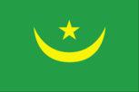
Flag
green with a yellow five-pointed star above a yellow, horizontal crescent; the closed side of the crescent is down; the crescent, star, and color green are traditional symbols of Islam
Independence
28 November 1960 (from France)
Judicial branch
Supreme Court (Cour Supreme)
Legal system
based on Islamic law
Legislative branch
National Assembly (Assemblee Nationale) and Senate
Long-form name
Islamic Republic of Mauritania
Member of
ABEDA, ACCT (associate), ACP, AfDB, AFESD, AL, AMF, AMU, CAEU, CCC, CEAO, ECA, ECOWAS, FAO, G-77, GATT, IBRD, ICAO, IDA, IDB, IFAD, IFC, ILO, IMF, IMO, INTELSAT, INTERPOL, IOC, ITU, LORCS, NAM, OAU, OIC, UN, UNCTAD, UNESCO, UNIDO, UPU, WHO, WIPO, WMO, WTO
National Assembly
last held 6 and 13 March 1992 (next to be held NA 1997)
National holiday
Independence Day, 28 November (1960)
Political parties and leaders
- legalized by constitution passed 12 July 1991; emerging parties include Democratic and Social Republican Party (PRDS), led by President Col. Maaouya Ould Sid`Ahmed TAYA; Union of Democratic Forces (UDF), coalition of seven
- AMADOU, and Messoud Ould BOULKHEIR; Assembly for Democracy (RDU), Mohamed Ould SIDI BABA; Rally for Democracy and Unity (RDUN), Mohamed Ould Sidi BABA; Popular Social and Democratic Union (UPSD), Mohamed Mahmoud Ould MAH; Progressive Popular Alliance (APP), Taleb Ould Jiddou Ould Mohamed LAGHDAF; Mauritanian Party for Renewal (PMR), Moulaye El Hassan Ould JEYID; National Avant-Garde Party (PAN or PAGN), Khattry Ould Taleb JIDDOU; Mauritanian Party of the Democratic Center (PCDM), Bamba Ould SIDI BADI; Union for Planning and Construction (UPC), Mohamed Ould EYAHA; Democratic Justice Party (PJD), Mohamed Abdallahi Ould EL BANE; Party for Liberty, Equality, and Justice (PLEJ), Ba Mamadou ALASSANE; Labor and National Unity Party (PTUN), Ali Bouna Ould OUENINA
- opposition factions, three leaders
- Mohameden Ould BABAH, Diop Mamadou
President
last held January 1992 (next to be held NA) results: President Col. Maabuya Ould Sid`Ahmed TAYA elected
Senate
last held 3 and 10 April 1992 (next to be held April 1998)
Suffrage
universal at age 18
Type
republic; military first seized power in bloodless coup 10 July 1978; a palace coup that took place on 12 December 1984 brought President Taya to power; he was elected in 1992
Economy
Agriculture
accounts for 29% of GDP (including fishing); largely subsistence farming and nomadic cattle and sheep herding except in Senegal river valley; crops - dates, millet, sorghum, root crops; fish products number-one export; large food deficit in years of drought
Budget
revenues $280 million; expenditures $346 million, including capital expenditures of $61 million (1989 est.)
Currency
ouguiya (plural - ouguiya); 1 ouguiya (UM) = 5 khoums
Economic aid
US commitments, including Ex-Im (FY70-89), $168 million; Western (non-US) countries, ODA and OOF bilateral commitments (1970-89), $1.3 billion; OPEC bilateral aid (1979-89), $490 million; Communist countries (1970-89), $277 million; Arab Development Bank (1991), $20 million
Electricity
190,000 kW capacity; 135 million kWh produced, 70 kWh per capita (1991)
Exchange rates
ouguiya (UM) per US$1 - 79.300 (January 1992), 81.946 (1991), 80.609 (1990), 83.051 (1989), 75.261 (1988), 73.878 (1987)
Exports
$436 million (f.o.b., 1990) commodities: iron ore, processed fish, small amounts of gum arabic and gypsum; unrecorded but numerically significant cattle exports to Senegal partners: EC 43%, Japan 27%, USSR 11%, Ivory Coast 3%
External debt
$1.9 billion (1990)
Fiscal year
calendar year
GDP
exchange rate conversion - $1.1 billion, per capita $535; real growth rate 3% (1991 est.)
Imports
$389 million (c.i.f., 1990) commodities: foodstuffs, consumer goods, petroleum products, capital goods partners: EC 60%, Algeria 15%, China 6%, US 3%
Industrial production
growth rate 4.4% (1988 est.); accounts for almost 20% of GDP
Industries
fishing, fish processing, mining of iron ore and gypsum
Inflation rate (consumer prices)
6.5% (1990 est.)
Overview
A majority of the population still depends on agriculture and livestock for a livelihood, even though most of the nomads and many subsistence farmers were forced into the cities by recurrent droughts in the 1970s and 1980s. Mauritania has extensive deposits of iron ore, which account for almost 50% of total exports. The decline in world demand for this ore, however, has led to cutbacks in production. The nation's coastal waters are among the richest fishing areas in the world, but overexploitation by foreigners threatens this key source of revenue. The country's first deepwater port opened near Nouakchott in 1986. In recent years, the droughts, the endemic conflict with Senegal, rising energy costs, and economic mismanagement have resulted in a substantial buildup of foreign debt. The government has begun the second stage of an economic reform program in consultation with the World Bank, the IMF, and major donor countries. But the reform process suffered a major setback following the Gulf war of early 1991. Because of Mauritania's support of Saddam Husayn, bilateral aid from its two top donors, Saudi Arabia and Kuwait, was suspended, and multilateral aid was reduced.
Unemployment rate
20% (1991 est.)
Communications
Airports
28 total, 28 usable; 9 with permanent-surface runways; none with runways over 3,659 m; 5 with runways 2,440-3,659 m; 16 with runways 1,220-2,439 m
Civil air
3 major transport aircraft
Highways
7,525 km total; 1,685 km paved; 1,040 km gravel, crushed stone, or otherwise improved; 4,800 km unimproved roads, trails, tracks
Inland waterways
mostly ferry traffic on the Senegal River
Merchant marine
1 cargo ship (1,000 GRT or over) totaling 1,290 GRT/1,840 DWT
Ports
Nouadhibou, Nouakchott
Railroads
690 km 1.435-meter (standard) gauge, single track, owned and operated by government mining company
Telecommunications
poor system of cable and open-wire lines, minor radio relay links, and radio communications stations (improvements being made); broadcast stations - 2 AM, no FM, 1 TV; satellite earth stations - 1 Atlantic Ocean INTELSAT and 2 ARABSAT, with six planned
Military and Security
Branches
Army, Navy, Air Force, National Gendarmerie, National Guard, National Police, Presidential Guard
Defense expenditures
exchange rate conversion - $40 million, 4.2% of GDP (1989)
Manpower availability
males 15-49, 436,897; 213,307 fit for military service; conscription law not implemented