1989 Edition
CIA World Factbook 1989 (Internet Archive)
Geography
Administrative divisions
1 2 regions (regions, singular — region); Adrar, Brakna, Dakhlet Nouadhibou, El 'Acaba, Gorgol, Guidimaka, Hodh Ech Chargui, Hodh El Gharbi, Inchiri, Tagant, Tiris Zemmour, Trarza; note — there may be a new capital district of Nouakchott
Capital
Nouakchott
Climate
- desert; constantly hot, dry, dusty
- tropical modified by southeast trade winds; warm, dry winter (May to November); hot, wet, humid summer (November to May)
Coastline
- 754 km
- 177 km
Communists
no Communist party, but there is a scattering of Maoist sympathizers
Comparative area
- slightly larger than three times the size of New Mexico
- slightly less than 10.5 times the size of Washington, DC
Constitution
20 May 1961, abrogated after coup of 10 July 1978; provisional constitution published 17 December 1980 but abandoned in 1981; new constitutional charter published 27 February 1985
Continental shelf
- edge of continental margin or 200 nm
- edge of continental margin or 200 nm
Diplomatic representation
Ambassador Abdellah OULD DADDAH; Chancery at 2129 Leroy Place NW, Washington DC 20008; telephone (202) 232-5700; US— Ambassador William H. TWADDELL; Embassy at address NA, Nouakchott (mailing address is B. P. 222, Nouakchott); telephone [2222] 52660 or
Disputes
- armed conflict in Western Sahara; boundary with Senegal
- claims Chagos Archipelago, which includes the island of Diego Garcia in UK-administered British Indian Ocean Territory; claims French-administered Tromelin Island
Elections
none; last presidential election August 1976; National Assembly dissolved 10 July 1978; no national elections are scheduled
Environment
- hot, dry, dust/sand-laden sirocco wind blows primarily in March and April; desertification; only perennial river is the Senegal
- subject to cyclones (November to April); almost completely surrounded by reefs
Executive branch
president, Military Committee for National Salvation (CMSN), Council of Ministers (cabinet)
Extended economic zone
- 200 nm
- 200 nm
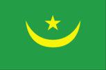
Flag
green with a yellow five-pointed star above a yellow, horizontal crescent; the closed side of the crescent is down; the crescent, star, and color green are traditional symbols of Islam
Independence
28 November 1960 (from France)
Judicial branch
Supreme Court (Cour Supreme)
Land boundaries
- 5,074 km total; Algeria 463 km, Mali 2,237 km, Senegal 813 km, Western Sahara 1,561 km
- none
Land use
- 1% arable land; NEGL% permanent crops; 38% meadows and pastures; 5% forest and woodland; 56% other; includes NEGL% irrigated
- 54% arable land; 4% permanent crops; 4% meadows and pastures; 31% forest and woodland; 7% other; includes 9% irrigated
Leaders
Chief of State and Head of Government— President Col. Maaouiya Ould Sid'Ahmed TAYA (since 12 December 1984) Political parties and leaders: suspended
Legal system
based on Islamic law
Legislative branch
unicameral National Assembly (Assemblee Nationale), dissolved after 10 July 1978 coup; legislative power resides with the CMSN
Member of
ACP, AfDB, AIOEC, Arab League, CCC, CEAO, C1PEC (associate), EAMA, EIB (associate), FAO, G-77, GATT, IBRD, ICAO, IDA, IDB— Islamic Development Bank, IFAD, IFC, ILO, IMF, IMO, INTELSAT, INTERPOL, 1PU, ITU, NAM, OAU, QIC, OMVS (Organization for the Development of the Senegal River Valley), UN, UNESCO, UPU, WHO, WIPO, WMO
National holiday
Independence Day, 28 November (1960)
Natural resources
- iron ore, gypsum, fish, copper, phosphate
- arable land, fish
Note
located 900 km east of Madagascar in the Indian Ocean
Suffrage
none
Terrain
- mostly barren, flat plains of the Sahara; some central hills
- small coastal plain rising to discontinuous mountains encircling central plateau
Territorial sea
- 1 2 nm
- 1 2 nm
Total area
- 1,030,700 km2; land area: 1 ,030,400 km2
- 1,860 km2; land area: 1,850 km2; includes Agalega Islands, Cargados Carajos Shoals (St. Brandon) and Rodrigues
Type
republic; military first seized power in bloodless coup 10 July 1978; a palace coup that took place on 24 December 1984 brought President Taya to power
People and Society
Birth rate
- 49 births/ 1 ,000 population (1990)
- 21 births/ 1,000 population (1990)
Death rate
- 1 8 deaths/ 1 ,000 population (1990)
- 6 deaths/ 1, 000 population (1990)
Ethnic divisions
- 40% mixed Maur/black, 30% Maur, 30% black
- 68% I ndoMauritian, 27% Creole, 3% SinoMauritian, 2% Franco-Mauritian
Infant mortality rate
- 96 deaths/ 1,000 live births (1990)
- 20 deaths/ 1,000 live births (1990)
Labor force
- 465,000 (1981 est.); 45,000 wage earners (1980); 47% agriculture, 29% services, 14% industry and commerce, 10% government; 53% of population of working age (1985)
- 335,000; 29% government services, 27% agriculture and fishing, 22% manufacturing, 22% other; 43% of population of working age (1985)
Language
- Hasaniya Arabic (national); French (official); Toucouleur, Fula, Sarakole, Wolof
- English (official), Creole, French, Hindi, Urdu, Hakka, Bojpoori
Life expectancy at birth
- 44 years male, 49 years female (1990)
- 66 years male, 73 years female (1990)
Literacy
- 17%
- 82.8%
Nationality
- noun — Mauritanian(s); adjective— Mauritanian
- noun — Mauritian(s); adjective— Mauritian
Net migration rate
- 0 migrants/ 1,000 population (1990)
- 4 migrants/ 1,000 population (1990)
Organized labor
- 30,000 members claimed by single union, Mauritanian Workers' Union
- 35% of labor force in more than 270 unions
Population
- 1,934,549 (July 1990), growth rate 3.1% (1990)
- 1,070,005 (July 1990), growth rate 1.8% (1990)
Religion
- nearly 100% Muslim
- 51% Hindu, 30% Christian (mostly Roman Catholic with a few Anglicans), 17% Muslim, 2% other
Total fertility rate
- 7.3 children born/ woman (1990)
- 2.0 children born/ woman (1990)
Government
Administrative divisions
5 urban councils and 3 district councils*; Beau Bassin-Rose Hill, Curepipe, Moka-Flacq*, North*, Port Louis, Quatre Bornes, South*, Vacoas-Phoenix; note — there may now be 4 urban councils and 9 district councils* named Beau Bassin-Rose Hill, Black River*, Curepipe, Flacq*, Grand Port*, Moka*, Pamplemousses*, Plaine Wilhems*, Port Louis*, Quartre Bornes, Riviere du Rempart*, Savanne*, and Vacoas-Phoenix
Capital
Port Louis
Communists
may be 2,000 sympathizers; several Communist organizations; Mauritius Lenin Youth Organization, Mauritius Women's Committee, Mauritius Communist Party, Mauritius People's Progressive Party, Mauritius Young Communist League, Mauritius Liberation Front, Chinese Middle School Friendly Association, Mauritius/USSR Friendship Society
Constitution
12 March 1968
Diplomatic representation
Ambassador Chitmansing JESSERAMSING; Chancery at Suite 134, 4301 Connecticut Avenue NW, Washington DC 20008; telephone (202) 244-1491 or 1492; US— Ambassador Penne KORTH; Embassy at 4th Floor, Rogers Building, John Kennedy Street, Port Louis; telephone 082347
Elections
Legislative Assembly — last held on 30 August 1987 (next to be held 30 August 1 992); results — percent of vote by party NA; seats — (70 total, 62 elected) MSM 24, MMM 21, MLP 10, PMSD 5, others 10
Executive branch
British monarch, governor general, prime minister, deputy prime minister, Council of Ministers (cabinet)
Flag
four equal horizontal bands of red (top), blue, yellow, and green
Independence
12 March 1968 (from UK)
Judicial branch
Supreme Court
Leaders
Chief of State — Queen ELIZABETH II (since 6 February 1952), represented by Governor General Sir Veerasamy RINGADOO (since 17 January 1986); Head of Government — Prime Minister Anerood JUGNAUTH (since 12 June 1982); Deputy Prime Minister Sir Satcam BOOLELL (since 15 August 1988) Political parties and leaders: the government is currently controlled by a coalition composed of the Militant Socialist Movement (MSM), A. Jugnauth, and the Mauritian Labor Party (MLP), S. Boolell; the main opposition union consists of the Mauritian Militant Movement (MMM), Prem Nababsing; Socialist Workers Front, Sylvio Michel; Democratic Labor Movement, Anil Baichoo; Mauritian Social Democratic Party (PMSD), G. Duval
Legal system
based on French civil law system with elements of English common law in certain areas
Legislative branch
unicameral Legislative Assembly
Long-form name
- Islamic Republic of
- none
Member of
ACP, AfDB, CCC, Commonwealth, FAO, G-77, GATT, IAEA, IBRD, ICAO, IDA, IFAD, IFC, ILO, IMF, IMO, INTELSAT, INTERPOL, ISO, ITU, IWC— International Wheat Council, NAM, OAU, OCAM, UN, UNESCO, UPU, WFTU, WHO, WIPO, WMO, WTO
National holiday
Independence Day, 12 March (1968)
Other political or pressure groups
various labor unions
Suffrage
universal at age 18
Type
parliamentary democracy
Economy
Agriculture
- accounts for 29% of GDP (including fishing); largely subsistence farming and nomadic cattle and sheep herding except in Senegal river valley; crops — dates, millet, sorghum, root crops; fish products number-one export; large food deficit in years of drought
- accounts for 14% of GDP; about 90% of cultivated land in sugarcane; other products — tea, corn, potatoes, bananas, pulses, cattle, goats, fish; net food importer, especially rice and fish
Aid
- US commitments, including Ex-Im (FY70-88), $160 million; Western (nonUS) countries, ODA and OOF bilateral commitments (1970-87), $1.1 billion; OPEC bilateral aid (1979-89), $490 million; Communist countries (1970-88), $277 million
- US commitments, including Ex-Im (FY70-88), $72 million; Western (non-US) countries (1970-87), $538 million; Communist countries (1970-88), $54 million
Budget
- revenues $358 million; expenditures $334 million, including capital expenditures of $79 million (1988 est.)
- revenues $351 million; expenditures $414 million, including capital expenditures of $76 million (FY87 est.)
Currency
- ouguiya (plural — ouguiya); 1 ouguiya (UM) = 5 khoums
- Mauritian rupee (plural — rupees); 1 Mauritian rupee (MauR) = 100 cents
Electricity
- 189,000 kW capacity; 136 million kWh produced, 70 kWh per capita (1989)
- 233,000 kW capacity; 420 million kWh produced, 375 kWh per capita (1989)
Exchange rates
- ouguiya (UM) per US$1— 83.838 (January 1990), 83.051 (1989), 75.261 (1988), 73.878 (1987), 74.375 (1986), 77.085 (1985)
- Mauritian rupees (MauRs) per US$1— 15.033 (January 1990), 15.250(1989), 13.438(1988), 12.878(1987), 13.466(1986), 15.442 (1985)
Exports
- $424 million (f.o.b., 1988); commodities— iron ore, processed fish, small amounts of gum arabic and gypsum, unrecorded but numerically significant cattle exports to Senegal; partners — EC 57%, Japan 39%, Ivory Coast 2%
- $1.0 billion (f.o.b., 1988); commodities— textiles 44%, sugar 40%, light manufactures 1 0%; partners — EC and US have preferential treatment, EC 77%, US 15%
External debt
- $2.3 billion (December 1989)
- $670 million (December 1989)
Fiscal year
- calendar year
- 1 July-30 June
GDP
- $1.0 billion, per capita $520; real growth rate 3.6% (1988)
- $1.9 billion, per capita $1,910; real growth rate 6.3% (1988)
Illicit drugs
illicit producer of cannabis for the international drug trade
Imports
- $365 million (c.i.f., 1988); commodities— foodstuffs, consumer goods, petroleum products, capital goods; partners—EC 79%, Africa 5%, US 4%, Japan 2%
- $1.3 billion (c.i.f., 1988); commodities— manufactured goods 50%, capital equipment 17%, foodstuffs 13%, petroleum products 8%, chemicals 7%; partners — EC, US, South Africa, Japan
Industrial production
- growth rate 4.4% (1988 est.) Mauritania (continued) Mauritius
- growth rate 12.9% (FY87)
Industries
- fishing, fish processing, mining of iron ore and gypsum
- food processing (largely sugar milling), textiles, wearing apparel, chemical and chemical products, metal products, transport equipment, nonelectrical machinery, tourism
Inflation rate (consumer prices)
- 1 .4% (1988 est.)
- 9.2% (1988)
Overview
- A majority of the population still depends on agriculture and livestock for a livelihood, even though most of the nomads and many subsistence farmers were forced into the cities by recurrent drought in 1983. Mauritania has extensive deposits of iron ore that account for almost 50% of total exports. The decline in world demand for this ore, however, has led to cutbacks in production in recent years. The nation's coastal waters are among the richest fishing areas in the world, but overexploitation by foreigners threatens this key source of revenue. The country's first deepwater port opened near Nouakchott in 1986.
- The economy is based on sugar, manufacturing (mainly textiles), and tourism. Despite significant expansion in other sectors over the past decade, sugarcane remains dominant and is grown on about 90% of the cultivated land area, accounting for 40% of export earnings. The government's development strategy is centered on industrialization (with a view to exports), agricultural diversification, and tourism. Economic performance in 1988 was impressive, with 6.3% real growth rate and low unemployment.
Unemployment rate
- 50% (1988 est.)
- 3.6% (1988)
Communications
Airports
- 30 total, 29 usable; 9 with permanent-surface runways; none with runways over 3,659 m; 4 with runways 2,440-3,659 m; 17 with runways 1,2202,439 m
- 5 total, 4 usable; 2 with permanent-surface runways; none with runways over 3,659 m; 1 with runways 2,440-3,659 m
Branches
- Army, Navy, Air Force, paramilitary Gendarmerie, paramilitary National Guard, paramilitary National Police, paramilitary Presidential Guard, paramilitary Nomad Security Guards
- paramilitary Special Mobile Force, Special Support Units, regular Police Force
Civil air
- 2 major transport aircraft
- 4 major transport aircraft
Defense expenditures
- 4.2% of GDP (1987) Agalega Islands. Cargados Carajos Shoals, and Rodngues are not shown Indian Ocean ,• Ooodlandl Set reflonil map VII
- NA
Highways
- 7,525 km total; 1,685 km paved; 1,040 km gravel, crushed stone, or otherwise improved; 4,800 km unimproved roads, trails, tracks
- 1,800 km total; 1,640 km paved, 160 km earth
Inland waterways
mostly ferry traffic on the Senegal River
Merchant marine
- 1 cargo ship (1,000 GRT or over) totaling 1,272 CRT/ 1,840 DWT
- 9 ships (1,000 GRT or over) totaling 143,029 CRT/ 248,754 DWT; includes 1 passenger-cargo, 3 cargo, 1 petroleum, oils, and lubricants (POL) tanker, 1 liquefied gas, 3 bulk
Military manpower
- males 15-49, 410,153; 200,212 fit for military service; conscription law not implemented
- males 15-49, 297,975; 153,130 fit for military service
Ports
- Nouadhibou, Nouakchott
- Port Louis
Railroads
670 km 1.435-meter standard gauge, single track, owned and operated by government mining company
Telecommunications
- poor system of cable and open-wire lines, minor radio relay links, and radio communications stations; 5,200 telephones; stations — 2 AM, no FM, I TV; satellite earth stations — 1 Atlantic Ocean INTELSAT and 2 ARABSAT, with a third planned Defense Forces
- small system with good service; new microwave link to Reunion; high-frequency radio links to several countries; 48,000 telephones; stations — 2 AM, no FM, 4 TV; 1 Indian Ocean INTELSAT earth station Defense Forces