1996 Edition
CIA World Factbook 1996 (Project Gutenberg)
Introduction
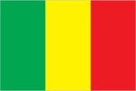
Description
three equal vertical bands of green (hoist side), yellow, and red; uses the popular pan-African colors of Ethiopia
Location
17 00 N, 4 00 W -- Western Africa, southwest of Algeria Flag ----
Geography
Area
- comparative area
- slightly less than twice the size of Texas
- land area
- 1.22 million sq km
- total area
- 1.24 million sq km
Climate
subtropical to arid; hot and dry February to June; rainy, humid, and mild June to November; cool and dry November to February
Coastline
0 km (landlocked)
Environment
- current issues
- deforestation; soil erosion; desertification; inadequate supplies of potable water; poaching
- international agreements
- party to - Biodiversity, Climate Change, Desertification, Endangered Species, Law of the Sea, Ozone Layer Protection, Wetlands; signed, but not ratified - Nuclear Test Ban
- natural hazards
- hot, dust-laden harmattan haze common during dry seasons; recurring droughts
Geographic coordinates
17 00 N, 4 00 W
Geographic note
landlocked
International disputes
the disputed international boundary between Burkina Faso and Mali was submitted to the International Court of Justice (ICJ) in October 1983 and the ICJ issued its final ruling in December 1986, which both sides agreed to accept; Burkina Faso and Mali are proceeding with boundary demarcation, including the tripoint with Niger
Irrigated land
50 sq km (1989 est.)
Land boundaries
- border countries
- Algeria 1,376 km, Burkina Faso 1,000 km, Guinea 858 km, Cote d'Ivoire 532 km, Mauritania 2,237 km, Niger 821 km, Senegal 419 km
- total
- 7,243 km
Land use
- arable land
- 2%
- forest and woodland
- 7%
- meadows and pastures
- 25%
- other
- 66%
- permanent crops
- 0%
Location
Western Africa, southwest of Algeria
Map references
Africa
Maritime claims
none (landlocked)
Natural resources
gold, phosphates, kaolin, salt, limestone, uranium, bauxite, iron ore, manganese, tin, and copper deposits are known but not exploited
Terrain
- mostly flat to rolling northern plains covered by sand; savanna in south, rugged hills in northeast
- highest point
- Hombori Tondo 1,155 m
- lowest point
- Senegal River 23 m
People and Society
Age structure
0-14 years: 48% (male 2,310,294; female 2,308,941) 15-64 years: 49% (male 2,231,244; female 2,488,276) 65 years and over: 3% (male 149,370; female 165,136) (July 1996 est.)
Birth rate
51.38 births/1,000 population (1996 est.)
Death rate
19.49 deaths/1,000 population (1996 est.)
Ethnic divisions
Mande 50% (Bambara, Malinke, Sarakole), Peul 17%, Voltaic 12%, Songhai 6%, Tuareg and Moor 10%, other 5%
Infant mortality rate
102.7 deaths/1,000 live births (1996 est.)
Languages
French (official), Bambara 80%, numerous African languages
Life expectancy at birth
- female
- 48.6 years (1996 est.)
- male
- 45.12 years
- total population
- 46.84 years
Literacy
- age 15 and over can read and write (1995 est.)
- female
- 23.1%
- male
- 39.4%
- total population
- 31%
Nationality
- adjective
- Malian
- noun
- Malian(s)
Net migration rate
-2.37 migrant(s)/1,000 population (1996 est.)
Population
9,653,261 (July 1996 est.)
Population growth rate
2.95% (1996 est.)
Religions
Muslim 90%, indigenous beliefs 9%, Christian 1%
Sex ratio
- all ages
- 0.94 male(s)/female (1996 est.)
- at birth
- 1.03 male(s)/female
- under 15 years
- 1 male(s)/female 15-64 years: 0.9 male(s)/female 65 years and over: 0.9 male(s)/female
Total fertility rate
7.25 children born/woman (1996 est.)
Government
Administrative divisions
8 regions (regions, singular - region); Gao, Kayes, Kidal, Koulikoro, Mopti, Segou, Sikasso, Tombouctou
Capital
Bamako
Constitution
adopted 12 January 1992
Data code
ML
Diplomatic representation in US
- chancery
- 2130 R Street NW, Washington, DC 20008
- chief of mission
- Ambassador Cheick Oumar DIARRAH
- telephone
- [1] (202) 332-2249, 939-8950
Executive branch
- cabinet
- Council of Ministers was appointed by the prime minister
- chief of state
- President Alpha Oumar KONARE (since 8 June 1992) was elected for a five-year term by universal suffrage; election last held NA April 1992 (next to be held NA April 1997); Alpha KONARE was elected in runoff race against Montaga TALL
- head of government
- Prime Minister Ibrahima Boubacar KEITA (since NA March 1994) was appointed by the president
FAX
[223] 22 37 12
Flag
three equal vertical bands of green (hoist side), yellow, and red; uses the popular pan-African colors of Ethiopia
Independence
22 September 1960 (from France)
International organization participation
ACCT, ACP, AfDB, CCC, ECA, ECOWAS, FAO, FZ, G-77, IAEA, IBRD, ICAO, ICFTU, ICRM, IDA, IDB, IFAD, IFC, IFRCS, ILO, IMF, Intelsat, Interpol, IOC, ITU, NAM, OAU, OIC, UN, UNAMIR, UNAVEM III, UNCTAD, UNESCO, UNIDO, UNMIH, UPU, WADB, WCL, WFTU, WHO, WIPO, WMO, WToO, WTrO
Judicial branch
Supreme Court (Cour Supreme)
Legal system
based on French civil law system and customary law; judicial review of legislative acts in Constitutional Court (which was formally established on 9 March 1994); has not accepted compulsory ICJ jurisdiction
Legislative branch
unicameral
Name of country
- conventional long form
- Republic of Mali
- conventional short form
- Mali
- former
- French Sudan
- local long form
- Republique de Mali
- local short form
- Mali
National Assembly
elections last held 8 March 1992 (next to be held NA February 1997); results - percent of vote by party NA; seats - (116 total) Adema 76, CNID 9, US/RAD 8, Popular Movement for the Development of the Republic of West Africa 6, RDP 4, UDD 4, RDT 3, UFDP 3, PDP 2, UMDD 1
National holiday
Anniversary of the Proclamation of the Republic, 22 September (1960)
Other political or pressure groups
United Movement and Fronts of Azawad (MFUA); Patriotic Movement of the Ghanda Kaye (MPGK)
Political parties and leaders
Alliance for Democracy (Adema), Ibrahim Baubacar KEITA; National Congress for Democratic Initiative (CNID), Mountaga TALL; Sudanese Union/African Democratic Rally (US/RDA), Mamadou Madeira KEITA; Popular Movement for the Development of the Republic of West Africa; Rally for Democracy and Progress (RDP), Almamy SYLLA; Union for Democracy and Development (UDD), Moussa Balla COULIBALY; Rally for Democracy and Labor (RDT); Union of Democratic Forces for Progress (UFDP), Dembo DIALLO; Party for Democracy and Progress (PDP), Idrissa TRAORE; Malian Union for Democracy and Development (UMDD); Movement for the Independence, the Renaissance and Integration of Africa (MIRIA), Mohammed Lamine TRAORE
Suffrage
21 years of age; universal
Type of government
republic
US diplomatic representation
- chief of mission
- Ambassador David RAWSON
- embassy
- Rue Rochester NY and Rue Mohamed V, Bamako
- mailing address
- B. P. 34, Bamako
- telephone
- [223] 22 54 70
Economy
Agriculture
cotton, millet, rice, corn, vegetables, peanuts; cattle, sheep, goats
Budget
- expenditures
- $697 million, including capital expenditures of $NA (1992 est.)
- revenues
- $376 million
Currency
1 Communaute Financiere Africaine franc (CFAF) = 100 centimes
Economic aid
- recipient
- ODA, $NA
Economic overview
Mali is among the poorest countries in the world, with 65% of its land area desert or semidesert. Economic activity is largely confined to the riverine area irrigated by the Niger. About 10% of the population is nomadic and some 80% of the labor force is engaged in agriculture and fishing. Industrial activity is concentrated on processing farm commodities. The economy is beginning to turn around after contracting through 1992-93, largely because of enhanced exports and import substitute production in the wake of the 50% devaluation of 12 January 1994. Post-devaluation inflation peaked at 35% in 1994, and the government appears to be keeping on track with its IMF structural adjustment program.
Electricity
- capacity
- 90,000 kW
- consumption per capita
- 33 kWh (1993)
- production
- 310 million kWh
Exchange rates
- CFA francs (CFAF) per US$1 - 500.56 (January 1996), 499.15 (1995), 555.20 (1994), 283.16 (1993), 264.69 (1992), 282.11 (1991)
- note
- beginning 12 January 1994, the CFA franc was devalued to CFAF 100 per French franc from CFAF 50 at which it had been fixed since 1948
Exports
- $415 million (f.o.b., 1993)
- commodities
- cotton, livestock, gold
- partners
- mostly franc zone and Western Europe
External debt
$2.8 billion (1995 est.)
Fiscal year
calendar year
GDP
purchasing power parity - $5.4 billion (1994 est.)
GDP composition by sector
- agriculture
- 42.4%
- industry
- 15.4%
- services
- 42.2%
GDP per capita
$600 (1994 est.)
GDP real growth rate
2.4% (1994 est.)
Imports
- $842 million (f.o.b., 1993)
- commodities
- machinery and equipment, foodstuffs, construction materials, petroleum, textiles
- partners
- mostly franc zone and Western Europe
Industrial production growth rate
NA%
Industries
minor local consumer goods production and food processing; construction; phosphate and gold mining
Inflation rate (consumer prices)
8% (1995 est.)
Labor force
- 2.666 million (1986 est.)
- by occupation
- agriculture 80%, services 19%, industry and commerce 1% (1981)
Unemployment rate
NA%
Communications
Branches
Army, Air Force, Gendarmerie, Republican Guard, National Guard, National Police (Surete Nationale)
Defense expenditures
exchange rate conversion - $66 million, 2.2% of GDP (1994)
Manpower availability
- males age 15-49
- 1,925,205
- males fit for military service
- 1,100,599 (1996 est.)
Radio broadcast stations
AM 2, FM 2, shortwave 0
Radios
430,000 (1992 est.)
Telephone system
- domestic system poor but improving; provides only minimal service
- domestic
- network consists of microwave radio relay, open wire, and radiotelephone communications stations; expansion of microwave radio relay in progress
- international
- satellite earth stations - 2 Intelsat (1 Atlantic Ocean and 1 Indian Ocean)
Telephones
11,000 (1982 est.)
Television broadcast stations
2 (1987 est.)
Televisions
11,000 (1992 est.) Defense
Transportation
Airports
- total
- 24
- with paved runways 2 438 to 3 047 m
- 4
- with paved runways 914 to 1 523 m
- 2
- with paved runways under 914 m
- 7
- with unpaved runways 1 524 to 2 437 m
- 3
- with unpaved runways 914 to 1 523 m
- 8 (1995 est.)
Highways
- paved
- 1,661 km
- total
- 15,610 km
- unpaved
- 13,949 km (1987 est.)
Ports
Koulikoro
Railways
- narrow gauge
- 641 km 1.000-m gauge (1995)
- total
- 641 km; note - linked to Senegal's rail system through Kayes
Waterways
1,815 km navigable