1994 Edition
CIA World Factbook 1994 (Project Gutenberg)
Introduction
Administrative divisions
- 8 regions (regions, singular - region); Gao, Kayes, Kidal, Koulikoro, Mopti, Segou, Sikasso, Tombouctou
- 18 regions (plural - NA, singular - gobolka); Awdal, Bakool, Banaadir, Bari, Bay, Galguduud, Gedo, Hiiraan, Jubbada Dhexe, Jubbada Hoose, Mudug, Nugaal, Sanaag, Shabeellaha Dhexe, Shabeellaha Hoose, Sool, Togdheer, Woqooyi Galbeed
Agriculture
- accounts for 50% of GDP; most production based on small subsistence farms; cotton and livestock products account for over 70% of exports; other crops - millet, rice, corn, vegetables, peanuts; livestock - cattle, sheep, goats
- dominant sector, led by livestock raising (cattle, sheep, goats); crops - bananas, sorghum, corn, mangoes, sugarcane; not self-sufficient in food; distribution of food disrupted by civil strife; fishing potential largely unexploited
Airports
- total: 33 usable: 27 with permanent-surface runways: 8 with runways over 3,659 m: with runways 2,440-3,659 m: 5 with runways 1,220-2,439 m: 11
- total: 76 usable: 59 with permanent-surface runways: 8 with runways over 3,659 m: 2 with runways 2,440-3,659 m: 6 with runways 1,220-2,439 m: 24
Area
- total area: 1.24 million sq km land area: 1.22 million sq km comparative area: slightly less than twice the size of Texas
- total area: 637,660 sq km land area: 627,340 sq km comparative area: slightly smaller than Texas
Birth rate
- 51.79 births/1,000 population (1994 est.)
- 45.97 births/1,000 population (1994 est.)
Branches
- Army, Air Force, Gendarmerie, Republican Guard, National Police (Surete Nationale)
- NA
Budget
- revenues: $376 million expenditures: $697 million, including capital expenditures of $NA (1992 est.)
- revenues: $NA expenditures: $NA, including capital expenditures of $NA
Capital
- Bamako
- Mogadishu
Climate
- subtropical to arid; hot and dry February to June; rainy, humid, and mild June to November; cool and dry November to February
- desert; northeast monsoon (December to February), cooler southwest monsoon (May to October); irregular rainfall; hot, humid periods (tangambili) between monsoons
Coastline
- 0 km (landlocked)
- 3,025 km
Constitution
- new constitution adopted in constitutional referendum in 12 January 1992
- 25 August 1979, presidential approval 23 September 1979
Currency
- 1 CFA franc (CFAF) = 100 centimes
- 1 Somali shilling (So. Sh.) = 100 cents
Death rate
- 20.36 deaths/1,000 population (1994 est.)
- 13.53 deaths/1,000 population (1994 est.)
Defense expenditures
- exchange rate conversion - $41 million, 2% of GDP (1989)
- $NA, NA% of GDP
Digraph
- ML
- SO
Diplomatic representation in US
- chief of mission: Ambassador Siragatou Ibrahim CISSE chancery: 2130 R Street NW, Washington, DC 20008 telephone: (202) 332-2249 or 939-8950
- Somalian Embassy ceased operations on 8 May 1991
Economic aid
- recipient: US commitments, including Ex-Im (FY70-89), $349 million; Western (non-US) countries, ODA and OOF bilateral commitments (1970-89), $3.02 billion; OPEC bilateral aid (1979-89), $92 million; Communist countries (1970-89), $190 million
- recipient: US commitments, including Ex-Im (FY70-89), $639 million; Western (non-US) countries, ODA and OOF bilateral commitments (1970-89), $3.8 billion; OPEC bilateral aid (1979-89), $1.1 billion; Communist countries (1970-89), $336 million
Electricity
- capacity: 260,000 kW production: 750 million kWh consumption per capita: 90 kWh (1991)
- capacity: former 75,000 kW is almost completely shut down by the destruction of the civil war; UN, relief organizations, and foreign military units in Somalia use their own portable power systems production: NA consumption per capita: NA
Environment
- current issues: deforestation; soil erosion; desertification; inadequate supplies of safe drinking water; poaching natural hazards: hot, dust-laden harmattan haze common during dry seasons; recurring droughts international agreements: party to - Law of the Sea, Wetlands; signed, but not ratified - Climate Change, Nuclear Test Ban
- current issues: use of contaminated water contributes to health problems; deforestation; overgrazing; soil erosion; desertification natural hazards: recurring droughts; frequent dust storms over eastern plains in summer international agreements: party to - Endangered Species, Law of the Sea; signed, but not ratified - Marine Dumping, Nuclear Test Ban
Ethnic divisions
- Mande 50% (Bambara, Malinke, Sarakole), Peul 17%, Voltaic 12%, Songhai 6%, Tuareg and Moor 10%, other 5%
- Somali 85%, Bantu, Arabs 30,000, Europeans 3,000, Asians 800
Exchange rates
- Communaute Financiere Africaine francs (CFAF) per US$1 - 592.05 (January 1994), 283.16 (1993), 264.69 (1992), 282.11 (1991), 272.26 (1990), 319.01 (1989) note: beginning 12 January 1994, the CFA franc was devalued to CFAF 100 per French franc from CFAF 50 at which it had been fixed since 1948
- Somali shillings (So. Sh.) per US$1 - 2,616 (1 July 1993), 4,200 (December 1992), 3,800.00 (December 1990), 490.7 (1989)
Executive branch
- chief of state: President Alpha Oumar KONARE (since 8 June 1992); election last held in April 1992 (next to be held NA 1997); Alpha KONARE was elected in runoff race against Montaga TALL head of government: Prime Minister Ibrahima Boubacar KEITA (since March 1994) cabinet: Council of Ministers; appointed by the prime minister
- Somalia has no functioning government; presidential elections last held 23 December 1986 (next to be held NA); results - President SIAD was reelected without opposition
Exports
- $330 million (f.o.b., 1992 est.) commodities: cotton, livestock, gold partners: mostly franc zone and Western Europe
- $58 million (1990 est.) commodities: bananas, live animals, fish, hides partners: Saudi Arabia, Italy, FRG (1986)
External debt
- $2.6 billion (1991 est.)
- $1.9 billion (1989)
FAX
[223] 228059
Fiscal year
- calendar year
- calendar year
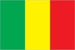
Flag
- three equal vertical bands of green (hoist side), yellow, and red; uses the popular pan-African colors of Ethiopia
- light blue with a large white five-pointed star in the center; design based on the flag of the UN (Italian Somaliland was a UN trust territory)
Highways
- total: 15,700 km paved: 1,670 km unpaved: gravel, improved earth 3,670 km; unimproved earth 10,360 km
- total: 22,500 km paved: 2,700 km unpaved: gravel 3,000 km; improved, stabilized earth 16,800 km (1992)
Imports
- $682 million (f.o.b., 1992 est.) commodities: machinery and equipment, foodstuffs, construction materials, petroleum, textiles partners: mostly franc zone and Western Europe
- $249 million (1990 est.) commodities: petroleum products, foodstuffs, construction materials partners: US 13%, Italy, FRG, Kenya, UK, Saudi Arabia (1986)
Independence
- 22 September 1960 (from France)
- 1 July 1960 (from a merger of British Somaliland, which became independent from the UK on 26 June 1960, and Italian Somaliland, which became independent from the Italian-administered UN trusteeship on 1 July 1960, to form the Somali Republic)
Industrial production
- growth rate -1.4% (1992 est.); accounts for 13.0% of GDP
- growth rate 0% (1990); accounts for 4% of GDP
Industries
- small local consumer goods and processing, construction, phosphate, gold, fishing
- a few small industries, including sugar refining, textiles, petroleum refining; probably shut down by the widespread destruction during the civil war
Infant mortality rate
- 106.2 deaths/1,000 live births (1994 est.)
- 125.8 deaths/1,000 live births (1994 est.)
Inflation rate (consumer prices)
- 2% (1992 est.)
- 210% (1989)
Inland waterways
1,815 km navigable
International disputes
- the disputed international boundary between Burkina and Mali was submitted to the International Court of Justice (ICJ) in October 1983 and the ICJ issued its final ruling in December 1986, which both sides agreed to accept; Burkina and Mali are proceeding with boundary demarcation, including the tripoint with Niger
- southern half of boundary with Ethiopia is a Provisional Administrative Line; territorial dispute with Ethiopia over the Ogaden
Irrigated land
- 50 sq km (1989 est.)
- 1,600 sq km (1989 est.)
Judicial branch
- Supreme Court (Cour Supreme)
- Supreme Court (non-functioning)
Labor force
- 2.666 million (1986 est.) by occupation: agriculture 80%, services 19%, industry and commerce 1% (1981) note: 50% of population of working age (1985)
- 2.2 million (very few are skilled laborers) by occupation: pastoral nomad 70%, agriculture, government, trading, fishing, handicrafts, and other 30% note: 53% of population of working age (1985)
Land boundaries
- total 7,243 km, Algeria 1,376 km, Burkina 1,000 km, Guinea 858 km, Cote d'Ivoire 532 km, Mauritania 2,237 km, Niger 821 km, Senegal 419 km
- total 2,366 km, Djibouti 58 km, Ethiopia 1,626 km, Kenya 682 km
Land use
- arable land: 2% permanent crops: 0% meadows and pastures: 25% forest and woodland: 7% other: 66%
- arable land: 2% permanent crops: 0% meadows and pastures: 46% forest and woodland: 14% other: 38%
Languages
- French (official), Bambara 80%, numerous African languages
- Somali (official), Arabic, Italian, English
Legal system
- based on French civil law system and customary law; judicial review of legislative acts in Constitutional Court (which was formally established on 9 March 1994); has not accepted compulsory ICJ jurisdiction
- NA
Legislative branch
- unicameral
- unicameral People's Assembly
Life expectancy at birth
- total population: 45.91 years male: 44.29 years female: 47.57 years (1994 est.)
- total population: 54.75 years male: 54.49 years female: 55.01 years (1994 est.)
Literacy
- age 15 and over can read and write (1990) total population: 17% male: 26% female: 9%
- age 15 and over can read and write (1990 est.) total population: 24% male: 36% female: 14%
Location
- Western Africa, between Mauritania and Niger
- Eastern Africa, bordering the northwestern Indian Ocean, south of the Arabian Peninsula
Manpower availability
- males age 15-49 1,803,301; fit for military service 1,027,780
- males age 15-49 1,630,864; fit for military service 915,368
Map references
- Africa, Standard Time Zones of the World
- Africa, Standard Time Zones of the World
Maritime claims
- none; landlocked
- territorial sea: 200 nm
Member of
- ACCT, ACP, AfDB, CCC, CEAO, ECA, ECOWAS, FAO, FZ, G-77, GATT, IAEA, IBRD, ICAO, ICFTU, IDA, IDB, IFAD, IFC, ILO, IMF, INTELSAT, INTERPOL, IOC, ISO (correspondent), ITU, LORCS, NAM, OAU, OIC, UN, UNCTAD, UNESCO, UNIDO, UPU, WADB, WCL, WHO, WIPO, WMO, WTO
- ACP, AfDB, AFESD, AL, AMF, CAEU, ECA, FAO, G-77, IBRD, ICAO, IDA, IDB, IFAD, IFC, IGADD, ILO, IMF, IMO, INTELSAT, INTERPOL, IOC, IOM (observer), ITU, LORCS, NAM, OAU, OIC, UN, UNCTAD, UNESCO, UNHCR, UNIDO, UPU, WHO, WIPO, WMO
Merchant marine
2 ships (1,000 GRT or over) totaling 5,554 GRT/6,892 DWT, cargo 1, refrigerated cargo 1
Names
- conventional long form: Republic of Mali conventional short form: Mali local long form: Republique de Mali local short form: Mali former: French Sudan
- conventional long form: none conventional short form: Somalia former: Somali Republic
National Assembly
elections last held on 8 March 1992 (next to be held NA); results - percent of vote by party NA; seats - (total 116) Adema 76, CNID 9, US/RAD 8, Popular Movement for the Development of the Republic of West Africa 6, RDP 4, UDD 4, RDT 3, UFDP 3, PDP 2, UMDD 1
National holiday
- Anniversary of the Proclamation of the Republic, 22 September (1960)
- NA
National product
- GDP - purchasing power equivalent - 5.8 billion (1993 est.)
- GDP - purchasing power equivalent - $3.4 billion (1993 est.)
National product per capita
- $650 (1993 est.)
- $500 (1993 est.)
National product real growth rate
- -6.1% (1992 est.)
- NA%
Nationality
- noun: Malian(s) adjective: Malian
- noun: Somali(s) adjective: Somali
Natural resources
- gold, phosphates, kaolin, salt, limestone, uranium, bauxite, iron ore, manganese, tin, and copper deposits are known but not exploited
- uranium and largely unexploited reserves of iron ore, tin, gypsum, bauxite, copper, salt
Net migration rate
- -3.66 migrant(s)/1,000 population (1994 est.)
- 0 migrant(s)/1,000 population (1994 est.)
Note
- landlocked
- strategic location on Horn of Africa along southern approaches to Bab el Mandeb and route through Red Sea and Suez Canal
Other political or pressure groups
numerous clan and subclan factions are currently vying for power
Overview
- Mali is among the poorest countries in the world, with about 70% of its land area desert or semidesert. Economic activity is largely confined to the riverine area irrigated by the Niger. About 10% of the population live as nomads and some 80% of the labor force is engaged in agriculture and fishing. Industrial activity is concentrated on processing farm commodities. In consultation with international lending agencies, the government has adopted a structural adjustment program for 1992-95, aiming at GDP annual growth of 4.6%, inflation of no more than 2.5% on average, and a substantial reduction in the external current account deficit.
- One of the world's poorest and least developed countries, Somalia has few resources. Moreover, much of the economy has been devastated by the civil war. Agriculture is the most important sector, with livestock accounting for about 40% of GDP and about 65% of export earnings. Nomads and seminomads who are dependent upon livestock for their livelihoods make up more than half of the population. Crop production generates only 10% of GDP and employs about 20% of the work force. The main export crop is bananas; sugar, sorghum, and corn are grown for the domestic market. The small industrial sector is based on the processing of agricultural products and accounts for less than 10% of GDP. Greatly increased political turmoil in 1991-93 has resulted in a substantial drop in output, with widespread famine.
People's Assembly (Golaha Shacbiga)
elections last held 31 December 1984 (next to be held NA); results - SRSP was the only party; seats - (177 total, 171 elected) SRSP 171; note - the United Somali Congress (USC) ousted the regime of Maj. Gen. Mohamed SIAD Barre on 27 January 1991; the provisional government has promised that a democratically elected government will be established
Pipelines
crude oil 15 km
Political parties and leaders
- Association for Democracy (Adema), Alpha Oumar KONARE; National Congress for Democratic Initiative (CNID), Mountaga TALL; Sudanese Union/African Democratic Rally (US/RDA), Mamadou Madeira KEITA; Popular Movement for the Development of the Republic of West Africa; Rally for Democracy and Progress (RDP), Almamy SYLLA; Union for Democracy and Development (UDD), Moussa Balla COULIBALY; Rally for Democracy and Labor (RDT); Union of Democratic Forces for Progress (UFDP), Dembo DIALLO; Party for Democracy and Progress (PDP), Idrissa TRAORE; Malian Union for Democracy and Development (UMDD)
- the United Somali Congress (USC) ousted the former regime on 27 January 1991; formerly the only party was the Somali Revolutionary Socialist Party (SRSP), headed by former President and Commander in Chief of the Army Maj. Gen. Mohamed SIAD Barre
Population
- 9,112,950 (July 1994 est.)
- 6,666,873 (July 1994 est.)
Population growth rate
- 2.78% (1994 est.)
- 3.24% (1994 est.)
Ports
Mogadishu, Berbera, Chisimayu (Kismaayo), Bender Cassim (Boosaaso)
Railroads
642 km 1.000-meter gauge; linked to Senegal's rail system through Kayes
Religions
- Muslim 90%, indigenous beliefs 9%, Christian 1%
- Sunni Muslim
Suffrage
- 21 years of age; universal
- 18 years of age; universal
Telecommunications
- domestic system poor but improving; provides only minimal service with radio relay, wire, and radio communications stations; expansion of radio relay in progress; 11,000 telephones; broadcast stations - 2 AM, 2 FM, 2 TV; satellite earth stations - 1 Atlantic Ocean INTELSAT and 1 Indian Ocean INTELSAT
- the public telecommunications system was completely destroyed or dismantled by the civil war factions; all relief organizations depend on their own private systems (1993)
Terrain
- mostly flat to rolling northern plains covered by sand; savanna in south, rugged hills in northeast
- mostly flat to undulating plateau rising to hills in north
Total fertility rate
- 7.33 children born/woman (1994 est.)
- 7.25 children born/woman (1994 est.)
Type
- republic
- none
Unemployment rate
- NA%
- NA%
US diplomatic representation
- chief of mission: Ambassador William H. DAMERON III embassy: Rue Rochester NY and Rue Mohamed V., Bamako mailing address: B. P. 34, Bamako telephone: [223] 225470
- the US Embassy in Mogadishu was evacuated and closed indefinitely in January 1991; United States Liaison Office (USLO) opened in December 1992