1989 Edition
CIA World Factbook 1989 (Internet Archive)
Geography
Climate
tropical; rainy season (November to May); dry season (May to November)
Coastline
none — landlocked
Comparative area
slightly larger than Pennsylvania
Disputes
dispute with Tanzania over the boundary in Lake Nyasa (Lake Malawi)
Environment
deforestation
Land boundaries
2,881 km total; Mozambique 1,569 km, Tanzania 475 km, Zam-- bia 837 km
Land use
25% arable land; NEGL% permanent crops; 20% meadows and pastures; 50% forest and woodland; 5% other; includes NEGL% irrigated
Maritime claims
none — landlocked
Natural resources
limestone; unexploited deposits of uranium, coal, and bauxite
Note
landlocked
Terrain
narrow elongated plateau with rolling plains, rounded hills, some mountains
Total area
1 18,480 km2; land area: 94,080 km2
Total area
2(X)km Chisamula Island Likoma Island
People and Society
Birth rate
52 births/ 1,000 population (1990)
Death rate
18 deaths/ 1,000 population (1990)
Ethnic divisions
Chewa, Nyanja, Tumbuko, Yao, Lomwe, Sena, Tonga, Ngoni, Ngonde, Asian, European
Infant mortality rate
1 30 deaths/ 1 ,000 live births (1990)
Labor force
428,000 wage earners; 43% agriculture, 16% manufacturing, 15% personal services, 9% commerce, 7% construction, 4% miscellaneous services, 6% other permanently employed (1986)
Language
English and Chichewa (official); other languages important regionally
Life expectancy at birth
48 years male, 50 years female (1990)
Literacy
41.2%
Nationality
noun — Malawian(s); adjective— Malawian
Net migration rate
— 16 migrants/ 1,000 population (1990)
Note
there are 800,000 Mozambican refugees in Malawi (1989 est.)
Organized labor
small minority of wage earners are unionized
Population
9,157,528 (July 1990), growth rate 1.8% (1990)
Religion
55% Protestant, 20% Roman Catholic, 20% Muslim; traditional indigenous beliefs are also practiced
Total fertility rate
7.7 children born/ woman (1990)
Government
Administrative divisions
24 districts; Blantyre, Chikwawa, Chiradzulu, Chitipa, Dedza, Dowa, Karonga, Kasungu, Kasupe, Lilongwe, Mangochi, Mchinji, Mulanje, Mwanza, Mzimba, Ncheu, Nkhata Bay, Nkhota Kota, Nsanje, Ntchisi, Rumphi, Salima, Thyolo, Zomba
Capital
Lilongwe
Communists
no Communist party
Constitution
6 July 1964; republished as amended January 1974
Diplomatic representation
Ambassador Robert B. MBAYA; Chancery at 2408 Massachusetts Avenue NW, Washington DC 20008; telephone (202) 797-1007; US— Ambassador George A. TRAIL, III; Embassy in new capital city development area, address NA (mailing address is P. O. Box 30016, Lilongwe); telephone 730-
Elections
President — President Banda sworn in as President for Life on 6 July 1971; National Assembly — last held 27-28 May 1987 (next to be held by May 1992); results— MCP is the only party; seats — (133 total, 1 12 elected) MCP 133
Executive branch
president. Cabinet
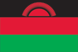
Flag
three equal horizontal bands of black (top), red, and green with a radiant, rising, red sun centered in the black band; similar to the flag of Afghanistan which is longer and has the national coat of arms superimposed on the hoist side of the black and red bands
Independence
6 July 1964 (from UK; formerly Nyasaland)
Judicial branch
High Court, Supreme Court of Appeal
Leaders
Chief of State and Head of Government— President Dr. Hastings Kamuzu BANDA (since 6 July 1966; sworn in as President for Life 6 July 1971) Political parties and leaders: only party — Malawi Congress Party (MCP), Maxwell Pashane, administrative secretary; John Tembo, treasurer general; top party position of secretary general vacant since
Legal system
based on English common law and customary law; judicial review of legislative acts in the Supreme Court of Appeal; has not accepted compulsory ICJ jurisdiction
Legislative branch
unicameral National Assembly
Long-form name
Republic of Malawi
Member of
ACP, AfDB, CCC, Commonwealth, EC (associated member), FAO, G-77, GATT, IBRD, ICAO, IDA, IFAD, IFC, ILO, IMF, INTELSAT, INTERPOL, IPU, ISO, ITU, NAM, OAU, SADCC, UN, UNESCO, UPU, WHO, WIPO, WMO, WTO
National holiday
Independence Day, 6 July (1964)
Suffrage
universal at age 21
Type
one-party state
Economy
Agriculture
accounts for 40% of GDP; cash crops — tobacco, sugarcane, cotton, tea, and corn; subsistence crops — potatoes, cassava, sorghum, pulses; livestock — cattle and goats
Aid
US commitments, including Ex-Im (FY70-88), $182 million; Western (nonUS) countries, ODA and OOF bilateral commitments (1970-87), $1.8 billion
Budget
revenues $246 million; expenditures $390 million, including capital expenditures of $97 million (FY88 est.)
Currency
Malawian kwacha (plural — kwacha); 1 Malawian kwacha (MK) = 100 tambala
Electricity
181,000 kW capacity; 535 million kWh produced, 60 kWh per capita (1989) Malaysia
Exchange rates
Malawian kwacha (MK) per US$1— 2.6793 (January 1990), 2.7595 (1989), 2.5613 (1988), 2.2087 (1987), 1.8611 (1986), 1.7191 (1985)
Exports
$292 million (f.o.b., 1988); commodities— tobacco, tea, sugar, coffee, peanuts; partners — US, UK, Zambia, South Africa, FRG
External debt
$1.4 billion (December 1989 est.)
Fiscal year
1 April-3 1 March
GDP
$1.4 billion, per capita $180; growth rate 3.6% (1988)
Imports
$402 million (c.i.f., 1988); commodities— food, petroleum, semimanufactures, consumer goods, transportation equipment; partners — South Africa, Japan, US, UK, Zimbabwe
Industrial production
growth rate 6.4% (1988)
Industries
agricultural processing (tea, tobacco, sugar), sawmilling, cement, consumer goods
Inflation rate (consumer prices)
31.5% (1988)
Overview
A landlocked country, Malawi ranks among the world's least developed with a per capita GDP of $180. The economy is predominately agricultural and operates under a relatively free enterprise environment, with about 90% of the population living in rural areas. Agriculture accounts for 40% of GDP and 90% of export revenues. After two years of weak performance, economic growth improved significantly in 1988 as a result of good weather and a broadly based economic adjustment effort by the government. The closure of traditional trade routes through Mozambique continues to be a constraint on the economy.
Unemployment rate
NA%
Communications
Airports
48 total, 47 usable; 6 with permanent-surface runways; none with runways over 3,659 m; 1 with runways 2,440-3,659 m; 9 with runways 1 ,220-2,439 m
Branches
Army, Army Air Wing, Army Naval Detachment, paramilitary Police Mobile Force Unit, paramilitary Young Pioneers Military manpower males 15-49, 1,904,445; 967,032 fit for military service
Civil air
3 major transport aircraft
Defense expenditures
1 .6% of GDP, or $22 million (1989 est.) 500km TO««9«To South
Highways
13,135 km total; 2,364 km paved; 251 km crushed stone, gravel, or stabilized soil; 10,520 km earth and improved earth
Inland waterways
Lake Nyasa (Lake Malawi); Shire River, 144 km
Note
a majority of exports would normally go through Mozambique on the Beira or Nacala railroads, but now most go through South Africa because of insurgent activity and damage to rail lines Defense Forces
Ports
Chipoka, Monkey Bay, Nkhata Bay, and Nkotakota — all on Lake Nyasa (Lake Malawi)
Railroads
789 km 1 .067-meter gauge
Telecommunications
fair system of openwire lines, radio relay links, and radio communication stations; 36,800 telephones; stations — 8 AM, 4 FM, no TV; satellite earth stations — 1 Indian Ocean INTELSAT and 1 Atlantic Ocean INTELSAT