2024 Edition
CIA World Factbook 2024 (factbook.json @ b8538d78e87c)
Introduction
Background
Berbers have inhabited central north Africa since ancient times, but Phoenicians, Greeks, Carthaginians, Persians, Egyptians, Romans, and Vandals have all settled and ruled the region. In the 7th century, Islam spread through the area. In the mid-16th century, Ottoman rule began; the Italians supplanted the Ottoman Turks in the area around Tripoli in 1911 and held it until 1943, when they were defeated in World War II. Libya then came under UN administration and achieved independence in 1951. Col. Muammar al-QADHAFI assumed leadership with a military coup in 1969 and began to espouse a political system that combined socialism and Islam. During the 1970s, QADHAFI used oil revenues to promote his ideology outside Libya, supporting subversive and terrorist activities that included the downing of two airliners -- one over Scotland and another in Northern Africa -- and a discotheque bombing in Berlin. UN sanctions in 1992 isolated QADHAFI politically and economically; the sanctions were lifted in 2003 when Libya accepted responsibility for the bombings and agreed to claimant compensation. QADHAFI also agreed to end Libya's program to develop weapons of mass destruction, and he made significant strides in normalizing relations with Western nations. Unrest that began in several Middle Eastern and North African countries in 2010 erupted in Libyan cities in 2011. QADHAFI's brutal crackdown on protesters spawned an eight-month civil war that saw the emergence of a National Transitional Council (NTC), UN authorization of air and naval intervention by the international community, and the toppling of the QADHAFI regime. In 2012, the NTC handed power to an elected parliament, the General National Congress (GNC), which was replaced two years later with the House of Representatives (HoR). In 2015, the UN brokered the Libyan Political Agreement (LPA) among a broad array of political parties and social groups, establishing an interim executive body. However, hardliners continued to oppose and hamper the LPA implementation, leaving Libya with eastern and western-based rival governments. In 2018, the international community supported a recalibrated plan that aimed to break the political deadlock with a National Conference in 2019. These plans, however, were derailed when the eastern-based, self-described Libyan National Army (LNA) launched an offensive to seize Tripoli. The LNA offensive collapsed in 2020, and a subsequent UN-sponsored cease-fire helped formalize the pause in fighting between rival camps. In 2021, the UN-facilitated Libyan Political Dialogue Forum selected a new prime minister for an interim government -- the Government of National Unity (GNU) -- and a new presidential council charged with preparing for elections and uniting the country’s state institutions. The HoR approved the GNU and its cabinet the same year, providing Libya with its first unified government since 2014, but the parliament then postponed the planned presidential election to an undetermined date in the future. In 2022, the HoR voted to replace GNU interim Prime Minister, Abdul Hamid DUBAYBAH, with another government led by Fathi BASHAGHA. GNU allegations of an illegitimate HoR vote allowed DUBAYBAH to remain in office and rebuff BASHAGHA's attempts to seat his government in Tripoli. In 2023, the HoR voted to replace BASHAGHA with Osma HAMAD. Special Representative of the UN Security-General for Libya, Abdoulaye BATHILY, is leading international efforts to persuade key Libyan political actors to resolve the core issues impeding elections.
Geography
Area
- land
- 1,759,540 sq km
- total
- 1,759,540 sq km
- water
- 0 sq km
Area - comparative
about 2.5 times the size of Texas; slightly larger than Alaska
Climate
Mediterranean along coast; dry, extreme desert interior
Coastline
1,770 km
Elevation
- highest point
- Bikku Bitti 2,267 m
- lowest point
- Sabkhat Ghuzayyil -47 m
- mean elevation
- 423 m
Geographic coordinates
25 00 N, 17 00 E
Geography - note
note 1: more than 90% of the country is desert or semidesertnote 2: the volcano Waw an Namus lies in south central Libya in the middle of the Sahara; the caldera is an oasis -- the name means "oasis of mosquitoes" -- containing several small lakes surrounded by vegetation and hosting various insects and a large diversity of birds
Irrigated land
4,700 sq km (2012)
Land boundaries
- border countries
- Algeria 989 km; Chad 1,050 km; Egypt 1,115 km; Niger 342 km; Sudan 382 km; Tunisia 461 km
- total
- 4,339 km
Land use
- agricultural land
- 8.8% (2018 est.)
- agricultural land: arable land
- arable land: 1% (2018 est.)
- agricultural land: permanent crops
- permanent crops: 0.2% (2018 est.)
- agricultural land: permanent pasture
- permanent pasture: 7.6% (2018 est.)
- forest
- 0.1% (2018 est.)
- other
- 91.1% (2018 est.)
Location
Northern Africa, bordering the Mediterranean Sea, between Egypt, Tunisia, and Algeria
Major aquifers
Nubian Aquifer System, North Western Sahara Aquifer System, Murzuk-Djado Basin
Major watersheds (area sq km)
Internal (endorheic basin) drainage: Lake Chad (2,497,738 sq km)
Map references
Africa
Maritime claims
- exclusive fishing zone
- 62 nm
- note
- note: Gulf of Sidra closing line - 32 degrees, 30 minutes north
- territorial sea
- 12 nm
Natural hazards
hot, dry, dust-laden ghibli is a southern wind lasting one to four days in spring and fall; dust storms, sandstorms
Natural resources
petroleum, natural gas, gypsum
Population distribution
well over 90% of the population lives along the Mediterranean coast in and between Tripoli to the west and Al Bayda to the east; the interior remains vastly underpopulated due to the Sahara and lack of surface water as shown in this population distribution map
Terrain
mostly barren, flat to undulating plains, plateaus, depressions
People and Society
Age structure
- 0-14 years
- 32.3% (male 1,211,087/female 1,165,648)
- 15-64 years
- 63.2% (male 2,385,152/female 2,263,780)
- 65 years and over
- 4.6% (2024 est.) (male 151,125/female 184,471)
Alcohol consumption per capita
- beer
- 0 liters of pure alcohol (2019 est.)
- other alcohols
- 0 liters of pure alcohol (2019 est.)
- spirits
- 0 liters of pure alcohol (2019 est.)
- total
- 0.01 liters of pure alcohol (2019 est.)
- wine
- 0.01 liters of pure alcohol (2019 est.)
Birth rate
20.3 births/1,000 population (2024 est.)
Children under the age of 5 years underweight
11.7% (2014)
Contraceptive prevalence rate
27.7% (2014)
Current health expenditure
NA
Currently married women (ages 15-49)
59.2% (2023 est.)
Death rate
3.5 deaths/1,000 population (2024 est.)
Demographic profile
Despite continuing unrest, Libya remains a destination country for economic migrants. It is also a hub for transit migration to Europe because of its proximity to southern Europe and its lax border controls. Labor migrants have been drawn to Libya since the development of its oil sector in the 1960s. Until the latter part of the 1990s, most migrants to Libya were Arab (primarily Egyptians and Sudanese). However, international isolation stemming from Libya’s involvement in international terrorism and a perceived lack of support from Arab countries led QADHAFI in 1998 to adopt a decade-long pan-African policy that enabled large numbers of Sub-Saharan migrants to enter Libya without visas to work in the construction and agricultural industries. Although Sub-Saharan Africans provided a cheap labor source, they were poorly treated and were subjected to periodic mass expulsions. By the mid-2000s, domestic animosity toward African migrants and a desire to reintegrate into the international community motivated QADHAFI to impose entry visas on Arab and African immigrants and to agree to joint maritime patrols and migrant repatriations with Italy, the main recipient of illegal migrants departing Libya. As his regime neared collapse in 2011, QADHAFI reversed his policy of cooperating with Italy to curb illegal migration and sent boats loaded with migrants and asylum seekers to strain European resources. Libya’s 2011 revolution decreased immigration drastically and prompted nearly 800,000 migrants to flee to third countries, mainly Tunisia and Egypt, or to their countries of origin. The inflow of migrants declined in 2012 but returned to normal levels by 2013, despite continued hostility toward Sub-Saharan Africans and a less-inviting job market. While Libya is not an appealing destination for migrants, since 2014, transiting migrants – primarily from East and West Africa – continue to exploit its political instability and weak border controls and use it as a primary departure area to migrate across the central Mediterranean to Europe in growing numbers. In addition, approximately 135,000 people were displaced internally as of August 2022 by fighting between armed groups in eastern and western Libya and, to a lesser extent, by inter-tribal clashes in the country’s south.
Dependency ratios
- elderly dependency ratio
- 7.3
- potential support ratio
- 13.8 (2021 est.)
- total dependency ratio
- 50.8
- youth dependency ratio
- 43.5
Drinking water source
- improved: rural
- rural: NA
- improved: total
- total: 99.9% of population
- improved: urban
- urban: NA
- unimproved: rural
- rural: NA
- unimproved: total
- total: 0.1% of population (2020 est.)
- unimproved: urban
- urban: NA
Education expenditures
NA
Ethnic groups
Amazigh and Arab 97%, other 3% (includes Egyptian, Greek, Indian, Italian, Maltese, Pakistani, Tunisian, and Turkish)
Gross reproduction rate
1.46 (2024 est.)
Hospital bed density
3.2 beds/1,000 population (2017)
Infant mortality rate
- female
- 9.3 deaths/1,000 live births
- male
- 12.1 deaths/1,000 live births
- total
- 10.7 deaths/1,000 live births (2024 est.)
Languages
- Languages
- Arabic (official), Italian, English (all widely understood in the major cities); Tamazight (Nafusi, Ghadamis, Suknah, Awjilah, Tamasheq)
- major-language sample(s)
- كتاب حقائق العالم، المصدر الذي لا يمكن الاستغناء عنه للمعلومات الأساسية (Arabic)The World Factbook, the indispensable source for basic information.
Life expectancy at birth
- female
- 80 years
- male
- 75.5 years
- total population
- 77.7 years (2024 est.)
Literacy
- definition
- age 15 and over can read and write
- female
- 85.6% (2015)
- male
- 96.7%
- total population
- 91%
Major urban areas - population
1.183 million TRIPOLI (capital), 984,000 Misratah, 859,000 Benghazi (2023)
Maternal mortality ratio
72 deaths/100,000 live births (2020 est.)
Median age
- female
- 26.2 years
- male
- 26.3 years
- total
- 26.2 years (2024 est.)
Nationality
- adjective
- Libyan
- noun
- Libyan(s)
Net migration rate
-2.5 migrant(s)/1,000 population (2024 est.)
Obesity - adult prevalence rate
32.5% (2016)
Physician density
2.09 physicians/1,000 population (2017)
Population
- female
- 3,613,899 (2024 est.)
- male
- 3,747,364
- note
- note: immigrants make up just over 12% of the total population, according to UN data (2019)
- total
- 7,361,263
Population distribution
well over 90% of the population lives along the Mediterranean coast in and between Tripoli to the west and Al Bayda to the east; the interior remains vastly underpopulated due to the Sahara and lack of surface water as shown in this population distribution map
Population growth rate
1.44% (2024 est.)
Religions
- Muslim (official; virtually all Sunni) 96.6%, Christian 2.7%, Buddhist <1%, Hindu <1%, Jewish <1%, folk religion <1%, other <1%, unaffiliated <1% (2020 est.)
- note
- note: non-Sunni Muslims include native Ibadhi Muslims (<1% of the population) and foreign Muslims
Sanitation facility access
- improved: rural
- rural: NA
- improved: total
- total: 99.3% of population
- improved: urban
- urban: NA
- unimproved: rural
- rural: NA
- unimproved: total
- total: 0.7% of population (2020 est.)
- unimproved: urban
- urban: NA
Sex ratio
- 0-14 years
- 1.04 male(s)/female
- 15-64 years
- 1.05 male(s)/female
- 65 years and over
- 0.82 male(s)/female
- at birth
- 1.05 male(s)/female
- total population
- 1.04 male(s)/female (2024 est.)
Total fertility rate
3 children born/woman (2024 est.)
Urbanization
- rate of urbanization
- 1.45% annual rate of change (2020-25 est.)
- urban population
- 81.6% of total population (2023)
Government
Administrative divisions
22 governorates (muhafazah, singular - muhafazat); Al Butnan, Al Jabal al Akhdar, Al Jabal al Gharbi, Al Jafarah, Al Jufrah, Al Kufrah, Al Marj, Al Marqab, Al Wahat, An Nuqat al Khams, Az Zawiyah, Banghazi (Benghazi), Darnah, Ghat, Misratah, Murzuq, Nalut, Sabha, Surt, Tarabulus (Tripoli), Wadi al Hayat, Wadi ash Shati
Capital
- etymology
- originally founded by the Phoenicians as Oea in the 7th century B.C., the city changed rulers many times over the successive centuries; by the beginning of the 3rd century A.D. the region around the city was referred to as Regio Tripolitana by the Romans, meaning "region of the three cities" - namely Oea (i.e., modern Tripoli), Sabratha (to the west), and Leptis Magna (to the east); over time, the shortened name of "Tripoli" came to refer to just Oea, which derives from the Greek words tria and polis meaning "three cities"
- geographic coordinates
- 32 53 N, 13 10 E
- name
- Tripoli (Tarabulus)
- time difference
- UTC+2 (7 hours ahead of Washington, DC, during Standard Time)
Citizenship
- citizenship by birth
- no
- citizenship by descent only
- at least one parent or grandparent must be a citizen of Libya
- dual citizenship recognized
- no
- residency requirement for naturalization
- varies from 3 to 5 years
Constitution
- amendments
- note - in early March 2023, the High Council of State voted for a constitutional amendment to provide a groundwork for elections
- history
- previous 1951, 1977; in July 2017, the Constitutional Assembly completed and approved a draft of a new permanent constitution; in September 2018, the House of Representatives passed a constitutional referendum law in a session with contested reports of the quorum needed to pass the vote and submitted it to the High National Elections Commission in December to begin preparations for a constitutional referendum
Country name
- conventional long form
- State of Libya
- conventional short form
- Libya
- etymology
- name derives from the Libu, an ancient Libyan tribe first mentioned in texts from the 13th century B.C.
- local long form
- Dawlat Libiya
- local short form
- Libiya
Diplomatic representation from the US
- chief of mission
- Ambassador (vacant); Chargé d'Affaires Jeremy BERNDT (since 14 October 2023)
- email address and website
- Webmaster_Libya@state.govhttps://ly.usembassy.gov/
- embassy
- US Embassy Tripoli operations suspended in 2014
- mailing address
- 8850 Tripoli Place, Washington, DC 20521-8850
- note
- note: the US Embassy in Tripoli closed in July 2014 due to Libyan civil unrest; embassy staff and operations currently are located at US Embassy Tunis, Tunisia
- telephone
- [216] 71-107-000
Diplomatic representation in the US
- chancery
- 1460 Dahlia Street NW, Washington, DC 20012
- chief of mission
- Ambassador (vacant); Chargé d'Affaires Fadil S M OMAR (since 17 July 2023)
- email address and website
- info@embassyoflibyadc.comhttps://www.embassyoflibyadc.org/
- FAX
- [1] (202) 944-9606
- telephone
- [1] (202) 944-9601
Executive branch
- chief of state
- President, Presidential Council, Mohammed al-MANFI (since 5 February 2021)
- elections/appointments
- Libya’s first direct presidential election, scheduled for 24 December 2021, was not held; no new date has been set for elections
- head of government
- GNU Interim Prime Minister Abd-al-Hamid DUBAYBAH (since 5 February 2021)
Flag description
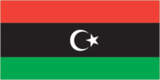
three horizontal bands of red (top), black (double width), and green with a white crescent and star centered on the black stripe; the National Transitional Council reintroduced this flag design of the former Kingdom of Libya (1951-1969) on 27 February 2011; it replaced the former all-green banner promulgated by the QADHAFI regime in 1977; the colors represent the three major regions of the country: red stands for Fezzan, black symbolizes Cyrenaica, and green denotes Tripolitania; the crescent and star represent Islam, the main religion of the country
Government type
in transition
Independence
24 December 1951 (from UN trusteeship)
International law organization participation
has not submitted an ICJ jurisdiction declaration; non-party state to the ICCt
International organization participation
ABEDA, AfDB, AFESD, AMF, AMU, AU, BDEAC, CAEU, COMESA, FAO, G-77, IAEA, IBRD, ICAO, ICC (NGOs), ICRM, IDA, IDB, IFAD, IFC, IFRCS, ILO, IMF, IMO, IMSO, Interpol, IOC, IOM, IPU, ISO, ITSO, ITU, LAS, LCBC, MIGA, NAM, OAPEC, OIC, OPCW, OPEC, PCA, UN, UNCTAD, UNESCO, UNHRC, UNIDO, UNOOSA, UNSMIL, UNWTO, UPU, WCO, WFTU (NGOs), WHO, WIPO, WMO, WTO (observer)
Judicial branch
- highest court(s)
- Libya's judicial system consists of a supreme court, central high courts (in Tripoli, Benghazi, and Sabha), and a series of lower courts; the judicial system is factious given the ongoing tension between Libya's eastern and western regions; since 2011, Libyan political factions and armed groups have targeted judges and courthouses
Legal system
Libya's post-revolution legal system is in flux and driven by state and non-state entities
Legislative branch
- description
- unicameral House of Representatives (Majlis Al Nuwab) or HoR (200 seats; members directly elected by majority vote; member term NA)
- election results
- percent of vote by party - NA; seats by party - NA; note - only 188 of the 200 seats were filled in the June 2014 election because of boycotts and lack of security at some polling stations; some elected members of the House of Representatives also boycotted the election
- elections
- last held on 25 June 2014
- note
- note: 32 seats are reserved for women
National anthem
- lyrics/music
- Al Bashir AL AREBI/Mohamad Abdel WAHAB
- name
- "Libya, Libya, Libya"
- note
- note: also known as "Ya Beladi" or "Oh, My Country!"; adopted 1951; readopted 2011 with some modification to the lyrics; during the QADHAFI years between 1969 and 2011, the anthem was "Allahu Akbar," (God is Great) a marching song of the Egyptian Army in the 1956 Suez War
National heritage
- selected World Heritage Site locales
- Archaeological Site of Cyrene; Archaeological Site of Leptis Magna, Archaeological Site of Sabratha; Rock-Art Sites of Tadrart Acacus; Old Town of Ghadamès
- total World Heritage Sites
- 5 (all cultural)
National holiday
Liberation Day, 23 October (2011)
National symbol(s)
star and crescent, hawk; national colors: red, black, green
Political parties
NA
Suffrage
18 years of age, universal
Economy
Agricultural products
- potatoes, watermelons, tomatoes, onions, dates, milk, olives, chicken, wheat, vegetables (2022)
- note
- note: top ten agricultural products based on tonnage
Budget
- expenditures
- $37.475 billion (2019 est.)
- revenues
- $28.005 billion (2019 est.)
Current account balance
- Current account balance 2019
- $4.817 billion (2019 est.)
- Current account balance 2020
- -$4.78 billion (2020 est.)
- Current account balance 2021
- $5.675 billion (2021 est.)
- note
- note: balance of payments - net trade and primary/secondary income in current dollars
Economic overview
upper middle-income, fossil fuel-based North African economy; 31% economic contraction due to COVID-19 and 2020 oil blockade; reduced government spending; central bank had to devalue currency; public wages are over 60% of expenditures
Exchange rates
- Currency
- Libyan dinars (LYD) per US dollar -
- Exchange rates 2019
- 1.398 (2019 est.)
- Exchange rates 2020
- 1.389 (2020 est.)
- Exchange rates 2021
- 4.514 (2021 est.)
- Exchange rates 2022
- 4.813 (2022 est.)
- Exchange rates 2023
- 4.813 (2023 est.)
Exports
- Exports 2019
- $29.326 billion (2019 est.)
- Exports 2020
- $9.537 billion (2020 est.)
- Exports 2021
- $32.38 billion (2021 est.)
- note
- note: balance of payments - exports of goods and services in current dollars
Exports - commodities
- crude petroleum, natural gas, gold, refined petroleum, scrap iron (2022)
- note
- note: top five export commodities based on value in dollars
Exports - partners
- Italy 26%, Spain 10%, Germany 9%, China 7%, France 6% (2022)
- note
- note: top five export partners based on percentage share of exports
GDP - composition, by end use
- exports of goods and services
- 68.6% (2023 est.)
- government consumption
- 31.8% (2023 est.)
- household consumption
- 26.1% (2023 est.)
- imports of goods and services
- -41.3% (2023 est.)
- investment in fixed capital
- 16.1% (2018 est.)
- investment in inventories
- -1.4% (2023 est.)
- note
- note: figures may not total 100% due to rounding or gaps in data collection
GDP - composition, by sector of origin
- agriculture
- 1.6% (2023 est.)
- industry
- 85% (2023 est.)
- note
- note: figures may not total 100% due to non-allocated consumption not captured in sector-reported data
- services
- 46.6% (2023 est.)
GDP (official exchange rate)
- $50.492 billion (2023 est.)
- note
- note: data in current dollars at official exchange rate
Imports
- Imports 2019
- $25.368 billion (2019 est.)
- Imports 2020
- $14.334 billion (2020 est.)
- Imports 2021
- $25.406 billion (2021 est.)
- note
- note: balance of payments - imports of goods and services in current dollars
Imports - commodities
- refined petroleum, cars, garments, broadcasting equipment, tobacco (2022)
- note
- note: top five import commodities based on value in dollars
Imports - partners
- Turkey 15%, China 12%, Italy 12%, Greece 10%, UAE 7% (2022)
- note
- note: top five import partners based on percentage share of imports
Industrial production growth rate
- 12.54% (2023 est.)
- note
- note: annual % change in industrial value added based on constant local currency
Industries
petroleum, petrochemicals, aluminum, iron and steel, food processing, textiles, handicrafts, cement
Inflation rate (consumer prices)
- Inflation rate (consumer prices) 2021
- 2.87% (2021 est.)
- Inflation rate (consumer prices) 2022
- 4.51% (2022 est.)
- Inflation rate (consumer prices) 2023
- 2.37% (2023 est.)
- note
- note: annual % change based on consumer prices
Labor force
- 2.398 million (2023 est.)
- note
- note: number of people ages 15 or older who are employed or seeking work
Public debt
- Public debt 2017
- 4.7% of GDP (2017 est.)
Real GDP (purchasing power parity)
- note
- note: data in 2021 dollars
- Real GDP (purchasing power parity) 2021
- $122.39 billion (2021 est.)
- Real GDP (purchasing power parity) 2022
- $124.026 billion (2022 est.)
- Real GDP (purchasing power parity) 2023
- $121.951 billion (2023 est.)
Real GDP growth rate
- note
- note: annual GDP % growth based on constant local currency
- Real GDP growth rate 2021
- 153.49% (2021 est.)
- Real GDP growth rate 2022
- 1.34% (2022 est.)
- Real GDP growth rate 2023
- -1.67% (2023 est.)
Real GDP per capita
- note
- note: data in 2021 dollars
- Real GDP per capita 2021
- $18,200 (2021 est.)
- Real GDP per capita 2022
- $18,200 (2022 est.)
- Real GDP per capita 2023
- $17,700 (2023 est.)
Remittances
- note
- note: personal transfers and compensation between resident and non-resident individuals/households/entities
- Remittances 2020
- 0% of GDP (2020 est.)
- Remittances 2021
- 0% of GDP (2021 est.)
- Remittances 2022
- 0% of GDP (2022 est.)
Reserves of foreign exchange and gold
- note
- note: holdings of gold (year-end prices)/foreign exchange/special drawing rights in current dollars
- Reserves of foreign exchange and gold 2021
- $82.262 billion (2021 est.)
- Reserves of foreign exchange and gold 2022
- $86.683 billion (2022 est.)
- Reserves of foreign exchange and gold 2023
- $92.427 billion (2023 est.)
Taxes and other revenues
51.6% (of GDP) (2017 est.)
Unemployment rate
- note
- note: % of labor force seeking employment
- Unemployment rate 2021
- 19.6% (2021 est.)
- Unemployment rate 2022
- 19.32% (2022 est.)
- Unemployment rate 2023
- 18.74% (2023 est.)
Youth unemployment rate (ages 15-24)
- female
- 68% (2023 est.)
- male
- 41.2% (2023 est.)
- note
- note: % of labor force ages 15-24 seeking employment
- total
- 49.4% (2023 est.)
Energy
Carbon dioxide emissions
- from consumed natural gas
- 18.072 million metric tonnes of CO2 (2022 est.)
- from petroleum and other liquids
- 31.68 million metric tonnes of CO2 (2022 est.)
- total emissions
- 49.751 million metric tonnes of CO2 (2022 est.)
Coal
- imports
- 300 metric tons (2022 est.)
Electricity
- consumption
- 24.674 billion kWh (2022 est.)
- imports
- 847.216 million kWh (2022 est.)
- installed generating capacity
- 10.517 million kW (2022 est.)
- transmission/distribution losses
- 6.457 billion kWh (2022 est.)
Electricity access
- electrification - total population
- 70% (2022 est.)
- electrification - urban areas
- 100%
Electricity generation sources
- fossil fuels
- 100% of total installed capacity (2022 est.)
Energy consumption per capita
- Total energy consumption per capita 2022
- 117.609 million Btu/person (2022 est.)
Natural gas
- consumption
- 9.212 billion cubic meters (2022 est.)
- exports
- 2.62 billion cubic meters (2022 est.)
- production
- 11.832 billion cubic meters (2022 est.)
- proven reserves
- 1.505 trillion cubic meters (2021 est.)
Petroleum
- crude oil estimated reserves
- 48.363 billion barrels (2021 est.)
- refined petroleum consumption
- 230,000 bbl/day (2022 est.)
- total petroleum production
- 1.245 million bbl/day (2023 est.)
Communications
Broadband - fixed subscriptions
- subscriptions per 100 inhabitants
- 5 (2020 est.)
- total
- 332,000 (2020 est.)
Broadcast media
state-funded and private TV stations; some provinces operate local TV stations; pan-Arab satellite TV stations are available; state-funded radio (2019)
Internet country code
.ly
Internet users
- percent of population
- 46.2% (2021 est.)
- total
- 3,095,400 (2021 est.)
Telecommunication systems
- domestic
- nearly 23 per 100 fixed-line and over 43 per 100 mobile-cellular subscriptions; service generally adequate (2021)
- general assessment
- political and security instability in Libya has disrupted its telecom sector; much of its infrastructure remains superior to that in most other African countries; rival operators fight for control; investment in fiber backbone and upgrades to international cables; limited LTE and 5G service; some satellite broadband; in 2021 Libya signed deals and projects with US firms to upgrade portions of its infrastructure, increasing the diversity of its telecommunications networks (2022)
- international
- country code - 218; landing points for LFON, EIG, Italy-Libya, Silphium and Tobrok-Emasaed submarine cable system connecting Europe, Africa, the Middle East and Asia; satellite earth stations - 4 Intelsat, Arabsat, and Intersputnik; microwave radio relay to Tunisia and Egypt; tropospheric scatter to Greece; participant in Medarabtel (2019)
Telephones - fixed lines
- subscriptions per 100 inhabitants
- 18 (2022 est.)
- total subscriptions
- 1.218 million (2022 est.)
Telephones - mobile cellular
- subscriptions per 100 inhabitants
- 205 (2022 est.)
- total subscriptions
- 13.94 million (2022 est.)
Transportation
Airports
66 (2024)
Civil aircraft registration country code prefix
5A
Merchant marine
- by type
- general cargo 2, oil tanker 13, other 81
- total
- 96 (2023)
National air transport system
- annual passenger traffic on registered air carriers
- 927,153 (2018)
- inventory of registered aircraft operated by air carriers
- 55
- number of registered air carriers
- 9 (2020)
Pipelines
882 km condensate, 3,743 km gas, 7,005 km oil (2013)
Ports
- key ports
- Al Burayqah, Az Zawiya, Banghazi, Mersa Tobruq, Mina Tarabulus (Tripoli)
- medium
- 2
- ports with oil terminals
- 10
- small
- 3
- total ports
- 14 (2024)
- very small
- 9
Roadways
- total
- 34,000 km (2021)
Military and Security
Military - note
the western-based GNU and the eastern-based LNA forces are separated by a fortified line of control running roughly from the coastal city of Sirte south to the vicinity of Al Jufra and Brak; Turkey has provided support to the GNU forces, including military trainers, ammunition, weapons, and aerial drones; Russia, the United Arab Emirates, and Egypt have been the main supporters of the LNA; both the LNA and the GNU forces have incorporated foreign fighters into their ranks (2024)
Military and security forces
- the Tripoli-based Government of National Unity (GNU) has access to various ground, air, and naval/coast guard forces comprised of a mix of formations and equipment from the QADHAFI regime, semi-regular and nominally integrated units, tribal armed groups/militias, civilian volunteers, and foreign private military contractors and mercenaries; the GNU has a Ministry of Defense, but has limited control over its security forcesthe self-styled Libyan National Army (LNA), under de facto LNA commander Khalifa HAFTER, also includes various ground, air, and naval forces comprised of semi-regular military personnel, militias, and foreign private military contractors and mercenaries; the LNA operates independently from the GNU and exerts influence throughout eastern, central, and southern Libya; some of the armed groups nominally under the LNA operate under their own command structures and engage in their own operations (2024)
- note
- note 1: the Stabilization Support Apparatus (SSA) is a state-funded militia established in January 2021 by the GNA; it is tasked with securing government buildings and officials, participating in combat operations, apprehending those suspected of national security crimes, and cooperating with other security bodies; other forces operating in western Libya include the Misrata Counter Terrorism Force, Special Deterrence Forces (aka Radaa), 444 Brigade, 111 Brigade, Nawasi Brigade, and the Joint Operations Force note 2: the national police force under the Ministry of Interior oversees internal security (with support from military forces under the Ministry of Defense), but much of Libya's security-related police work generally falls to informal armed groups, which receive government salaries but lack formal training, supervision, or consistent accountability
Military and security service personnel strengths
estimates not available
Military equipment inventories and acquisitions
- both the forces aligned with the GNU and the LNA are largely equipped with weapons of Russian or Soviet origin; in recent years, Turkey has the been the primary supplier of arms to the GNU, while the LNA has received quantities from Russia and the United Arab Emirates (2024)
- note
- note: Libya is under a UN-imposed arms embargo
Military expenditures
not available
Military service age and obligation
not available
Transnational Issues
Refugees and internally displaced persons
- IDPs
- 125,802 (conflict between pro-QADHAFI and anti-QADHAFI forces in 2011; post-QADHAFI tribal clashes 2014) (2023)
- refugees (country of origin)
- 11,623 (Syria) (refugees and asylum seekers), 8,302 (Eritrea) (2023); 6,293 (Sudan) (refugees and asylum seekers) (2024)
Terrorism
Terrorist group(s)
- Ansar al-Sharia groups; Islamic State of Iraq and ash-Sham - Libya (ISIS-L); al-Mulathamun Battalion (al-Mourabitoun); al-Qa'ida in the Islamic Maghreb (AQIM)
- note
- note: details about the history, aims, leadership, organization, areas of operation, tactics, targets, weapons, size, and sources of support of the group(s) appear(s) in the Terrorism reference guide
Environment
Air pollutants
- carbon dioxide emissions
- 50.56 megatons (2016 est.)
- methane emissions
- 45.76 megatons (2020 est.)
- particulate matter emissions
- 29.84 micrograms per cubic meter (2019 est.)
Climate
Mediterranean along coast; dry, extreme desert interior
Environment - current issues
desertification; limited natural freshwater resources; the Great Manmade River Project, the largest water development scheme in the world, brings water from large aquifers under the Sahara to coastal cities; water pollution is a significant problem; the combined impact of sewage, oil byproducts, and industrial waste threatens Libya's coast and the Mediterranean Sea
Environment - international agreements
- party to
- Biodiversity, Climate Change, Climate Change-Kyoto Protocol, Comprehensive Nuclear Test Ban, Desertification, Endangered Species, Hazardous Wastes, Marine Dumping-London Convention, Nuclear Test Ban, Ozone Layer Protection, Ship Pollution, Wetlands
- signed, but not ratified
- Climate Change-Paris Agreement, Law of the Sea
Food insecurity
- severe localized food insecurity
- due to civil insecurity, economic and political instability, and high food prices - a 2023 analysis states that about 300,000 people are estimated to be in need of humanitarian assistance in 2023; the country relies heavily on imports (up to 90%) to cover its cereal consumption requirements (mostly wheat for human consumption and barley for feed); between 2016 and 2020, the country sourced over 30% of its wheat imports from Ukraine, and 20% from the Russian Federation; almost 65% of total maize imports of 650,000 mt, and 50% of total barley imports of 1 million mt originated from Ukraine, making the Libya vulnerable to disruptions in shipments from the Black Sea region (2023)
Land use
- agricultural land
- 8.8% (2018 est.)
- agricultural land: arable land
- arable land: 1% (2018 est.)
- agricultural land: permanent crops
- permanent crops: 0.2% (2018 est.)
- agricultural land: permanent pasture
- permanent pasture: 7.6% (2018 est.)
- forest
- 0.1% (2018 est.)
- other
- 91.1% (2018 est.)
Major aquifers
Nubian Aquifer System, North Western Sahara Aquifer System, Murzuk-Djado Basin
Major watersheds (area sq km)
Internal (endorheic basin) drainage: Lake Chad (2,497,738 sq km)
Revenue from coal
0% of GDP (2018 est.)
Revenue from forest resources
0.06% of GDP (2018 est.)
Total renewable water resources
700 million cubic meters (2020 est.)
Total water withdrawal
- agricultural
- 4.85 billion cubic meters (2020 est.)
- industrial
- 280 million cubic meters (2020 est.)
- municipal
- 700 million cubic meters (2020 est.)
Urbanization
- rate of urbanization
- 1.45% annual rate of change (2020-25 est.)
- urban population
- 81.6% of total population (2023)
Waste and recycling
- municipal solid waste generated annually
- 2,147,596 tons (2011 est.)