2011 Edition
CIA World Factbook 2011 Archive (HTML)
Introduction
Background
Modern-day Laos has its roots in the ancient Lao kingdom of Lan Xang, established in the 14th Century under King FA NGUM. For 300 years Lan Xang had influence reaching into present-day Cambodia and Thailand, as well as over all of what is now Laos. After centuries of gradual decline, Laos came under the domination of Siam (Thailand) from the late 18th century until the late 19th century when it became part of French Indochina. The Franco-Siamese Treaty of 1907 defined the current Lao border with Thailand. In 1975, the Communist Pathet Lao took control of the government ending a six-century-old monarchy and instituting a strict socialist regime closely aligned to Vietnam. A gradual, limited return to private enterprise and the liberalization of foreign investment laws began in 1988. Laos became a member of ASEAN in 1997.
Geography
Area
- 236,800 sq km 230,800 sq km 6,000 sq km
- total
- 236,800 sq km
- water
- 6,000 sq km
Area - comparative
slightly larger than Utah
Climate
tropical monsoon; rainy season (May to November); dry season (December to April)
Coastline
0 km (landlocked)
Elevation extremes
- Mekong River 70 m Phu Bia 2,817 m
- highest point
- Phu Bia 2,817 m
- lowest point
- Mekong River 70 m
Environment - current issues
unexploded ordnance; deforestation; soil erosion; most of the population does not have access to potable water
Environment - international agreements
- Biodiversity, Climate Change, Climate Change-Kyoto Protocol, Desertification, Endangered Species, Environmental Modification, Law of the Sea, Ozone Layer Protection none of the selected agreements
- party to
- Biodiversity, Climate Change, Climate Change-Kyoto Protocol, Desertification, Endangered Species, Environmental Modification, Law of the Sea, Ozone Layer Protection
- signed, but not ratified
- none of the selected agreements
Freshwater withdrawal (domestic/industrial/agricultural)
- 3 cu km/yr (4%/6%/90%) 507 cu m/yr (2000)
- per capita
- 507 cu m/yr (2000)
- total
- 3 cu km/yr (4%/6%/90%)
Geographic coordinates
18 00 N, 105 00 E
Geography - note
landlocked; most of the country is mountainous and thickly forested; the Mekong River forms a large part of the western boundary with Thailand
Irrigated land
3,000 sq km (2008)
Land boundaries
- 5,083 km Burma 235 km, Cambodia 541 km, China 423 km, Thailand 1,754 km, Vietnam 2,130 km
- border countries
- Burma 235 km, Cambodia 541 km, China 423 km, Thailand 1,754 km, Vietnam 2,130 km
- total
- 5,083 km
Land use
- 4.01% 0.34% 95.65% (2005)
- arable land
- 4.01%
- other
- 95.65% (2005)
- permanent crops
- 0.34%
Location
Southeastern Asia, northeast of Thailand, west of Vietnam
Map references
Southeast Asia
Maritime claims
none (landlocked)
Natural hazards
floods, droughts
Natural resources
timber, hydropower, gypsum, tin, gold, gemstones
Terrain
mostly rugged mountains; some plains and plateaus
Total renewable water resources
333.6 cu km (2003)
People and Society
Age structure
- 36.7% (male 1,197,579/female 1,181,523) 59.6% (male 1,908,176/female 1,950,544) 3.7% (male 107,876/female 131,513) (2011 est.)
- 0-14 years
- 36.7% (male 1,197,579/female 1,181,523)
- 15-64 years
- 59.6% (male 1,908,176/female 1,950,544)
- 65 years and over
- 3.7% (male 107,876/female 131,513) (2011 est.)
Birth rate
26.13 births/1,000 population (2011 est.)
Children under the age of 5 years underweight
31.6% (2006)
Death rate
8.13 deaths/1,000 population (July 2011 est.)
Drinking water source
- urban: 72% of population rural: 51% of population total: 57% of population urban: 28% of population rural: 49% of population total: 43% of population (2008)
- rural
- 49% of population
- total
- 43% of population (2008)
- urban
- 28% of population
Education expenditures
2.3% of GDP (2008)
Ethnic groups
Lao 55%, Khmou 11%, Hmong 8%, other (over 100 minor ethnic groups) 26% (2005 census)
Health expenditures
6.5% of GDP (2009)
HIV/AIDS - adult prevalence rate
0.2% (2009 est.)
HIV/AIDS - deaths
fewer than 200 (2009 est.)
HIV/AIDS - people living with HIV/AIDS
8,500 (2009 est.)
Hospital bed density
1.2 beds/1,000 population (2005)
Infant mortality rate
- 59.46 deaths/1,000 live births 65.49 deaths/1,000 live births 53.18 deaths/1,000 live births (2011 est.)
- female
- 53.18 deaths/1,000 live births (2011 est.)
- total
- 59.46 deaths/1,000 live births
Languages
Lao (official), French, English, various ethnic languages
Life expectancy at birth
- 62.39 years 60.5 years 64.36 years (2011 est.)
- female
- 64.36 years (2011 est.)
- total population
- 62.39 years
Literacy
- age 15 and over can read and write 73% 83% 63% (2005 Census)
- definition
- age 15 and over can read and write
- female
- 63% (2005 Census)
- male
- 83%
- total population
- 73%
Major cities - population
VIENTIANE (capital) 799,000 (2009)
Major infectious diseases
- very high bacterial and protozoal diarrhea, hepatitis A, and typhoid fever dengue fever and malaria highly pathogenic H5N1 avian influenza has been identified in this country; it poses a negligible risk with extremely rare cases possible among US citizens who have close contact with birds (2008) (2009)
- degree of risk
- very high
- food or waterborne diseases
- bacterial and protozoal diarrhea, hepatitis A, and typhoid fever
- vectorborne diseases
- dengue fever and malaria
Maternal mortality rate
580 deaths/100,000 live births (2008)
Median age
- 21 years 20.7 years 21.3 years (2011 est.)
- female
- 21.3 years (2011 est.)
- male
- 20.7 years
- total
- 21 years
Nationality
- Lao(s) or Laotian(s) Lao or Laotian
- adjective
- Lao or Laotian
- noun
- Lao(s) or Laotian(s)
Net migration rate
-1.16 migrant(s)/1,000 population (2011 est.)
Obesity - adult prevalence rate
1.2% (2000)
Physicians density
0.272 physicians/1,000 population (2005)
Population
6,477,211 (July 2011 est.)
Population growth rate
1.684% (2011 est.)
Religions
Buddhist 67%, Christian 1.5%, other and unspecified 31.5% (2005 census)
Sanitation facility access
- urban: 86% of population rural: 38% of population total: 53% of population urban: 14% of population rural: 62% of population total: 47% of population (2008)
- rural
- 62% of population
- total
- 47% of population (2008)
- urban
- 14% of population
School life expectancy (primary to tertiary education)
- 9 years 10 years 9 years (2008)
- female
- 9 years (2008)
- male
- 10 years
- total
- 9 years
Sex ratio
- 1.04 male(s)/female 1.01 male(s)/female 0.98 male(s)/female 0.75 male(s)/female 0.98 male(s)/female (2011 est.)
- 15-64 years
- 0.98 male(s)/female
- 65 years and over
- 0.75 male(s)/female
- at birth
- 1.04 male(s)/female
- total population
- 0.98 male(s)/female (2011 est.)
- under 15 years
- 1.01 male(s)/female
Total fertility rate
3.14 children born/woman (2011 est.)
Urbanization
- 33% of total population (2010) 4.9% annual rate of change (2010-15 est.)
- rate of urbanization
- 4.9% annual rate of change (2010-15 est.)
- urban population
- 33% of total population (2010)
Government
Administrative divisions
16 provinces (khoueng, singular and plural) and 1 capital city* (nakhon luang, singular and plural); Attapu, Bokeo, Bolikhamxai, Champasak, Houaphan, Khammouan, Louangnamtha, Louangphrabang, Oudomxai, Phongsali, Salavan, Savannakhet, Viangchan (Vientiane)*, Viangchan, Xaignabouli, Xekong, Xiangkhoang
Capital
- Vientiane (Viangchan) 17 58 N, 102 36 E UTC+7 (12 hours ahead of Washington, DC during Standard Time)
- geographic coordinates
- 17 58 N, 102 36 E
- name
- Vientiane (Viangchan)
- time difference
- UTC+7 (12 hours ahead of Washington, DC during Standard Time)
Constitution
promulgated 14 August 1991; amended in 2003
Country name
- Lao People's Democratic Republic Laos Sathalanalat Paxathipatai Paxaxon Lao Pathet Lao (unofficial)
- conventional long form
- Lao People's Democratic Republic
- conventional short form
- Laos
- local long form
- Sathalanalat Paxathipatai Paxaxon Lao
- local short form
- Pathet Lao (unofficial)
Diplomatic representation from the US
- Ambassador Karen B. STEWART 19 Rue Bartholonie, That Dam, Vientiane American Embassy Vientiane, APO AP 96546 [856] 21-26-7000 [856] 21-26-7190
- chief of mission
- Ambassador Karen B. STEWART
- embassy
- 19 Rue Bartholonie, That Dam, Vientiane
- FAX
- [856] 21-26-7190
- mailing address
- American Embassy Vientiane, APO AP 96546
- telephone
- [856] 21-26-7000
Diplomatic representation in the US
- Ambassador SENG Soukhathivong 2222 S Street NW, Washington, DC 20008 [1] (202) 332-6416 [1] (202) 332-4923
- chancery
- 2222 S Street NW, Washington, DC 20008
- chief of mission
- Ambassador SENG Soukhathivong
- FAX
- [1] (202) 332-4923
- telephone
- [1] (202) 332-6416
Executive branch
- President Lt. Gen. CHOUMMALI Saignason (since 8 June 2006); Vice President BOUN-GNANG Volachit (since 8 June 2006) Prime Minister THONGSING Thammavong (since 24 December 2010); First Deputy Prime Minister Maj. Gen. ASANG Laoli (since May 2002), Prime Ministers Maj. Gen. DOUANGCHAI Phichit (since 8 June 2006), SOMSAVAT Lengsavat (since 26 February 1998), and THONGLOUN Sisoulit (since 27 March 2001) Ministers appointed by president, approved by National Assembly president and vice president elected by National Assembly for five-year terms; election last held on 8 June 2006 (next to be held in 2011); prime minister nominated by the president and elected by the National Assembly for five-year term CHOUMMALI Saignason elected president; BOUN-GNANG Volachit elected vice president; percent of National Assembly vote - 100%; BOUASONE Bouphavanh elected prime minister; percent of National Assembly vote - 97%
- cabinet
- Ministers appointed by president, approved by National Assembly
- chief of state
- President Lt. Gen. CHOUMMALI Saignason (since 8 June 2006); Vice President BOUN-GNANG Volachit (since 8 June 2006)
- election results
- CHOUMMALI Saignason elected president; BOUN-GNANG Volachit elected vice president; percent of National Assembly vote - 100%; BOUASONE Bouphavanh elected prime minister; percent of National Assembly vote - 97%
- elections
- president and vice president elected by National Assembly for five-year terms; election last held on 8 June 2006 (next to be held in 2011); prime minister nominated by the president and elected by the National Assembly for five-year term
- head of government
- Prime Minister THONGSING Thammavong (since 24 December 2010); First Deputy Prime Minister Maj. Gen. ASANG Laoli (since May 2002), Prime Ministers Maj. Gen. DOUANGCHAI Phichit (since 8 June 2006), SOMSAVAT Lengsavat (since 26 February 1998), and THONGLOUN Sisoulit (since 27 March 2001)
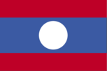
Flag description
three horizontal bands of red (top), blue (double width), and red with a large white disk centered in the blue band; the red bands recall the blood shed for liberation; the blue band represents the Mekong River and prosperity; the white disk symbolizes the full moon against the Mekong River, but also signifies the unity of the people under the Pathet Lao, as well as the country's bright future
Government type
Communist state
Independence
19 July 1949 (from France)
International law organization participation
has not submitted an ICJ jurisdiction declaration; non-party state to the ICCt
International organization participation
ADB, ARF, ASEAN, CP, EAS, FAO, G-77, IAEA, IBRD, ICAO, ICRM, IDA, IFAD, IFC, IFRCS, ILO, IMF, Interpol, IOC, IPU, ISO (subscriber), ITU, MIGA, NAM, OIF, OPCW, PCA, UN, UNCTAD, UNESCO, UNIDO, UNWTO, UPU, WCO, WFTU, WHO, WIPO, WMO, WTO (observer)
Judicial branch
People's Supreme Court, People's Provincial and Municipal Courts, People's District Courts, and Military Courts the president of the People's Supreme Court is elected by the National Assembly on the recommendation of the National Assembly Standing Committee; the vice president of the People's Supreme Court and the judges are appointed by the National Assembly Standing Committee
Legal system
civil law system similar in form to the French system
Legislative branch
- unicameral National Assembly (132 seats; members elected by popular vote from a list of candidates selected by the Lao People's Revolutionary Party to serve five-year terms) last held on 30 April 2011 (next to be held in 2016) percent of vote by party - NA; seats by party - LPRP 128, independents 4
- election results
- percent of vote by party - NA; seats by party - LPRP 128, independents 4
- elections
- last held on 30 April 2011 (next to be held in 2016)
National anthem
- "Pheng Xat Lao" (Hymn of the Lao People) SISANA Sisane/THONGDY Sounthonevichit music adopted 1945, lyrics adopted 1975; the anthem's lyrics were changed following the 1975 Communist revolution that overthrew the monarchy
- lyrics/music
- SISANA Sisane/THONGDY Sounthonevichit
- name
- "Pheng Xat Lao" (Hymn of the Lao People)
National holiday
Republic Day, 2 December (1975)
National symbol(s)
elephant
Political parties and leaders
Lao People's Revolutionary Party or LPRP [CHOUMMALI Saignason]; other parties proscribed
Political pressure groups and leaders
NA
Suffrage
18 years of age; universal
Economy
Agriculture - products
sweet potatoes, vegetables, corn, coffee, sugarcane, tobacco, cotton, tea, peanuts, rice; water buffalo, pigs, cattle, poultry
Budget
- $1.136 billion $1.338 billion (2010 est.)
- expenditures
- $1.338 billion (2010 est.)
- revenues
- $1.136 billion
Budget surplus (+) or deficit (-)
-3.2% of GDP (2010 est.)
Central bank discount rate
4.3% (31 December 2010) 4% (31 December 2009)
Commercial bank prime lending rate
22.613% (31 December 2010) 24.775% (31 December 2009 est.)
Current account balance
-$195 million (2010 est.) $9.3 million (2009 est.)
Debt - external
$4.635 billion (31 December 2010 est.) $4.721 billion (31 December 2009 est.)
Distribution of family income - Gini index
36.7 (2008) 34.6 (2002)
Economy - overview
The government of Laos, one of the few remaining one-party Communist states, began decentralizing control and encouraging private enterprise in 1986. The results, starting from an extremely low base, were striking - growth averaged 6% per year from 1988-2008 except during the short-lived drop caused by the Asian financial crisis that began in 1997. Despite this high growth rate, Laos remains a country with an underdeveloped infrastructure, particularly in rural areas. It has a rudimentary, but improving, road system, and limited external and internal telecommunications. China has signed a deal with the Lao to build a high speed rail system in the country. Construction on the $7 billion project is slated to begin in April 2011 and will take five years. Electricity is available in urban areas and in many rural districts. Subsistence agriculture, dominated by rice cultivation in lowland areas, accounts for about 30% of GDP and 75% of total employment. The government in FY09/10 received $586 million from international donors. Economic growth has reduced official poverty rates from 46% in 1992 to 26% in 2010. The economy has benefited from high foreign investment in hydropower, mining, and construction. Laos gained Normal Trade Relations status with the US in 2004, and is taking steps required to join the World Trade Organization, such as reforming import licensing. Related trade policy reforms will improve the business environment. On the fiscal side, Laos initiated a VAT tax system in 2010. Simplified investment procedures and expanded bank credits for small farmers and small entrepreneurs will improve Lao's economic prospects. The government appears committed to raising the country's profile among investors. The World Bank has declared that Laos's goal of graduating from the UN Development Program's list of least-developed countries by 2020 is achievable. According Laotian officials, the 7th Socio-Economic Development Plan for 2011-15 will outline efforts to achieve Millennium Development Goals.
Electricity - consumption
2.23 billion kWh (2010 est.)
Electricity - exports
341 million kWh (2010 est.)
Electricity - imports
999 million kWh (2010 est.)
Electricity - production
1.553 billion kWh (2010 est.)
Exchange rates
kips (LAK) per US dollar - 8,320.27 (2010) 8,516.04 (2009) 8,760.69 (2008) 9,658 (2007) 10,235 (2006)
Exports
$1.474 billion (2010 est.) $1.053 billion (2009 est.)
Exports - commodities
wood products, coffee, electricity, tin, copper, gold
Exports - partners
Thailand 31.1%, China 23%, Vietnam 12.9% (2010)
GDP - composition by sector
- 29.2% 32.4% 38.3% (2010 est.)
- agriculture
- 29.2%
- industry
- 32.4%
- services
- 38.3% (2010 est.)
GDP - per capita (PPP)
$2,500 (2010 est.) $2,300 (2009 est.) $2,200 (2008 est.) data are in 2010 US dollars
GDP - real growth rate
7.7% (2010 est.) 7.6% (2009 est.) 7.8% (2008 est.)
GDP (official exchange rate)
$6.341 billion (2010 est.)
GDP (purchasing power parity)
$15.69 billion (2010 est.) $14.56 billion (2009 est.) $13.54 billion (2008 est.) data are in 2010 US dollars
Household income or consumption by percentage share
- 3.3% 30.3% (2008)
- highest 10%
- 30.3% (2008)
- lowest 10%
- 3.3%
Imports
$2.06 billion (2010 est.) $1.461 billion (2009 est.)
Imports - commodities
machinery and equipment, vehicles, fuel, consumer goods
Imports - partners
Thailand 65.6%, China 14.6%, Vietnam 6.6% (2010)
Industrial production growth rate
17.7% (2010 est.)
Industries
copper, tin, gold, and gypsum mining; timber, electric power, agricultural processing, construction, garments, cement, tourism
Inflation rate (consumer prices)
5.7% (2010 est.) 0% (2009 est.)
Labor force
3.69 million (2010 est.)
Labor force - by occupation
- 75.1% NA (2010 est.)
- agriculture
- 75.1%
- industry and services
- NA (2010 est.)
Natural gas - consumption
0 cu m (2009 est.)
Natural gas - exports
0 cu m (2009 est.)
Natural gas - imports
0 cu m (2009 est.)
Natural gas - production
0 cu m (2009 est.)
Natural gas - proved reserves
0 cu m (1 January 2011 est.)
Oil - consumption
3,000 bbl/day (2010 est.)
Oil - exports
0 bbl/day (2009 est.)
Oil - imports
1,918 bbl/day (2010 est.)
Oil - production
0 bbl/day (2010 est.)
Oil - proved reserves
0 bbl (1 January 2011 est.)
Population below poverty line
26% (2010 est.)
Reserves of foreign exchange and gold
$713.4 million (31 December 2010 est.) $618.6 million (31 December 2009 est.)
Stock of broad money
$2.643 billion (31 December 2010 est.) $1.805 billion (31 December 2009 est.)
Stock of domestic credit
$1.95 billion (31 December 2010 est.) $1.22 billion (31 December 2009 est.)
Stock of narrow money
$787.9 million (31 December 2010 est.) $564.6 million (31 December 2009 est.)
Taxes and other revenues
17.9% of GDP (2010 est.)
Unemployment rate
2.5% (2009 est.) 2.4% (2005 est.)
Communications
Broadcast media
2 television stations operating out of Vientiane - 1 government-operated and the other jointly-owned by the government and a Thai company; roughly 15 provincial stations operating with nearly all programming relayed via satellite from the government-operated station in Vientiane; relays from Hanoi provide access to a Vietnamese television station; broadcasts available from stations in Thailand and Vietnam in border areas; multi-channel satellite and cable TV systems provide access to a wide range of foreign stations; state-controlled radio with state-operated Lao National Radio (LNR) broadcasting on 5 frequencies - 1 AM, 2 SW, and 2 FM; LNR's AM and FM programs are relayed via satellite constituting a large part of the programming schedules of the provincial radio stations; Thai radio broadcasts available in border areas and transmissions of multiple international broadcasters are also accessible (2008)
Internet country code
.la
Internet hosts
1,468 (2010)
Internet users
300,000 (2009)
Telephone system
- service to general public is poor but improving; the government relies on a radiotelephone network to communicate with remote areas multiple service providers; mobile cellular usage growing very rapidly country code - 856; satellite earth station - 1 Intersputnik (Indian Ocean region) and a second to be developed by China (2008)
- domestic
- multiple service providers; mobile cellular usage growing very rapidly
- general assessment
- service to general public is poor but improving; the government relies on a radiotelephone network to communicate with remote areas
- international
- country code - 856; satellite earth station - 1 Intersputnik (Indian Ocean region) and a second to be developed by China (2008)
Telephones - main lines in use
103,100 (2010)
Telephones - mobile cellular
4.003 million (2010)
Transportation
Airports
41 (2010)
Airports - with paved runways
- 3 (2010)
- 1,524 to 2,437 m
- 4
- 2,438 to 3,047 m
- 2
- 914 to 1,523 m
- 3 (2010)
- total
- 9
Airports - with unpaved runways
- 21 (2010)
- 1,524 to 2,437 m
- 2
- 914 to 1,523 m
- 9
- total
- 32
- under 914 m
- 21 (2010)
Merchant marine
- cargo 1 (2008)
- total
- 1
Pipelines
refined products 540 km (2010)
Roadways
- 39,568 km 530 km 39,038 km (2009)
- total
- 39,568 km
- unpaved
- 39,038 km (2009)
Waterways
4,600 km (primarily on the Mekong River and its tributaries; 2,900 additional km are intermittently navigable by craft drawing less than 0.5 m) (2010)
Military and Security
Manpower available for military service
- 1,574,362 1,607,856 (2010 est.)
- females age 16-49
- 1,607,856 (2010 est.)
- males age 16-49
- 1,574,362
Manpower fit for military service
- 1,111,629 1,190,035 (2010 est.)
- females age 16-49
- 1,190,035 (2010 est.)
- males age 16-49
- 1,111,629
Manpower reaching militarily significant age annually
- 71,400 73,038 (2010 est.)
- female
- 73,038 (2010 est.)
- male
- 71,400
Military - note
serving one of the world's least developed countries, the Lao People's Armed Forces (LPAF) is small, poorly funded, and ineffectively resourced; its mission focus is border and internal security, primarily in countering ethnic Hmong insurgent groups; together with the Lao People's Revolutionary Party and the government, the Lao People's Army (LPA) is the third pillar of state machinery, and as such is expected to suppress political and civil unrest and similar national emergencies, but the LPA also has upgraded skills to respond to avian influenza outbreaks; there is no perceived external threat to the state and the LPA maintains strong ties with the neighboring Vietnamese military (2008)
Military branches
- Lao People's Armed Forces (LPAF): Lao People's Army (LPA; includes Riverine Force), Air Force (2011)
- Lao People's Armed Forces (LPAF)
- Lao People's Army (LPA; includes Riverine Force), Air Force (2011)
Military expenditures
0.5% of GDP (2006)
Military service age and obligation
18 years of age for compulsory military service; minimum 18-month service obligation (2010)
Transnational Issues
Disputes - international
Southeast Asian states have enhanced border surveillance to check the spread of avian flu; talks continue on completion of demarcation with Thailand but disputes remain over islands in the Mekong River; concern among Mekong Commission members that China's construction of dams on the Mekong River will affect water levels; Cambodia is concerned about Laos' extensive upstream dam construction
Illicit drugs
estimated opium poppy cultivation in 2008 was 1,900 hectares, about a 73% increase from 2007; estimated potential opium production in 2008 more than tripled to 17 metric tons; unsubstantiated reports of domestic methamphetamine production; growing domestic methamphetamine problem (2007)