1992 Edition
CIA World Factbook 1992 (Project Gutenberg)
Geography
Climate
tropical monsoon; rainy season (May to November); dry season (December to April)
Coastline
none - landlocked
Comparative area
slightly larger than Utah
Disputes
boundary dispute with Thailand
Environment
deforestation; soil erosion; subject to floods
Land area
230,800 km2
Land boundaries
5,083 km; Burma 235 km, Cambodia 541 km, China 423 km, Thailand 1,754 km, Vietnam 2,130 km
Land use
arable land 4%; permanent crops NEGL%; meadows and pastures 3%; forest and woodland 58%; other 35%; includes irrigated 1%
Maritime claims
none - landlocked
Natural resources
timber, hydropower, gypsum, tin, gold, gemstones
Note
landlocked
Terrain
mostly rugged mountains; some plains and plateaus
Total area
236,800 km2
People and Society
Birth rate
44 births/1,000 population (1992)
Death rate
16 deaths/1,000 population (1992)
Ethnic divisions
Lao 50%, Phoutheung (Kha) 15%, tribal Thai 20%, Meo, Hmong, Yao, and other 15%
Infant mortality rate
107 deaths/1,000 live births (1992)
Labor force
1-1.5 million; 85-90% in agriculture (est.)
Languages
Lao (official), French, and English
Life expectancy at birth
49 years male, 52 years female (1992)
Literacy
84% (male 92%, female 76%) age 15 to 45 can read and write (1985 est.)
Nationality
noun - Lao(s) or Laotian(s); adjective - Lao or Laotian
Net migration rate
0 migrants/1,000 population (1992)
Organized labor
Lao Federation of Trade Unions is subordinate to the Communist party
Population
4,440,213 (July 1992), growth rate 2.9% (1992)
Religions
Buddhist 85%, animist and other 15%
Total fertility rate
6.3 children born/woman (1992)
Government
Administrative divisions
16 provinces (khoueng, singular and plural) and 1 municipality* (kampheng nakhon, singular and plural); Attapu, Bokeo, Bolikhamsai, Champasak, Houaphan, Khammouan, Louang Namtha, Louangphrabang, Oudomxai, Phongsali, Saravan, Savannakhet, Sekong, Vientiane, Vientiane*, Xaignabouri, Xiangkhoang
Capital
Vientiane
Chief of State
President KAYSONE PHOMVIHAN (since 15 August 1991)
Constitution
promulgated August 1991
Diplomatic representation
Charge d'Affaires LINTHONG PHETSAVAN; Chancery at 2222 S Street NW, Washington, DC 20008; telephone (202) 332-6416 or 6417 US: Charge d'Affaires Charles B. SALMON, Jr.; Embassy at Rue Bartholonie, Vientiane (mailing address is B. P. 114, Vientiane, or AMEMB, Box V, APO AP 96546); telephone (856) 2220, 2357, 2384; FAX (856) 4675
Executive branch
president, chairman and two vice chairmen of the Council of Ministers, Council of Ministers (cabinet)
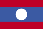
Flag
three horizontal bands of red (top), blue (double width), and red with a large white disk centered in the blue band
Head of Government
Chairman of the Council of Ministers Gen. KHAMTAI SIPHANDON (since 15 August 1991)
Independence
19 July 1949 (from France)
Judicial branch
People's Supreme Court
Legal system
based on civil law system; has not accepted compulsory ICJ jurisdiction
Legislative branch
Supreme People's Assembly
Long-form name
Lao People's Democratic Republic
Member of
ACCT (associate), AsDB, CP, ESCAP, FAO, G-77, IBRD, ICAO, IDA, IFAD, ILO, IMF, INTERPOL, IOC, ITU, LORCS, NAM, PCA, UN, UNCTAD, UNESCO, UNIDO, UPU, WFTU, WHO, WMO, WTO
National holiday
National Day (proclamation of the Lao People's Democratic Republic), 2 December (1975)
Other political or pressure groups
non-Communist political groups moribund; most leaders have fled the country
Political parties and leaders
Lao People's Revolutionary Party (LPRP), KAYSONE PHOMVIHAN, party chairman; includes Lao Patriotic Front and Alliance Committee of Patriotic Neutralist Forces; other parties moribund
Suffrage
universal at age 18
Supreme People's Assembly
last held on 26 March 1989 (next to be held NA); results - percent of vote by party NA; seats - (79 total) number of seats by party NA
Type
Communist state
Economy
Agriculture
accounts for 60% of GDP and employs most of the work force; subsistence farming predominates; normally self-sufficient in nondrought years; principal crops - rice (80% of cultivated land), sweet potatoes, vegetables, corn, coffee, sugarcane, cotton; livestock - buffaloes, hogs, cattle, chicken
Budget
revenues $83 million; expenditures $188.5 million, including capital expenditures of $94 million (1990 est.)
Currency
new kip (plural - kips); 1 new kip (NK) = 100 at
Economic aid
US commitments, including Ex-Im (FY70-79), $276 million; Western (non-US) countries, ODA and OOF bilateral commitments (1970-89), $605 million; Communist countries (1970-89), $995 million
Electricity
226,000 kW capacity; 1,100 million kWh produced, 270 kWh per capita (1991)
Exchange rates
new kips (NK) per US$1 - 710 (May 1992), 710 (December 1991), 700 (September 1990), 576 (1989), 385 (1988), 200 (1987)
Exports
$72 million (f.o.b., 1990 est.) commodities: electricity, wood products, coffee, tin partners: Thailand, Malaysia, Vietnam, USSR, US, China
External debt
$1.1 billion (1990 est.)
Fiscal year
1 July - 30 June
GDP
exchange rate conversion - $800 million, per capita $200; real growth rate 4% (1991)
Illicit drugs
illicit producer of cannabis, opium poppy for the international drug trade, third-largest opium producer
Imports
$238 million (c.i.f., 1990 est.) commodities: food, fuel oil, consumer goods, manufactures partners: Thailand, USSR, Japan, France, Vietnam, China
Industrial production
growth rate 12% (1991 est.); accounts for about 18% of GDP (1991 est.)
Industries
tin and gypsum mining, timber, electric power, agricultural processing, construction
Inflation rate (consumer prices)
10.4% (December 1991)
Overview
One of the world's poorest nations, Laos has had a Communist centrally planned economy with government ownership and control of productive enterprises of any size. In recent years, however, the government has been decentralizing control and encouraging private enterprise. Laos is a landlocked country with a primitive infrastructure; that is, it has no railroads, a rudimentary road system, limited external and internal telecommunications, and electricity available in only a limited area. Subsistence agriculture is the main occupation, accounting for over 60% of GDP and providing about 85-90% of total employment. The predominant crop is rice. For the foreseeable future the economy will continue to depend for its survival on foreign aid from the IMF and other international sources; aid from the former USSR and Eastern Europe has been cut sharply.
Unemployment rate
21% (1989 est.)
Communications
Airports
57 total, 47 usable; 8 with permanent-surface runways; none with runways over 3,659 m; 1 with runways 2,440-3,659 m; 14 with runways 1,220-2,439 m
Highways
about 27,527 km total; 1,856 km bituminous or bituminous treated; 7,451 km gravel, crushed stone, or improved earth; 18,220 km unimproved earth and often impassable during rainy season mid-May to mid-September
Inland waterways
about 4,587 km, primarily Mekong and tributaries; 2,897 additional kilometers are sectionally navigable by craft drawing less than 0.5 m
Pipelines
petroleum products 136 km
Ports
none
Railroads
none
Telecommunications
service to general public considered poor; radio communications network provides generally erratic service to government users; 7,390 telephones (1986); broadcast stations - 10 AM, no FM, 1 TV; 1 satellite earth station
Military and Security
Branches
Lao People's Army (LPA; including naval, aviation, and militia elements), Air Force, National Police Department
Defense expenditures
exchange rate conversion - $NA, NA% of GDP
Manpower availability
males 15-49, 946,289; 509,931 fit for military service; 45,232 reach military age (18) annually; conscription age NA