2012 Edition
CIA World Factbook 2012 Archive (HTML)
Introduction
Background
The Gilbert Islands became a British protectorate in 1892 and a colony in 1915; they were captured by the Japanese in the Pacific War in 1941. The islands of Makin and Tarawa were the sites of major US amphibious victories over entrenched Japanese garrisons in 1943. The Gilbert Islands were granted self-rule by the UK in 1971 and complete independence in 1979 under the new name of Kiribati. The US relinquished all claims to the sparsely inhabited Phoenix and Line Island groups in a 1979 treaty of friendship with Kiribati.
Geography
Area
- 811 sq km 811 sq km 0 sq km includes three island groups - Gilbert Islands, Line Islands, Phoenix Islands
- total
- 811 sq km
- water
- 0 sq km
Area - comparative
four times the size of Washington, DC
Climate
tropical; marine, hot and humid, moderated by trade winds
Coastline
1,143 km
Elevation extremes
- Pacific Ocean 0 m unnamed elevation on Banaba 81 m
- highest point
- unnamed elevation on Banaba 81 m
- lowest point
- Pacific Ocean 0 m
Environment - current issues
heavy pollution in lagoon of south Tarawa atoll due to heavy migration mixed with traditional practices such as lagoon latrines and open-pit dumping; ground water at risk
Environment - international agreements
- Biodiversity, Climate Change, Climate Change-Kyoto Protocol, Desertification, Hazardous Wastes, Law of the Sea, Marine Dumping, Ozone Layer Protection, Whaling none of the selected agreements
- party to
- Biodiversity, Climate Change, Climate Change-Kyoto Protocol, Desertification, Hazardous Wastes, Law of the Sea, Marine Dumping, Ozone Layer Protection, Whaling
- signed, but not ratified
- none of the selected agreements
Geographic coordinates
1 25 N, 173 00 E
Geography - note
21 of the 33 islands are inhabited; Banaba (Ocean Island) in Kiribati is one of the three great phosphate rock islands in the Pacific Ocean - the others are Makatea in French Polynesia, and Nauru; Kiribati is the only country in the world to fall into all four hemispheres (northern, southern, eastern, and western)
Irrigated land
NA
Land boundaries
0 km
Land use
- 2.74% 47.95% 49.31% (2005)
- arable land
- 2.74%
- other
- 49.31% (2005)
- permanent crops
- 47.95%
Location
Oceania, group of 33 coral atolls in the Pacific Ocean, straddling the Equator, as well as the International Date Line; the capital Tarawa is about half way between Hawaii and Australia
Map references
Oceania
Maritime claims
- 12 nm 200 nm
- exclusive economic zone
- 200 nm
- territorial sea
- 12 nm
Natural hazards
typhoons can occur any time, but usually November to March; occasional tornadoes; low level of some of the islands make them sensitive to changes in sea level
Natural resources
phosphate (production discontinued in 1979)
Terrain
mostly low-lying coral atolls surrounded by extensive reefs
People and Society
Age structure
- 33.1% (male 17,196/ female 16,561) 63.1% (male 31,289/ female 33,082) 3.8% (male 1,512/ female 2,358) (2012 est.)
- 0-14 years
- 33.1% (male 17,196/ female 16,561)
- 15-64 years
- 63.1% (male 31,289/ female 33,082)
- 65 years and over
- 3.8% (male 1,512/ female 2,358) (2012 est.)
Birth rate
22.45 births/1,000 population (2012 est.)
Death rate
7.31 deaths/1,000 population (July 2012 est.)
Education expenditures
NA
Ethnic groups
Micronesian 98.8%, other 1.2% (2000 census)
Health expenditures
3.3% of GDP (2009)
HIV/AIDS - adult prevalence rate
NA
HIV/AIDS - deaths
NA
HIV/AIDS - people living with HIV/AIDS
NA
Hospital bed density
1.8 beds/1,000 population (2008)
Infant mortality rate
- 37.68 deaths/1,000 live births 38.91 deaths/1,000 live births 36.38 deaths/1,000 live births (2012 est.)
- female
- 36.38 deaths/1,000 live births (2012 est.)
- total
- 37.68 deaths/1,000 live births
Languages
I-Kiribati, English (official)
Life expectancy at birth
- 64.76 years 62.37 years 67.26 years (2012 est.)
- female
- 67.26 years (2012 est.)
- total population
- 64.76 years
Literacy
NA
Major cities - population
TARAWA (capital) 43,000 (2009)
Maternal mortality rate
9 deaths/100,000 live births (2008)
Median age
- 22.9 years 22.1 years 23.7 years (2012 est.)
- female
- 23.7 years (2012 est.)
- male
- 22.1 years
- total
- 22.9 years
Nationality
- I-Kiribati (singular and plural) I-Kiribati
- adjective
- I-Kiribati
- noun
- I-Kiribati (singular and plural)
Net migration rate
-2.85 migrant(s)/1,000 population (2012 est.)
Obesity - adult prevalence rate
50.6% (2006)
Physicians density
0.297 physicians/1,000 population (2006)
Population
101,998 (July 2012 est.)
Population growth rate
1.228% (2012 est.)
Religions
Roman Catholic 55%, Protestant 36%, Mormon 3.1%, Baha'i 2.2%, Seventh-Day Adventist 1.9%, other 1.8% (2005 census)
Sanitation facility access
- urban: 47% of population rural: 22% of population total: 33% of population urban: 53% of population rural: 78% of population total: 67% of population
- rural
- 78% of population
- total
- 67% of population
- urban
- 53% of population
School life expectancy (primary to tertiary education)
- 12 years 12 years 13 years (2008)
- female
- 13 years (2008)
- male
- 12 years
- total
- 12 years
Sex ratio
- 1.05 male(s)/female 1.04 male(s)/female 0.95 male(s)/female 0.64 male(s)/female 0.96 male(s)/female (2011 est.)
- 15-64 years
- 0.95 male(s)/female
- 65 years and over
- 0.64 male(s)/female
- at birth
- 1.05 male(s)/female
- total population
- 0.96 male(s)/female (2011 est.)
- under 15 years
- 1.04 male(s)/female
Total fertility rate
2.71 children born/woman (2012 est.)
Unemployment, youth ages 15-24
- 11.3% 11.8% 10% (2005)
- female
- 10% (2005)
- total
- 11.3%
Urbanization
- 44% of total population (2010) 1.9% annual rate of change (2010-15 est.)
- rate of urbanization
- 1.9% annual rate of change (2010-15 est.)
- urban population
- 44% of total population (2010)
Government
Administrative divisions
3 units; Gilbert Islands, Line Islands, Phoenix Islands; note - in addition, there are 6 districts (Banaba, Central Gilberts, Line Islands, Northern Gilberts, Southern Gilberts, Tarawa) and 21 island councils - one for each of the inhabited islands (Abaiang, Abemama, Aranuka, Arorae, Banaba, Beru, Butaritari, Kanton, Kiritimati, Kuria, Maiana, Makin, Marakei, Nikunau, Nonouti, Onotoa, Tabiteuea, Tabuaeran, Tamana, Tarawa, Teraina)
Capital
- Tarawa 0 53 S, 169 32 E UTC+12 (17 hours ahead of Washington, DC during Standard Time) on 1 January 1995, Kiribati proclaimed that all of its territory was in the same time zone as its Gilbert Islands group (UTC +12) even though the Phoenix Islands and the Line Islands under its jurisdiction were on the other side of the International Date Line
- geographic coordinates
- 0 53 S, 169 32 E
- name
- Tarawa
- time difference
- UTC+12 (17 hours ahead of Washington, DC during Standard Time)
Constitution
12 July 1979
Country name
- Republic of Kiribati Kiribati Republic of Kiribati Kiribati pronounced keer-ree-bahss Gilbert Islands
- conventional long form
- Republic of Kiribati
- conventional short form
- Kiribati
- former
- Gilbert Islands
- local long form
- Republic of Kiribati
- local short form
- Kiribati
Diplomatic representation from the US
the US does not have an embassy in Kiribati; the US ambassador to Fiji is accredited to Kiribati
Diplomatic representation in the US
Kiribati does not have an embassy in the US; there is an honorary consulate in Honolulu
Executive branch
- President Anote TONG (since 10 July 2003); Vice President Teima ONORIO; note - the president is both the chief of state and head of government President Anote TONG (since 10 July 2003); Vice President Teima ONORIO 12-member cabinet appointed by the president from among the members of the House of Parliament the House of Parliament nominates the presidential candidates from among its members following parliamentary elections and then those candidates compete in a general election; president elected by popular vote for a four-year term (eligible for two more terms); election last held on 13 January 2012 (next to be held in 2015); vice president appointed by the president Anote TONG 42.2%, Tetaua TAITAI 35%, Rimeta BENIAMINA 22.8%
- cabinet
- 12-member cabinet appointed by the president from among the members of the House of Parliament
- chief of state
- President Anote TONG (since 10 July 2003); Vice President Teima ONORIO; note - the president is both the chief of state and head of government
- election results
- Anote TONG 42.2%, Tetaua TAITAI 35%, Rimeta BENIAMINA 22.8%
- elections
- the House of Parliament nominates the presidential candidates from among its members following parliamentary elections and then those candidates compete in a general election; president elected by popular vote for a four-year term (eligible for two more terms); election last held on 13 January 2012 (next to be held in 2015); vice president appointed by the president
- head of government
- President Anote TONG (since 10 July 2003); Vice President Teima ONORIO
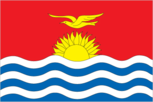
Flag description
the upper half is red with a yellow frigate bird flying over a yellow rising sun, and the lower half is blue with three horizontal wavy white stripes to represent the Pacific ocean; the white stripes represent the three island groups - the Gilbert, Line, and Phoenix Islands; the 17 rays of the sun represent the 16 Gilbert Islands and Banaba (formerly Ocean Island); the frigate bird symbolizes authority and freedom
Government type
republic
Independence
12 July 1979 (from the UK)
International law organization participation
has not submitted an ICJ jurisdiction declaration; non-party state to the ICCt
International organization participation
ACP, ADB, AOSIS, C, FAO, IBRD, ICAO, ICRM, IDA, IFAD, IFC, IFRCS, ILO, IMF, IMO, IOC, ITU, ITUC (NGOs), OPCW, PIF, Sparteca, SPC, UN, UNCTAD, UNESCO, UPU, WHO, WMO
Judicial branch
Court of Appeal; High Court; 26 Magistrates' courts; judges at all levels are appointed by the president
Legal system
English common law supplemented by customary law
Legislative branch
- unicameral House of Parliament or Maneaba Ni Maungatabu (46 seats; 44 members elected by popular vote, 1 ex officio member - the attorney general, 1 nominated by the Rabi Council of Leaders (representing Banaba Island); members serve four-year terms) legislative elections were held in two rounds - the first round on 21 October 2011 and the second round on 28 October 2011 (next to be held in 2015) percent of vote by party - NA; seats by party - NA, other 2 (includes attorney general)
- election results
- percent of vote by party - NA; seats by party - NA, other 2 (includes attorney general)
- elections
- legislative elections were held in two rounds - the first round on 21 October 2011 and the second round on 28 October 2011 (next to be held in 2015)
National anthem
- "Teirake kaini Kiribati" (Stand Up, Kiribati) Urium Tamuera IOTEBA adopted 1979
- lyrics/music
- Urium Tamuera IOTEBA
- name
- "Teirake kaini Kiribati" (Stand Up, Kiribati)
National holiday
Independence Day, 12 July (1979)
National symbol(s)
frigatebird
Political parties and leaders
Boutokaan Te Koaua Party or BTK [Anote TONG]; Kamaeuraoan Te I-Kiribati Party or KTK [Tetaua TAITAI]; Maurin Kiribati Pati or MKP [Rimeta BENIAMINA] there is no tradition of formally organized political parties in Kiribati; they more closely resemble factions or interest groups because they have no party headquarters, formal platforms, or party structures
Political pressure groups and leaders
NA
Suffrage
18 years of age; universal
Economy
Agriculture - products
copra, taro, breadfruit, sweet potatoes, vegetables; fish
Budget
- $55.52 million $107.1 million (2010 est.)
- expenditures
- $107.1 million (2010 est.)
- revenues
- $55.52 million
Budget surplus (+) or deficit (-)
-29.6% of GDP (2010 est.)
Current account balance
-$21 million (2007 est.) -$35.01 million (2010 est.)
Debt - external
$10 million (1999 est.)
Economy - overview
A remote country of 33 scattered coral atolls, Kiribati has few natural resources and is one of the least developed Pacific Islands. Commercially viable phosphate deposits were exhausted at the time of independence from the UK in 1979. Copra and fish now represent the bulk of production and exports. The economy has fluctuated widely in recent years. Economic development is constrained by a shortage of skilled workers, weak infrastructure, and remoteness from international markets. Tourism provides more than one-fifth of GDP. Private sector initiatives and a financial sector are in the early stages of development. Foreign financial aid from the EU, UK, US, Japan, Australia, New Zealand, Canada, UN agencies, and Taiwan accounts for 20-25% of GDP. Remittances from seamen on merchant ships abroad account for more than $5 million each year. Kiribati receives around $15 million annually for the government budget from an Australian trust fund.
Exchange rates
Australian dollars (AUD) per US dollar - 0.963 (2011) 1.0902 (2010) 1.0902 (2010) 1.2822 (2009) 1.2059 (2008)
Exports
$7.066 million (2010 est.) $17 million (2004 est.)
Exports - commodities
copra 62%, coconuts, seaweed, fish
Fiscal year
NA
GDP - composition by sector
- 24.3% 7.9% 67.8% (2010 est.)
- agriculture
- 24.3%
- industry
- 7.9%
- services
- 67.8% (2010 est.)
GDP - per capita (PPP)
$5,900 (2012 est.) $5,800 (2011 est.) $5,800 (2010 est.) data are in 2012 US dollars
GDP - real growth rate
2.5% (2012 est.) 1.8% (2011 est.) 1.4% (2010 est.)
GDP (official exchange rate)
$174 million (2012 est.)
GDP (purchasing power parity)
$624 million (2012 est.) $608.7 million (2011 est.) $597.8 million (2010 est.) data are in 2012 US dollars
Household income or consumption by percentage share
- NA% NA%
- highest 10%
- NA%
- lowest 10%
- NA%
Imports
$80.09 million (2010 est.) $62 million (2004 est.)
Imports - commodities
foodstuffs, machinery and equipment, miscellaneous manufactured goods, fuel
Industrial production growth rate
NA%
Inflation rate (consumer prices)
0.2% (2007 est.)
Labor force
7,870 economically active, not including subsistence farmers (2001)
Labor force - by occupation
- 2.7% 32% 65.3% (2000)
- agriculture
- 2.7%
- industry
- 32%
- services
- 65.3% (2000)
Market value of publicly traded shares
$NA
Population below poverty line
NA%
Reserves of foreign exchange and gold
$8.37 million (2010 est.)
Taxes and other revenues
31.9% of GDP (2010 est.)
Unemployment rate
2% (1992 est.)
Energy
Carbon dioxide emissions from consumption of energy
43,690 Mt (2010 est.)
Crude oil - exports
0 bbl/day (2009 est.)
Crude oil - imports
0 bbl/day (2009 est.)
Crude oil - production
0 bbl/day (2011 est.)
Crude oil - proved reserves
0 bbl (1 January 2012 est.)
Electricity - consumption
19.53 million kWh (2009 est.)
Electricity - exports
0 kWh (2010 est.)
Electricity - from fossil fuels
100% of total installed capacity (2009 est.)
Electricity - from hydroelectric plants
0% of total installed capacity (2009 est.)
Electricity - from nuclear fuels
0% of total installed capacity (2009 est.)
Electricity - from other renewable sources
0% of total installed capacity (2009 est.)
Electricity - imports
0 kWh (2010 est.)
Electricity - installed generating capacity
6,000 kW (2009 est.)
Electricity - production
21 million kWh (2009 est.)
Natural gas - consumption
0 cu m (2010 est.)
Natural gas - exports
0 cu m (2010 est.)
Natural gas - imports
0 cu m (2010 est.)
Natural gas - production
0 cu m (2010 est.)
Natural gas - proved reserves
0 cu m (1 January 2012 est.)
Refined petroleum products - consumption
300 bbl/day (2011 est.)
Refined petroleum products - exports
0 bbl/day (2008 est.)
Refined petroleum products - imports
260.8 bbl/day (2008 est.)
Refined petroleum products - production
0 bbl/day (2008 est.)
Communications
Broadcast media
1 TV broadcast station that provides about 1 hour of local programming Monday-Friday; multi-channel TV packages provide access to Australian and US stations; 1 government-operated radio station broadcasting on AM, FM, and shortwave (2009)
Internet country code
.ki
Internet hosts
327 (2012)
Internet users
7,800 (2009)
Telephone system
- generally good quality national and international service wire line service available on Tarawa and Kiritimati (Christmas Island); connections to outer islands by HF/VHF radiotelephone; wireless service available in Tarawa since 1999 country code - 686; Kiribati is being linked to the Pacific Ocean Cooperative Telecommunications Network, which should improve telephone service; satellite earth station - 1 Intelsat (Pacific Ocean)
- domestic
- wire line service available on Tarawa and Kiritimati (Christmas Island); connections to outer islands by HF/VHF radiotelephone; wireless service available in Tarawa since 1999
- general assessment
- generally good quality national and international service
- international
- country code - 686; Kiribati is being linked to the Pacific Ocean Cooperative Telecommunications Network, which should improve telephone service; satellite earth station - 1 Intelsat (Pacific Ocean)
Telephones - main lines in use
8,500 (2011)
Telephones - mobile cellular
13,800 (2011)
Transportation
Airports
19 (2012)
Airports - with paved runways
- 4 (2012)
- 1,524 to 2,437 m
- 4 (2012)
- total
- 4
Airports - with unpaved runways
- 5 (2012)
- 914 to 1,523 m
- 10
- total
- 15
- under 914 m
- 5 (2012)
Merchant marine
- bulk carrier 7, cargo 35, chemical tanker 6, passenger 1, passenger/cargo 1, petroleum tanker 12, refrigerated cargo 15 43 (China 26, Hong Kong 2, Russia 1, Singapore 9, South Korea 1, Taiwan 2, Vietnam 2) (2010)
- foreign-owned
- 43 (China 26, Hong Kong 2, Russia 1, Singapore 9, South Korea 1, Taiwan 2, Vietnam 2) (2010)
- total
- 77
Ports and terminals
Betio (Tarawa Atoll), Canton Island, English Harbor
Roadways
- 670 km (2000)
- total
- 670 km (2000)
Waterways
5 km (small network of canals in Line Islands) (2012)
Military and Security
Manpower available for military service
- 25,190 (2010 est.)
- males age 16-49
- 25,190 (2010 est.)
Manpower fit for military service
- 18,364 20,302 (2010 est.)
- females age 16-49
- 20,302 (2010 est.)
- males age 16-49
- 18,364
Manpower reaching militarily significant age annually
- 1,132 1,120 (2010 est.)
- female
- 1,120 (2010 est.)
- male
- 1,132
Military - note
Kiribati does not have military forces; defense assistance is provided by Australia and NZ
Military branches
no regular military forces (establishment prevented by the constitution); Police Force (2011)
Military expenditures
NA
Transnational Issues
Disputes - international
none