1996 Edition
CIA World Factbook 1996 (Project Gutenberg)
Introduction
Description
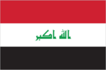
three equal horizontal bands of red (top), white, and black with three green five-pointed stars in a horizontal line centered in the white band; the phrase ALLAHU AKBAR (God is Great) in green Arabic script - Allahu to the right of the middle star and Akbar to the left of the middle star - was added in January 1991 during the Persian Gulf crisis; similar to the flag of Syria that has two stars but no script and the flag of Yemen that has a plain white band; also similar to the flag of Egypt that has a symbolic eagle centered in the white band
Location
33 00 N, 44 00 E -- Middle East, bordering the Persian Gulf, between Iran and Kuwait Flag ----
Geography
Area
- comparative area
- slightly more than twice the size of Idaho
- land area
- 432,162 sq km
- total area
- 437,072 sq km
Climate
mostly desert; mild to cool winters with dry, hot, cloudless summers; northern mountainous regions along Iranian and Turkish borders experience cold winters with occasionally heavy snows which melt in early spring, sometimes causing extensive flooding in central and southern Iraq
Coastline
58 km
Environment
- current issues
- government water control projects have drained most of the inhabited marsh areas east of An Nasiriyah by drying up or diverting the feeder streams and rivers; a once sizable population of Shi'a Muslims, who have inhabited these areas for thousands of years, has been displaced; furthermore, the destruction of the natural habitat poses serious threats to the area's wildlife populations; inadequate supplies of potable water; development of Tigris-Euphrates Rivers system contingent upon agreements with upstream riparian Turkey; air and water pollution; soil degradation (salinization) and erosion; desertification
- international agreements
- party to - Law of the Sea, Nuclear Test Ban; signed, but not ratified - Environmental Modification
- natural hazards
- dust storms, sandstorms, floods
Geographic coordinates
33 00 N, 44 00 E
International disputes
Iran and Iraq restored diplomatic relations in 1990 but are still trying to work out written agreements settling outstanding disputes from their eight-year war concerning border demarcation, prisoners-of-war, and freedom of navigation and sovereignty over the Shatt al Arab waterway; in November 1994, Iraq formally accepted the UN-demarcated border with Kuwait which had been spelled out in Security Council Resolutions 687 (1991), 773 (1993), and 883 (1993); this formally ends earlier claims to Kuwait and to Bubiyan and Warbah islands; dispute over water development plans by Turkey for the Tigris and Euphrates Rivers
Irrigated land
25,500 sq km (1989 est.)
Land boundaries
- border countries
- Iran 1,458 km, Jordan 181 km, Kuwait 242 km, Saudi Arabia 814 km, Syria 605 km, Turkey 331 km
- total
- 3,631 km
Land use
- arable land
- 12%
- forest and woodland
- 3%
- meadows and pastures
- 9%
- other
- 75%
- permanent crops
- 1%
Location
Middle East, bordering the Persian Gulf, between Iran and Kuwait
Map references
Middle East
Maritime claims
- continental shelf
- not specified
- territorial sea
- 12 nm
Natural resources
petroleum, natural gas, phosphates, sulfur
Terrain
- mostly broad plains; reedy marshes along Iranian border in south; mountains along borders with Iran and Turkey
- highest point
- Gundah Zhur 3,608 m
- lowest point
- Persian Gulf 0 m
People and Society
Age structure
0-14 years: 48% (male 5,179,240; female 5,014,141) 15-64 years: 49% (male 5,342,529; female 5,228,802) 65 years and over: 3% (male 307,097; female 350,483) (July 1996 est.)
Birth rate
43.07 births/1,000 population (1996 est.)
Death rate
6.57 deaths/1,000 population (1996 est.)
Ethnic divisions
Arab 75%-80%, Kurdish 15%-20%, Turkoman, Assyrian or other 5%
Infant mortality rate
60 deaths/1,000 live births (1996 est.)
Languages
Arabic, Kurdish (official in Kurdish regions), Assyrian, Armenian
Life expectancy at birth
- female
- 68.03 years (1996 est.)
- male
- 65.92 years
- total population
- 66.95 years
Literacy
- age 15 and over can read and write (1995 est.)
- female
- 45%
- male
- 70.7%
- total population
- 58%
Nationality
- adjective
- Iraqi
- noun
- Iraqi(s)
Net migration rate
0.37 migrant(s)/1,000 population (1996 est.)
Population
21,422,292 (July 1996 est.)
Population growth rate
3.69% (1996 est.)
Religions
Muslim 97% (Shi'a 60%-65%, Sunni 32%-37%), Christian or other 3%
Sex ratio
- all ages
- 1.02 male(s)/female (1996 est.)
- at birth
- 1.05 male(s)/female
- under 15 years
- 1.03 male(s)/female 15-64 years: 1.02 male(s)/female 65 years and over: 0.88 male(s)/female
Total fertility rate
6.41 children born/woman (1996 est.)
Government
Administrative divisions
18 provinces (muhafazat, singular - muhafazah); Al Anbar, Al Basrah, Al Muthanna, Al Qadisiyah, An Najaf, Arbil, As Sulaymaniyah, At Ta'mim, Babil, Baghdad, Dahuk, Dhi Qar, Diyala, Karbala', Maysan, Ninawa, Salah ad Din, Wasit
Capital
Baghdad
Constitution
22 September 1968, effective 16 July 1970 (provisional Constitution); new constitution drafted in 1990 but not adopted
Data code
IZ
Diplomatic representation in US
none; note - Iraq has an Interest Section in the Algerian Embassy; address: Iraqi Interests Section, Algerian Embassy, 1801 P Street NW, Washington, DC 20036; telephone: [1] (202) 483-7500; FAX: [1] (202) 462-5066
Executive branch
- chief of state
- President SADDAM Husayn (since 16 July 1979); Vice President Taha Muhyi al-Din MARUF (since 21 April 1974); Vice President Taha Yasin RAMADAN (since 23 March 1991) were elected by a two-thirds majority of the Revolutionary Command Council
- head of government
- Prime Minister SADDAM Husayn (since NA May 1994); Deputy Prime Minister Tariq Mikhail AZIZ (since NA 1979)
Flag
three equal horizontal bands of red (top), white, and black with three green five-pointed stars in a horizontal line centered in the white band; the phrase ALLAHU AKBAR (God is Great) in green Arabic script - Allahu to the right of the middle star and Akbar to the left of the middle star - was added in January 1991 during the Persian Gulf crisis; similar to the flag of Syria that has two stars but no script and the flag of Yemen that has a plain white band; also similar to the flag of Egypt that has a symbolic eagle centered in the white band
Independence
3 October 1932 (from League of Nations mandate under British administration)
International organization participation
ABEDA, ACC, AFESD, AL, AMF, CAEU, CCC, ESCWA, FAO, G-19, G-77, IAEA, IBRD, ICAO, ICRM, IDA, IDB, IFAD, IFC, IFRCS, ILO, IMF, IMO, Inmarsat, Intelsat, Interpol, IOC, ITU, NAM, OAPEC, OIC, OPEC, PCA, UN, UNCTAD, UNESCO, UNIDO, UPU, WFTU, WHO, WIPO, WMO, WToO
Judicial branch
Court of Cassation
Legal system
based on Islamic law in special religious courts, civil law system elsewhere; has not accepted compulsory ICJ jurisdiction
Legislative branch
unicameral
Name of country
- conventional long form
- Republic of Iraq
- conventional short form
- Iraq
- local long form
- Al Jumhuriyah al Iraqiyah
- local short form
- Al Iraq
National Assembly (Majlis al-Watani)
- elections last held 24 March 1996 (next to be held NA); results - percent of vote NA; seats - (250 total, 30 appointed by SADDAM Husayn to represent three northern provonces of Dahuk, Arbil, and As Sulaymaniyah)
- note
- in northern Iraq, a "Kurdish Assembly" was elected in May 1992 and calls for Kurdish self-determination within a federated Iraq; the assembly is not recognized by the Baghdad government
National holiday
Anniversary of the Revolution, 17 July (1968)
Other political or pressure groups
political parties and activity severely restricted; opposition to regime from disaffected members of the Ba'th Party, Army officers, tribes, and Shi'a religious and ethnic Kurdish dissidents; the Green Party (government-controlled)
Political parties and leaders
Ba'th Party, SADDAM Husayn, central party leader
Revolutionary Command Council
- Chairman SADDAM Husayn, Vice Chairman Izzat IBRAHIM al-Duri
- cabinet
- Council of Ministers
Suffrage
18 years of age; universal
Type of government
republic
US diplomatic representation
none; note - the US has an Interests Section in the Polish Embassy in Baghdad, which is in the Masbah Quarter (opposite the Foreign Ministry Club); address: P. O. Box 2447 Alwiyah, Baghdad; telephone: [964] (1) 719-6138, 719-6139, 718-1840, 719-3791; Telex 212287
Economy
Agriculture
wheat, barley, rice, vegetables, dates, other fruit, cotton; cattle, sheep
Budget
- expenditures
- $NA, including capital expenditures of $NA
- revenues
- $NA
Currency
1 Iraqi dinar (ID) = 1,000 fils
Economic aid
- recipient
- ODA, $NA
Economic overview
The Ba'thist regime engages in extensive central planning and management of industrial production and foreign trade while leaving some small-scale industry and services and most agriculture to private enterprise. The economy has been dominated by the oil sector, which has traditionally provided about 95% of foreign exchange earnings. In the 1980s, financial problems caused by massive expenditures in the eight-year war with Iran and damage to oil export facilities by Iran, led the government to implement austerity measures and to borrow heavily and later reschedule foreign debt payments; Iraq suffered economic losses of at least $100 billion from the war. After the end of hostilities in 1988, oil exports gradually increased with the construction of new pipelines and restoration of damaged facilities. Agricultural development remained hampered by labor shortages, salinization, and dislocations caused by previous land reform and collectivization programs. The industrial sector, although accorded high priority by the government, also was under financial constraints. Iraq's seizure of Kuwait in August 1990, subsequent international economic embargoes, and military action by an international coalition beginning in January 1991 drastically changed the economic picture. Industrial and transportation facilities, which suffered severe damage, have been partially restored. Oil exports remain at less than 5% of the previous level. Shortages of spare parts continue. Living standards deteriorated even further in 1994 and 1995; consumer prices have more than doubled in both 1994 and 1995. The UN-sponsored economic embargo has reduced exports and imports and has contributed to the sharp rise in prices. The Iraqi Government has been unwilling to abide by UN resolutions so that the economic embargo can be removed. The government's policies of supporting large military and internal security forces and of allocating resources to key supporters of the regime have exacerbated shortages. In brief, per capita output for 1994-95 is well below the 1989-90 level, but any estimate has a wide range of error.
Electricity
- capacity
- 7,170,000 kW
- consumption per capita
- 1,247 kWh (1993)
- production
- 25.7 billion kWh
Exchange rates
Iraqi dinars (ID) per US$1 - 3.2169 (fixed official rate since 1982); black-market rate (December 1995) US$1 = 2,900 Iraqi dinars; semi-official rate US$1 = 1,000 Iraqi dinars
Exports
- $NA
- commodities
- crude oil and refined products, fertilizer, sulfur
- partners
- US, Brazil, Turkey, Japan, Netherlands, Spain (1990)
External debt
$50 billion (1989 est.), excluding debt of about $35 billion owed to Gulf Arab states
Fiscal year
calendar year
GDP
purchasing power parity - $41.1 billion (1995 est.)
GDP composition by sector
- agriculture
- NA%
- industry
- NA%
- services
- NA%
GDP per capita
$2,000 (1995 est.)
GDP real growth rate
NA%
Imports
- $NA
- commodities
- manufactures, food
- partners
- Germany, US, Turkey, France, UK (1990)
Industrial production growth rate
NA%
Industries
petroleum, chemicals, textiles, construction materials, food processing
Inflation rate (consumer prices)
NA%
Labor force
- 4.4 million (1989)
- by occupation
- services 48%, agriculture 30%, industry 22%
- note
- severe labor shortage; expatriate labor force was about 1,600,000 (July 1990); since then, it has declined substantially
Unemployment rate
NA%
Communications
Branches
Army, Republican Guard and Special Republican Guard, Navy, Air Force, Air Defense Force, Border Guard Force, Internal Security Forces
Defense expenditures
$NA, NA% of GDP
Manpower availability
- males age 15-49
- 4,832,001
- males fit for military service
- 2,711,312
- males reach military age (18) annually
- 237,843 (1996 est.)
Radio broadcast stations
AM 16, FM 1, shortwave 0
Radios
4.02 million (1991 est.)
Telephone system
- reconstitution of damaged telecommunication facilities began after the Gulf war; most damaged facilities have been rebuilt
- domestic
- the network consists of coaxial cables and microwave radio relay links
- international
- satellite earth stations - 2 Intelsat (1 Atlantic Ocean and 1 Indian Ocean), 1 Intersputnik (Atlantic Ocean Region) and 1 Arabsat; coaxial cable and microwave radio relay to Jordan, Kuwait, Syria, and Turkey; Kuwait line is probably nonoperational
Telephones
632,000 (1987 est.)
Television broadcast stations
13
Televisions
1 million (1992 est.) Defense
Transportation
Airports
- total
- 102
- with paved runways 1 524 to 2 437 m
- 8
- with paved runways 2 438 to 3 047 m
- 34
- with paved runways 914 to 1 523 m
- 6
- with paved runways over 3 047 m
- 21
- with paved runways under 914 m
- 16
- with unpaved runways 1 524 to 2 437 m
- 3
- with unpaved runways 2 438 to 3 047 m
- 3
- with unpaved runways 914 to 1 523 m
- 9 (1995 est.)
- with unpaved runways over 3 047 m
- 2
Heliports
5 (1995 est.)
Highways
- paved
- 38,402 km (including 976 km of expressways)
- total
- 45,554 km
- unpaved
- 7,152 km (1989 est.)
Merchant marine
- ships by type
- cargo 14, oil tanker 16, passenger 1, passenger-cargo 1, refrigerated cargo 1, roll-on/roll-off cargo 3 (1995 est.)
- total
- 36 ships (1,000 GRT or over) totaling 795,346 GRT/1,432,292 DWT
Pipelines
crude oil 4,350 km; petroleum products 725 km; natural gas 1,360 km
Ports
Umm Qasr, Khawr az Zubayr, and Al Basrah have limited functionality
Railways
- standard gauge
- 2,032 km 1.435-m gauge
- total
- 2,032 km
Waterways
1,015 km; Shatt al Arab is usually navigable by maritime traffic for about 130 km; channel has been dredged to 3 meters and is in use; Tigris and Euphrates Rivers have navigable sections for shallow-draft watercraft; Shatt al Basrah canal was navigable by shallow-draft craft before closing in 1991 because of the Persian Gulf war