2011 Edition
CIA World Factbook 2011 Archive (HTML)
Introduction
Background
The Indus Valley civilization, one of the world's oldest, flourished during the 3rd and 2nd millennia B.C. and extended into northwestern India. Aryan tribes from the northwest infiltrated onto the Indian subcontinent about 1500 B.C.; their merger with the earlier Dravidian inhabitants created the classical Indian culture. The Maurya Empire of the 4th and 3rd centuries B.C. - which reached its zenith under ASHOKA - united much of South Asia. The Golden Age ushered in by the Gupta dynasty (4th to 6th centuries A.D.) saw a flowering of Indian science, art, and culture. Islam spread across the subcontinent over a period of 700 years. In the 10th and 11th centuries, Turks and Afghans invaded India and established the Delhi Sultanate. In the early 16th century, the Emperor BABUR established the Mughal Dynasty which ruled India for more than three centuries. European explorers began establishing footholds in India during the 16th century. By the 19th century, Great Britain had become the dominant political power on the subcontinent. The British Indian Army played a vital role in both World Wars. Nonviolent resistance to British rule, led by Mohandas GANDHI and Jawaharlal NEHRU, eventually brought about independence in 1947. Communal violence led to the subcontinent's bloody partition, which resulted in the creation of two separate states, India and Pakistan. The two countries have fought three wars since independence, the last of which in 1971 resulted in East Pakistan becoming the separate nation of Bangladesh. India's nuclear weapons tests in 1998 caused Pakistan to conduct its own tests that same year. In November 2008, terrorists originating from Pakistan conducted a series of coordinated attacks in Mumbai, India's financial capital. In January 2011, India assumed a nonpermanent seat in the UN Security Council for the 2011-12 term. Despite pressing problems such as significant overpopulation, environmental degradation, extensive poverty, and widespread corruption, rapid economic development is fueling India's rise on the world stage. India's economic growth slowed last year, however, dropping from 8.5 percent in 2010 to around 7 percent.
Geography
Area
- 3,287,263 sq km 2,973,193 sq km 314,070 sq km
- total
- 3,287,263 sq km
- water
- 314,070 sq km
Area - comparative
slightly more than one-third the size of the US
Climate
varies from tropical monsoon in south to temperate in north
Coastline
7,000 km
Elevation extremes
- Indian Ocean 0 m Kanchenjunga 8,598 m
- highest point
- Kanchenjunga 8,598 m
- lowest point
- Indian Ocean 0 m
Environment - current issues
deforestation; soil erosion; overgrazing; desertification; air pollution from industrial effluents and vehicle emissions; water pollution from raw sewage and runoff of agricultural pesticides; tap water is not potable throughout the country; huge and growing population is overstraining natural resources
Environment - international agreements
- Antarctic-Environmental Protocol, Antarctic-Marine Living Resources, Antarctic Treaty, Biodiversity, Climate Change, Climate Change-Kyoto Protocol, Desertification, Endangered Species, Environmental Modification, Hazardous Wastes, Law of the Sea, Ozone Layer Protection, Ship Pollution, Tropical Timber 83, Tropical Timber 94, Wetlands, Whaling none of the selected agreements
- party to
- Antarctic-Environmental Protocol, Antarctic-Marine Living Resources, Antarctic Treaty, Biodiversity, Climate Change, Climate Change-Kyoto Protocol, Desertification, Endangered Species, Environmental Modification, Hazardous Wastes, Law of the Sea, Ozone Layer Protection, Ship Pollution, Tropical Timber 83, Tropical Timber 94, Wetlands, Whaling
- signed, but not ratified
- none of the selected agreements
Freshwater withdrawal (domestic/industrial/agricultural)
- 645.84 cu km/yr (8%/5%/86%) 585 cu m/yr (2000)
- per capita
- 585 cu m/yr (2000)
- total
- 645.84 cu km/yr (8%/5%/86%)
Geographic coordinates
20 00 N, 77 00 E
Geography - note
dominates South Asian subcontinent; near important Indian Ocean trade routes; Kanchenjunga, third tallest mountain in the world, lies on the border with Nepal
Irrigated land
622,860 sq km (2008)
Land boundaries
- 14,103 km Bangladesh 4,053 km, Bhutan 605 km, Burma 1,463 km, China 3,380 km, Nepal 1,690 km, Pakistan 2,912 km
- border countries
- Bangladesh 4,053 km, Bhutan 605 km, Burma 1,463 km, China 3,380 km, Nepal 1,690 km, Pakistan 2,912 km
- total
- 14,103 km
Land use
- 48.83% 2.8% 48.37% (2005)
- arable land
- 48.83%
- other
- 48.37% (2005)
- permanent crops
- 2.8%
Location
Southern Asia, bordering the Arabian Sea and the Bay of Bengal, between Burma and Pakistan
Map references
Asia
Maritime claims
- 12 nm 24 nm 200 nm 200 nm or to the edge of the continental margin
- contiguous zone
- 24 nm
- continental shelf
- 200 nm or to the edge of the continental margin
- exclusive economic zone
- 200 nm
- territorial sea
- 12 nm
Natural hazards
- droughts; flash floods, as well as widespread and destructive flooding from monsoonal rains; severe thunderstorms; earthquakes Barren Island (elev. 354 m) in the Andaman Sea has been active in recent years
- volcanism
- Barren Island (elev. 354 m) in the Andaman Sea has been active in recent years
Natural resources
coal (fourth-largest reserves in the world), iron ore, manganese, mica, bauxite, rare earth elements, titanium ore, chromite, natural gas, diamonds, petroleum, limestone, arable land
Terrain
upland plain (Deccan Plateau) in south, flat to rolling plain along the Ganges, deserts in west, Himalayas in north
Total renewable water resources
1,907.8 cu km (1999)
People and Society
Age structure
- 29.7% (male 187,450,635/female 165,415,758) 64.9% (male 398,757,331/female 372,719,379) 5.5% (male 30,831,190/female 33,998,613) (2011 est.)
- 0-14 years
- 29.7% (male 187,450,635/female 165,415,758)
- 15-64 years
- 64.9% (male 398,757,331/female 372,719,379)
- 65 years and over
- 5.5% (male 30,831,190/female 33,998,613) (2011 est.)
Birth rate
20.97 births/1,000 population (2011 est.)
Children under the age of 5 years underweight
43.5% (2006)
Death rate
7.48 deaths/1,000 population (July 2011 est.)
Drinking water source
- urban: 96% of population rural: 84% of population total: 88% of population urban: 4% of population rural: 16% of population total: 12% of population (2008)
- rural
- 16% of population
- total
- 12% of population (2008)
- urban
- 4% of population
Education expenditures
3.1% of GDP (2006)
Ethnic groups
Indo-Aryan 72%, Dravidian 25%, Mongoloid and other 3% (2000)
Health expenditures
2.4% of GDP (2009)
HIV/AIDS - adult prevalence rate
0.3% (2009 est.)
HIV/AIDS - deaths
170,000 (2009 est.)
HIV/AIDS - people living with HIV/AIDS
2.4 million (2009 est.)
Hospital bed density
0.9 beds/1,000 population (2005)
Infant mortality rate
- 47.57 deaths/1,000 live births 46.18 deaths/1,000 live births 49.14 deaths/1,000 live births (2011 est.)
- female
- 49.14 deaths/1,000 live births (2011 est.)
- total
- 47.57 deaths/1,000 live births
Languages
- Hindi 41%, Bengali 8.1%, Telugu 7.2%, Marathi 7%, Tamil 5.9%, Urdu 5%, Gujarati 4.5%, Kannada 3.7%, Malayalam 3.2%, Oriya 3.2%, Punjabi 2.8%, Assamese 1.3%, Maithili 1.2%, other 5.9% English enjoys the status of subsidiary official language but is the most important language for national, political, and commercial communication; Hindi is the most widely spoken language and primary tongue of 41% of the people; there are 14 other official languages: Bengali, Telugu, Marathi, Tamil, Urdu, Gujarati, Malayalam, Kannada, Oriya, Punjabi, Assamese, Kashmiri, Sindhi, and Sanskrit; Hindustani is a popular variant of Hindi/Urdu spoken widely throughout northern India but is not an official language (2001 census)
- English enjoys the status of subsidiary official language but is the most important language for national, political, and commercial communication; Hindi is the most widely spoken language and primary tongue of 41% of the people; there are 14 other offici
- Bengali, Telugu, Marathi, Tamil, Urdu, Gujarati, Malayalam, Kannada, Oriya, Punjabi, Assamese, Kashmiri, Sindhi, and Sanskrit; Hindustani is a popular variant of Hindi/Urdu spoken widely throughout northern India but is not an official language (2001 census)
Life expectancy at birth
- 66.8 years 65.77 years 67.95 years (2011 est.)
- female
- 67.95 years (2011 est.)
- total population
- 66.8 years
Literacy
- age 15 and over can read and write 61% 73.4% 47.8% (2001 census)
- definition
- age 15 and over can read and write
- female
- 47.8% (2001 census)
- male
- 73.4%
- total population
- 61%
Major cities - population
NEW DELHI (capital) 21.72 million; Mumbai 19.695 million; Kolkata 15.294 million; Chennai 7.416 million; Bangalore 7.079 million (2009)
Major infectious diseases
- high bacterial diarrhea, hepatitis A and E, and typhoid fever chikungunya, dengue fever, Japanese encephalitis, and malaria rabies leptospirosis highly pathogenic H5N1 avian influenza has been identified in this country; it poses a negligible risk with extremely rare cases possible among US citizens who have close contact with birds (2009)
- animal contact disease
- rabies
- degree of risk
- high
- food or waterborne diseases
- bacterial diarrhea, hepatitis A and E, and typhoid fever
- vectorborne diseases
- chikungunya, dengue fever, Japanese encephalitis, and malaria
- water contact disease
- leptospirosis
Maternal mortality rate
230 deaths/100,000 live births (2008)
Median age
- 26.2 years 25.6 years 26.9 years (2011 est.)
- female
- 26.9 years (2011 est.)
- male
- 25.6 years
- total
- 26.2 years
Nationality
- Indian(s) Indian
- adjective
- Indian
- noun
- Indian(s)
Net migration rate
-0.05 migrant(s)/1,000 population (2011 est.)
Physicians density
0.599 physicians/1,000 population (2005)
Population
1,189,172,906 (July 2011 est.)
Population growth rate
1.344% (2011 est.)
Religions
Hindu 80.5%, Muslim 13.4%, Christian 2.3%, Sikh 1.9%, other 1.8%, unspecified 0.1% (2001 census)
Sanitation facility access
- urban: 54% of population rural: 21% of population total: 31% of population urban: 46% of population rural: 79% of population total: 69% of population (2008)
- rural
- 79% of population
- total
- 69% of population (2008)
- urban
- 46% of population
School life expectancy (primary to tertiary education)
- 10 years 11 years 10 years (2007)
- female
- 10 years (2007)
- male
- 11 years
- total
- 10 years
Sex ratio
- 1.12 male(s)/female 1.13 male(s)/female 1.07 male(s)/female 0.91 male(s)/female 1.08 male(s)/female (2011 est.)
- 15-64 years
- 1.07 male(s)/female
- 65 years and over
- 0.91 male(s)/female
- at birth
- 1.12 male(s)/female
- total population
- 1.08 male(s)/female (2011 est.)
- under 15 years
- 1.13 male(s)/female
Total fertility rate
2.62 children born/woman (2011 est.)
Unemployment, youth ages 15-24
- 10.5% 10.4% 10.8% (2004)
- female
- 10.8% (2004)
- total
- 10.5%
Urbanization
- 30% of total population (2010) 2.4% annual rate of change (2010-15 est.)
- rate of urbanization
- 2.4% annual rate of change (2010-15 est.)
- urban population
- 30% of total population (2010)
Government
Administrative divisions
28 states and 7 union territories*; Andaman and Nicobar Islands*, Andhra Pradesh, Arunachal Pradesh, Assam, Bihar, Chandigarh*, Chhattisgarh, Dadra and Nagar Haveli*, Daman and Diu*, Delhi*, Goa, Gujarat, Haryana, Himachal Pradesh, Jammu and Kashmir, Jharkhand, Karnataka, Kerala, Lakshadweep*, Madhya Pradesh, Maharashtra, Manipur, Meghalaya, Mizoram, Nagaland, Orissa, Puducherry*, Punjab, Rajasthan, Sikkim, Tamil Nadu, Tripura, Uttar Pradesh, Uttarakhand, West Bengal
Capital
- New Delhi 28 36 N, 77 12 E UTC+5.5 (10.5 hours ahead of Washington, DC during Standard Time)
- geographic coordinates
- 28 36 N, 77 12 E
- name
- New Delhi
- time difference
- UTC+5.5 (10.5 hours ahead of Washington, DC during Standard Time)
Constitution
26 January 1950; amended many times
Country name
- Republic of India India Republic of India/Bharatiya Ganarajya India/Bharat
- conventional long form
- Republic of India
- conventional short form
- India
- local long form
- Republic of India/Bharatiya Ganarajya
- local short form
- India/Bharat
Diplomatic representation from the US
- Ambassador (vacant); Charge d'Affaires A. Peter BURLEIGH Shantipath, Chanakyapuri, New Delhi 110021 use embassy street address [91] (011) 2419-8000 [91] (11) 2419-0017 Chennai (Madras), Hyderabad; Kolkata (Calcutta), Mumbai (Bombay)
- chief of mission
- Ambassador (vacant); Charge d'Affaires A. Peter BURLEIGH
- consulate(s) general
- Chennai (Madras), Hyderabad; Kolkata (Calcutta), Mumbai (Bombay)
- embassy
- Shantipath, Chanakyapuri, New Delhi 110021
- FAX
- [91] (11) 2419-0017
- mailing address
- use embassy street address
- telephone
- [91] (011) 2419-8000
Diplomatic representation in the US
- Ambassador Nirupama RAO 2107 Massachusetts Avenue NW, Washington, DC 20008; note - Consular Wing located at 2536 Massachusetts Avenue NW, Washington, DC 20008 [1] (202) 939-7000 [1] (202) 265-4351 Chicago, Houston, New York, San Francisco
- chancery
- 2107 Massachusetts Avenue NW, Washington, DC 20008; note - Consular Wing located at 2536 Massachusetts Avenue NW, Washington, DC 20008
- chief of mission
- Ambassador Nirupama RAO
- consulate(s) general
- Chicago, Houston, New York, San Francisco
- FAX
- [1] (202) 265-4351
- telephone
- [1] (202) 939-7000
Executive branch
- President Pratibha Devisingh PATIL (since 25 July 2007); Vice President Mohammad Hamid ANSARI (since 11 August 2007) Prime Minister Manmohan SINGH (since 22 May 2004) Cabinet appointed by the president on the recommendation of the prime minister president elected by an electoral college consisting of elected members of both houses of Parliament and the legislatures of the states for a five-year term (no term limits); election last held in July 2007 (next to be held in July 2012); vice president elected by both houses of Parliament for a five-year term; election last held in August 2007 (next to be held August 2012); prime minister chosen by parliamentary members of the majority party following legislative elections; election last held April - May 2009 (next to be held no later than May 2014) Pratibha PATIL elected president; percent of vote - Pratibha PATIL 65.8%, Bhairon Singh SHEKHAWAT - 34.2%
- cabinet
- Cabinet appointed by the president on the recommendation of the prime minister
- chief of state
- President Pratibha Devisingh PATIL (since 25 July 2007); Vice President Mohammad Hamid ANSARI (since 11 August 2007)
- election results
- Pratibha PATIL elected president; percent of vote - Pratibha PATIL 65.8%, Bhairon Singh SHEKHAWAT - 34.2%
- elections
- president elected by an electoral college consisting of elected members of both houses of Parliament and the legislatures of the states for a five-year term (no term limits); election last held in July 2007 (next to be held in July 2012); vice president elected by both houses of Parliament for a five-year term; election last held in August 2007 (next to be held August 2012); prime minister chosen by parliamentary members of the majority party following legislative elections; election last held April - May 2009 (next to be held no later than May 2014)
- head of government
- Prime Minister Manmohan SINGH (since 22 May 2004)
Flag description
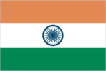
three equal horizontal bands of saffron (subdued orange) (top), white, and green, with a blue chakra (24-spoked wheel) centered in the white band; saffron represents courage, sacrifice, and the spirit of renunciation; white signifies purity and truth; green stands for faith and fertility; the blue chakra symbolizes the wheel of life in movement and death in stagnation similar to the flag of Niger, which has a small orange disk centered in the white band
Government type
federal republic
Independence
15 August 1947 (from the UK)
International law organization participation
accepts compulsory ICJ jurisdiction with reservations; non-party state to the ICCt
International organization participation
ADB, AfDB (nonregional member), ARF, ASEAN (dialogue partner), BIMSTEC, BIS, C, CD, CERN (observer), CICA, CP, EAS, FAO, FATF, G-15, G-20, G-24, G-77, IAEA, IBRD, ICAO, ICC, ICRM, IDA, IFAD, IFC, IFRCS, IHO, ILO, IMF, IMO, IMSO, Interpol, IOC, IOM, IPU, ISO, ITSO, ITU, ITUC, LAS (observer), MIGA, MONUSCO, NAM, OAS (observer), OPCW, PCA, PIF (partner), SAARC, SACEP, SCO (observer), UN, UN Security Council (temporary), UNCTAD, UNDOF, UNESCO, UNHCR, UNIDO, UNIFIL, UNISFA, UNITAR, UNMISS, UNMIT, UNOCI, UNWTO, UPU, WCO, WFTU, WHO, WIPO, WMO, WTO
Judicial branch
Supreme Court (one chief justice and 25 associate justices are appointed by the president and remain in office until they reach the age of 65 or are removed for "proved misbehavior")
Legal system
common law system based on the English model; separate personal law codes apply to Muslims, Christians, and Hindus; judicial review of legislative acts
Legislative branch
- bicameral Parliament or Sansad consists of the Council of States or Rajya Sabha (a body consisting of 245 seats up to 12 of which are appointed by the president, the remainder are chosen by the elected members of the state and territorial assemblies; members serve six-year terms) and the People's Assembly or Lok Sabha (545 seats; 543 members elected by popular vote, 2 appointed by the president; members serve five-year terms) People's Assembly - last held in five phases on 16, 22-23, 30 April and 7, 13 May 2009 (next must be held by May 2014) People's Assembly - percent of vote by party - NA; seats by party - INC 206, BJP 116, SP 23, BSP 21, JD (U) 20, AITC 19, DMK 18, CPI-M 16, BJD 14, SS 11, AIADMK 9, NCP 9, other 61, vacant 2; note - seats by party as November 2009 - INC 207, BJP 116, SP 22, BSP 21, JD (U) 20, AITC 19, DMK 18, CPI-M 16, BJD 14, SS 11, AIADMK 9, NCP 9, other 61, vacant 2
- election results
- People's Assembly - percent of vote by party - NA; seats by party - INC 206, BJP 116, SP 23, BSP 21, JD (U) 20, AITC 19, DMK 18, CPI-M 16, BJD 14, SS 11, AIADMK 9, NCP 9, other 61, vacant 2; note - seats by party as November 2009 - INC 207, BJP 116, SP 22, BSP 21, JD (U) 20, AITC 19, DMK 18, CPI-M 16, BJD 14, SS 11, AIADMK 9, NCP 9, other 61, vacant 2
- elections
- People's Assembly - last held in five phases on 16, 22-23, 30 April and 7, 13 May 2009 (next must be held by May 2014)
National anthem
- "Jana-Gana-Mana" (Thou Art the Ruler of the Minds of All People) Rabindranath TAGORE adopted 1950; Rabindranath TAGORE, a Nobel laureate, also wrote Bangladesh's national anthem
- lyrics/music
- Rabindranath TAGORE
- name
- "Jana-Gana-Mana" (Thou Art the Ruler of the Minds of All People)
National holiday
Republic Day, 26 January (1950)
National symbol(s)
Bengal tiger
Political parties and leaders
All India Anna Dravida Munnetra Kazhagam or AIADMK [J. JAYALALITHAA]; All India Trinamool Congress or AITC [Mamata BANERJEE]; Bahujan Samaj Party or BSP [MAYAWATI]; Bharatiya Janata Party or BJP [Nitin GADKARI]; Biju Janata Dal or BJD [Naveen PATNAIK]; Communist Party of India or CPI [A.B. BARDHAN]; Communist Party of India-Marxist or CPI-M [Prakash KARAT]; Dravida Munnetra Kazhagam or DMK [M.KARUNANIDHI]; Indian National Congress or INC [Sonia GANDHI]; Janata Dal (United) or JD(U) [Sharad YADAV]; Nationalist Congress Party or NCP [Sharad PAWAR]; Rashtriya Janata Dal or RJD [Lalu Prasad YADAV]; Rashtriya Lok Dal or RLD [Ajit SINGH]; Samajwadi Party or SP [Mulayam Singh YADAV]; Shiromani Akali Dal or SAD [Parkash Singh BADAL]; Shiv Sena or SS [Bal THACKERAY]; Telugu Desam Party or TDP [Chandrababu NAIDU]; note - India has dozens of national and regional political parties; only parties with four or more seats in the People's Assembly are listed
Political pressure groups and leaders
- All Parties Hurriyat Conference in the Kashmir Valley (separatist group); Bajrang Dal (religious organization); India Against Corruption [Anna HAZAREI]; Jamiat Ulema-e Hind (religious organization); Rashtriya Swayamsevak Sangh [Mohan BHAGWAT] (religious organization); Vishwa Hindu Parishad [Ashok SINGHAL] (religious organization) numerous religious or militant/chauvinistic organizations; various separatist groups seeking greater communal and/or regional autonomy; hundreds of social reform, anti-corruption, and environmental groups at state and local level
- other
- numerous religious or militant/chauvinistic organizations; various separatist groups seeking greater communal and/or regional autonomy; hundreds of social reform, anti-corruption, and environmental groups at state and local level
Suffrage
18 years of age; universal
Economy
Agriculture - products
rice, wheat, oilseed, cotton, jute, tea, sugarcane, lentils, onions, potatoes; dairy products, sheep, goats, poultry; fish
Budget
- $183.6 billion $269 billion (2010 est.)
- expenditures
- $269 billion (2010 est.)
- revenues
- $183.6 billion
Budget surplus (+) or deficit (-)
-5.6% of GDP (2010 est.)
Central bank discount rate
5.5% (31 December 2010 est.) 6% (31 December 2009 est.)
Commercial bank prime lending rate
10.167% (31 December 2010 est.) 12.2% (31 December 2009 est.)
Current account balance
-$51.78 billion (2010 est.) -$25.92 billion (2009 est.)
Debt - external
$316.9 billion (30 June 2011 est.) $251.9 billion (31 December 2010 est.)
Distribution of family income - Gini index
36.8 (2004) 37.8 (1997)
Economy - overview
India is developing into an open-market economy, yet traces of its past autarkic policies remain. Economic liberalization, including industrial deregulation, privatization of state-owned enterprises, and reduced controls on foreign trade and investment, began in the early 1990s and has served to accelerate the country's growth, which has averaged more than 7% per year since 1997. India's diverse economy encompasses traditional village farming, modern agriculture, handicrafts, a wide range of modern industries, and a multitude of services. Slightly more than half of the work force is in agriculture, but services are the major source of economic growth, accounting for more than half of India's output, with only one-third of its labor force. India has capitalized on its large educated English-speaking population to become a major exporter of information technology services and software workers. In 2010, the Indian economy rebounded robustly from the global financial crisis - in large part because of strong domestic demand - and growth exceeded 8% year-on-year in real terms. Merchandise exports, which account for about 15% of GDP, returned to pre-financial crisis levels. An industrial expansion and high food prices, resulting from the combined effects of the weak 2009 monsoon and inefficiencies in the government's food distribution system, fueled inflation which peaked at about 11% in the first half of 2010, but has gradually decreased to single digits following a series of central bank interest rate hikes. In 2010 New Delhi reduced subsidies for fuel and fertilizers, sold a small percentage of its shares in some state-owned enterprises and auctioned off rights to radio bandwidth for 3G telecommunications in part to lower the government's deficit. The Indian Government seeks to hold its budget deficit to 5.5% of GDP in FY 2010-11, down from 6.8% in the previous fiscal year. India's long term challenges include widespread poverty, inadequate physical and social infrastructure, limited non-agricultural employment opportunities, insufficient access to quality basic and higher education, and accommodating rural-to-urban migration.
Electricity - consumption
600.6 billion kWh (2008 est.)
Electricity - exports
810 million kWh (2009 est.)
Electricity - imports
5.27 billion kWh (2009 est.)
Electricity - production
835.3 billion kWh (2009 est.)
Exchange rates
Indian rupees (INR) per US dollar - 46.163 (2010) 48.405 (2009) 43.319 (2008) 41.487 (2007) 45.3 (2006)
Exports
$225.6 billion (2010 est.) $168.2 billion (2009 est.)
Exports - commodities
petroleum products, precious stones, machinery, iron and steel, chemicals, vehicles, apparel
Exports - partners
US 12.6%, UAE 12.2%, China 8.1%, Hong Kong 4.1% (2010)
GDP - composition by sector
- 19% 26.3% 54.7% (2010 est.)
- agriculture
- 19%
- industry
- 26.3%
- services
- 54.7% (2010 est.)
GDP - per capita (PPP)
$3,500 (2010 est.) $3,200 (2009 est.) $3,000 (2008 est.) data are in 2010 US dollars
GDP - real growth rate
10.4% (2010 est.) 6.8% (2009 est.) 6.2% (2008 est.)
GDP (official exchange rate)
$1.538 trillion (2010 est.)
GDP (purchasing power parity)
$4.06 trillion (2010 est.) $3.679 trillion (2009 est.) $3.447 trillion (2008 est.) data are in 2010 US dollars
Household income or consumption by percentage share
- 3.6% 31.1% (2005)
- highest 10%
- 31.1% (2005)
- lowest 10%
- 3.6%
Imports
$357.7 billion (2010 est.) $274.6 billion (2009 est.)
Imports - commodities
crude oil, precious stones, machinery, fertilizer, iron and steel, chemicals
Imports - partners
China 12.4%, UAE 6.5%, Saudi Arabia 5.8%, US 5.7%, Australia 4.5% (2010)
Industrial production growth rate
9.7% (2010 est.)
Industries
textiles, chemicals, food processing, steel, transportation equipment, cement, mining, petroleum, machinery, software, pharmaceuticals
Inflation rate (consumer prices)
12% (2010 est.) 10.9% (2009 est.)
Investment (gross fixed)
29.5% of GDP (2010 est.)
Labor force
478.3 million (2010 est.)
Labor force - by occupation
- 52% 14% 34% (2009 est.)
- agriculture
- 52%
- industry
- 14%
- services
- 34% (2009 est.)
Market value of publicly traded shares
$1.616 trillion (31 December 2010) $1.179 trillion (31 December 2009) $645.5 billion (31 December 2008)
Natural gas - consumption
64.95 billion cu m (2010 est.)
Natural gas - exports
0 cu m (2010 est.)
Natural gas - imports
12.15 billion cu m (2010 est.)
Natural gas - production
52.8 billion cu m (2010 est.)
Natural gas - proved reserves
1.074 trillion cu m (1 January 2011 est.)
Oil - consumption
3.182 million bbl/day (2010 est.)
Oil - exports
825,600 bbl/day (2009 est.)
Oil - imports
3.06 million bbl/day (2009 est.)
Oil - production
954,000 bbl/day (2010 est.)
Oil - proved reserves
5.682 billion bbl (1 January 2011 est.)
Population below poverty line
25% (2007 est.)
Public debt
50.6% of GDP (2010 est.) 53.4% of GDP (2009 est.)
Reserves of foreign exchange and gold
$287.1 billion (31 December 2010 est.) $274.7 billion (31 December 2009 est.)
Stock of broad money
$1.323 trillion (31 December 2010 est.) $1.078 trillion (31 December 2009 est.)
Stock of direct foreign investment - abroad
$91.86 billion (31 December 2010 est.) $77.21 billion (31 December 2009 est.)
Stock of direct foreign investment - at home
$188.6 billion (31 December 2010 est.) $164 billion (31 December 2009 est.)
Stock of domestic credit
$1.25 trillion (31 December 2010 est.) $973.5 billion (31 December 2009 est.)
Stock of narrow money
$340.1 billion (31 December 2010 est.) $278.3 billion (31 December 2009 est.)
Taxes and other revenues
11.9% of GDP (2010 est.)
Unemployment rate
10% (2010 est.) 9.7% (2009 est.)
Communications
Broadcast media
Doordarshan, India's public TV network, operates about 20 national, regional, and local services; large number of privately-owned TV stations are distributed by cable and satellite service providers; government controls AM radio with All India Radio operating domestic and external networks; news broadcasts via radio are limited to the All India Radio Network; since 2000, privately-owned FM stations are permitted but limited to broadcasting entertainment and educational content (2007)
Internet country code
.in
Internet hosts
4.536 million (2010)
Internet users
61.338 million (2009)
Telephone system
- supported by recent deregulation and liberalization of telecommunications laws and policies, India has emerged as one of the fastest growing telecom markets in the world; total telephone subscribership base reached 700 million, an overall teledensity of 60%, and subscribership is currently growing more than 15 million per month; urban teledensity has reached 100% and rural teledensity is about 20% and steadily growing mobile cellular service introduced in 1994 and organized nationwide into four metropolitan areas and 19 telecom circles each with multiple private service providers and one or more state-owned service providers; in recent years significant trunk capacity added in the form of fiber-optic cable and one of the world's largest domestic satellite systems, the Indian National Satellite system (INSAT), with 6 satellites supporting 33,000 very small aperture terminals (VSAT) country code - 91; a number of major international submarine cable systems, including Sea-Me-We-3 with landing sites at Cochin and Mumbai (Bombay), Sea-Me-We-4 with a landing site at Chennai, Fiber-Optic Link Around the Globe (FLAG) with a landing site at Mumbai (Bombay), South Africa - Far East (SAFE) with a landing site at Cochin, the i2i cable network linking to Singapore with landing sites at Mumbai (Bombay) and Chennai (Madras), and Tata Indicom linking Singapore and Chennai (Madras), provide a significant increase in the bandwidth available for both voice and data traffic; satellite earth stations - 8 Intelsat (Indian Ocean) and 1 Inmarsat (Indian Ocean region); 9 gateway exchanges operating from Mumbai (Bombay), New Delhi, Kolkata (Calcutta), Chennai (Madras), Jalandhar, Kanpur, Gandhinagar, Hyderabad, and Ernakulam (2010)
- domestic
- mobile cellular service introduced in 1994 and organized nationwide into four metropolitan areas and 19 telecom circles each with multiple private service providers and one or more state-owned service providers; in recent years significant trunk capacity added in the form of fiber-optic cable and one of the world's largest domestic satellite systems, the Indian National Satellite system (INSAT), with 6 satellites supporting 33,000 very small aperture terminals (VSAT)
- general assessment
- supported by recent deregulation and liberalization of telecommunications laws and policies, India has emerged as one of the fastest growing telecom markets in the world; total telephone subscribership base reached 700 million, an overall teledensity of 60%, and subscribership is currently growing more than 15 million per month; urban teledensity has reached 100% and rural teledensity is about 20% and steadily growing
- international
- country code - 91; a number of major international submarine cable systems, including Sea-Me-We-3 with landing sites at Cochin and Mumbai (Bombay), Sea-Me-We-4 with a landing site at Chennai, Fiber-Optic Link Around the Globe (FLAG) with a landing site at Mumbai (Bombay), South Africa - Far East (SAFE) with a landing site at Cochin, the i2i cable network linking to Singapore with landing sites at Mumbai (Bombay) and Chennai (Madras), and Tata Indicom linking Singapore and Chennai (Madras), provide a significant increase in the bandwidth available for both voice and data traffic; satellite earth stations - 8 Intelsat (Indian Ocean) and 1 Inmarsat (Indian Ocean region); 9 gateway exchanges operating from Mumbai (Bombay), New Delhi, Kolkata (Calcutta), Chennai (Madras), Jalandhar, Kanpur, Gandhinagar, Hyderabad, and Ernakulam (2010)
Telephones - main lines in use
35.09 million (2010)
Telephones - mobile cellular
752 million (2010)
Transportation
Airports
352 (2010)
Airports - with paved runways
- 15 (2010)
- 1,524 to 2,437 m
- 75
- 2,438 to 3,047 m
- 57
- 914 to 1,523 m
- 81
- over 3,047 m
- 21
- total
- 249
- under 914 m
- 15 (2010)
Airports - with unpaved runways
- 48 (2010)
- 1,524 to 2,437 m
- 8
- 2,438 to 3,047 m
- 3
- 914 to 1,523 m
- 43
- over 3,047 m
- 1
- total
- 103
- under 914 m
- 48 (2010)
Heliports
40 (2010)
Merchant marine
- bulk carrier 94, cargo 78, chemical tanker 23, container 15, liquefied gas 11, passenger 4, passenger/cargo 12, petroleum tanker 87 8 (China 1, Hong Kong 1, Jersey 1, Malaysia 1, UAE 4) 56 (Cyprus 2, Dominica 2, Liberia 1, Malta 4, Marshall Islands 8, Nigeria 1, Panama 17, Singapore 19, unknown 2) (2010)
- foreign-owned
- 8 (China 1, Hong Kong 1, Jersey 1, Malaysia 1, UAE 4)
- registered in other countries
- 56 (Cyprus 2, Dominica 2, Liberia 1, Malta 4, Marshall Islands 8, Nigeria 1, Panama 17, Singapore 19, unknown 2) (2010)
- total
- 324
Pipelines
condensate/gas 2 km; gas 9,596 km; liquid petroleum gas 2,152 km; oil 7,448 km; refined products 10,486 km (2010)
Ports and terminals
Chennai, Jawaharal Nehru Port, Kandla, Kolkata (Calcutta), Mumbai (Bombay), Sikka, Vishakhapatnam
Railways
- 63,974 km 54,257 km 1.676-m gauge (18,927 km electrified) 7,180 km 1.000-m gauge; 2,537 km 0.762-m gauge and 0.610-m gauge (2010)
- narrow gauge
- 7,180 km 1.000-m gauge; 2,537 km 0.762-m gauge and 0.610-m gauge (2010)
- total
- 63,974 km
Roadways
- 3,320,410 km (includes 200 km of expressways) (2009)
- total
- 3,320,410 km (includes 200 km of expressways) (2009)
Waterways
14,500 km (5,200 km on major rivers and 485 km on canals suitable for mechanized vessels) (2008)
Military and Security
Manpower available for military service
- 319,129,420 296,071,637 (2010 est.)
- females age 16-49
- 296,071,637 (2010 est.)
- males age 16-49
- 319,129,420
Manpower fit for military service
- 249,531,562 240,039,958 (2010 est.)
- females age 16-49
- 240,039,958 (2010 est.)
- males age 16-49
- 249,531,562
Manpower reaching militarily significant age annually
- 12,151,065 10,745,891 (2010 est.)
- female
- 10,745,891 (2010 est.)
- male
- 12,151,065
Military branches
Army, Navy (includes naval air arm), Air Force, Coast Guard (2011)
Military expenditures
2.5% of GDP (2006)
Military service age and obligation
17 years 6 months of age for voluntary military service; no conscription; women may join as officers, but for noncombat roles only (2010)
Transnational Issues
Disputes - international
since China and India launched a security and foreign policy dialogue in 2005, consolidated discussions related to the dispute over most of their rugged, militarized boundary, regional nuclear proliferation, Indian claims that China transferred missiles to Pakistan, and other matters continue; Kashmir remains the site of the world's largest and most militarized territorial dispute with portions under the de facto administration of China (Aksai Chin), India (Jammu and Kashmir), and Pakistan (Azad Kashmir and Northern Areas); India and Pakistan resumed bilateral dialogue in February 2011 after a two-year hiatus, have maintained the 2003 cease fire in Kashmir, and continue to have disputes over water sharing of the Indus River and its tributaries; UN Military Observer Group in India and Pakistan (UNMOGIP) has maintained a small group of peacekeepers since 1949; India does not recognize Pakistan's ceding historic Kashmir lands to China in 1964; to defuse tensions and prepare for discussions on a maritime boundary, India and Pakistan seek technical resolution of the disputed boundary in Sir Creek estuary at the mouth of the Rann of Kutch in the Arabian Sea; Pakistani maps continue to show its Junagadh claim in Indian Gujarat State; Prime Minister Singh's September 2011 visit to Bangladesh resulted in the signing of a Protocol to the 1974 Land Boundary Agreement between India and Bangladesh, which had called for the settlement of longstanding boundary disputes over undemarcated areas and the exchange of territorial enclaves, but which had never been implemented; Bangladesh referred its maritime boundary claims with Burma and India to the International Tribunal on the Law of the Sea; Joint Border Committee with Nepal continues to examine contested boundary sections, including the 400 square kilometer dispute over the source of the Kalapani River; India maintains a strict border regime to keep out Maoist insurgents and control illegal cross-border activities from Nepal
Illicit drugs
world's largest producer of licit opium for the pharmaceutical trade, but an undetermined quantity of opium is diverted to illicit international drug markets; transit point for illicit narcotics produced in neighboring countries and throughout Southwest Asia; illicit producer of methaqualone; vulnerable to narcotics money laundering through the hawala system; licit ketamine and precursor production
Refugees and internally displaced persons
- 77,200 (Tibet/China); 69,609 (Sri Lanka); 9,472 (Afghanistan) at least 600,000 (about half are Kashmiri Pandits from Jammu and Kashmir) (2007)
- IDPs
- at least 600,000 (about half are Kashmiri Pandits from Jammu and Kashmir) (2007)
- refugees (country of origin)
- 77,200 (Tibet/China); 69,609 (Sri Lanka); 9,472 (Afghanistan)