2000 Edition
CIA World Factbook 2000 (Project Gutenberg)
Introduction
Background
Nonviolent resistance to British colonialism under Mohandas GANDHI and Jawaharlal NEHRU led to independence in 1947. The subcontinent was divided into the secular state of India and the smaller Muslim state of Pakistan. A third war between the two countries in 1971 resulted in East Pakistan becoming the separate nation of Bangladesh. Fundamental concerns in India include the ongoing dispute with Pakistan over Kashmir, massive overpopulation, environmental degradation, extensive poverty, and ethnic strife, all this despite impressive gains in economic investment and output.
Geography
Area
- land
- 2,973,190 sq km
- total
- 3,287,590 sq km
- water
- 314,400 sq km
Area - comparative
slightly more than one-third the size of the US
Climate
varies from tropical monsoon in south to temperate in north
Coastline
7,000 km
Elevation extremes
- highest point
- Kanchenjunga 8,598 m
- lowest point
- Indian Ocean 0 m
Environment - current issues
deforestation; soil erosion; overgrazing; desertification; air pollution from industrial effluents and vehicle emissions; water pollution from raw sewage and runoff of agricultural pesticides; tap water is not potable throughout the country; huge and growing population is overstraining natural resources
Environment - international agreements
- party to
- Antarctic-Environmental Protocol, Antarctic Treaty, Biodiversity, Climate Change, Desertification, Endangered Species, Environmental Modification, Hazardous Wastes, Law of the Sea, Nuclear Test Ban, Ozone Layer Protection, Ship Pollution, Tropical Timber 83, Tropical Timber 94, Wetlands, Whaling signed, but not ratified: none of the selected agreements
Geographic coordinates
20 00 N, 77 00 E
Geography - note
dominates South Asian subcontinent; near important Indian Ocean trade routes
Irrigated land
480,000 sq km (1993 est.)
Land boundaries
- border countries
- Bangladesh 4,053 km, Bhutan 605 km, Burma 1,463 km, China 3,380 km, Nepal 1,690 km, Pakistan 2,912 km
- total
- 14,103 km
Land use
- arable land
- 56%
- forests and woodland
- 23%
- other
- 16% (1993 est.)
- permanent crops
- 1%
- permanent pastures
- 4%
Location
Southern Asia, bordering the Arabian Sea and the Bay of Bengal, between Burma and Pakistan
Map references
Asia
Maritime claims
- contiguous zone
- 24 nm
- continental shelf
- 200 nm or to the edge of the continental margin
- exclusive economic zone
- 200 nm
- territorial sea
- 12 nm
Natural hazards
droughts, flash floods, severe thunderstorms common; earthquakes
Natural resources
coal (fourth-largest reserves in the world), iron ore, manganese, mica, bauxite, titanium ore, chromite, natural gas, diamonds, petroleum, limestone, arable land
Terrain
upland plain (Deccan Plateau) in south, flat to rolling plain along the Ganges, deserts in west, Himalayas in north
People and Society
Age structure
0-14 years: 34% (male 175,228,164; female 165,190,951) 15-64 years: 62% (male 324,699,562; female 301,821,383) 65 years and over: 4% (male 23,925,371; female 23,138,386) (2000 est.)
Birth rate
24.79 births/1,000 population (2000 est.)
Death rate
8.88 deaths/1,000 population (2000 est.)
Ethnic groups
Indo-Aryan 72%, Dravidian 25%, Mongoloid and other 3%
Infant mortality rate
64.9 deaths/1,000 live births (2000 est.)
Languages
- English enjoys associate status but is the most important language for national, political, and commercial communication, Hindi the national language and primary tongue of 30% of the people, Bengali (official), Telugu (official), Marathi (official), Tamil (official), Urdu (official), Gujarati (official), Malayalam (official), Kannada (official), Oriya (official), Punjabi (official), Assamese (official), Kashmiri (official), Sindhi (official), Sanskrit (official), Hindustani (a popular variant of Hindi/Urdu spoken widely throughout northern India)
- note
- 24 languages each spoken by a million or more persons; numerous other languages and dialects, for the most part mutually unintelligible
Life expectancy at birth
- female
- 63.13 years (2000 est.)
- male
- 61.89 years
- total population
- 62.5 years
Literacy
- definition
- age 15 and over can read and write
- female
- 37.7% (1995 est.)
- male
- 65.5%
- total population
- 52%
Nationality
- adjective
- Indian
- noun
- Indian(s)
Net migration rate
-0.08 migrant(s)/1,000 population (2000 est.)
Population
1,014,003,817 (July 2000 est.)
Population growth rate
1.58% (2000 est.)
Religions
Hindu 80%, Muslim 14%, Christian 2.4%, Sikh 2%, Buddhist 0.7%, Jains 0.5%, other 0.4%
Sex ratio
- at birth
- 1.05 male(s)/female under 15 years: 1.06 male(s)/female 15-64 years: 1.08 male(s)/female 65 years and over: 1.03 male(s)/female
- total population
- 1.07 male(s)/female (2000 est.)
Total fertility rate
3.11 children born/woman (2000 est.)
Government
Administrative divisions
25 states and 7 union territories*; Andaman and Nicobar Islands*, Andhra Pradesh, Arunachal Pradesh, Assam, Bihar, Chandigarh*, Dadra and Nagar Haveli*, Daman and Diu*, Delhi*, Goa, Gujarat, Haryana, Himachal Pradesh, Jammu and Kashmir, Karnataka, Kerala, Lakshadweep*, Madhya Pradesh, Maharashtra, Manipur, Meghalaya, Mizoram, Nagaland, Orissa, Pondicherry*, Punjab, Rajasthan, Sikkim, Tamil Nadu, Tripura, Uttar Pradesh, West Bengal
Capital
New Delhi
Constitution
26 January 1950
Country name
- conventional long form
- Republic of India
- conventional short form
- India
Data code
IN
Diplomatic representation from the US
- chief of mission
- Ambassador Richard F. CELESTE
- embassy
- Shanti Path, Chanakyapuri 110021, New Delhi
- mailing address
- use embassy street address
- telephone
- (11) 688-9033, 611-3033
Diplomatic representation in the US
- chancery
- 2107 Massachusetts Avenue NW, Washington, DC 20008; note - Embassy located at 2536 Massachusetts Avenue NW, Washington, DC 20008
- chief of mission
- Ambassador Naresh CHANDRA
- telephone
- (202) 939-7000
Executive branch
- cabinet
- Council of Ministers appointed by the president on the recommendation of the prime minister
- chief of state
- President Kicheril Raman NARAYANAN (since 25 July 1997); Vice President Krishnan KANT (since 21 August 1997)
- election results
- Kicheril Raman NARAYANAN elected president; percent of electoral college vote - NA; Krishnan KANT elected vice president; percent of Parliament vote - NA; Atal Behari VAJPAYEE elected prime minister; percent of vote - NA
- elections
- president elected by an electoral college consisting of elected members of both houses of Parliament and the legislatures of the states for a five-year term; election last held 14 July 1997 (next to be held NA July 2002); vice president elected by both houses of Parliament for a five-year term; election last held 16 August 1997 (next to be held NA August 2002); prime minister elected by parliamentary members of the majority party following legislative elections; election last held NA October 1999 (next to be held NA October 2004)
- head of government
- Prime Minister Atal Behari VAJPAYEE (since 19 March 1998)
FAX
- (202) 483-3972
- (11) 419-0017
- consulate(s) general
- Chicago, Houston, New York, and San Francisco
- consulate(s) general
- Calcutta, Chennai (Madras), Mumbai (Bombay)
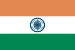
Flag description
three equal horizontal bands of orange (top), white, and green with a blue chakra (24-spoked wheel) centered in the white band; similar to the flag of Niger, which has a small orange disk centered in the white band
Government type
federal republic
Independence
15 August 1947 (from UK)
International organization participation
AfDB, AsDB, BIS, C, CCC, CP, ESCAP, FAO, G- 6, G-15, G-19, G-24, G-77, IAEA, IBRD, ICAO, ICC, ICFTU, ICRM, IDA, IEA (observer), IFAD, IFC, IFRCS, IHO, ILO, IMF, IMO, Inmarsat, Intelsat, Interpol, IOC, IOM (observer), ISO, ITU, MINURSO, MIPONUH, MONUC, NAM, OAS (observer), OPCW, PCA, SAARC, UN, UNAMSIL, UNCTAD, UNESCO, UNHCR, UNIDO, UNIFIL, UNIKOM, UNMIBH, UNMIK, UNU, UPU, WFTU, WHO, WIPO, WMO, WToO, WTrO
Judicial branch
Supreme Court, judges are appointed by the president and remain in office until they reach the age of 65
Legal system
based on English common law; limited judicial review of legislative acts; accepts compulsory ICJ jurisdiction, with reservations
Legislative branch
- bicameral Parliament or Sansad consists of the Council of States or Rajya Sabha (a body consisting of not more than 250 members, up to 12 of which are appointed by the president, the remainder are chosen by the elected members of the state and territorial assemblies; members serve six-year terms) and the People's Assembly or Lok Sabha (545 seats; 543 elected by popular vote, 2 appointed by the president; members serve five-year terms)
- election results
- People's Assembly - percent of vote by party - BJP alliance 40.8%, Congress alliance 33.8%, other 25.4%; seats by party - BJP alliance 304, Congress alliance 134, other 105
- elections
- People's Assembly - last held 5 September through 3 October 1999 (next to be held NA 2004)
National holiday
Anniversary of the Proclamation of the Republic, 26 January (1950)
Political parties and leaders
Akali Dal (representing Sikh religious community in Punjab) ; All India Anna Dravida Munnetra Kazhagam or AIADMK ; All India Forward Bloc or AIFB [Prem Dutta PALIWAL (chairman), Chitta BASU (general secretary)]; Asom Gana Parishad ; Bahujan Samaj Party or BSP ; Bharatiya Janata Party or BJP ; Bihar Peoples Party ; Biju Janata Dal or BJD [Navin PATNAIK]; Communist Party of India or CPI ; Communist Party of India/Marxist or CPI/M ; Communist Party of India/Marxist-Leninist or CPI/ML ; Congress (I) Party ; Dravida Munnetra Kazagham or DMK (a regional party in Tamil Nadu) ; Indian National League ; Janata Dal (Ajit) ; Janata Dal United Party or JDU ; Kerala Congress (Mani faction) ; Muslim League ; National Conference or NC (a regional party in Jammu and Kashmir) [Farooq ABDULLAH]; Rashtriya Janata Dal or RJD ; Revolutionary Socialist Party or RSP ; Samajwadi Party or SP ; Samata Party or SAP (formerly Janata Dal members) ; Shiv Sena or SHS ; Tamil Maanila Congress ; Telugu Desam (a regional party in Andhra Pradesh) ; Trinamool Congress
Political pressure groups and leaders
numerous religious or militant/chauvinistic organizations, including Vishwa Hindu Parishad, and Rashtriya Swayamsevak Sangh; various separatist groups seeking greater communal and/or regional autonomy
Suffrage
18 years of age; universal
Economy
Agriculture - products
rice, wheat, oilseed, cotton, jute, tea, sugarcane, potatoes; cattle, water buffalo, sheep, goats, poultry; fish
Budget
- expenditures
- $66.3 billion, including capital expenditures of $15.9 billion (FY98/99 est.)
- revenues
- $35.8 billion
Currency
1 Indian rupee (Re) = 100 paise
Debt - external
$98 billion (March 1999)
Economic aid - recipient
$2.9 billion (FY98/99)
Economy - overview
India's economy encompasses traditional village farming, modern agriculture, handicrafts, a wide range of modern industries, and a multitude of support services. More than a third of the population is too poor to be able to afford an adequate diet, and market surveys indicate that fewer than 5% of all households had an annual income equivalent to $2,300 or more in 1995-96. India's international payments position remained strong in 1999 with adequate foreign exchange reserves, reasonably stable exchange rates, and booming exports of software services. Lower production of some nonfoodgrain crops offset recovery in industrial production. Strong demand for India's high technology exports will bolster growth in 2000.
Electricity - consumption
416.346 billion kWh (1998)
Electricity - exports
130 million kWh (1998)
Electricity - imports
1.575 billion kWh (1998)
Electricity - production
448.6 billion kWh (FY98/99 est.)
Electricity - production by source
- fossil fuel
- 80.34%
- hydro
- 17.08%
- nuclear
- 2.38%
- other
- 0.2% (1998)
Exchange rates
Indian rupees (Rs) per US$1 - 43.552 (January 2000), 43.055 (1999), 41.259 (1998), 36.313 (1997), 35.433 (1996), 32.427 (1995)
Exports
$36.3 billion (f.o.b., 1999 est.)
Exports - commodities
textile goods, gems and jewelry, engineering goods, chemicals, leather manufactures
Exports - partners
US 21%, UK 6%, Germany 6%, Hong Kong 5%, Japan 5%, UAE 4% (1998)
Fiscal year
1 April - 31 March
GDP
purchasing power parity - $1.805 trillion (1999 est.)
GDP - composition by sector
- agriculture
- 25%
- industry
- 30%
- services
- 45% (1997)
GDP - per capita
purchasing power parity - $1,800 (1999 est.)
GDP - real growth rate
5.5% (1999 est.)
Household income or consumption by percentage share
lowest 10%: 4.1% highest 10%: 25% (1994)
Imports
$50.2 billion (f.o.b., 1999 est.)
Imports - commodities
crude oil and petroleum products, machinery, gems, fertilizer, chemicals
Imports - partners
US 10%, Belgium 7%, UK 6%, Germany 6%, Saudi Arabia 6%, Japan 6% (1998)
Industrial production growth rate
6% (1999 est.)
Industries
textiles, chemicals, food processing, steel, transportation equipment, cement, mining, petroleum, machinery
Inflation rate (consumer prices)
6.7% (1999 est.)
Labor force
NA
Labor force - by occupation
agriculture 67%, services 18%, industry 15% (1995 est.)
Population below poverty line
35% (1994 est.)
Unemployment rate
NA%
Communications
Internet Service Providers (ISPs)
3 (1999)
Radio broadcast stations
AM 153, FM 91, shortwave 68 (1998)
Radios
116 million (1997)
Telephone system
- mediocre service; local and long distance service provided throughout all regions of the country, with services primarily concentrated in the urban areas; major objective is to continue to expand and modernize long-distance network in order to keep pace with rapidly growing number of local subscriber lines; steady improvement is taking place with the recent admission of private and private-public investors, but demand for communication services is also growing rapidly
- domestic
- local service is provided by microwave radio relay and coaxial cable, with open wire and obsolete electromechanical and manual switchboard systems still in use in rural areas; starting in the 1980s, a substantial amount of digital switch gear has been introduced for local and long-distance service; long-distance traffic is carried mostly by coaxial cable and low-capacity microwave radio relay; since 1985 significant trunk capacity has been added in the form of fiber-optic cable and a domestic satellite system with 254 earth stations; mobile cellular service is provided in four metropolitan cities
- international
- satellite earth stations - 8 Intelsat (Indian Ocean) and 1 Inmarsat (Indian Ocean region); nine gateway exchanges operating from Mumbai (Bombay), New Delhi, Calcutta, Chennai (Madras), Jalandhar, Kanpur, Gaidhinagar, Hyderabad, and Ernakulam; 4 submarine cables - LOCOM linking Chennai (Madras) to Penang; Indo-UAE-Gulf cable linking Mumbai (Bombay) to Al Fujayrah, UAE; India-SEA-ME-WE-3, SEA-ME-WE-2 with landing sites at Cochin and Mumbai (Bombay); Fiber-Optic Link Around the Globe (FLAG) with landing site at Mumbai (Bombay)
Telephones - main lines in use
18.95 million (1999)
Telephones - mobile cellular
1.9 million (April 1998)
Television broadcast stations
562 (of which 82 stations have 1 kW or greater power and 480 stations have less than 1 kW of power) (1997)
Televisions
63 million (1997)
Transportation
Airports
346 (1999 est.)
Airports - with paved runways
- total
- 238 over 3,047 m: 12 2,438 to 3,047 m: 49 1,524 to 2,437 m: 84 914 to 1,523 m: 74 under 914 m: 19 (1999 est.)
Airports - with unpaved runways
- total
- 108 2,438 to 3,047 m: 2 1,524 to 2,437 m: 4 914 to 1,523 m: 47 under 914 m: 55 (1999 est.)
Heliports
16 (1999 est.)
Highways
- paved
- 1,517,077 km
- total
- 3,319,644 km
- unpaved
- 1,802,567 km (1996 est.)
Merchant marine
- ships by type
- bulk 124, cargo 69, chemical tanker 14, combination bulk 1, combination ore/oil 4, container 15, liquified gas 10, passenger/cargo 5, petroleum tanker 75, short-sea passenger 2, specialized tanker 2 (1999 est.)
- total
- 321 ships (1,000 GRT or over) totaling 6,647,268 GRT/11,074,025 DWT
Pipelines
crude oil 3,005 km; petroleum products 2,687 km; natural gas 1,700 km (1995)
Ports and harbors
Calcutta, Chennai (Madras), Cochin, Jawaharal Nehru, Kandla, Mumbai (Bombay), Vishakhapatnam
Railways
- broad gauge
- 40,620 km 1.676-m gauge
- narrow gauge
- 18,501 km 1.000-m gauge; 3,794 km 0.762-m and 0.610-m gauge (1998 est.)
- total
- 62,915 km (12,307 km electrified; 12,617 km double track)
Waterways
16,180 km; 3,631 km navigable by large vessels
Military and Security
Military branches
Army, Navy (including naval air arm), Air Force, various security or paramilitary forces (includes Border Security Force, Assam Rifles, and Rashtriya Rifles)
Military expenditures - dollar figure
$10.055 billion (FY00)
Military expenditures - percent of GDP
2.5% (FY00)
Military manpower - availability
males age 15-49: 274,679,455 (2000 est.)
Military manpower - fit for military service
males age 15-49: 161,223,332 (2000 est.)
Military manpower - military age
17 years of age
Military manpower - reaching military age annually
- males
- 10,759,607 (2000 est.)
Transnational Issues
Disputes - international
boundary with China in dispute; status of Kashmir with Pakistan; water-sharing problems with Pakistan over the Indus River (Wular Barrage); a portion of the boundary with Bangladesh is indefinite; dispute with Bangladesh over New Moore/South Talpatty Island
Illicit drugs
- world's largest producer of licit opium for the pharmaceutical trade, but an undetermined quantity of opium is diverted to illicit international drug markets; major transit country for illicit narcotics produced in neighboring countries; illicit producer of hashish and methaqualone
- INDIAN OCEAN