1993 Edition
CIA World Factbook 1993 (Project Gutenberg)
Geography
Area
- total area: NA km2 land area: NA km2 comparative area: NA
- total area: 3,287,590 km2 land area: 2,973,190 km2 comparative area: slightly more than one-third the size of the US
Climate
- tropical
- varies from tropical monsoon in south to temperate in north
Coastline
- 35.2 km
- 7,000 km
Environment
- surrounded by reefs; subject to periodic cyclones
- droughts, flash floods, severe thunderstorms common; deforestation; soil erosion; overgrazing; air and water pollution; desertification
International disputes
- claimed by Madagascar
- boundaries with Bangladesh and China; status of Kashmir with Pakistan; water-sharing problems with downstream riparians, Bangladesh over the Ganges and Pakistan over the Indus
Irrigated land
- 0 km2
- 430,390 km2 (1989)
Land boundaries
- 0 km
- total 14,103 km, Bangladesh 4,053 km, Bhutan 605 km, Burma 1,463 km, China 3,380 km, Nepal 1,690 km, Pakistan 2,912 km
Land use
- arable land: 0% permanent crops: 0% meadows and pastures: 0% forest and woodland: 0% other: 100% (all rock)
- arable land: 55% permanent crops: 1% meadows and pastures: 4% forest and woodland: 23% other: 17%
Location
- Southern Africa, in the southern Mozambique Channel about halfway between Madagascar and Mozambique
- South Asia, bordering the Arabian Sea and the Bay of Bengal, between Bangladesh and Pakistan
Map references
- Africa
- Asia, Standard Time Zones of the World
Maritime claims
- contiguous zone: 24 nm continental shelf: 200 m (depth) or to depth of exploitation exclusive economic zone: 200 nm territorial sea: 12 nm
- contiguous zone: 24 nm continental shelf: 200 nm or the edge of continental margin exclusive economic zone: 200 nm territorial sea: 12 nm
Natural resources
- none
- coal (fourth-largest reserves in the world), iron ore, manganese, mica, bauxite, titanium ore, chromite, natural gas, diamonds, petroleum, limestone
Note
- navigational hazard since it is usually under water during high tide
- dominates South Asian subcontinent; near important Indian Ocean trade routes
Terrain
- a volcanic rock 2.4 meters high
- upland plain (Deccan Plateau) in south, flat to rolling plain along the Ganges, deserts in west, Himalayas in north
People and Society
Birth rate
29.11 births/1,000 population (1993 est.)
Death rate
10.52 deaths/1,000 population (1993 est.)
Ethnic divisions
Indo-Aryan 72%, Dravidian 25%, Mongoloid and other 3%
Infant mortality rate
80.5 deaths/1,000 live births (1993 est.)
Labor force
284.4 million by occupation: agriculture 67% (FY85)
Languages
English enjoys associate status but is the most important language for national, political, and commercial communication, Hindi the national language and primary tongue of 30% of the people, Bengali (official), Telugu (official), Marathi (official), Tamil (official), Urdu (official), Gujarati (official), Malayalam (official), Kannada (official), Oriya (official), Punjabi (official), Assamese (official), Kashmiri (official), Sindhi (official), Sanskrit (official), Hindustani a popular variant of Hindu/Urdu, is spoken widely throughout northern India note: 24 languages each spoken by a million or more persons; numerous other languages and dialects, for the most part mutually unintelligible
Life expectancy at birth
total population: 58.12 years male: 57.69 years female: 58.59 years (1993 est.)
Literacy
age 15 and over can read and write (1990) total population: 48% male: 62% female: 34%
Nationality
noun: Indian(s) adjective: Indian
Net migration rate
0 migrant(s)/1,000 population (1993 est.)
Population
- uninhabited
- 903,158,968 (July 1993 est.)
Population growth rate
1.86% (1993 est.)
Religions
Hindu 82.6%, Muslim 11.4%, Christian 2.4%, Sikh 2%, Buddhist 0.7%, Jains 0.5%, other 0.4%
Total fertility rate
3.57 children born/woman (1993 est.)
Government
Administrative divisions
25 states and 7 union territories*; Andaman and Nicobar Islands*, Andhra, Pradesh, Arunachal Pradesh, Assam, Bihar, Chandigarh*, Dadra and Nagar, Haveli*, Daman and Diu*, Delhi*, Goa,, Gujarat, Haryana, Himachal Pradesh, Jammu and Kashmir, Karnataka, Kerala, Lakshadweep*, Madhya Pradesh,, Maharashtra, Manipur, Meghalaya, Mizoram, Nagaland, Orissa, Pondicherry*,, Punjab, Rajasthan, Sikkim, Tamil Nadu, Tripura, Uttar Pradesh, West Bengal
Capital
- none; administered by France from Reunion
- New Delhi
Chief of State
President Shankar Dayal SHARMA (since 25 July 1992); Vice President K.R. NARAYANAN (since 21 August 1992)
Constitution
26 January 1950
Digraph
- BS
- IN
Diplomatic representation in US
chief of mission: Ambassador Siddhartha Shankar RAY chancery: 2107 Massachusetts Avenue NW, Washington, DC 20008 telephone: (202) 939-7000 consulates general: Chicago, New York, and San Francisco
Executive branch
president, vice president, prime minister, Council of Ministers
FAX
[91] (11) 687-2028, 687-2391 consulates general: Bombay, Calcutta, Madras
Flag
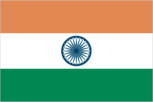
three equal horizontal bands of orange (top), white, and green with a blue chakra (24-spoked wheel) centered in the white band; similar to the flag of Niger, which has a small orange disk centered in the white band
Head of Government
Prime Minister P. V. Narasimha RAO (since 21 June 1991)
Independence
- none (possession of France)
- 15 August 1947 (from UK)
Judicial branch
Supreme Court
Legal system
based on English common law; limited judicial review of legislative acts; accepts compulsory ICJ jurisdiction, with reservations
Legislative branch
bicameral Parliament (Sansad) consists of an upper house or Council of States (Rajya Sabha) and a lower house or People's Assembly (Lok Sabha)
Member of
AG (observer), AsDB, C, CCC, CP, ESCAP, FAO, G-6, G-15, G-19, AfDB, G-24, G-77, GATT, IAEA, IBRD, ICAO, ICC, ICFTU, IDA, IFAD, IFC, ILO, IMF, IMO, INMARSAT, INTELSAT, INTERPOL, IOC, IOM (observer), ISO, ITU, LORCS, NAM, ONUSAL, PCA, SAARC, UN, UNAVEM II, UNCTAD, UNESCO, UNIDO, UNIKOM, UNOMOZ, UNTAC, UPU, WFTU, WHO, WIPO, WMO, WTO
Names
- conventional long form: none conventional short form: Bassas da India
- conventional long form: Republic of India conventional short form: India
National holiday
Anniversary of the Proclamation of the Republic, 26 January (1950)
Other political or pressure groups
various separatist groups seeking greater communal and/or regional autonomy; numerous religious or militant/chauvinistic organizations, including Adam Sena, Ananda Marg, Vishwa Hindu Parishad, and Rashtriya Swayamsevak Sangh
People's Assembly
last held 21 May, 12 and 15 June 1991 (next to be held by November 1996); results - percent of vote by party NA; seats - (545 total, 543 elected, 2 appointed) Congress (I) Party 245, Bharatiya Janata Party 119, Janata Dal Party 39, Janata Dal (Ajit Singh) 20, CPI/M 35, CPI 14, Telugu Desam 13, AIADMK 11, Samajwadi Janata Party 5, Shiv Sena 4, RSP 4, BSP 1, Congress (S) Party 1, other 23, vacant 9
Political parties and leaders
Congress (I) Party, P. V. Narasimha RAO, president; Bharatiya Janata Party, M. M. JOSHI; Janata Dal Party; Communist Party of India/Marxist (CPI/M), Harkishan Singh SURJEET; Communist Party of India (CPI), C. Rajeswara RAO; Telugu Desam (a regional party in Andhra Pradesh), N. T. Rama RAO; All-India Anna Dravida Munnetra Kazagham (AIADMK; a regional party in Tamil Nadu), JAYALALITHA Jeyaram; Samajwadi Janata Party, CHANDRA SHEKHAR; Shiv Sena, Bal THACKERAY; Revolutionary Socialist Party (RSP), Tridip CHOWDHURY; Bahujana Samaj Party (BSP), Kanshi RAM; Congress (S) Party, leader NA; Communist Party of India/Marxist-Leninist (CPI/ML), Satyanarayan SINGH; Dravida Munnetra Kazagham (a regional party in Tamil Nadu), M. KARUNANIDHI; Akali Dal factions representing Sikh religious community in the Punjab; National Conference (NC; a regional party in Jammu and Kashmir), Farooq ABDULLAH; Asom Gana Parishad (a regional party in Assam), Prafulla MAHANTA
Suffrage
18 years of age; universal
Type
- French possession administered by Commissioner of the Republic Jacques DEWATRE (since July 1991), resident in Reunion
- federal republic
US diplomatic representation
chief of mission: Ambassador Thomas R. Pickering embassy: Shanti Path, Chanakyapuri 110021, New Delhi mailing address: use embassy street address telephone: [91] (11) 600651
Economy
Agriculture
accounts for about 30% of GDP and employs 67% of labor force; principal crops - rice, wheat, oilseeds, cotton, jute, tea, sugarcane, potatoes; livestock - cattle, buffaloes, sheep, goats, poultry; fish catch of about 3 million metric tons ranks India among the world's top 10 fishing nations
Budget
revenues $39.2 billion; expenditures $41.06 billion, including capital expenditures of $10.2 billion (FY92)
Currency
1 Indian rupee (Re) = 100 paise
Economic aid
US commitments, including Ex-Im (FY70-89), $4.4 billion; Western (non-US) countries, ODA and OOF bilateral commitments (1980-89), $31.7 billion; OPEC bilateral aid (1979-89), $315 million; USSR (1970-89), $11.6 billion; Eastern Europe (1970-89), $105 million
Electricity
82,000,000 kW capacity; 310,000 million kWh produced, 340 kWh per capita (1992)
Exchange rates
Indian rupees (Rs) per US$1 - 26.156 (January 1993), 25.918 (1992), 22.742 (1991), 17.504 (1990), 16.226 (1989), 13.917 (1988)
Exports
$19.8 billion (f.o.b., FY93 est.) commodities: gems and jewelry, clothing, engineering goods, leather manufactures, cotton yarn, and fabric partners: USSR 16.1%, US 14.7%, West Germany 7.8% (FY91)
External debt
$73 billion (March 1992)
Fiscal year
1 April - 31 March
Illicit drugs
licit producer of opium poppy for the pharmaceutical trade, but some opium is diverted to illicit international drug markets; major transit country for illicit narcotics produced in neighboring countries; illicit producer of hashish
Imports
$25.5 billion (c.i.f., FY93 est.) commodities: crude oil and petroleum products, gems, fertilizer, chemicals, machinery partners: US 12.1%, West Germany 8.0%, Japan 7.5% (FY91)
Industrial production
growth rate 2.5% (FY93 est.); accounts for about 25% of GDP
Industries
textiles, chemicals, food processing, steel, transportation equipment, cement, mining, petroleum, machinery
Inflation rate (consumer prices)
11.9% (1992 est.)
National product
GDP - exchange rate conversion - $240 billion (FY93 est.)
National product per capita
$270 (FY93 est.)
National product real growth rate
4% (FY93 est.)
Overview
- no economic activity
- India's economy is a mixture of traditional village farming, modern agriculture, handicrafts, a wide range of modern industries, and a multitude of support services. Faster economic growth in the 1980s permitted a significant increase in real per capita private consumption. A large share of the population, perhaps as much as 40%, remains too poor to afford an adequate diet. Financial strains in 1990 and 1991 prompted government austerity measures that slowed industrial growth but permitted India to meet its international payment obligations without rescheduling its debt. Policy reforms since 1991 have extended earlier economic liberalization and greatly reduced government controls on production, trade, and investment.
Unemployment rate
NA%
Communications
Airports
total: 336 usable: 285 with permanent-surface runways: 205 with runways over 3,659 m: 2 with runways 2,440-3,659 m: 58 with runways 1,220-2,439 m: 90
Highways
1,970,000 km total (1989); 960,000 km surfaced and 1,010,000 km gravel, crushed stone, or earth
Inland waterways
16,180 km; 3,631 km navigable by large vessels
Merchant marine
306 ships (1,000 GRT or over) totaling 6,278,672 GRT/10,446,073 DWT; includes 1 short-sea passenger, 6 passenger-cargo, 87 cargo, 1 roll-on/roll-off, 8 container, 63 oil tanker, 10 chemical tanker, 8 combination ore/oil, 114 bulk, 2 combination bulk, 6 liquefied gas
Pipelines
crude oil 3,497 km; petroleum products 1,703 km; natural gas 902 km (1989)
Ports
- none; offshore anchorage only
- Bombay, Calcutta, Cochin, Kandla, Madras, New Mangalore, Port Blair (Andaman Islands)
Railroads
61,850 km total (1986); 33,553 km 1.676-meter broad gauge, 24,051 km 1.000-meter gauge, 4,246 km narrow gauge (0.762 meter and 0.610 meter); 12,617 km is double track; 6,500 km is electrified
Telecommunications
domestic telephone system is poor providing only one telephone for about 200 persons on average; long distance telephoning has been improved by a domestic satellite system which also carries TV; international service is provided by 3 Indian Ocean INTELSAT earth stations and by submarine cables to Malaysia and the United Arab Emirates; broadcast stations - 96 AM, 4 FM, 274 TV (government controlled)
Military and Security
Branches
Army, Navy, Air Force, Security or Paramilitary Forces (including Border Security Force, Assam Rifles, and Coast Guard)
Defense expenditures
exchange rate conversion - $5.8 billion, 2.4% of GDP (FY93/94)
Manpower availability
males age 15-49 242,866,053; fit for military service 143,008,471; about 9,466,323 reach military age (17) annually (1993 est.)
Note
defense is the responsibility of France