2019 Edition
CIA World Factbook 2019 Archive (Wayback Machine)
Introduction
Background
Once part of Spain's vast empire in the New World, Honduras became an independent nation in 1821. After two and a half decades of mostly military rule, a freely elected civilian government came to power in 1982. During the 1980s, Honduras proved a haven for anti-Sandinista contras fighting the Marxist Nicaraguan Government and an ally to Salvadoran Government forces fighting leftist guerrillas. The country was devastated by Hurricane Mitch in 1998, which killed about 5,600 people and caused approximately $2 billion in damage. Since then, the economy has slowly rebounded.
Geography
Area
- Land
- 111,890 sq km
- Total
- 112,090 sq km
- Water
- 200 sq km
Area Comparative
slightly larger than Tennessee
Climate
subtropical in lowlands, temperate in mountains
Coastline
823 km (Caribbean Sea 669 km, Gulf of Fonseca 163 km)
Elevation
- Highest Point
- Cerro Las Minas 2,870 m
- Lowest Point
- Caribbean Sea 0 m
- Mean Elevation
- 684 m
Environment Current Issues
urban population expanding; deforestation results from logging and the clearing of land for agricultural purposes; further land degradation and soil erosion hastened by uncontrolled development and improper land use practices such as farming of marginal lands; mining activities polluting Lago de Yojoa (the country's largest source of fresh water), as well as several rivers and streams, with heavy metals
Environment International Agreements
- Party To
- Biodiversity, Climate Change, Climate Change-Kyoto Protocol, Desertification, Endangered Species, Hazardous Wastes, Law of the Sea, Marine Dumping, Ozone Layer Protection, Ship Pollution, Tropical Timber 83, Tropical Timber 94, Wetlands
- Signed But Not Ratified
- none of the selected agreements
Geographic Coordinates
15 00 N, 86 30 W
Geography Note
has only a short Pacific coast but a long Caribbean shoreline, including the virtually uninhabited eastern Mosquito Coast
Irrigated Land
900 sq km (2012)
Land Boundaries
- Border Countries
- Guatemala 244 km, El Salvador 391 km, Nicaragua 940 km
- Total
- 1,575 km
Land Use
- Agricultural Land
- 28.8% (2011 est.)
- Agricultural Land Arable Land
- 9.1% (2011 est.)
- Agricultural Land Permanent Crops
- 4% (2011 est.)
- Agricultural Land Permanent Pasture
- 15.7% (2011 est.)
- Forest
- 45.3% (2011 est.)
- Other
- 25.9% (2011 est.)
Location
Central America, bordering the Caribbean Sea, between Guatemala and Nicaragua and bordering the Gulf of Fonseca (North Pacific Ocean), between El Salvador and Nicaragua
Map References
Central America and the Caribbean
Maritime Claims
- Contiguous Zone
- 24 nm
- Continental Shelf
- natural extension of territory or to 200 nm
- Exclusive Economic Zone
- 200 nm
- Territorial Sea
- 12 nm
Natural Hazards
frequent, but generally mild, earthquakes; extremely susceptible to damaging hurricanes and floods along the Caribbean coast
Natural Resources
timber, gold, silver, copper, lead, zinc, iron ore, antimony, coal, fish, hydropower
Population Distribution
most residents live in the mountainous western half of the country; unlike other Central American nations, Honduras is the only one with an urban population that is distributed between two large centers - the capital of Tegucigalpa and the city of San Pedro Sula; the Rio Ulua valley in the north is the only densely populated lowland area
Terrain
mostly mountains in interior, narrow coastal plains
People and Society
Age Structure
- 0 14 Years
- 32.37% (male 1,518,526 /female 1,453,891)
- 15 24 Years
- 20.88% (male 977,899 /female 939,490)
- 25 54 Years
- 37.07% (male 1,724,257 /female 1,679,694)
- 55 64 Years
- 5.27% (male 229,066 /female 255,169)
- 65 Years And Over
- 4.41% (male 174,771 /female 230,003) (2018 est.)
Birth Rate
22 births/1,000 population (2018 est.)
Children Under The Age Of 5 Years Underweight
7.1% (2012)
Contraceptive Prevalence Rate
73.2% (2011/12)
Current Health Expenditure
8.4% (2016)
Death Rate
5.3 deaths/1,000 population (2018 est.)
Demographic Profile
Honduras is one of the poorest countries in Latin America and has one of the world's highest murder rates. More than half of the population lives in poverty and per capita income is one of the lowest in the region. Poverty rates are higher among rural and indigenous people and in the south, west, and along the eastern border than in the north and central areas where most of Honduras' industries and infrastructure are concentrated. The increased productivity needed to break Honduras' persistent high poverty rate depends, in part, on further improvements in educational attainment. Although primary-school enrollment is near 100%, educational quality is poor, the drop-out rate and grade repetition remain high, and teacher and school accountability is low.Honduras' population growth rate has slowed since the 1990s, but it remains high at nearly 2% annually because the birth rate averages approximately three children per woman and more among rural, indigenous, and poor women. Consequently, Honduras' young adult population - ages 15 to 29 - is projected to continue growing rapidly for the next three decades and then stabilize or slowly shrink. Population growth and limited job prospects outside of agriculture will continue to drive emigration. Remittances represent about a fifth of GDP.
Dependency Ratios
- Elderly Dependency Ratio
- 7.1 (2015 est.)
- Potential Support Ratio
- 14.2 (2015 est.)
- Total Dependency Ratio
- 59.8 (2015 est.)
- Youth Dependency Ratio
- 52.7 (2015 est.)
Drinking Water Source
- Improved Rural
- 83.8% of population
- Improved Total
- 91.2% of population
- Improved Urban
- 97.4% of population
- Unimproved Rural
- 16.2% of population
- Unimproved Total
- 8.8% of population (2015 est.)
- Unimproved Urban
- 2.6% of population
Education Expenditures
6% of GDP (2017)
Ethnic Groups
mestizo (mixed Amerindian and European) 90%, Amerindian 7%, black 2%, white 1%
HIV/AIDS Adult Prevalence Rate
0.3% (2018 est.)
HIV/AIDS Deaths
<1000 (2018 est.)
HIV/AIDS People Living With HIV/AIDS
23,000 (2018 est.)
Hospital Bed Density
0.7 beds/1,000 population (2014)
Infant Mortality Rate
- Female
- 14.4 deaths/1,000 live births
- Male
- 18.9 deaths/1,000 live births
- Total
- 16.7 deaths/1,000 live births (2018 est.)
Languages
Spanish (official), Amerindian dialects
Life Expectancy at Birth
- Female
- 73 years
- Male
- 69.6 years
- Total Population
- 71.3 years (2018 est.)
Literacy
- Definition
- age 15 and over can read and write
- Female
- 88.9% (2016)
- Male
- 89%
- Total Population
- 89%
Major Infectious Diseases
- Degree Of Risk
- high (2016)
- Food Or Waterborne Diseases
- bacterial diarrhea, hepatitis A, and typhoid fever (2016)
- Vectorborne Diseases
- dengue fever and malaria (2016)
Major Urban Areas Population
1.403 million TEGUCIGALPA (capital), 876,000 San Pedro Sula (2019)
Maternal Mortality Rate
65 deaths/100,000 live births (2017 est.)
Median Age
- Female
- 23.7 years
- Male
- 23 years
- Total
- 23.3 years (2018 est.)
Mother's Mean Age at First Birth
20.4 years (2011/12 est.)
Nationality
- Adjective
- Honduran
- Noun
- Honduran(s)
Net Migration Rate
-1.1 migrant(s)/1,000 population (2018 est.)
Obesity Adult Prevalence Rate
21.4% (2016)
Physicians Density
0.31 physicians/1,000 population (2017)
Population
9,182,766 (July 2018 est.)
Population Growth Rate
1.56% (2018 est.)
Religions
Roman Catholic 46%, Protestant 41%, atheist 1%, other 2%, none 9% (2014 est.)
Sanitation Facility Access
- Improved Rural
- 77.7% of population (2015 est.)
- Improved Total
- 82.6% of population (2015 est.)
- Improved Urban
- 86.7% of population (2015 est.)
- Unimproved Rural
- 22.3% of population (2015 est.)
- Unimproved Total
- 17.4% of population (2015 est.)
- Unimproved Urban
- 13.3% of population (2015 est.)
School Life Expectancy Primary To Tertiary Education
- Female
- 11 years (2014)
- Male
- 10 years
- Total
- 10 years
Sex Ratio
- 0 14 Years
- 1.04 male(s)/female
- 15 24 Years
- 1.04 male(s)/female
- 25 54 Years
- 1.03 male(s)/female
- 55 64 Years
- 0.9 male(s)/female
- 65 Years And Over
- 0.76 male(s)/female
- At Birth
- 1.05 male(s)/female
- Total Population
- 1.01 male(s)/female (2018 est.)
Total Fertility Rate
2.61 children born/woman (2018 est.)
Unemployment Youth Ages 15 24
- Female
- 12.1% (2017 est.)
- Male
- 5.6%
- Total
- 7.9%
Urbanization
- Rate Of Urbanization
- 2.75% annual rate of change (2015-20 est.)
- Urban Population
- 57.7% of total population (2019)
Government
Administrative Divisions
18 departments (departamentos, singular - departamento); Atlantida, Choluteca, Colon, Comayagua, Copan, Cortes, El Paraiso, Francisco Morazan, Gracias a Dios, Intibuca, Islas de la Bahia, La Paz, Lempira, Ocotepeque, Olancho, Santa Barbara, Valle, Yoro
Capital
- Geographic Coordinates
- 14 06 N, 87 13 W
- Name
- Tegucigalpa; note - article eight of the Honduran constitution states that the twin cities of Tegucigalpa and Comayaguela, jointly, constitute the capital of the Republic of Honduras; however, virtually all governmental institutions are on the Tegucigalpa side, which in practical terms makes Tegucigalpa the capital
- Time Difference
- UTC-6 (1 hour behind Washington, DC during Standard Time)
Citizenship
- Citizenship By Birth
- yes
- Citizenship By Descent Only
- yes
- Dual Citizenship Recognized
- yes
- Residency Requirement For Naturalization
- 1 to 3 years
Constitution
- Amendments
- proposed by the National Congress with at least two-thirds majority vote of the membership; passage requires at least two-thirds majority vote of Congress in its next annual session; constitutional articles, such as the form of government, national sovereignty, the presidential term, and the procedure for amending the constitution, cannot be amended; amended many times, last in 2015; note - the 2015 amendment struck down several constitutional articles on presidential term limits (2018)
- History
- several previous; latest approved 11 January 1982, effective 20 January 1982
Country Name
- Conventional Long Form
- Republic of Honduras
- Conventional Short Form
- Honduras
- Etymology
- the name means "depths" in Spanish and refers to the deep anchorage in the northern Bay of Trujillo
- Local Long Form
- Republica de Honduras
- Local Short Form
- Honduras
Diplomatic Representation From The Us
- Chief Of Mission
- Ambassador (vacant); Charge d'Affaires Colleen A. HOEY (since August 2019)
- Embassy
- Avenida La Paz, Tegucigalpa M.D.C.
- Fax
- [504] 2236-9037
- Mailing Address
- American Embassy, APO AA 34022, Tegucigalpa
- Telephone
- [504] 2236-9320, 2238-5114
Diplomatic Representation In The Us
- Chancery
- Suite 700, 1250 Connecticut Avenue NW, Washington, DC 20036
- Chief Of Mission
- Ambassador Marlon Ramsses TABORA Munoz (since 24 April 2017)
- Consulate S
- Dallas, McAllen (TX)
- Consulate's General
- Atlanta, Chicago, Houston, Los Angeles, Miami, New Orleans, New York, San Francisco
- Fax
- [1] (202) 966-9751
- Telephone
- [1] (202) 966-7702
Executive Branch
- Cabinet
- Cabinet appointed by president
- Chief Of State
- President Juan Orlando HERNANDEZ Alvarado (since 27 January 2014); Vice Presidents Ricardo ALVAREZ, Maria RIVERA, and Olga ALVARADO (since 26 January 2018); note - the president is both chief of state and head of government
- Election Results
- Juan Orlando HERNANDEZ Alvarado reelected president; percent of vote Juan Orlando HERNANDEZ Alvarado (PNH) 43%, Salvador NASRALLA (Alianza de Oposicion conta la Dictadura) 41.4%, Luis Orlando ZELAYA Medrano (PL) 14.7%, other .9%
- Elections Appointments
- president directly elected by simple majority popular vote for a 4-year term; election last held on 26 November 2017 (next to be held in November 2021); note - in 2015, the Constitutional Chamber of the Honduran Supreme Court struck down the constitutional provisions on presidential term limits
- Head Of Government
- President Juan Orlando HERNANDEZ Alvarado (since 27 January 2014); Vice Presidents Ricardo ALVAREZ, Maria RIVERA, and Olga ALVARADO (since 26 January 2018)
Flag Description
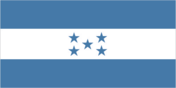
three equal horizontal bands of cerulean blue (top), white, and cerulean blue, with five cerulean, five-pointed stars arranged in an X pattern centered in the white band; the stars represent the members of the former Federal Republic of Central America: Costa Rica, El Salvador, Guatemala, Honduras, and Nicaragua; the blue bands symbolize the Pacific Ocean and the Caribbean Sea; the white band represents the land between the two bodies of water and the peace and prosperity of its people
Government Type
presidential republic
Independence
15 September 1821 (from Spain)
International Law Organization Participation
accepts compulsory ICJ jurisdiction with reservations; accepts ICCt jurisdiction
International Organization Participation
BCIE, CACM, CD, CELAC, EITI (candidate country), FAO, G-11, G-77, IADB, IAEA, IBRD, ICAO, ICCt, ICRM, IDA, IFAD, IFC, IFRCS, ILO, IMF, IMO, Interpol, IOC (suspended), IOM, IPU, ISO (subscriber), ITSO, ITU, ITUC (NGOs), LAES, LAIA (observer), MIGA, MINURSO, MINUSTAH, NAM, OAS, OPANAL, OPCW, Pacific Alliance (observer), PCA, Petrocaribe, SICA, UN, UNCTAD, UNESCO, UNIDO, Union Latina, UNWTO, UPU, WCO (suspended), WFTU (NGOs), WHO, WIPO, WMO, WTO
Judicial Branch
- Highest Courts
- Supreme Court of Justice or Corte Suprema de Justicia (15 principal judges, including the court president, and 7 alternates; court organized into civil, criminal, constitutional, and labor chambers); note - the court has both judicial and constitutional jurisdiction
- Judge Selection And Term Of Office
- court president elected by his peers; judges elected by the National Congress from candidates proposed by the Nominating Board, a diverse 7-member group of judicial officials and other government and non-government officials nominated by each of their organizations; judges elected by Congress for renewable, 7-year terms
- Subordinate Courts
- courts of appeal; courts of first instance; justices of the peace
Legal System
civil law system
Legislative Branch
- Description
- unicameral National Congress or Congreso Nacional (128 seats; members directly elected in multi-seat constituencies by closed, party-list proportional representation vote; members serve 4-year terms)
- Election Results
- percent of vote by party - PNH 47.7%, LIBRE 23.4%, PL 20.3%, AP 3.1%, PINU 3.1%, DC 0.8%, PAC 0.8%, UD 0.8%; seats by party - PNH 61, LIBRE 30, PL 26, AP 4, PINU 4, DC 1, PAC 1, UD 1; composition - men 101, women 27, percent of women 21.1%
- Elections
- last held on 27 November 2017 (next to be held on 28 November 2021)
National Anthem
- Lyrics Music
- Augusto Constancio COELLO/Carlos HARTLING
- Name
- "Himno Nacional de Honduras" (National Anthem of Honduras)
National Holiday
Independence Day, 15 September (1821)
National Symbol S
scarlet macaw, white-tailed deer; national colors: blue, white
Political Parties And Leaders
Alliance against the Dictatorship or Alianza de Oposicion conta la Dictadura [Salvador NASRALLA] (electoral coalition) Anti-Corruption Party or PAC [Marlene ALVARENGA] Christian Democratic Party or DC [Lucas AGUILERA] Democratic Unification Party or UD [Alfonso DIAZ] Freedom and Refoundation Party or LIBRE [Jose Manuel ZELAYA Rosales] Honduran Patriotic Alliance or AP [Romeo VASQUEZ Velasquez] Liberal Party or PL [Luis Orlando ZELAYA Medrano] National Party of Honduras or PNH [Reinaldo SANCHEZ Rivera] Innovation and Unity Party or PINU [Guillermo VALLE]
Suffrage
18 years of age; universal and compulsory
Economy
Agriculture Products
bananas, coffee, citrus, corn, African palm; beef; timber; shrimp, tilapia, lobster, sugar, oriental vegetables
Budget
- Expenditures
- 5.283 billion (2017 est.)
- Revenues
- 4.658 billion (2017 est.)
Budget Surplus Or Deficit
-2.7% (of GDP) (2017 est.)
Central Bank Discount Rate
- 31 December 2010
- 6.25%
Commercial Bank Prime Lending Rate
- 31 December 2016
- 19.33%
- 31 December 2017
- 19.26%
Current Account Balance
- 2016
- -$587 million
- 2017
- -$380 million
Debt External
- 31 December 2016
- $7.852 billion
- 31 December 2017
- $8.625 billion
Distribution Of Family Income Gini Index
- 2009
- 45.7
- 2014
- 47.1
Economy Overview
Honduras, the second poorest country in Central America, suffers from extraordinarily unequal distribution of income, as well as high underemployment. While historically dependent on the export of bananas and coffee, Honduras has diversified its export base to include apparel and automobile wire harnessing.Honduras’s economy depends heavily on US trade and remittances. The US-Central America-Dominican Republic Free Trade Agreement came into force in 2006 and has helped foster foreign direct investment, but physical and political insecurity, as well as crime and perceptions of corruption, may deter potential investors; about 15% of foreign direct investment is from US firms.The economy registered modest economic growth of 3.1%-4.0% from 2010 to 2017, insufficient to improve living standards for the nearly 65% of the population in poverty. In 2017, Honduras faced rising public debt, but its economy has performed better than expected due to low oil prices and improved investor confidence. Honduras signed a three-year standby arrangement with the IMF in December 2014, aimed at easing Honduras’s poor fiscal position.
Exchange Rates
- 2013
- 21.137
- 2014
- 22.098
- 2015
- 22.995
- 2016
- 22.995
- 2017
- 23.74
- Currency
- lempiras (HNL) per US dollar -
Exports
- 2016
- $7.841 billion
- 2017
- $8.675 billion
Exports Commodities
coffee, apparel, coffee, shrimp, automobile wire harnesses, cigars, bananas, gold, palm oil, fruit, lobster, lumber
Exports Partners
US 34.5%, Germany 8.9%, Belgium 7.7%, El Salvador 7.3%, Netherlands 7.2%, Guatemala 5.2%, Nicaragua 4.8% (2017)
Fiscal Year
calendar year
GDP Composition By End Use
- Exports Of Goods And Services
- 43.6% (2017 est.)
- Government Consumption
- 13.8% (2017 est.)
- Household Consumption
- 77.7% (2017 est.)
- Imports Of Goods And Services
- -58.9% (2017 est.)
- Investment In Fixed Capital
- 23.1% (2017 est.)
- Investment In Inventories
- 0.7% (2017 est.)
GDP Composition By Sector Of Origin
- Agriculture
- 14.2% (2017 est.)
- Industry
- 28.8% (2017 est.)
- Services
- 57% (2017 est.)
GDP Official Exchange Rate
$22.98 billion (2017 est.)
GDP Per Capita Ppp
- 2015
- $5,300
- 2016
- $5,400
- 2017
- $5,600
GDP Purchasing Power Parity
- 2015
- $42.58 billion
- 2016
- $44.18 billion
- 2017
- $46.3 billion
GDP Real Growth Rate
- 2015
- 3.8%
- 2016
- 3.8%
- 2017
- 4.8%
Gross National Saving
- 2015
- 20.5% of GDP
- 2016
- 20.6% of GDP
- 2017
- 22.1% of GDP
Household Income Or Consumption By Percentage Share
- Highest 10
- 38.4% (2014)
- Lowest 10
- 1.2%
Imports
- 2016
- $10.56 billion
- 2017
- $11.32 billion
Imports Commodities
communications equipment, machinery and transport, industrial raw materials, chemical products, fuels, foodstuffs
Imports Partners
US 40.3%, Guatemala 10.5%, China 8.5%, Mexico 6.2%, El Salvador 5.7%, Panama 4.4%, Costa Rica 4.2% (2017)
Industrial Production Growth Rate
4.5% (2017 est.)
Industries
sugar processing, coffee, woven and knit apparel, wood products, cigars
Inflation Rate Consumer Prices
- 2016
- 2.7%
- 2017
- 3.9%
Labor Force
3.735 million (2017 est.)
Labor Force By Occupation
- Agriculture
- 39.2%
- Industry
- 20.9%
- Services
- 39.8% (2005 est.)
Market Value Of Publicly Traded Shares
NA
Population Below Poverty Line
29.6% (2014)
Public Debt
- 2016
- 38.5% of GDP
- 2017
- 39.5% of GDP
Reserves Of Foreign Exchange And Gold
- 31 December 2016
- $3.814 billion
- 31 December 2017
- $4.708 billion
Stock Of Broad Money
- 31 December 2016
- $2.455 billion
- 31 December 2017
- $2.827 billion
Stock Of Domestic Credit
- 31 December 2016
- $12.67 billion
- 31 December 2017
- $13.3 billion
Stock Of Narrow Money
- 31 December 2016
- $2.455 billion
- 31 December 2017
- $2.827 billion
Taxes And Other Revenues
20.3% (of GDP) (2017 est.)
Unemployment Rate
- 2016
- 6.3%
- 2017
- 5.6%
Energy
Carbon Dioxide Emissions From Consumption Of Energy
9.436 million Mt (2017 est.)
Crude Oil Exports
0 bbl/day (2015 est.)
Crude Oil Imports
0 bbl/day (2015 est.)
Crude Oil Production
0 bbl/day (2018 est.)
Crude Oil Proved Reserves
0 bbl (1 January 2018 est.)
Electricity Access
- Electrification Rural Areas
- 72.2% (2016)
- Electrification Total Population
- 87.6% (2016)
- Electrification Urban Areas
- 100% (2016)
- Population Without Electricity
- 2 million (2017)
Electricity Consumption
7.22 billion kWh (2016 est.)
Electricity Exports
536 million kWh (2015 est.)
Electricity From Fossil Fuels
40% of total installed capacity (2016 est.)
Electricity From Hydroelectric Plants
25% of total installed capacity (2017 est.)
Electricity From Nuclear Fuels
0% of total installed capacity (2017 est.)
Electricity From Other Renewable Sources
34% of total installed capacity (2017 est.)
Electricity Imports
195 million kWh (2016 est.)
Electricity Installed Generating Capacity
2.546 million kW (2016 est.)
Electricity Production
8.501 billion kWh (2016 est.)
Natural Gas Consumption
0 cu m (2017 est.)
Natural Gas Exports
0 cu m (2017 est.)
Natural Gas Imports
0 cu m (2017 est.)
Natural Gas Production
0 cu m (2017 est.)
Natural Gas Proved Reserves
0 cu m (1 January 2014 est.)
Refined Petroleum Products Consumption
59,000 bbl/day (2016 est.)
Refined Petroleum Products Exports
12,870 bbl/day (2015 est.)
Refined Petroleum Products Imports
56,120 bbl/day (2015 est.)
Refined Petroleum Products Production
0 bbl/day (2017 est.)
Communications
Broadband Fixed Subscriptions
- Subscriptions Per 100 Inhabitants
- 3 (2017 est.)
- Total
- 232,990
Broadcast Media
multiple privately owned terrestrial TV networks, supplemented by multiple cable TV networks; Radio Honduras is the lone government-owned radio network; roughly 300 privately owned radio stations
Internet Country Code
.hn
Internet Users
- Percent Of Population
- 30% (July 2016 est.)
- Total
- 2,667,978
Telephone System
- Domestic
- private sub-operators allowed to provide fixed lines in order to expand telephone coverage contributing to a small increase in fixed-line teledensity 5 per 100; mobile-cellular subscribership is roughly 91 per 100 persons (2018)
- General Assessment
- fixed-line connections are increasing but still limited; competition among multiple providers of mobile-cellular services is contributing to a sharp increase in subscribership; demand for broadband increasing and some investment needed in network upgrades; mobile penetration below regional average (2018)
- International
- country code - 504; landing points for both the ARCOS and the MAYA-1 fiber-optic submarine cable systems that together provide connectivity to South and Central America, parts of the Caribbean, and the US; satellite earth stations - 2 Intelsat (Atlantic Ocean); connected to Central American Microwave System (2019)
Telephones Fixed Lines
- Subscriptions Per 100 Inhabitants
- 5 (2017 est.)
- Total Subscriptions
- 491,107
Telephones Mobile Cellular
- Subscriptions Per 100 Inhabitants
- 91 (2017 est.)
- Total Subscriptions
- 8,233,499
Transportation
Airports
103 (2013)
Airports With Paved Runways
- 1 524 To 2 437 M
- 3 (2017)
- 2 438 To 3 047 M
- 3 (2017)
- 914 To 1 523 M
- 4 (2017)
- Total
- 13 (2017)
- Under 914 M
- 3 (2017)
Airports With Unpaved Runways
- 1 524 To 2 437 M
- 1 (2013)
- 914 To 1 523 M
- 16 (2013)
- Total
- 90 (2013)
- Under 914 M
- 73 (2013)
Civil Aircraft Registration Country Code Prefix
HR (2016)
Merchant Marine
- By Type
- container ship 1, general cargo 249, oil tanker 89, other 211 (2018)
- Total
- 550
National Air Transport System
- Annual Freight Traffic On Registered Air Carriers
- 502,372 mt-km (2015)
- Annual Passenger Traffic On Registered Air Carriers
- 251,149 (2015)
- Inventory Of Registered Aircraft Operated By Air Carriers
- 10 (2015)
- Number Of Registered Air Carriers
- 5 (2015)
Ports And Terminals
La Ceiba, Puerto Cortes, San Lorenzo, Tela
Railways
- Narrow Gauge
- 164 km 1.067-m gauge (2014)
- Total
- 699 km (2014)
Roadways
- Paved
- 3,367 km (2012)
- Total
- 14,742 km (2012)
- Unpaved
- 11,375 km (1,543 km summer only) (2012)
Waterways
465 km (most navigable only by small craft) (2012)
Military and Security
Military And Security Forces
Honduran Armed Forces (Fuerzas Armadas de Honduras, FFAA): Army, Honduran Naval Force (FNH; includes marines), Honduran Air Force (Fuerza Aerea Hondurena, FAH), Honduran Public Order Military Police (PMOP) (2019)
Military Expenditures
- 2014
- 4.62% of GDP
- 2015
- 1.68% of GDP
- 2016
- 1.68% of GDP
- 2017
- 1.74% of GDP
- 2018
- 1.71% of GDP
Military Service Age And Obligation
18 years of age for voluntary 2- to 3-year military service; no conscription (2018)
Transnational Issues
Disputes International
International Court of Justice (ICJ) ruled on the delimitation of "bolsones" (disputed areas) along the El Salvador-Honduras border in 1992 with final settlement by the parties in 2006 after an Organization of American States survey and a further ICJ ruling in 2003; the 1992 ICJ ruling advised a tripartite resolution to a maritime boundary in the Gulf of Fonseca with consideration of Honduran access to the Pacific; El Salvador continues to claim tiny Conejo Island, not mentioned in the ICJ ruling, off Honduras in the Gulf of Fonseca; Honduras claims the Belizean-administered Sapodilla Cays off the coast of Belize in its constitution, but agreed to a joint ecological park around the cays should Guatemala consent to a maritime corridor in the Caribbean under the OAS-sponsored 2002 Belize-Guatemala Differendum
Illicit Drugs
transshipment point for drugs and narcotics; illicit producer of cannabis, cultivated on small plots and used principally for local consumption; corruption is a major problem; some money-laundering activity
Refugees And Internally Displaced Persons
190,000 (violence, extortion, threats, forced recruitment by urban gangs) (2016)