1996 Edition
CIA World Factbook 1996 (Project Gutenberg)
Introduction
Description
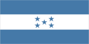
three equal horizontal bands of blue (top), white, and blue with five blue five-pointed stars arranged in an X pattern centered in the white band; the stars represent the members of the former Federal Republic of Central America - Costa Rica, El Salvador, Guatemala, Honduras, and Nicaragua; similar to the flag of El Salvador, which features a round emblem encircled by the words REPUBLICA DE EL SALVADOR EN LA AMERICA CENTRAL centered in the white band; also similar to the flag of Nicaragua, which features a triangle encircled by the word REPUBLICA DE NICARAGUA on top and AMERICA CENTRAL on the bottom, centered in the white band
Location
15 00 N, 86 30 W -- Middle America, bordering the Caribbean Sea, between Guatemala and Nicaragua and bordering the North Pacific Ocean, between El Salvador and Nicaragua Flag ----
Geography
Area
- comparative area
- slightly larger than Tennessee
- land area
- 111,890 sq km
- total area
- 112,090 sq km
Climate
subtropical in lowlands, temperate in mountains
Coastline
820 km
Environment
- current issues
- urban population expanding; deforestation results from logging and the clearing of land for agricultural purposes; further land degradation and soil erosion hastened by uncontrolled development and improper land use practices such as farming of marginal lands; mining activities polluting Lago de Yojoa (the country's largest source of freshwater) with heavy metals as well as several rivers and streams
- international agreements
- party to - Biodiversity, Climate Change, Endangered Species, Law of the Sea, Marine Dumping, Nuclear Test Ban, Ozone Layer Protection, Tropical Timber 83, Wetlands; signed, but not ratified - Desertification, Tropical Timber 94
- natural hazards
- frequent, but generally mild, earthquakes; damaging hurricanes and floods along Caribbean coast
Geographic coordinates
15 00 N, 86 30 W
International disputes
land boundary dispute with El Salvador mostly resolved by 11 September 1992 International Court of Justice (ICJ) decision; with respect to the maritime boundary in the Golfo de Fonseca, ICJ referred to an earlier agreement in this century and advised that some tripartite resolution among El Salvador, Honduras, and Nicaragua likely would be required; maritime boundary dispute with Nicaragua
Irrigated land
900 sq km (1989 est.)
Land boundaries
- border countries
- Guatemala 256 km, El Salvador 342 km, Nicaragua 922 km
- total
- 1,520 km
Land use
- arable land
- 14%
- forest and woodland
- 34%
- meadows and pastures
- 30%
- other
- 20%
- permanent crops
- 2%
Location
Middle America, bordering the Caribbean Sea, between Guatemala and Nicaragua and bordering the North Pacific Ocean, between El Salvador and Nicaragua
Map references
Central America and the Caribbean
Maritime claims
- contiguous zone
- 24 nm
- continental shelf
- natural extension of territory or to 200 nm
- exclusive economic zone
- 200 nm
- territorial sea
- 12 nm
Natural resources
timber, gold, silver, copper, lead, zinc, iron ore, antimony, coal, fish
Terrain
- mostly mountains in interior, narrow coastal plains
- highest point
- Cerro Las Minas 2,870 m
- lowest point
- Caribbean Sea 0 m
People and Society
Age structure
0-14 years: 43% (male 1,220,188; female 1,177,725) 15-64 years: 54% (male 1,496,625; female 1,520,918) 65 years and over: 3% (male 91,126; female 98,611) (July 1996 est.)
Birth rate
33.38 births/1,000 population (1996 est.)
Death rate
5.83 deaths/1,000 population (1996 est.)
Ethnic divisions
mestizo (mixed Indian and European) 90%, Indian 7%, black 2%, white 1%
Infant mortality rate
41.8 deaths/1,000 live births (1996 est.)
Languages
Spanish, Indian dialects
Life expectancy at birth
- female
- 70.96 years (1996 est.)
- male
- 66.01 years
- total population
- 68.42 years
Literacy
- age 15 and over can read and write (1995 est.)
- female
- 72.7%
- male
- 72.6%
- total population
- 72.7%
Nationality
- adjective
- Honduran
- noun
- Honduran(s)
Net migration rate
-1.53 migrant(s)/1,000 population (1996 est.)
Population
5,605,193 (July 1996 est.)
Population growth rate
2.6% (1996 est.)
Religions
Roman Catholic 97%, Protestant minority
Sex ratio
- all ages
- 1 male(s)/female (1996 est.)
- at birth
- 1.05 male(s)/female
- under 15 years
- 1.04 male(s)/female 15-64 years: 0.98 male(s)/female 65 years and over: 0.92 male(s)/female
Total fertility rate
4.41 children born/woman (1996 est.)
Government
Administrative divisions
18 departments (departamentos, singular - departamento); Atlantida, Choluteca, Colon, Comayagua, Copan, Cortes, El Paraiso, Francisco Morazan, Gracias a Dios, Intibuca, Islas de la Bahia, La Paz, Lempira, Ocotepeque, Olancho, Santa Barbara, Valle, Yoro
Capital
Tegucigalpa
Constitution
11 January 1982, effective 20 January 1982
Data code
HO
Diplomatic representation in US
- chancery
- 3007 Tilden Street NW, Washington, DC 20008
- chief of mission
- Ambassador Roberto FLORES Bermudez
- telephone
- [1] (202) 966-7702, 2604, 5008, 4596
Executive branch
- cabinet
- Cabinet
- chief of state and head of government
- President Carlos Roberto REINA Idiaquez (since 27 January 1994) was elected for a four-year term by a simple majority of the people; First Vice President General (Ret.) Walter LOPEZ; Second Vice President Juan DE LA CRUZ Avelar; Third Vice President Guadeloupe JEREZANO; election last held 28 November 1993 (next to be held November 1997); results - Carlos Roberto REINA Idiaquez (PLH) 53%, Oswaldo RAMOS Soto (PNH) 41%, other 6%
FAX
- [1] (202) 966-9751
- [504] 36-9037
- consulate(s)
- Boston, Detroit, and Jacksonville
- consulate(s) general
- Chicago, Houston, Los Angeles, Miami, New Orleans, New York, San Francisco, and San Juan (Puerto Rico)
Flag
three equal horizontal bands of blue (top), white, and blue with five blue five-pointed stars arranged in an X pattern centered in the white band; the stars represent the members of the former Federal Republic of Central America - Costa Rica, El Salvador, Guatemala, Honduras, and Nicaragua; similar to the flag of El Salvador, which features a round emblem encircled by the words REPUBLICA DE EL SALVADOR EN LA AMERICA CENTRAL centered in the white band; also similar to the flag of Nicaragua, which features a triangle encircled by the word REPUBLICA DE NICARAGUA on top and AMERICA CENTRAL on the bottom, centered in the white band
Independence
15 September 1821 (from Spain)
International organization participation
BCIE, CACM, ECLAC, FAO, G-77, IADB, IBRD, ICAO, ICFTU, ICRM, IDA, IFAD, IFC, IFRCS, ILO, IMF, IMO, Intelsat, Interpol, IOC, IOM, ITU, LAES, LAIA (observer), MINURSO, NAM, OAS, OPANAL, PCA, UN, UN Security Council (temporary), UNCTAD, UNESCO, UNIDO, UNMIH, UPU, WCL, WFTU, WHO, WIPO, WMO, WTrO
Judicial branch
Supreme Court of Justice (Corte Suprema de Justica), judges are elected for four-year terms by the National Assembly
Legal system
rooted in Roman and Spanish civil law; some influence of English common law; accepts ICJ jurisdiction, with reservations
Legislative branch
unicameral
Name of country
- conventional long form
- Republic of Honduras
- conventional short form
- Honduras
- local long form
- Republica de Honduras
- local short form
- Honduras
National Congress (Congreso Nacional)
elections last held on 27 November 1993 (next to be held November 1997); results - PNH 53%, PLH 41%, PDCH 1.0%, PINU-SD 2.5%, other 2.5%; seats - (134 total) PNH 55, PLH 77, PINU-SD 2
National holiday
Independence Day, 15 September (1821)
Other political or pressure groups
National Association of Honduran Campesinos (ANACH); Honduran Council of Private Enterprise (COHEP); Confederation of Honduran Workers (CTH); National Union of Campesinos (UNC); General Workers Confederation (CGT); United Federation of Honduran Workers (FUTH); Committee for the Defense of Human Rights in Honduras (CODEH); Coordinating Committee of Popular Organizations (CCOP)
Political parties and leaders
Liberal Party (PLH), Rafael PINEDA Ponce, president; National Party of Honduras (PNH), Oswaldo RAMOS Soto, president; National Innovation and Unity Party (PINU), Olban VALLADARES, president; Christian Democratic Party (PDCH), Efrain DIAZ Arrivillaga, president
Suffrage
18 years of age; universal and compulsory
Type of government
republic
US diplomatic representation
- chief of mission
- Ambassador William T. PRYCE
- embassy
- Avenida La Paz, Apartado Postal No 3453, Tegucigalpa
- mailing address
- American Embassy, APO AA 34022, Tegucigalpa
- telephone
- [504] 36-9320, 38-5114
Economy
Agriculture
bananas, coffee, citrus; beef; timber; shrimp;
Budget
- expenditures
- $668 million, including capital expenditures of $166 million (1993 est.)
- revenues
- $527 million
Currency
1 lempira (L) = 100 centavos
Economic aid
- recipient
- ODA, $NA
Economic overview
Honduras is one of the poorest countries in the Western Hemisphere. Agriculture, the most important sector of the economy, employs nearly two-thirds of the labor force and produces two-thirds of exports. Productivity remains low. Manufacturing, still in its early stages, employs about 9% of the labor force, and generates 20% of exports. Many basic problems face the economy, including rapid population growth, high unemployment, inflation, a lack of basic services, a large and inefficient public sector, and the dependence of the export sector mostly on coffee and bananas, which are subject to sharp price fluctuations. A far-reaching reform program, initiated by former President CALLEJAS in 1990 and scaled back by President REINA, is beginning to take hold.
Electricity
- capacity
- 290,000 kW
- consumption per capita
- 445 kWh (1993)
- production
- 2.3 billion kWh
Exchange rates
lempiras (L) per US$1 - 10.3432 (December 1994), 10.3432 (1995), 9.4001 (1994), 7.2600 (1993), 5.8300 (1992), 5.4000 (1991); the lempira was allowed to float in 1992
Exports
- $843 million (f.o.b., 1994)
- commodities
- bananas, coffee, shrimp, lobster, minerals, meat, lumber
- partners
- US 53%, Germany 11%, Belgium 8%, UK 5%
External debt
$3.7 billion (1994)
Fiscal year
calendar year
GDP
purchasing power parity - $10.8 billion (1995 est.)
GDP composition by sector
- agriculture
- 30%
- industry
- 20%
- services
- 50% (1995 est.)
GDP per capita
$1,980 (1995 est.)
GDP real growth rate
4% (1995 est.)
Illicit drugs
transshipment point for narcotics; illicit producer of cannabis, cultivated on small plots and used principally for local consumption
Imports
- $1.1 billion (c.i.f. 1994)
- commodities
- machinery and transport equipment, chemical products, manufactured goods, fuel and oil, foodstuffs
- partners
- US 50%, Mexico 8%, Guatemala 6%
Industrial production growth rate
10% (1992 est.)
Industries
sugar, coffee, textiles, clothing, wood products
Inflation rate (consumer prices)
30% (1994 est.)
Labor force
- 1.3 million
- by occupation
- agriculture 62%, services 20%, manufacturing 9%, construction 3%, other 6% (1985)
Unemployment rate
10%; underemployed 30%-40% (1992)
Communications
Branches
Army, Navy (includes Marines), Air Force, Public Security Forces (FUSEP)
Defense expenditures
exchange rate conversion - $41 million, about 0.4% of GDP (1994)
Manpower availability
- males age 15-49
- 1,322,525
- males fit for military service
- 787,889
- males reach military age (18) annually
- 64,378 (1996 est.)
Radio broadcast stations
AM 176, FM 0, shortwave 7
Radios
2.115 million (1992 est.)
Telephone system
- inadequate system
- domestic
- NA
- international
- satellite earth stations - 2 Intelsat (Atlantic Ocean); connected to Central American Microwave System
Telephones
105,000 (1992 est.)
Television broadcast stations
28
Televisions
400,000 (1992 est.) Defense
Transportation
Airports
- total
- 111
- with paved runways 1 524 to 2 437 m
- 2
- with paved runways 2 438 to 3 047 m
- 3
- with paved runways 914 to 1 523 m
- 5
- with paved runways under 914 m
- 79
- with unpaved runways 2 438 to 3 047 m
- 1
- with unpaved runways 914 to 1 523 m
- 21 (1995 est.)
Highways
- paved
- 2,533 km
- total
- 14,203 km
- unpaved
- 11,670 km (1993 est.)
Merchant marine
- note
- a flag of convenience registry; Russia owns 8 ships, Vietnam 4, North Korea 2, Greece 1, Japan 1, US 1, Iran 1 (1995 est.)
- ships by type
- bulk 29, cargo 165, chemical tanker 2, combination bulk 1, container 7, liquefied gas tanker 1, livestock carrier 3, oil tanker 19, passenger 1, passenger-cargo 3, refrigerated cargo 16, roll-on/roll-off cargo 7, short-sea passenger 2, vehicle carrier 1
- total
- 257 ships (1,000 GRT or over) totaling 769,518 GRT/1,148,423 DWT
Ports
La Ceiba, Puerto Castilla, Puerto Cortes, San Lorenzo, Tela, Puerto Lempira
Railways
- narrow gauge
- 190 km 1.067-m gauge; 128 km 1.057-m gauge; 277 km 0.914-m gauge
- note
- in 1993, there was a total of 988 km of track (1995)
- total
- 595 km
Waterways
465 km navigable by small craft