2007 Edition
CIA World Factbook 2007 (Project Gutenberg)
Introduction
Administrative divisions
9 regions (regioes, singular - regiao); Bafata, Biombo, Bissau, Bolama, Cacheu, Gabu, Oio, Quinara, Tombali; note - Bolama may have been renamed Bolama/Bijagos
Age structure
0-14 years: 41.4% (male 297,623/female 298,942) 15-64 years: 55.6% (male 384,559/female 417,811) 65 years and over: 3% (male 18,048/female 25,046) (2006 est.)
Agriculture - products
rice, corn, beans, cassava (tapioca), cashew nuts, peanuts, palm kernels, cotton; timber; fish
Airports
28 (2006)
Airports - with paved runways
- over 3,047 m
- 1 1,524 to 2,437 m: 1 914 to 1,523 m: 1 (2006)
- total
- 3
Airports - with unpaved runways
- total
- 25 1,524 to 2,437 m: 1 914 to 1,523 m: 4
- under 914 m
- 20 (2006)
Area
- land
- 28,000 sq km
- total
- 36,120 sq km
- water
- 8,120 sq km
Area - comparative
slightly less than three times the size of Connecticut
Background
Since independence from Portugal in 1974, Guinea-Bissau has experienced considerable political and military upheaval. In 1980, a military coup established authoritarian dictator Joao Bernardo 'Nino' VIEIRA as president. Despite setting a path to a market economy and multiparty system, VIEIRA's regime was characterized by the suppression of political opposition and the purging of political rivals. Several coup attempts through the 1980s and early 1990s failed to unseat him. In 1994 VIEIRA was elected president in the country's first free elections. A military mutiny and resulting civil war in 1998 eventually led to VIEIRA's ouster in May 1999. In February 2000, a transitional government turned over power to opposition leader Kumba YALA, after he was elected president in transparent polling. In September 2003, after only three years in office, YALA was ousted by the military in a bloodless coup, and businessman Henrique ROSA was sworn in as interim president. In 2005, former President VIEIRA was re-elected president pledging to pursue economic development and national reconciliation. Geography Guinea-Bissau
Birth rate
37.22 births/1,000 population (2006 est.)
Budget
- expenditures
- $NA
- revenues
- $NA
Capital
- geographic coordinates
- 11 51 N, 15 35 W
- name
- Bissau
- time difference
- UTC 0 (5 hours ahead of Washington, DC during Standard Time)
Climate
tropical; generally hot and humid; monsoonal-type rainy season (June to November) with southwesterly winds; dry season (December to May) with northeasterly harmattan winds
Coastline
350 km
Constitution
16 May 1984; amended 4 May 1991, 4 December 1991, 26 February 1993, 9 June 1993, NA 1996
Country name
- conventional long form
- Republic of Guinea-Bissau
- conventional short form
- Guinea-Bissau
- former
- Portuguese Guinea
- local long form
- Republica da Guine-Bissau
- local short form
- Guine-Bissau
Currency (code)
Communaute Financiere Africaine franc (XOF); note - responsible authority is the Central Bank of the West African States
Currency code
XOF; GWP
Death rate
16.53 deaths/1,000 population (2006 est.)
Debt - external
$941.5 million (2000 est.)
Diplomatic representation from the US
the US Embassy suspended operations on 14 June 1998 in the midst of violent conflict between forces loyal to then President VIEIRA and military-led junta; the US Ambassador to Senegal is accredited to Guinea-Bissau
Diplomatic representation in the US
- chief of mission
- Ambassador (vacant); note - Guinea-Bissau does not have official representation in Washington, DC
Disputes - international
attempts to stem refugees and cross-border raids, arms smuggling, and political instability from a separatist movement in Senegal's Casamance region
Economic aid - recipient
$115.4 million (1995)
Economy - overview
One of the 10 poorest countries in the world, Guinea-Bissau depends mainly on farming and fishing. Cashew crops have increased remarkably in recent years, and the country now ranks sixth in cashew production. Guinea-Bissau exports fish and seafood along with small amounts of peanuts, palm kernels, and timber. Rice is the major crop and staple food. However, intermittent fighting between Senegalese-backed government troops and a military junta destroyed much of the country's infrastructure and caused widespread damage to the economy in 1998; the civil war led to a 28% drop in GDP that year, with partial recovery in 1999-2002. Before the war, trade reform and price liberalization were the most successful part of the country's structural adjustment program under IMF sponsorship. The tightening of monetary policy and the development of the private sector had also begun to reinvigorate the economy. Because of high costs, the development of petroleum, phosphate, and other mineral resources is not a near-term prospect. However, offshore oil prospecting has begun and could lead to much-needed revenue in the long run. The inequality of income distribution is one of the most extreme in the world. The government and international donors continue to work out plans to forward economic development from a lamentably low base. In December 2003, the World Bank, IMF, and UNDP were forced to step in to provide emergency budgetary support in the amount of $107 million for 2004, representing over 80% of the total national budget. Government drift and indecision, however, have resulted in continued low growth in 2002-06.
Electricity - consumption
53.96 million kWh (2004)
Electricity - exports
0 kWh (2004)
Electricity - imports
0 kWh (2004)
Electricity - production
58.02 million kWh (2004)
Electricity - production by source
- fossil fuel
- 100%
- hydro
- 0%
- nuclear
- 0%
- other
- 0% (2001)
Elevation extremes
- highest point
- unnamed location in the northeast corner of the country 300 m
- lowest point
- Atlantic Ocean 0 m
Environment - current issues
deforestation; soil erosion; overgrazing; overfishing
Environment - international agreements
- party to
- Biodiversity, Climate Change, Desertification, Endangered Species, Law of the Sea, Wetlands
- signed, but not ratified
- none of the selected agreements
Ethnic groups
African 99% (includes Balanta 30%, Fula 20%, Manjaca 14%, Mandinga 13%, Papel 7%), European and mulatto less than 1%
Exchange rates
Communaute Financiere Africaine francs (XOF) per US dollar - 527.47 (2005), 528.29 (2004), 581.2 (2003), 696.99 (2002), note, since 1 January 1999, the XOF franc has been pegged to the euro at a rate of 655.957 XOF francs per euro
Executive branch
- cabinet
- NA
- chief of state
- President Joao Bernardo 'Nino' VIEIRA (since 1 October 2005)
- election results
- Joao Bernardo VIEIRA elected president; percent of vote, second ballot - Joao Bernardo VIEIRA 52.4%, Malam Bacai SANHA 47.6%
- elections
- president elected by popular vote for a five-year term (no term limits); election last held 24 July 2005 (next to be held in 2010); prime minister appointed by the president after consultation with party leaders in the legislature
- head of government
- Prime Minister Aristides GOMES (since 2 November 2005)
Exports
$116 million f.o.b. (2004 est.)
Exports - commodities
cashew nuts, shrimp, peanuts, palm kernels, sawn lumber
Exports - partners
India 71.9%, Nigeria 17.1%, Ecuador 4% (2005)
Fiscal year
calendar year Communications Guinea-Bissau
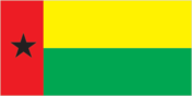
Flag description
two equal horizontal bands of yellow (top) and green with a vertical red band on the hoist side; there is a black five-pointed star centered in the red band; uses the popular pan-African colors of Ethiopia Economy Guinea-Bissau
GDP - composition by sector
- agriculture
- 62%
- industry
- 12%
- services
- 26% (1999 est.)
GDP - per capita (PPP)
$900 (2006 est.)
GDP - real growth rate
2.9% (2006 est.)
GDP (official exchange rate)
$295.1 million (2006 est.)
GDP (purchasing power parity)
$1.244 billion (2006 est.)
Geographic coordinates
12 00 N, 15 00 W
Geography - note
this small country is swampy along its western coast and low-lying further inland People Guinea-Bissau
Government type
republic
HIV/AIDS - adult prevalence rate
10% (2003 est.)
HIV/AIDS - deaths
1,200 (2001 est.)
HIV/AIDS - people living with HIV/AIDS
17,000 (2001 est.)
Household income or consumption by percentage share
- highest 10%
- 42.4% (1991)
- lowest 10%
- 0.5%
Imports
$176 million f.o.b. (2004 est.)
Imports - commodities
foodstuffs, machinery and transport equipment, petroleum products
Imports - partners
Italy 24.8%, Senegal 18.2%, Portugal 15.4%, Cote d'Ivoire 4.2% (2005)
Independence
24 September 1973 (unilaterally declared by Guinea-Bissau); 10 September 1974 (recognized by Portugal)
Industrial production growth rate
4.7% (2003 est.)
Industries
agricultural products processing, beer, soft drinks
Infant mortality rate
- female
- 94.57 deaths/1,000 live births (2006 est.)
- male
- 115.53 deaths/1,000 live births
- total
- 105.21 deaths/1,000 live births
Inflation rate (consumer prices)
4% (2002 est.)
International organization participation
ACCT, ACP, AfDB, AU, ECOWAS, FAO, FZ, G-77, IBRD, ICAO, ICCt (signatory), ICRM, IDA, IDB, IFAD, IFC, IFRCS, ILO, IMF, IMO, Interpol, IOC, IOM, ISO (correspondent), ITU, ITUC, MIGA, NAM, OIC, OIF, OPCW (signatory), UN, UNCTAD, UNESCO, UNIDO, UNWTO, UPU, WADB (regional), WAEMU, WFTU, WHO, WIPO, WMO, WTO
Internet country code
.gw
Internet hosts
5 (2006)
Internet Service Providers (ISPs)
2 (2002)
Internet users
26,000 (2005) Transportation Guinea-Bissau
Irrigated land
250 sq km (2003)
Judicial branch
Supreme Court or Supremo Tribunal da Justica (consists of nine justices appointed by the president and serve at his pleasure; final court of appeals in criminal and civil cases); Regional Courts (one in each of nine regions; first court of appeals for Sectoral Court decisions; hear all felony cases and civil cases valued at over $1,000); 24 Sectoral Courts (judges are not necessarily trained lawyers; they hear civil cases under $1,000 and misdemeanor criminal cases)
Labor force
480,000 (1999)
Labor force - by occupation
- agriculture
- 82%
- industry and services
- 18% (2000 est.)
Land boundaries
- border countries
- Guinea 386 km, Senegal 338 km
- total
- 724 km
Land use
- arable land
- 8.31%
- other
- 84.77% (2005)
- permanent crops
- 6.92%
Languages
Portuguese (official), Crioulo, African languages
Legal system
accepts compulsory ICJ jurisdiction
Legislative branch
- unicameral National People's Assembly or Assembleia Nacional Popular (100 seats; members are elected by popular vote to serve a maximum of four years)
- election results
- percent of vote by party - PAIGC 31.5%, PRS 24.8%, PUSD 16.1%, UE 4.1%, APU 1.3%, 13 other parties 22.2%; seats by party - PAIGC 45, PRS 35, PUSD 17, UE 2, APU 1
- elections
- last held 28 March 2004 (next to be held in 2008)
Life expectancy at birth
- female
- 48.75 years (2006 est.)
- male
- 45.05 years
- total population
- 46.87 years
Literacy
- definition
- age 15 and over can read and write
- female
- 27.4% (2003 est.) Government Guinea-Bissau
- male
- 58.1%
- total population
- 42.4%
Location
Western Africa, bordering the North Atlantic Ocean, between Guinea and Senegal
Major infectious diseases
- degree of risk
- very high
- food or waterborne diseases
- bacterial and protozoal diarrhea, hepatitis A, and typhoid fever
- respiratory disease
- meningococcal meningitis (2007)
- vectorborne diseases
- malaria and yellow fever are high risks in some locations
- water contact disease
- schistosomiasis
Manpower available for military service
- females age 18-49
- 297,295 (2005 est.)
- males age 18-49
- 287,542
Manpower fit for military service
- females age 18-49
- 161,033 (2005 est.)
- males age 18-49
- 152,681
Map references
Africa
Maritime claims
- exclusive economic zone
- 200 nm
- territorial sea
- 12 nm
Median age
- female
- 19.6 years (2006 est.)
- male
- 18.4 years
- total
- 19 years
Military branches
People's Revolutionary Armed Force (FARP; includes Army, Navy, and Air Force), paramilitary force
Military expenditures - dollar figure
$9.46 million (2005 est.)
Military expenditures - percent of GDP
3.1% (2005 est.) Transnational Issues Guinea-Bissau
Military service age and obligation
18 years of age for compulsory military service (2001)
National holiday
Independence Day, 24 September (1973)
Nationality
- adjective
- Guinean
- noun
- Guinean(s)
Natural gas - consumption
0 cu m (2004 est.)
Natural gas - production
0 cu m (2004 est.)
Natural hazards
hot, dry, dusty harmattan haze may reduce visibility during dry season; brush fires
Natural resources
fish, timber, phosphates, bauxite, clay, granite, limestone, unexploited deposits of petroleum
Net migration rate
0 migrant(s)/1,000 population (2006 est.)
Oil - consumption
2,500 bbl/day (2004 est.)
Oil - exports
NA bbl/day (2001)
Oil - imports
NA bbl/day (2001)
Oil - production
0 bbl/day (2004 est.)
Political parties and leaders
African Party for the Independence of Guinea-Bissau and Cape Verde or PAIGC [Carlos GOMES Junior]; Broad Republican Front or FRA (coalition formed by PAIGC, UM, PST, UPG, FCGSD, UE, PP, PDG, PDSG, PRP, and the International League for Ecological Protection); Democratic Social Front or FDS; Electoral Union or UE; Guinea-Bissau Civic Forum/Social Democracy or FCGSD [Antonieta Rosa GOMES]; Guinea-Bissau Democratic Party or PDG; Guinea-Bissau Socialist Democratic Party or PDSG [Serifo BALDE]; Labor and Solidarity Party or PST [Iancuba INDJAI]; Party for Democratic Convergence or PCD; Party for Renewal and Progress or PRP; Party for Social Renewal or PRS [Kumba YALA]; Progress Party or PP; Union for Change or UM [Amine SAAD]; Union of Guinean Patriots or UPG [Francisca VAZ]; United Platform or UP (coalition formed by PCD, FDS, FLING, and RGB-MB); United Popular Alliance or APU; United Social Democratic Party or PUSD
Political pressure groups and leaders
NA
Population
1,442,029 (July 2006 est.)
Population below poverty line
NA%
Population growth rate
2.07% (2006 est.)
Ports and terminals
Bissau, Buba, Cacheu, Farim Military Guinea-Bissau
Radio broadcast stations
AM 1 (transmitter out of service), FM 4, shortwave 0 (2002)
Radios
49,000 (1997)
Refugees and internally displaced persons
- refugees (country of origin)
- 7,320 (Senegal) (2006) This page was last updated on 8 February, 2007
Religions
indigenous beliefs 50%, Muslim 45%, Christian 5%
Roadways
- paved
- 965 km
- total
- 3,455 km
- unpaved
- 2,490 km (2002)
Sex ratio
- at birth
- 1.03 male(s)/female
- total population
- 0.94 male(s)/female (2006 est.)
- under 15 years
- 1 male(s)/female 15-64 years: 0.92 male(s)/female 65 years and over: 0.72 male(s)/female
Suffrage
18 years of age; universal
Telephone system
- domestic
- combination of microwave radio relay, open-wire lines, radiotelephone, and cellular communications
- general assessment
- small system
- international
- country code - 245
Telephones - main lines in use
10,600 (2003)
Telephones - mobile cellular
67,000 (2005)
Television broadcast stations
NA (2005)
Televisions
NA
Terrain
mostly low coastal plain rising to savanna in east
Total fertility rate
4.86 children born/woman (2006 est.)
Unemployment rate
NA%
Waterways
four largest rivers are navigable for some distance; many inlets and creeks give shallow-water access to much of interior (2006)