2014 Edition
CIA World Factbook 2014 Archive (HTML)
Introduction
Background
Spain ceded Guam to the US in 1898. Captured by the Japanese in 1941, it was retaken by the US three years later. The military installations on the island are some of the most strategically important US bases in the Pacific.
Geography
Area
- 544 sq km 544 sq km 0 sq km
- total
- 544 sq km
- water
- 0 sq km
Area - comparative
three times the size of Washington, DC
Climate
tropical marine; generally warm and humid, moderated by northeast trade winds; dry season (January to June), rainy season (July to December); little seasonal temperature variation
Coastline
125.5 km
Elevation extremes
- Pacific Ocean 0 m Mount Lamlam 406 m
- highest point
- Mount Lamlam 406 m
- lowest point
- Pacific Ocean 0 m
Environment - current issues
extirpation of native bird population by the rapid proliferation of the brown tree snake, an exotic, invasive species
Geographic coordinates
13 28 N, 144 47 E
Geography - note
largest and southernmost island in the Mariana Islands archipelago; strategic location in western North Pacific Ocean
Irrigated land
2 sq km (2011)
Land boundaries
0 km
Land use
- 1.85% 16.67% 81.48% (2011)
- arable land
- 1.85%
- other
- 81.48% (2011)
- permanent crops
- 16.67%
Location
Oceania, island in the North Pacific Ocean, about three-quarters of the way from Hawaii to the Philippines
Map references
Oceania
Maritime claims
- 12 nm 200 nm
- exclusive economic zone
- 200 nm
- territorial sea
- 12 nm
Natural hazards
frequent squalls during rainy season; relatively rare but potentially destructive typhoons (June to December)
Natural resources
aquatic wildlife (supporting tourism), fishing (largely undeveloped)
Terrain
volcanic origin, surrounded by coral reefs; relatively flat coralline limestone plateau (source of most fresh water), with steep coastal cliffs and narrow coastal plains in north, low hills in center, mountains in south
People and Society
Age structure
- 26% (male 21,520/female 20,279) 16.9% (male 14,109/female 13,164) 39.3% (male 32,285/female 31,058) 9.3% (male 7,483/female 7,411) 8.2% (male 6,228/female 7,464) (2014 est.)
- 0-14 years
- 26% (male 21,520/female 20,279)
- 15-24 years
- 16.9% (male 14,109/female 13,164)
- 25-54 years
- 39.3% (male 32,285/female 31,058)
- 55-64 years
- 9.3% (male 7,483/female 7,411)
- 65 years and over
- 8.2% (male 6,228/female 7,464) (2014 est.)
Birth rate
17.01 births/1,000 population (2014 est.)
Contraceptive prevalence rate
66.6% percent of women aged 18-44 (2002)
Death rate
5.04 deaths/1,000 population (2014 est.)
Dependency ratios
- 52.1 % 39.3 % 12.8 % 7.8 (2014 est.)
- elderly dependency ratio
- 12.8 %
- potential support ratio
- 7.8 (2014 est.)
- total dependency ratio
- 52.1 %
- youth dependency ratio
- 39.3 %
Drinking water source
- urban: 99.5% of population rural: 99.5% of population total: 99.5% of population urban: 0.5% of population rural: 0.5% of population total: 0.5% of population (2012 est.)
- rural
- 0.5% of population
- total
- 0.5% of population (2012 est.)
- urban
- 0.5% of population
Ethnic groups
Chamorro 37.3%, Filipino 26.3%, white 7.1%, Chuukese 7%, Korean 2.2%, other Pacific Islander 2%, other Asian 2%, Chinese 1.6%, Palauan 1.6%, Japanese 1.5%, Pohnpeian 1.4%, mixed 9.4%, other 0.6% (2010 est.)
HIV/AIDS - adult prevalence rate
NA
HIV/AIDS - deaths
NA
HIV/AIDS - people living with HIV/AIDS
NA
Infant mortality rate
- 5.51 deaths/1,000 live births 5.91 deaths/1,000 live births 5.08 deaths/1,000 live births (2014 est.)
- female
- 5.08 deaths/1,000 live births (2014 est.)
- total
- 5.51 deaths/1,000 live births
Languages
English 43.6%, Filipino 21.2%, Chamorro 17.8%, other Pacific island languages 10%, Asian languages 6.3%, other 1.1% (2010 est.)
Life expectancy at birth
- 78.82 years 75.78 years 82.05 years (2014 est.)
- female
- 82.05 years (2014 est.)
- total population
- 78.82 years
Literacy
- age 15 and over can read and write 99% 99% 99% (1990 est.)
- definition
- age 15 and over can read and write
- female
- 99% (1990 est.)
- male
- 99%
- total population
- 99%
Major urban areas - population
HAGATNA (capital) 169,000 (2011)
Median age
- 29.9 years 29.4 years 30.4 years (2014 est.)
- female
- 30.4 years (2014 est.)
- male
- 29.4 years
- total
- 29.9 years
Nationality
- Guamanian(s) (US citizens) Guamanian
- adjective
- Guamanian
- noun
- Guamanian(s) (US citizens)
Net migration rate
-7.61 migrant(s)/1,000 population (2014 est.)
Population
161,001 (July 2014 est.)
Population growth rate
0.44% (2014 est.)
Religions
Roman Catholic 85%, other 15% (1999 est.)
Sanitation facility access
- urban: 89.8% of population rural: 89.8% of population total: 89.8% of population urban: 10.2% of population rural: 10.2% of population total: 10.2% of population (2012 est.)
- rural
- 10.2% of population
- total
- 10.2% of population (2012 est.)
- urban
- 10.2% of population
Sex ratio
- 1.06 male(s)/female 1.06 male(s)/female 1.07 male(s)/female 1.04 male(s)/female 1.03 male(s)/female 0.84 male(s)/female 1.03 male(s)/female (2014 est.)
- 0-14 years
- 1.06 male(s)/female
- 15-24 years
- 1.07 male(s)/female
- 25-54 years
- 1.04 male(s)/female
- 55-64 years
- 1.03 male(s)/female
- 65 years and over
- 0.84 male(s)/female
- at birth
- 1.06 male(s)/female
- total population
- 1.03 male(s)/female (2014 est.)
Total fertility rate
2.38 children born/woman (2014 est.)
Unemployment, youth ages 15-24
- 29.4% 29.7% 28.9% (2011)
- female
- 28.9% (2011)
- total
- 29.4%
Urbanization
- 93.2% of total population (2011) 1.23% annual rate of change (2010-15 est.)
- rate of urbanization
- 1.23% annual rate of change (2010-15 est.)
- urban population
- 93.2% of total population (2011)
Government
Administrative divisions
none (territory of the US)
Capital
- Hagatna (Agana) 13 28 N, 144 44 E UTC+10 (15 hours ahead of Washington, DC, during Standard Time)
- geographic coordinates
- 13 28 N, 144 44 E
- name
- Hagatna (Agana)
- time difference
- UTC+10 (15 hours ahead of Washington, DC, during Standard Time)
Constitution
effective 1 July 1950; amended many times, last in 2012 (2013)
Country name
- Territory of Guam Guam Guahan Guahan
- conventional long form
- Territory of Guam
- conventional short form
- Guam
- local long form
- Guahan
- local short form
- Guahan
Dependency status
organized, unincorporated territory of the US with policy relations between Guam and the US under the jurisdiction of the Office of Insular Affairs, US Department of the Interior
Diplomatic representation from the US
none (territory of the US)
Diplomatic representation in the US
none (territory of the US)
Executive branch
- President Barack H. OBAMA (since 20 January 2009); Vice President Joseph R. BIDEN (since 20 January 2009) Governor Eddie CALVO (since 3 January 2011); Lieutenant Governor Ray TENORIO (since 3 January 2011) heads of executive departments; appointed by the governor with the consent of the Guam legislature under the US Constitution, residents of unincorporated territories, such as Guam, do not vote in elections for US president and vice president; however, they may vote in Democratic and Republican presidential primary elections; governor and lieutenant governor elected on the same ticket by popular vote for a four-year term (can serve two consecutive terms, then must wait a full term before running again); election last held on 2 November 2010 (next to be held in November 2014) Eddie CALVO elected governor with 50.6% percent of vote against 49.4% for Carl GUTIERREZ; Ray TENORIO elected lieutenant governor
- cabinet
- heads of executive departments; appointed by the governor with the consent of the Guam legislature
- chief of state
- President Barack H. OBAMA (since 20 January 2009); Vice President Joseph R. BIDEN (since 20 January 2009)
- election results
- Eddie CALVO elected governor with 50.6% percent of vote against 49.4% for Carl GUTIERREZ; Ray TENORIO elected lieutenant governor
- elections
- under the US Constitution, residents of unincorporated territories, such as Guam, do not vote in elections for US president and vice president; however, they may vote in Democratic and Republican presidential primary elections; governor and lieutenant governor elected on the same ticket by popular vote for a four-year term (can serve two consecutive terms, then must wait a full term before running again); election last held on 2 November 2010 (next to be held in November 2014)
- head of government
- Governor Eddie CALVO (since 3 January 2011); Lieutenant Governor Ray TENORIO (since 3 January 2011)
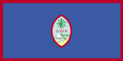
Flag description
territorial flag is dark blue with a narrow red border on all four sides; centered is a red-bordered, pointed, vertical ellipse containing a beach scene, a proa or outrigger canoe with sail, and a palm tree with the word GUAM superimposed in bold red letters; the proa is sailing in Agana Bay with the promontory of Punta Dos Amantes, near the capital, in the background; blue represents the sea and red the blood shed in the struggle against oppression the US flag is the national flag
Government type
NA
Independence
none (territory of the US)
International organization participation
IOC, PIF (observer), SPC, UPU
Judicial branch
- Supreme Court of Guam (consists of 3 justices) note - appeals beyond the Supreme Court of Guam are heard by the US Supreme Court justices appointed by the governor and confirmed by the Guam legislature; justices appointed for life subject to retention election every 10 years Superior Court of Guam - includes several divisions; US Federal District Court for the District of Guam (a US territorial court; appeals beyond this court are heard before the US Court of Appeals for the Ninth Circuit)
- highest court(s)
- Supreme Court of Guam (consists of 3 justices)
- judge selection and term of office
- justices appointed by the governor and confirmed by the Guam legislature; justices appointed for life subject to retention election every 10 years
- subordinate courts
- Superior Court of Guam - includes several divisions; US Federal District Court for the District of Guam (a US territorial court; appeals beyond this court are heard before the US Court of Appeals for the Ninth Circuit)
Legal system
common law modeled on US system; US federal laws apply
Legislative branch
- unicameral Legislature (15 seats; members elected by popular vote to serve two-year terms) last held on 6 November 2012 (next to be held in November 2014) percent of vote by party - NA; seats by party - Democratic Party 9, Republican Party 6 Guam elects one nonvoting delegate to the US House of Representatives; election last held on 6 November 2012 (next to be held in November 2014); results - percent of vote by party - NA; seats by party - Democratic Party 1
- election results
- percent of vote by party - NA; seats by party - Democratic Party 9, Republican Party 6
- elections
- last held on 6 November 2012 (next to be held in November 2014)
National anthem
- "Fanohge Chamoru" (Stand Ye Guamanians) Ramon Manalisay SABLAN [English], Lagrimas UNTALAN [Chamoru]/Ramon Manalisay SABLAN adopted 1919; the local anthem is also known as "Guam Hymn"; as a territory of the United States, "The Star-Spangled Banner," which generally follows the playing of "Stand Ye Guamanians," is official (see United States)
- lyrics/music
- Ramon Manalisay SABLAN [English], Lagrimas UNTALAN [Chamoru]/Ramon Manalisay SABLAN
- name
- "Fanohge Chamoru" (Stand Ye Guamanians)
National holiday
Discovery Day, first Monday in March (1521)
National symbol(s)
coconut tree
Political parties and leaders
Democratic Party [Carlo BRANCH] Republican Party [Mike BENITO]
Political pressure groups and leaders
Guam Commission on Decolonization Guam Federation of Teachers' Union Guam Waterworks Authority Workers We Are Guahan
Suffrage
18 years of age; universal; note - Guamanians are US citizens but do not vote in US presidential elections
Economy
Agriculture - products
fruits, copra, vegetables; eggs, pork, poultry, beef
Budget
- $942.6 million $1.082 billion (FY10/11 est.)
- expenditures
- $1.082 billion (FY10/11 est.)
- revenues
- $942.6 million
Budget surplus (+) or deficit (-)
-3% of GDP (FY10/11 est.)
Debt - external
$NA
Economy - overview
The economy depends largely on US national defense spending, tourism, other services. Total US grants, wages and salaries, and procurement outlays amounted to approximately $1.6 billion in 2010. Over the past 30 years, tourism has grown to become the largest income source following national defense.
Exchange rates
the US dollar is used
Exports
$44 million (2011 est.)
Exports - commodities
transshipments of refined petroleum products, construction materials, fish, food and beverage products
Fiscal year
1 October - 30 September
GDP - composition, by sector of origin
- NA% NA% NA%
- agriculture
- NA%
- industry
- NA%
- services
- NA%
GDP - per capita (PPP)
$28,700 (2010 est.)
GDP - real growth rate
1.3% (2002-10 average est.)
GDP (official exchange rate)
$4.6 billion (2010 est.)
GDP (purchasing power parity)
$4.6 billion (2010 est.)
Household income or consumption by percentage share
- NA% NA%
- highest 10%
- NA%
- lowest 10%
- NA%
Imports
$901 million (2011 est.)
Imports - commodities
petroleum and petroleum products, food, manufactured goods
Industrial production growth rate
NA%
Industries
national defense, tourism, construction, transshipment services, concrete products, printing and publishing, food processing, textiles
Inflation rate (consumer prices)
4% (2011 est.)
Labor force
69,390 this number is for the civilian labor force only (2010 est.)
Labor force - by occupation
- 0.3% (2004 est.) NA% (2004 est.)
- agriculture
- 0.3%
- industry
- (2004 est.)
- services
- NA% (2004 est.)
Population below poverty line
23% (2001 est.)
Taxes and other revenues
20.5% of GDP (FY10/11 est.)
Unemployment rate
8.2% (2010 est.)
Energy
Carbon dioxide emissions from consumption of energy
1.103 million Mt (2011 est.)
Crude oil - exports
0 bbl/day (2010 est.)
Crude oil - imports
0 bbl/day (2010 est.)
Crude oil - production
0 bbl/day (2012 est.)
Crude oil - proved reserves
0 bbl (1 January 2013 est.)
Electricity - consumption
1.635 billion kWh (2010 est.)
Electricity - exports
0 kWh (2012 est.)
Electricity - from fossil fuels
100% of total installed capacity (2010 est.)
Electricity - from hydroelectric plants
0% of total installed capacity (2010 est.)
Electricity - from nuclear fuels
0% of total installed capacity (2010 est.)
Electricity - from other renewable sources
0% of total installed capacity (2010 est.)
Electricity - imports
0 kWh (2012 est.)
Electricity - installed generating capacity
552,000 kW (2010 est.)
Electricity - production
1.734 billion kWh (2011 est.)
Natural gas - consumption
0 cu m (2010 est.)
Natural gas - exports
0 cu m (2011 est.)
Natural gas - imports
0 cu m (2011 est.)
Natural gas - production
0 cu m (2011 est.)
Natural gas - proved reserves
0 cu m (1 January 2013 est.)
Refined petroleum products - consumption
14,490 bbl/day (2011 est.)
Refined petroleum products - exports
0 bbl/day (2010 est.)
Refined petroleum products - imports
6,579 bbl/day (2010 est.)
Refined petroleum products - production
0 bbl/day (2010 est.)
Communications
Broadcast media
about a dozen TV channels, including digital channels; multi-channel cable TV services are available; roughly 20 radio stations (2009)
Internet country code
.gu
Internet hosts
23 (2012)
Internet users
90,000 (2009)
Telephone system
- modern system, integrated with US facilities for direct dialing, including free use of 800 numbers digital system, including mobile-cellular service and local access to the Internet country code - 1-671; major landing point for submarine cables between Asia and the US (Guam is a transpacific communications hub for major carriers linking the US and Asia); satellite earth stations - 2 Intelsat (Pacific Ocean) (2011)
- domestic
- digital system, including mobile-cellular service and local access to the Internet
- general assessment
- modern system, integrated with US facilities for direct dialing, including free use of 800 numbers
- international
- country code - 1-671; major landing point for submarine cables between Asia and the US (Guam is a transpacific communications hub for major carriers linking the US and Asia); satellite earth stations - 2 Intelsat (Pacific Ocean) (2011)
Telephones - main lines in use
67,000 (2012)
Telephones - mobile cellular
98,000 (2004)
Transportation
Airports
5 (2013)
Airports - with paved runways
- 1 (2013)
- 2,438 to 3,047 m
- 1
- 914 to 1,523 m
- 1 (2013)
- over 3,047 m
- 2
- total
- 4
Airports - with unpaved runways
- 1 (2013)
- total
- 1
Ports and terminals
- Apra Harbor
- major seaport(s)
- Apra Harbor
Roadways
- 1,045 km (2008)
- total
- 1,045 km (2008)
Military and Security
Manpower fit for military service
- 38,358 36,869 (2010 est.)
- females age 16-49
- 36,869 (2010 est.)
- males age 16-49
- 38,358
Manpower reaching militarily significant age annually
- 1,701 1,608 (2010 est.)
- female
- 1,608 (2010 est.)
- male
- 1,701
Military - note
defense is the responsibility of the US
Transnational Issues
Disputes - international
none