2011 Edition
CIA World Factbook 2011 Archive (HTML)
Introduction
Background
Carib Indians inhabited Grenada when COLUMBUS discovered the island in 1498, but it remained uncolonized for more than a century. The French settled Grenada in the 17th century, established sugar estates, and imported large numbers of African slaves. Britain took the island in 1762 and vigorously expanded sugar production. In the 19th century, cacao eventually surpassed sugar as the main export crop; in the 20th century, nutmeg became the leading export. In 1967, Britain gave Grenada autonomy over its internal affairs. Full independence was attained in 1974 making Grenada one of the smallest independent countries in the Western Hemisphere. Grenada was seized by a Marxist military council on 19 October 1983. Six days later the island was invaded by US forces and those of six other Caribbean nations, which quickly captured the ringleaders and their hundreds of Cuban advisers. Free elections were reinstituted the following year and have continued since that time. Hurricane Ivan struck Grenada in September of 2004 causing severe damage.
Geography
Area
- 344 sq km 344 sq km 0 sq km
- total
- 344 sq km
- water
- 0 sq km
Area - comparative
twice the size of Washington, DC
Climate
tropical; tempered by northeast trade winds
Coastline
121 km
Elevation extremes
- Caribbean Sea 0 m Mount Saint Catherine 840 m
- highest point
- Mount Saint Catherine 840 m
- lowest point
- Caribbean Sea 0 m
Environment - current issues
NA
Environment - international agreements
- Biodiversity, Climate Change, Climate Change-Kyoto Protocol, Desertification, Endangered Species, Law of the Sea, Ozone Layer Protection, Whaling none of the selected agreements
- party to
- Biodiversity, Climate Change, Climate Change-Kyoto Protocol, Desertification, Endangered Species, Law of the Sea, Ozone Layer Protection, Whaling
- signed, but not ratified
- none of the selected agreements
Geographic coordinates
12 07 N, 61 40 W
Geography - note
the administration of the islands of the Grenadines group is divided between Saint Vincent and the Grenadines and Grenada
Irrigated land
15 sq km (2008)
Land boundaries
0 km
Land use
- 5.88% 29.41% 64.71% (2005)
- arable land
- 5.88%
- other
- 64.71% (2005)
- permanent crops
- 29.41%
Location
Caribbean, island between the Caribbean Sea and Atlantic Ocean, north of Trinidad and Tobago
Map references
Central America and the Caribbean
Maritime claims
- 12 nm 200 nm
- exclusive economic zone
- 200 nm
- territorial sea
- 12 nm
Natural hazards
lies on edge of hurricane belt; hurricane season lasts from June to November
Natural resources
timber, tropical fruit, deepwater harbors
Terrain
volcanic in origin with central mountains
Total renewable water resources
NA
People and Society
Age structure
- 25.4% (male 14,152/female 13,390) 65.7% (male 36,245/female 34,960) 8.9% (male 4,372/female 5,300) (2011 est.)
- 0-14 years
- 25.4% (male 14,152/female 13,390)
- 15-64 years
- 65.7% (male 36,245/female 34,960)
- 65 years and over
- 8.9% (male 4,372/female 5,300) (2011 est.)
Birth rate
17.01 births/1,000 population (2011 est.)
Death rate
7.94 deaths/1,000 population (July 2011 est.)
Drinking water source
- urban: 97% of population rural: 93% of population total: 94% of population urban: 3% of population rural: 7% of population total: 6% of population (2000)
- rural
- 7% of population
- total
- 6% of population (2000)
- urban
- 3% of population
Education expenditures
4.9% of GDP (2003)
Ethnic groups
black 82%, mixed black and European 13%, European and East Indian 5%, and trace of Arawak/Carib Amerindian
Health expenditures
7.1% of GDP (2009)
HIV/AIDS - adult prevalence rate
NA
HIV/AIDS - deaths
NA
HIV/AIDS - people living with HIV/AIDS
NA
Hospital bed density
2.4 beds/1,000 population (2009)
Infant mortality rate
- 11.43 deaths/1,000 live births 10.54 deaths/1,000 live births 12.41 deaths/1,000 live births (2011 est.)
- female
- 12.41 deaths/1,000 live births (2011 est.)
- total
- 11.43 deaths/1,000 live births
Languages
English (official), French patois
Life expectancy at birth
- 73.04 years 70.51 years 75.82 years (2011 est.)
- female
- 75.82 years (2011 est.)
- total population
- 73.04 years
Literacy
- age 15 and over can read and write 96% NA NA (2003 est.)
- definition
- age 15 and over can read and write
- female
- NA (2003 est.)
- male
- NA
- total population
- 96%
Major cities - population
SAINT GEORGE'S (capital) 40,000 (2009)
Median age
- 28.6 years 28.6 years 28.6 years (2011 est.)
- female
- 28.6 years (2011 est.)
- male
- 28.6 years
- total
- 28.6 years
Nationality
- Grenadian(s) Grenadian
- adjective
- Grenadian
- noun
- Grenadian(s)
Net migration rate
-3.56 migrant(s)/1,000 population (2011 est.)
Physicians density
0.9756 physicians/1,000 population (1998)
Population
108,419 (July 2011 est.)
Population growth rate
0.551% (2011 est.)
Religions
Roman Catholic 53%, Anglican 13.8%, other Protestant 33.2%
Sanitation facility access
- urban: 96% of population rural: 97% of population total: 97% of population urban: 4% of population rural: 3% of population total: 3% of population (2008)
- rural
- 3% of population
- total
- 3% of population (2008)
- urban
- 4% of population
School life expectancy (primary to tertiary education)
- 16 years 15 years 16 years (2009)
- female
- 16 years (2009)
- male
- 15 years
- total
- 16 years
Sex ratio
- 1.098 male(s)/female 1.05 male(s)/female 1.04 male(s)/female 0.82 male(s)/female 1.02 male(s)/female (2011 est.)
- 15-64 years
- 1.04 male(s)/female
- 65 years and over
- 0.82 male(s)/female
- at birth
- 1.098 male(s)/female
- total population
- 1.02 male(s)/female (2011 est.)
- under 15 years
- 1.05 male(s)/female
Total fertility rate
2.18 children born/woman (2011 est.)
Urbanization
- 39% of total population (2010) 1.6% annual rate of change (2010-15 est.)
- rate of urbanization
- 1.6% annual rate of change (2010-15 est.)
- urban population
- 39% of total population (2010)
Government
Administrative divisions
6 parishes and 1 dependency*; Carriacou and Petite Martinique*, Saint Andrew, Saint David, Saint George, Saint John, Saint Mark, Saint Patrick
Capital
- Saint George's 12 03 N, 61 45 W UTC-4 (1 hour ahead of Washington, DC during Standard Time)
- geographic coordinates
- 12 03 N, 61 45 W
- name
- Saint George's
- time difference
- UTC-4 (1 hour ahead of Washington, DC during Standard Time)
Constitution
19 December 1973
Country name
- none Grenada
- conventional long form
- none
- conventional short form
- Grenada
Diplomatic representation from the US
- the US Ambassador to Barbados is accredited to Grenada Lance-aux-Epines Stretch, Saint George's P. O. Box 54, Saint George's [1] (473) 444-1173 through 1177 [1] (473) 444-4820
- chief of mission
- the US Ambassador to Barbados is accredited to Grenada
- embassy
- Lance-aux-Epines Stretch, Saint George's
- FAX
- [1] (473) 444-4820
- mailing address
- P. O. Box 54, Saint George's
- telephone
- [1] (473) 444-1173 through 1177
Diplomatic representation in the US
- Ambassador Gillian M.S. BRISTOL 1701 New Hampshire Avenue NW, Washington, DC 20009 [1] (202) 265-2561 [1] (202) 265-2468 New York
- chancery
- 1701 New Hampshire Avenue NW, Washington, DC 20009
- chief of mission
- Ambassador Gillian M.S. BRISTOL
- consulate(s) general
- New York
- FAX
- [1] (202) 265-2468
- telephone
- [1] (202) 265-2561
Executive branch
- Queen ELIZABETH II (since 6 February 1952); represented by Governor General Carlyle Arnold GLEAN (since 27 November 2008) Prime Minister Tillman THOMAS (since 9 July 2008) Cabinet appointed by the governor general on the advice of the prime minister the monarchy is hereditary; governor general appointed by the monarch; following legislative elections, the leader of the majority party or the leader of the majority coalition is usually appointed prime minister by the governor general
- cabinet
- Cabinet appointed by the governor general on the advice of the prime minister
- chief of state
- Queen ELIZABETH II (since 6 February 1952); represented by Governor General Carlyle Arnold GLEAN (since 27 November 2008)
- elections
- the monarchy is hereditary; governor general appointed by the monarch; following legislative elections, the leader of the majority party or the leader of the majority coalition is usually appointed prime minister by the governor general
- head of government
- Prime Minister Tillman THOMAS (since 9 July 2008)
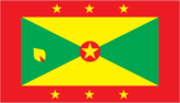
Flag description
a rectangle divided diagonally into yellow triangles (top and bottom) and green triangles (hoist side and outer side), with a red border around the flag; there are seven yellow, five-pointed stars with three centered in the top red border, three centered in the bottom red border, and one on a red disk superimposed at the center of the flag; there is also a symbolic nutmeg pod on the hoist-side triangle (Grenada is the world's second-largest producer of nutmeg, after Indonesia); the seven stars stand for the seven administrative divisions, with the central star denoting the capital, St. George; yellow represents the sun and the warmth of the people, green stands for vegetation and agriculture, and red symbolizes harmony, unity, and courage
Government type
parliamentary democracy and a Commonwealth realm
Independence
7 February 1974 (from the UK)
International law organization participation
has not submitted an ICJ jurisdiction declaration; non-party state to the ICCt
International organization participation
ACP, AOSIS, C, Caricom, CDB, FAO, G-77, IBRD, ICAO, ICRM, IDA, IFAD, IFC, IFRCS, ILO, IMF, IMO, Interpol, IOC, ITU, ITUC, LAES, MIGA, NAM, OAS, OECS, OPANAL, OPCW, PetroCaribe, UN, UNCTAD, UNESCO, UNIDO, UPU, WHO, WIPO, WTO
Judicial branch
Eastern Caribbean Supreme Court, consisting of a court of Appeal and a High Court of Justice (two High Court judges are assigned to and reside in Grenada); Itinerant Court of Appeal three judges; member of the Caribbean Court of Justice (CCJ)
Legal system
common law based on English model
Legislative branch
- bicameral Parliament consists of the Senate (13 seats, 10 members appointed by the government and 3 by the leader of the opposition) and the House of Representatives (15 seats; members elected by popular vote to serve five-year terms) last held on 8 July 2008 (next to be held in 2013) House of Representatives - percent of vote by party - NA; seats by party - NDC 11, NNP 4
- election results
- House of Representatives - percent of vote by party - NA; seats by party - NDC 11, NNP 4
- elections
- last held on 8 July 2008 (next to be held in 2013)
National anthem
- "Hail Grenada" Irva Merle BAPTISTE/Louis Arnold MASANTO adopted 1974
- lyrics/music
- Irva Merle BAPTISTE/Louis Arnold MASANTO
- name
- "Hail Grenada"
National holiday
Independence Day, 7 February (1974)
Political parties and leaders
Grenada United Labor Party or GULP [Gloria Payne BANFIELD]; National Democratic Congress or NDC [Tillman THOMAS]; New National Party or NNP [Keith MITCHELL]
Political pressure groups and leaders
Committee for Human Rights in Grenada or CHRG; New Jewel Movement Support Group; The British Grenada Friendship Society; The New Jewel 19 Committee
Suffrage
18 years of age; universal
Economy
Agriculture - products
bananas, cocoa, nutmeg, mace, citrus, avocados, root crops, sugarcane, corn, vegetables
Budget
- $175.3 million $215.9 million (2009 est.)
- expenditures
- $215.9 million (2009 est.)
- revenues
- $175.3 million
Budget surplus (+) or deficit (-)
-6% of GDP (2009 est.)
Central bank discount rate
6.5% (31 December 2009) 6.5% (31 December 2008)
Commercial bank prime lending rate
10.6% (31 December 2010 est.) 10.983% (31 December 2009 est.)
Current account balance
-$174.8 million (2009 est.) -$174.8 million (2007 est.)
Debt - external
$347 million (2004)
Economy - overview
Grenada relies on tourism as its main source of foreign exchange especially since the construction of an international airport in 1985. Hurricanes Ivan (2004) and Emily (2005) severely damaged the agricultural sector - particularly nutmeg and cocoa cultivation - which had been a key driver of economic growth. Grenada has rebounded from the devastating effects of the hurricanes but is now saddled with the debt burden from the rebuilding process. Public debt-to-GDP is nearly 110%, leaving the THOMAS administration limited room to engage in public investments and social spending. Strong performances in construction and manufacturing, together with the development of tourism and an offshore financial industry, have also contributed to growth in national output; however, economic growth was stagnant in 2010 after a sizeable contraction in 2009, because of the global economic slowdown's effects on tourism and remittances.
Electricity - consumption
177.4 million kWh (2009 est.)
Electricity - exports
0 kWh (2009 est.)
Electricity - imports
0 kWh (2009 est.)
Electricity - production
195.4 million kWh (2009 est.)
Exchange rates
East Caribbean dollars (XCD) per US dollar - 2.7 (2010) 2.7 (2009) 2.7 (2005) 2.7 (2004) 2.7 (2003)
Exports
$38 million (2006) $38.69 million (2009 est.)
Exports - commodities
bananas, cocoa, nutmeg, fruit and vegetables, clothing, mace
Exports - partners
St. Lucia 16.6%, Egypt 15.9%, Antigua and Barbuda 11.3%, US 11%, St. Kitts and Nevis 10.1%, Dominica 10.1% (2010)
GDP - composition by sector
- 10.2% 28.8% 61% (2010 est.)
- agriculture
- 10.2%
- industry
- 28.8%
- services
- 61% (2010 est.)
GDP - per capita (PPP)
$10,200 (2010 est.) $10,400 (2009 est.) $11,300 (2008 est.) data are in 2010 US dollars
GDP - real growth rate
-1.4% (2010 est.) -7.6% (2009 est.) 2.2% (2008 est.)
GDP (official exchange rate)
$674 million (2010 est.)
GDP (purchasing power parity)
$1.098 billion (2010 est.) $1.114 billion (2009 est.) $1.204 billion (2008 est.) data are in 2010 US dollars
Household income or consumption by percentage share
- NA% NA%
- highest 10%
- NA%
- lowest 10%
- NA%
Imports
$252.8 million (2009 est.) $252.8 million (2006)
Imports - commodities
food, manufactured goods, machinery, chemicals, fuel
Imports - partners
Trinidad and Tobago 43.7%, US 18.8% (2010)
Industries
food and beverages, textiles, light assembly operations, tourism, construction
Inflation rate (consumer prices)
5% (2010 est.) -0.3% (2009 est.)
Investment (gross fixed)
15.8% of GDP (2010 est.)
Labor force
42,300 (1996)
Labor force - by occupation
- 24% 14% 62% (1999 est.)
- agriculture
- 24%
- industry
- 14%
- services
- 62% (1999 est.)
Market value of publicly traded shares
$NA
Natural gas - consumption
0 cu m (2009 est.)
Natural gas - exports
0 cu m (2009 est.)
Natural gas - imports
0 cu m (2009 est.)
Natural gas - production
0 cu m (2009 est.)
Natural gas - proved reserves
0 cu m (1 January 2011 est.)
Oil - consumption
3,000 bbl/day (2010 est.)
Oil - exports
0 bbl/day (2009 est.)
Oil - imports
1,913 bbl/day (2009 est.)
Oil - production
0 bbl/day (2010 est.)
Oil - proved reserves
0 bbl (1 January 2011 est.)
Population below poverty line
32% (2000)
Stock of broad money
$821.1 million (31 December 2010 est.) $785.6 million (31 December 2009 est.)
Stock of domestic credit
$598.5 million (31 December 2010 est.) $625.9 million (31 December 2009 est.)
Stock of narrow money
$112.7 million (31 December 2010 est.) $105.9 million (31 December 2009 est.)
Taxes and other revenues
26% of GDP (2009 est.)
Unemployment rate
12.5% (2000)
Communications
Broadcast media
the Grenada Broadcasting Network, jointly owned by the government and the Caribbean Communications Network of Trinidad and Tobago, operates a television station and 2 radio stations; multi-channel cable TV subscription service is available; a dozen private radio stations also broadcast (2007)
Internet country code
.gd
Internet hosts
52 (2010)
Internet users
25,000 (2009)
Telephone system
- automatic, island-wide telephone system interisland VHF and UHF radiotelephone links country code - 1-473; landing point for the East Caribbean Fiber Optic System (ECFS) submarine cable with links to 13 other islands in the eastern Caribbean extending from the British Virgin Islands to Trinidad; SHF radiotelephone links to Trinidad and Tobago and Saint Vincent; VHF and UHF radio links to Trinidad
- domestic
- interisland VHF and UHF radiotelephone links
- general assessment
- automatic, island-wide telephone system
- international
- country code - 1-473; landing point for the East Caribbean Fiber Optic System (ECFS) submarine cable with links to 13 other islands in the eastern Caribbean extending from the British Virgin Islands to Trinidad; SHF radiotelephone links to Trinidad and Tobago and Saint Vincent; VHF and UHF radio links to Trinidad
Telephones - main lines in use
28,400 (2010)
Telephones - mobile cellular
121,900 (2010)
Transportation
Airports
3 (2010)
Airports - with paved runways
- 1 (2010)
- 1,524 to 2,437 m
- 1
- 2,438 to 3,047 m
- 1
- total
- 3
- under 914 m
- 1 (2010)
Ports and terminals
Saint George's
Roadways
- 1,127 km 687 km 440 km (2001)
- total
- 1,127 km
- unpaved
- 440 km (2001)
Military and Security
Manpower available for military service
- 27,468 (2010 est.)
- males age 16-49
- 27,468 (2010 est.)
Manpower fit for military service
- 22,596 22,588 (2010 est.)
- females age 16-49
- 22,588 (2010 est.)
- males age 16-49
- 22,596
Manpower reaching militarily significant age annually
- 1,002 (2010 est.)
- female
- 1,002 (2010 est.)
- male
- 995
Military branches
no regular military forces; Royal Grenada Police Force (includes Coast Guard) (2010)
Military expenditures
NA
Transnational Issues
Disputes - international
none
Illicit drugs
small-scale cannabis cultivation; lesser transshipment point for marijuana and cocaine to US