2014 Edition
CIA World Factbook 2014 Archive (HTML)
Introduction
Background
Formed from the merger of the British colony of the Gold Coast and the Togoland trust territory, Ghana in 1957 became the first sub-Saharan country in colonial Africa to gain its independence. Ghana endured a long series of coups before Lt. Jerry RAWLINGS took power in 1981 and banned political parties. After approving a new constitution and restoring multiparty politics in 1992, RAWLINGS won presidential elections in 1992 and 1996 but was constitutionally prevented from running for a third term in 2000. John KUFUOR succeeded him and was reelected in 2004. John Atta MILLS won the 2008 presidential election and took over as head of state, but he died in July 2012 and was constitutionally succeeded by his vice president John Dramani MAHAMA, who subsequently won the December 2012 presidential election.
Geography
Area
- 238,533 sq km 227,533 sq km 11,000 sq km
- total
- 238,533 sq km
- water
- 11,000 sq km
Area - comparative
slightly smaller than Oregon
Climate
tropical; warm and comparatively dry along southeast coast; hot and humid in southwest; hot and dry in north
Coastline
539 km
Elevation extremes
- Atlantic Ocean 0 m Mount Afadjato 885 m
- highest point
- Mount Afadjato 885 m
- lowest point
- Atlantic Ocean 0 m
Environment - current issues
recurrent drought in north severely affects agricultural activities; deforestation; overgrazing; soil erosion; poaching and habitat destruction threatens wildlife populations; water pollution; inadequate supplies of potable water
Environment - international agreements
- Biodiversity, Climate Change, Climate Change-Kyoto Protocol, Desertification, Endangered Species, Environmental Modification, Hazardous Wastes, Law of the Sea, Ozone Layer Protection, Ship Pollution, Tropical Timber 83, Tropical Timber 94, Wetlands Marine Life Conservation
- party to
- Biodiversity, Climate Change, Climate Change-Kyoto Protocol, Desertification, Endangered Species, Environmental Modification, Hazardous Wastes, Law of the Sea, Ozone Layer Protection, Ship Pollution, Tropical Timber 83, Tropical Timber 94, Wetlands
- signed, but not ratified
- Marine Life Conservation
Freshwater withdrawal (domestic/industrial/agricultural)
- 0.98 cu km/yr (24%/10%/66%) 48.82 cu m/yr (2000)
- per capita
- 48.82 cu m/yr (2000)
- total
- 0.98 cu km/yr (24%/10%/66%)
Geographic coordinates
8 00 N, 2 00 W
Geography - note
Lake Volta is the world's largest artificial lake by surface area (8,482 sq km; 3,275 sq mi)
Irrigated land
309 sq km (2003)
Land boundaries
- 2,420 km Burkina Faso 602 km, Cote d'Ivoire 720 km, Togo 1,098 km
- border countries
- Burkina Faso 602 km, Cote d'Ivoire 720 km, Togo 1,098 km
- total
- 2,420 km
Land use
- 20.12% 11.74% 68.14% (2011)
- arable land
- 20.12%
- other
- 68.14% (2011)
- permanent crops
- 11.74%
Location
Western Africa, bordering the Gulf of Guinea, between Cote d'Ivoire and Togo
Map references
Africa
Maritime claims
- 12 nm 24 nm 200 nm 200 nm
- contiguous zone
- 24 nm
- continental shelf
- 200 nm
- exclusive economic zone
- 200 nm
- territorial sea
- 12 nm
Natural hazards
dry, dusty, northeastern harmattan winds from January to March; droughts
Natural resources
gold, timber, industrial diamonds, bauxite, manganese, fish, rubber, hydropower, petroleum, silver, salt, limestone
Terrain
mostly low plains with dissected plateau in south-central area
Total renewable water resources
53.2 cu km (2011)
People and Society
Age structure
- 38.6% (male 4,988,823/female 4,943,451) 18.7% (male 2,403,526/female 2,426,076) 33.8% (male 4,228,326/female 4,480,090) 4.8% (male 599,510/female 633,688) 4.1% (male 489,566/female 565,052) (2014 est.)
- 0-14 years
- 38.6% (male 4,988,823/female 4,943,451)
- 15-24 years
- 18.7% (male 2,403,526/female 2,426,076)
- 25-54 years
- 33.8% (male 4,228,326/female 4,480,090)
- 55-64 years
- 4.8% (male 599,510/female 633,688)
- 65 years and over
- 4.1% (male 489,566/female 565,052) (2014 est.)
Birth rate
31.4 births/1,000 population (2014 est.)
Child labor - children ages 5-14
- 1,806,750 34 % (2006 est.)
- percentage
- 34 % (2006 est.)
- total number
- 1,806,750
Children under the age of 5 years underweight
14.3% (2008)
Contraceptive prevalence rate
23.5% (2008)
Death rate
7.37 deaths/1,000 population (2014 est.)
Dependency ratios
- 71.6 % 65.6 % 5.9 % 16.8 (2014 est.)
- elderly dependency ratio
- 5.9 %
- potential support ratio
- 16.8 (2014 est.)
- total dependency ratio
- 71.6 %
- youth dependency ratio
- 65.6 %
Drinking water source
- urban: 92.5% of population rural: 81.3% of population total: 87.2% of population urban: 7.5% of population rural: 18.7% of population total: 12.8% of population (2012 est.)
- rural
- 18.7% of population
- total
- 12.8% of population (2012 est.)
- urban
- 7.5% of population
Education expenditures
8.1% of GDP (2011)
Ethnic groups
Akan 47.5%, Mole-Dagbon 16.6%, Ewe 13.9%, Ga-Dangme 7.4%, Gurma 5.7%, Guan 3.7%, Grusi 2.5%, Mande-Busanga 1.1%, other 1.6% (2010 census)
Health expenditures
4.8% of GDP (2011)
HIV/AIDS - adult prevalence rate
1.4% (2012 est.)
HIV/AIDS - deaths
11,600 (2012 est.)
HIV/AIDS - people living with HIV/AIDS
235,800 (2012 est.)
Hospital bed density
0.9 beds/1,000 population (2011)
Infant mortality rate
- 38.52 deaths/1,000 live births 42.58 deaths/1,000 live births 34.34 deaths/1,000 live births (2014 est.)
- female
- 34.34 deaths/1,000 live births (2014 est.)
- total
- 38.52 deaths/1,000 live births
Languages
Asante 14.8%, Ewe 12.7%, Fante 9.9%, Boron (Brong) 4.6%, Dagomba 4.3%, Dangme 4.3%, Dagarte (Dagaba) 3.7%, Akyem 3.4%, Ga 3.4%, Akuapem 2.9%, other (includes English (official)) 36.1% (2000 census)
Life expectancy at birth
- 65.75 years 63.38 years 68.19 years (2014 est.)
- female
- 68.19 years (2014 est.)
- total population
- 65.75 years
Literacy
- age 15 and over can read and write 71.5% 78.3% 65.3% (2010 est.)
- definition
- age 15 and over can read and write
- female
- 65.3% (2010 est.)
- male
- 78.3%
- total population
- 71.5%
Major infectious diseases
- very high bacterial and protozoal diarrhea, hepatitis A, and typhoid fever malaria, dengue fever, and yellow fever schistosomiasis meningococcal meningitis rabies highly pathogenic H5N1 avian influenza has been identified in this country; it poses a negligible risk with extremely rare cases possible among US citizens who have close contact with birds (2013)
- animal contact disease
- rabies
- degree of risk
- very high
- food or waterborne diseases
- bacterial and protozoal diarrhea, hepatitis A, and typhoid fever
- respiratory disease
- meningococcal meningitis
- vectorborne diseases
- malaria, dengue fever, and yellow fever
- water contact disease
- schistosomiasis
Major urban areas - population
ACCRA (capital) 2.573 million; Kumasi 2.019 million (2011)
Maternal mortality rate
350 deaths/100,000 live births (2010)
Median age
- 20.8 years 20.4 years 21.3 years (2014 est.)
- female
- 21.3 years (2014 est.)
- male
- 20.4 years
- total
- 20.8 years
Mother's mean age at first birth
21.8 median age at first birth among women 25-29 (2008 est.)
Nationality
- Ghanaian(s) Ghanaian
- adjective
- Ghanaian
- noun
- Ghanaian(s)
Net migration rate
-2.13 migrant(s)/1,000 population (2014 est.)
Obesity - adult prevalence rate
7.5% (2008)
Physicians density
0.09 physicians/1,000 population (2009)
Population
25,758,108 estimates for this country explicitly take into account the effects of excess mortality due to AIDS; this can result in lower life expectancy, higher infant mortality, higher death rates, lower population growth rates, and changes in the distribution of population by age and sex than would otherwise be expected (July 2014 est.)
Population growth rate
2.19% (2014 est.)
Religions
Christian 71.2% (Pentecostal/Charismatic 28.3%, Protestant 18.4%, Catholic 13.1%, other 11.4%), Muslim 17.6%, traditional 5.2%, other 0.8%, none 5.2% (2010 census)
Sanitation facility access
- urban: 19.9% of population rural: 8.4% of population total: 14.4% of population urban: 80.1% of population rural: 91.6% of population total: 85.6% of population (2012 est.)
- rural
- 91.6% of population
- total
- 85.6% of population (2012 est.)
- urban
- 80.1% of population
School life expectancy (primary to tertiary education)
- 12 years 12 years 11 years (2012)
- female
- 11 years (2012)
- male
- 12 years
- total
- 12 years
Sex ratio
- 1.03 male(s)/female 1.01 male(s)/female 0.99 male(s)/female 0.94 male(s)/female 0.97 male(s)/female 0.88 male(s)/female 0.98 male(s)/female (2014 est.)
- 0-14 years
- 1.01 male(s)/female
- 15-24 years
- 0.99 male(s)/female
- 25-54 years
- 0.94 male(s)/female
- 55-64 years
- 0.97 male(s)/female
- 65 years and over
- 0.88 male(s)/female
- at birth
- 1.03 male(s)/female
- total population
- 0.98 male(s)/female (2014 est.)
Total fertility rate
4.09 children born/woman (2014 est.)
Unemployment, youth ages 15-24
- 16.6% 16.4% 16.7% (2000)
- female
- 16.7% (2000)
- total
- 16.6%
Urbanization
- 51.9% of total population (2011) 3.5% annual rate of change (2010-15 est.)
- rate of urbanization
- 3.5% annual rate of change (2010-15 est.)
- urban population
- 51.9% of total population (2011)
Government
Administrative divisions
10 regions; Ashanti, Brong-Ahafo, Central, Eastern, Greater Accra, Northern, Upper East, Upper West, Volta, Western
Capital
- Accra 5 33 N, 0 13 W UTC 0 (5 hours ahead of Washington, DC, during Standard Time)
- geographic coordinates
- 5 33 N, 0 13 W
- name
- Accra
- time difference
- UTC 0 (5 hours ahead of Washington, DC, during Standard Time)
Constitution
several previous; latest drafted 31 March 1992, approved and promulgated 28 April 1992, entered into force 7 January 1993; amended 1996 (2012)
Country name
- Republic of Ghana Ghana Gold Coast
- conventional long form
- Republic of Ghana
- conventional short form
- Ghana
- former
- Gold Coast
Diplomatic representation from the US
- Ambassador Gene A. CRETZ (since 11 September 2012) 24 Fourth Circular Rd., Cantonments, Accra P. O. Box 194, Accra [233] 30-2741-000 [233] 30-2741-389
- chief of mission
- Ambassador Gene A. CRETZ (since 11 September 2012)
- embassy
- 24 Fourth Circular Rd., Cantonments, Accra
- FAX
- [233] 30-2741-389
- mailing address
- P. O. Box 194, Accra
- telephone
- [233] 30-2741-000
Diplomatic representation in the US
- Ambassador (vacant); Amma Adamaa Twum AMOAH, Charge d'Affaires (since 11 February 2014) 3512 International Drive NW, Washington, DC 20008 [1] (202) 686-4520 [1] (202) 686-4527 New York
- chancery
- 3512 International Drive NW, Washington, DC 20008
- chief of mission
- Ambassador (vacant); Amma Adamaa Twum AMOAH, Charge d'Affaires (since 11 February 2014)
- consulate(s) general
- New York
- FAX
- [1] (202) 686-4527
- telephone
- [1] (202) 686-4520
Executive branch
- President John Dramani MAHAMA (since 24 July 2012); Vice President Kwesi Bekoe AMISSAH-ARTHUR (since 6 August 2012); note - President MAHAMA assumed office due to the death of former president John Atta MILLS and subsequently won the December 2012 presidential election; the president is both the chief of state and head of government President John Dramani MAHAMA (since 24 July 2012); Vice President Kwesi Bekoe AMISSAH-ARTHUR (since 6 August 2012); Council of Ministers; president nominates members subject to approval by Parliament president and vice president elected on the same ticket by popular vote for four-year terms (eligible for a second term); election last held on 7 December 2012, extended to 8 December because of technical difficulties (next to be held in December 2016) John Dramani MAHAMA elected president; percent of vote - John Dramani MAHAMA 50.7%, Nana Addo Dankwa AKUFO-ADDO 47.7%, other 1.6%
- cabinet
- Council of Ministers; president nominates members subject to approval by Parliament
- chief of state
- President John Dramani MAHAMA (since 24 July 2012); Vice President Kwesi Bekoe AMISSAH-ARTHUR (since 6 August 2012); note - President MAHAMA assumed office due to the death of former president John Atta MILLS and subsequently won the December 2012 presidential election; the president is both the chief of state and head of government
- election results
- John Dramani MAHAMA elected president; percent of vote - John Dramani MAHAMA 50.7%, Nana Addo Dankwa AKUFO-ADDO 47.7%, other 1.6%
- elections
- president and vice president elected on the same ticket by popular vote for four-year terms (eligible for a second term); election last held on 7 December 2012, extended to 8 December because of technical difficulties (next to be held in December 2016)
- head of government
- President John Dramani MAHAMA (since 24 July 2012); Vice President Kwesi Bekoe AMISSAH-ARTHUR (since 6 August 2012);
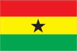
Flag description
three equal horizontal bands of red (top), yellow, and green, with a large black five-pointed star centered in the yellow band; red symbolizes the blood shed for independence, yellow represents the country's mineral wealth, while green stands for its forests and natural wealth; the black star is said to be the lodestar of African freedom uses the popular Pan-African colors of Ethiopia; similar to the flag of Bolivia, which has a coat of arms centered in the yellow band
Government type
constitutional democracy
Independence
6 March 1957 (from the UK)
International law organization participation
has not submitted an ICJ jurisdiction declaration; accepts ICCt jurisdiction
International organization participation
ACP, AfDB, AU, C, ECOWAS, EITI (compliant country), FAO, G-24, G-77, IAEA, IBRD, ICAO, ICC (national committees), ICRM, IDA, IFAD, IFC, IFRCS, ILO, IMF, IMO, IMSO, Interpol, IOC, IOM, IPU, ISO, ITSO, ITU, ITUC (NGOs), MIGA, MINURSO, MINUSMA, MONUSCO, NAM, OAS (observer), OIF, OPCW, UN, UNAMID, UNCTAD, UNESCO, UNHCR, UNIDO, UNIFIL, UNISFA, UNMIL, UNMISS, UNOCI, UNWTO, UPU, WCO, WFTU (NGOs), WHO, WIPO, WMO, WTO
Judicial branch
- Supreme Court (consists of a chief justice and 12 justices) chief justice appointed by the president in consultation with the Council of State (a small advisory body of prominent citizens) and with the approval of Parliament; other justices appointed by the president upon the advice of the Judicial Council (an 18-member independent body of judicial, military and police officials, and presidential nominees) and on the advice of the Council of State; justices can retire at age 60, with compulsory retirement at age 70 Court of Appeal; High Court; Circuit Court; District Court; regional tribunals
- highest court(s)
- Supreme Court (consists of a chief justice and 12 justices)
- judge selection and term of office
- chief justice appointed by the president in consultation with the Council of State (a small advisory body of prominent citizens) and with the approval of Parliament; other justices appointed by the president upon the advice of the Judicial Council (an 18-member independent body of judicial, military and police officials, and presidential nominees) and on the advice of the Council of State; justices can retire at age 60, with compulsory retirement at age 70
- subordinate courts
- Court of Appeal; High Court; Circuit Court; District Court; regional tribunals
Legal system
mixed system of English common law and customary law
Legislative branch
- unicameral Parliament (275 seats; members elected by direct, popular vote in single-seat constituencies to serve four-year terms) last held on 7 and 8 December 2012 (next to be held in December 2016) percent of vote by party - NPP 47.5%, NDC 46.4%, PNC 0.6%, independent 2.5%, other 3.0%; seats by party - NDC 151, NPP 120, PNC 1, independent 3
- election results
- percent of vote by party - NPP 47.5%, NDC 46.4%, PNC 0.6%, independent 2.5%, other 3.0%; seats by party - NDC 151, NPP 120, PNC 1, independent 3
- elections
- last held on 7 and 8 December 2012 (next to be held in December 2016)
National anthem
- "God Bless Our Homeland Ghana" unknown/Philip GBEHO music adopted 1957, lyrics adopted 1966; the lyrics were changed twice, once when a republic was declared in 1960 and again after a 1966 coup
- lyrics/music
- unknown/Philip GBEHO
- name
- "God Bless Our Homeland Ghana"
National holiday
Independence Day, 6 March (1957)
National symbol(s)
black star; golden eagle
Political parties and leaders
Convention People's Party or CPP [Samia NKRUMAH] National Democratic Congress or NDC [John Dramani MAHAMA] New Patriotic Party or NPP [Paul AFOKO] People's National Convention or PNC [Alhaji Amed RAMADAN] note - listed are four of the more popular political parties as of December 2012; there are more than 20 registered parties
Political pressure groups and leaders
Christian Aid (water rights) Committee for Joint Action or CJA (education reform) National Coalition Against the Privatization of Water or CAP (water rights) Oxfam (water rights) Public Citizen (water rights) Students Coalition Against EPA [Kwabena Ososukene OKAI] (education reform) Third World Network (education reform)
Suffrage
18 years of age; universal
Economy
Agriculture - products
cocoa, rice, cassava (manioc, tapioca), peanuts, corn, shea nuts, bananas; timber
Budget
- $10.56 billion $14.87 billion (2013 est.)
- expenditures
- $14.87 billion (2013 est.)
- revenues
- $10.56 billion
Budget surplus (+) or deficit (-)
-9.5% of GDP (2013 est.)
Central bank discount rate
18% (31 December 2009) 17% (31 December 2008)
Commercial bank prime lending rate
27% (31 December 2013 est.) 22.8% (31 December 2012 est.)
Current account balance
-$5.149 billion (2013 est.) -$4.778 billion (2012 est.)
Debt - external
$14.68 billion (31 December 2013 est.) $12.64 billion (31 December 2012 est.)
Distribution of family income - Gini index
39.4 (2005-06) 40.7 (1999)
Economy - overview
Ghana's economy has been strengthened by a quarter century of relatively sound management, a competitive business environment, and sustained reductions in poverty levels. In late 2010, Ghana was recategorized as a lower middle-income country. Ghana is well-endowed with natural resources and agriculture accounts for roughly one-quarter of GDP and employs more than half of the workforce, mainly small landholders. The services sector accounts for 50% of GDP. Gold and cocoa production and individual remittances are major sources of foreign exchange. Oil production at Ghana's offshore Jubilee field began in mid-December 2010,and is producing close to target levels. Additional oil projects are being developed and are expected to come on line in a few years. Estimated oil reserves have jumped to almost 700 million barrels and Ghana’s growing oil industry is expected to boost economic growth as the country faces the consequences of two years of loose fiscal policy, high budget and current account deficits, and a depreciating currency. President MAHAMA faces challenges in managing a population that is unhappy with living standards and that perceives they are not reaping the benefits of oil production because of political corruption.
Exchange rates
cedis (GHC) per US dollar - 2.018 (2013 est.) 1.796 (2012 est.) 1.431 (2010 est.) 1.409 (2009) 1.1 (2008)
Exports
$13.37 billion (2013 est.) $13.54 billion (2012 est.)
Exports - commodities
oil, gold, cocoa, timber, tuna, bauxite, aluminum, manganese ore, diamonds, horticultural products
Exports - partners
France 13.6%, Italy 12.4%, Netherlands 8.9%, China 7.4%, Germany 4.3% (2012)
Fiscal year
calendar year
GDP - composition, by end use
- 64.2% 14.2% 31.7% 0.7% 50.2% -61% (2013 est.)
- exports of goods and services
- 50.2%
- government consumption
- 14.2%
- household consumption
- 64.2%
- imports of goods and services
- -61%
- investment in fixed capital
- 31.7%
- investment in inventories
- 0.7%
GDP - composition, by sector of origin
- 21.5% 28.7% 49.8% (2013 est.)
- agriculture
- 21.5%
- industry
- 28.7%
- services
- 49.8% (2013 est.)
GDP - per capita (PPP)
$3,500 (2013 est.) $3,400 (2012 est.) $3,200 (2011 est.) data are in 2013 US dollars
GDP - real growth rate
7.9% (2013 est.) 7.9% (2012 est.) 15% (2011 est.)
GDP (official exchange rate)
$45.55 billion (2013 est.)
GDP (purchasing power parity)
$90.41 billion (2013 est.) $83.79 billion (2012 est.) $77.64 billion (2011 est.) data are in 2013 US dollars
Gross national saving
21.1% of GDP (2013 est.) 17.9% of GDP (2012 est.) 17.5% of GDP (2011 est.)
Household income or consumption by percentage share
- 2% 32.8% (2006)
- highest 10%
- 32.8% (2006)
- lowest 10%
- 2%
Imports
$18.49 billion (2013 est.) $17.76 billion (2012 est.)
Imports - commodities
capital equipment, refined petroleum, foodstuffs
Imports - partners
China 25.6%, Nigeria 11%, US 7%, Netherlands 6.2%, Singapore 4.5%, UK 4.1%, India 4% (2012)
Industrial production growth rate
10.5% (2013 est.)
Industries
mining, lumbering, light manufacturing, aluminum smelting, food processing, cement, small commercial ship building, petroleum
Inflation rate (consumer prices)
11% (2013 est.) 9.2% (2012 est.)
Labor force
12.07 million (2013 est.)
Labor force - by occupation
- 56% 15% 29% (2005 est.)
- agriculture
- 56%
- industry
- 15%
- services
- 29% (2005 est.)
Market value of publicly traded shares
$3.465 billion (31 December 2012 est.) $3.097 billion (31 December 2011) $3.531 billion (31 December 2010 est.)
Population below poverty line
28.5% (2007 est.)
Public debt
53.1% of GDP (2013 est.) 50% of GDP (2012 est.)
Reserves of foreign exchange and gold
$6.016 billion (31 December 2013 est.) $5.705 billion (31 December 2012 est.)
Stock of broad money
$12.59 billion (31 December 2013 est.) $12.17 billion (31 December 2012 est.)
Stock of direct foreign investment - abroad
$NA
Stock of direct foreign investment - at home
$NA
Stock of domestic credit
$13.31 billion (31 December 2013 est.) $12.56 billion (31 December 2012 est.)
Stock of narrow money
$6.256 billion (31 December 2013 est.) $6.153 billion (31 December 2012 est.)
Taxes and other revenues
23.2% of GDP (2013 est.)
Unemployment rate
11% (2000 est.)
Energy
Carbon dioxide emissions from consumption of energy
9.005 million Mt (2011 est.)
Crude oil - exports
0 bbl/day (2010 est.)
Crude oil - imports
32,060 bbl/day (2010 est.)
Crude oil - production
79,630 bbl/day (2012 est.)
Crude oil - proved reserves
660 million bbl (1 January 2013 est.)
Electricity - consumption
5.311 billion kWh (2010 est.)
Electricity - exports
1.036 billion kWh (2010 est.)
Electricity - from fossil fuels
40.6% of total installed capacity (2010 est.)
Electricity - from hydroelectric plants
59.4% of total installed capacity (2010 est.)
Electricity - from nuclear fuels
0% of total installed capacity (2010 est.)
Electricity - from other renewable sources
0% of total installed capacity (2010 est.)
Electricity - imports
106 million kWh (2010 est.)
Electricity - installed generating capacity
1.985 million kW (2010 est.)
Electricity - production
8.213 billion kWh (2010 est.)
Natural gas - consumption
120 million cu m (2010 est.)
Natural gas - exports
0 cu m (2011 est.)
Natural gas - imports
830 million cu m (2011 est.)
Natural gas - production
50 million cu m (2010 est.)
Natural gas - proved reserves
22.65 billion cu m (1 January 2013 est.)
Refined petroleum products - consumption
61,590 bbl/day (2011 est.)
Refined petroleum products - exports
9,977 bbl/day (2010 est.)
Refined petroleum products - imports
37,240 bbl/day (2010 est.)
Refined petroleum products - production
22,130 bbl/day (2010 est.)
Communications
Broadcast media
state-owned TV station, 2 state-owned radio networks; several privately owned TV stations and a large number of privately owned radio stations; transmissions of multiple international broadcasters are accessible; several cable and satellite TV subscription services are obtainable (2007)
Internet country code
.gh
Internet hosts
59,086 (2012)
Internet users
1.297 million (2009)
Telephone system
- primarily microwave radio relay; wireless local loop has been installed; outdated and unreliable fixed-line infrastructure heavily concentrated in Accra competition among multiple mobile-cellular providers has spurred growth with a subscribership of more than 80 per 100 persons and rising country code - 233; landing point for the SAT-3/WASC, Main One, and GLO-1 fiber-optic submarine cables that provide connectivity to South Africa, Europe, and Asia; satellite earth stations - 4 Intelsat (Atlantic Ocean); microwave radio relay link to Panaftel system connects Ghana to its neighbors (2009)
- domestic
- competition among multiple mobile-cellular providers has spurred growth with a subscribership of more than 80 per 100 persons and rising
- general assessment
- primarily microwave radio relay; wireless local loop has been installed; outdated and unreliable fixed-line infrastructure heavily concentrated in Accra
- international
- country code - 233; landing point for the SAT-3/WASC, Main One, and GLO-1 fiber-optic submarine cables that provide connectivity to South Africa, Europe, and Asia; satellite earth stations - 4 Intelsat (Atlantic Ocean); microwave radio relay link to Panaftel system connects Ghana to its neighbors (2009)
Telephones - main lines in use
285,000 (2012)
Telephones - mobile cellular
25.618 million (2012)
Transportation
Airports
10 (2013)
Airports - with paved runways
- 2 (2013)
- 1,524 to 2,437 m
- 3
- 2,438 to 3,047 m
- 1
- 914 to 1,523 m
- 2 (2013)
- over 3,047 m
- 1
- total
- 7
Airports - with unpaved runways
- 3 (2013)
- 914 to 1,523 m
- 3 (2013)
- total
- 3
Merchant marine
- petroleum tanker 1, refrigerated cargo 3 2 (Brazil 1, South Korea 1) (2010)
- foreign-owned
- 2 (Brazil 1, South Korea 1) (2010)
- total
- 4
Pipelines
gas 394 km; oil 20 km; refined products 361 km (2013)
Ports and terminals
- Takoradi, Tema
- major seaport(s)
- Takoradi, Tema
Railways
- 947 km 947 km 1.067-m gauge (2008)
- total
- 947 km
Roadways
- 109,515 km 13,787 km 95,728 km (2009)
- total
- 109,515 km
- unpaved
- 95,728 km (2009)
Waterways
1,293 km (168 km for launches and lighters on Volta, Ankobra, and Tano rivers; 1,125 km of arterial and feeder waterways on Lake Volta) (2011)
Military and Security
Manpower available for military service
- 6,268,191 6,194,339 (2010 est.)
- females age 16-49
- 6,194,339 (2010 est.)
- males age 16-49
- 6,268,191
Manpower fit for military service
- 4,136,406 4,220,761 (2010 est.)
- females age 16-49
- 4,220,761 (2010 est.)
- males age 16-49
- 4,136,406
Manpower reaching militarily significant age annually
- 267,896 260,992 (2010 est.)
- female
- 260,992 (2010 est.)
- male
- 267,896
Military branches
Ghana Army, Ghana Navy, Ghana Air Force (2012)
Military expenditures
0.27% of GDP (2012) 0.25% of GDP (2011) 0.27% of GDP (2010)
Military service age and obligation
18-26 years of age for voluntary military service, with basic education certificate; no conscription; must be HIV/AIDS negative (2012)
Transnational Issues
Disputes - international
disputed maritime border between Ghana and Cote d'Ivoire
Illicit drugs
illicit producer of cannabis for the international drug trade; major transit hub for Southwest and Southeast Asian heroin and, to a lesser extent, South American cocaine destined for Europe and the US; widespread crime and money laundering problem, but the lack of a well-developed financial infrastructure limits the country's utility as a money laundering center; significant domestic cocaine and cannabis use
Refugees and internally displaced persons
- 9,567 (Cote d'Ivoire; flight from 2010 post-election fighting); 5,249 (Liberia) (2013)
- refugees (country of origin)
- 9,567 (Cote d'Ivoire; flight from 2010 post-election fighting); 5,249 (Liberia) (2013)