2017 Edition
CIA World Factbook 2017 Archive (HTML)
Introduction
Background
Unique among African countries, the ancient Ethiopian monarchy maintained its freedom from colonial rule with the exception of a short-lived Italian occupation from 1936-41. In 1974, a military junta, the Derg, deposed Emperor Haile SELASSIE (who had ruled since 1930) and established a socialist state. Torn by bloody coups, uprisings, wide-scale drought, and massive refugee problems, the regime was finally toppled in 1991 by a coalition of rebel forces, the Ethiopian People's Revolutionary Democratic Front. A constitution was adopted in 1994, and Ethiopia's first multiparty elections were held in 1995. A border war with Eritrea in the late 1990s ended with a peace treaty in December 2000. In November 2007, the Eritrea-Ethiopia Border Commission (EEBC) issued specific coordinates as virtually demarcating the border and pronounced its work finished. Alleging that the EEBC acted beyond its mandate in issuing the coordinates, Ethiopia has not accepted them and has not withdrawn troops from previously contested areas pronounced by the EEBC as belonging to Eritrea. In August 2012, longtime leader Prime Minister MELES Zenawi died in office and was replaced by his Deputy Prime Minister HAILEMARIAM Desalegn, marking the first peaceful transition of power in decades.
Geography
Area
- 1,104,300 sq km 1 million sq km 104,300 sq km
- land
- 1 million sq km
- total
- 1,104,300 sq km
- water
- 104,300 sq km
Area - comparative
slightly less than twice the size of Texas
Climate
tropical monsoon with wide topographic-induced variation
Coastline
0 km (landlocked)
Elevation
- 1,330 m lowest point: Danakil Depression -125 m highest point: Ras Dejen 4,550 m
- elevation extremes
- lowest point: Danakil Depression -125 m
- highest point
- Ras Dejen 4,550 m
- mean elevation
- 1,330 m
Environment - current issues
deforestation; overgrazing; soil erosion; desertification; water shortages in some areas from water-intensive farming and poor management
Environment - international agreements
- Biodiversity, Climate Change, Climate Change-Kyoto Protocol, Desertification, Endangered Species, Hazardous Wastes, Ozone Layer Protection Environmental Modification, Law of the Sea
- party to
- Biodiversity, Climate Change, Climate Change-Kyoto Protocol, Desertification, Endangered Species, Hazardous Wastes, Ozone Layer Protection
- signed, but not ratified
- Environmental Modification, Law of the Sea
Geographic coordinates
8 00 N, 38 00 E
Geography - note
- landlocked - entire coastline along the Red Sea was lost with the de jure independence of Eritrea on 24 May 1993; Ethiopia is, therefore, the most populous landlocked country in the world; the Blue Nile, the chief headstream of the Nile by water volume, rises in T'ana Hayk (Lake Tana) in northwest Ethiopia; three major crops are believed to have originated in Ethiopia: coffee, grain sorghum, and castor bean
- landlocked - entire coastline along the Red Sea was lost with the de jure independence of Eritrea on 24 May 1993; Ethiopia is, therefore, the most populous landlocked country in the world; the Blue Nile, the chief headstream of the Nile by water volume, r
- coffee, grain sorghum, and castor bean
Irrigated land
2,900 sq km (2012)
Land boundaries
- 5,925 km Djibouti 342 km, Eritrea 1,033 km, Kenya 867 km, Somalia 1,640 km, South Sudan 1,299 km, Sudan 744 km
- border countries (6)
- Djibouti 342 km, Eritrea 1,033 km, Kenya 867 km, Somalia 1,640 km, South Sudan 1,299 km, Sudan 744 km
- total
- 5,925 km
Land use
- 36.3% arable land 15.2%; permanent crops 1.1%; permanent pasture 20% 12.2% 51.5% (2011 est.)
- agricultural land
- 36.3%
- forest
- 12.2%
- other
- 51.5% (2011 est.)
Location
Eastern Africa, west of Somalia
Map references
Africa
Maritime claims
none (landlocked)
Natural hazards
- geologically active Great Rift Valley susceptible to earthquakes, volcanic eruptions; frequent droughts volcanic activity in the Great Rift Valley; Erta Ale (613 m), which has caused frequent lava flows in recent years, is the country's most active volcano; Dabbahu became active in 2005, forcing evacuations; other historically active volcanoes include Alayta, Dalaffilla, Dallol, Dama Ali, Fentale, Kone, Manda Hararo, and Manda-Inakir
- volcanism
- volcanic activity in the Great Rift Valley; Erta Ale (613 m), which has caused frequent lava flows in recent years, is the country's most active volcano; Dabbahu became active in 2005, forcing evacuations; other historically active volcanoes include Alayta, Dalaffilla, Dallol, Dama Ali, Fentale, Kone, Manda Hararo, and Manda-Inakir
Natural resources
small reserves of gold, platinum, copper, potash, natural gas, hydropower
Population - distribution
highest density is found in the highlands of the north and middle areas of the country, particularly around the centrally located capital city of Addis Ababa; the far east and southeast are sparsely populated
Terrain
high plateau with central mountain range divided by Great Rift Valley
People and Society
Age structure
- 43.47% (male 22,963,502/female 22,826,957) 20.11% (male 10,516,591/female 10,669,695) 29.58% (male 15,464,171/female 15,702,104) 3.91% (male 1,998,711/female 2,115,210) 2.94% (male 1,391,339/female 1,701,740) (2017 est.)
- 0-14 years
- 43.47% (male 22,963,502/female 22,826,957)
- 15-24 years
- 20.11% (male 10,516,591/female 10,669,695)
- 25-54 years
- 29.58% (male 15,464,171/female 15,702,104)
- 55-64 years
- 3.91% (male 1,998,711/female 2,115,210)
- 65 years and over
- 2.94% (male 1,391,339/female 1,701,740) (2017 est.)
Birth rate
36.5 births/1,000 population (2017 est.)
Children under the age of 5 years underweight
23.6% (2016)
Contraceptive prevalence rate
39.2% (2016)
Death rate
7.7 deaths/1,000 population (2017 est.)
Demographic profile
Ethiopia is a predominantly agricultural country – more than 80% of the population lives in rural areas – that is in the early stages of demographic transition. Infant, child, and maternal mortality have fallen sharply over the past decade, but the total fertility rate has declined more slowly and the population continues to grow. The rising age of marriage and the increasing proportion of women remaining single have contributed to fertility reduction. While the use of modern contraceptive methods among married women has increased significantly from 6 percent in 2000 to 27 percent in 2012, the overall rate is still quite low. Ethiopia’s rapid population growth is putting increasing pressure on land resources, expanding environmental degradation, and raising vulnerability to food shortages. With more than 40 percent of the population below the age of 15 and a fertility rate of over 5 children per woman (and even higher in rural areas), Ethiopia will have to make further progress in meeting its family planning needs if it is to achieve the age structure necessary for reaping a demographic dividend in the coming decades. Poverty, drought, political repression, and forced government resettlement have driven Ethiopia’s internal and external migration since the 1960s. Before the 1974 revolution, only small numbers of the Ethiopian elite went abroad to study and then returned home, but under the brutal Derg regime thousands fled the country, primarily as refugees. Between 1982 and 1991 there was a new wave of migration to the West for family reunification. Since the defeat of the Derg in 1991, Ethiopians have migrated to escape violence among some of the country’s myriad ethnic groups or to pursue economic opportunities. Internal and international trafficking of women and children for domestic work and prostitution is a growing problem.
Dependency ratios
- 82.1 75.8 6.3 15.8 (2015 est.)
- elderly dependency ratio
- 6.3
- potential support ratio
- 15.8 (2015 est.)
- total dependency ratio
- 82.1
- youth dependency ratio
- 75.8
Drinking water source
- urban: 93.1% of population rural: 48.6% of population total: 57.3% of population urban: 6.9% of population rural: 51.4% of population total: 42.7% of population (2015 est.)
- rural
- 51.4% of population
- total
- 42.7% of population (2015 est.)
- urban
- 6.9% of population
Education expenditures
4.5% of GDP (2013)
Ethnic groups
Oromo 34.4%, Amhara (Amara) 27%, Somali (Somalie) 6.2%, Tigray (Tigrinya) 6.1%, Sidama 4%, Gurage 2.5%, Welaita 2.3%, Hadiya 1.7%, Afar (Affar) 1.7%, Gamo 1.5%, Gedeo 1.3%, Silte 1.3%, Kefficho 1.2%, other 8.8% (2007 est.)
Health expenditures
4.9% of GDP (2014)
HIV/AIDS - adult prevalence rate
1.1% (2016 est.)
HIV/AIDS - deaths
20,000 (2016 est.)
HIV/AIDS - people living with HIV/AIDS
710,000 (2016 est.)
Hospital bed density
6.3 beds/1,000 population (2011)
Infant mortality rate
- 49.6 deaths/1,000 live births 56.9 deaths/1,000 live births 42.2 deaths/1,000 live births (2017 est.)
- female
- 42.2 deaths/1,000 live births (2017 est.)
- male
- 56.9 deaths/1,000 live births
- total
- 49.6 deaths/1,000 live births
Languages
Oromo (official working language in the State of Oromiya) 33.8%, Amharic (official national language) 29.3%, Somali (official working language of the State of Sumale) 6.2%, Tigrigna (Tigrinya) (official working language of the State of Tigray) 5.9%, Sidamo 4%, Wolaytta 2.2%, Gurage 2%, Afar (official working language of the State of Afar) 1.7%, Hadiyya 1.7%, Gamo 1.5%, Gedeo 1.3%, Opuuo 1.2%, Kafa 1.1%, other 8.1%, English (major foreign language taught in schools), Arabic (2007 est.)
Life expectancy at birth
- 62.6 years 60.1 years 65.1 years (2017 est.)
- female
- 65.1 years (2017 est.)
- male
- 60.1 years
- total population
- 62.6 years
Literacy
- age 15 and over can read and write 49.1% 57.2% 41.1% (2015 est.)
- definition
- age 15 and over can read and write
- female
- 41.1% (2015 est.)
- male
- 57.2%
- total population
- 49.1%
Major infectious diseases
- very high bacterial and protozoal diarrhea, hepatitis A, and typhoid fever malaria and dengue fever meningococcal meningitis rabies schistosomiasis (2016)
- animal contact disease
- rabies
- degree of risk
- very high
- food or waterborne diseases
- bacterial and protozoal diarrhea, hepatitis A, and typhoid fever
- respiratory disease
- meningococcal meningitis
- vectorborne diseases
- malaria and dengue fever
- water contact disease
- schistosomiasis (2016)
Major urban areas - population
ADDIS ABABA (capital) 3.238 million (2015)
Maternal mortality rate
353 deaths/100,000 live births (2015 est.)
Median age
- 17.9 years 17.7 years 18.1 years (2017 est.)
- female
- 18.1 years (2017 est.)
- male
- 17.7 years
- total
- 17.9 years
Mother's mean age at first birth
- 20 years median age at first birth among women 25-29 (2016 est.)
- note
- median age at first birth among women 25-29 (2016 est.)
Nationality
- Ethiopian(s) Ethiopian
- adjective
- Ethiopian
- noun
- Ethiopian(s)
Net migration rate
-0.2 migrant(s)/1,000 population (2017 est.)
Obesity - adult prevalence rate
4.5% (2016)
Physicians density
0.03 physicians/1,000 population (2009)
Population
- 105,350,020 estimates for this country explicitly take into account the effects of excess mortality due to AIDS; this can result in lower life expectancy, higher infant mortality, higher death rates, lower population growth rates, and changes in the distribution of population by age and sex than would otherwise be expected (July 2017 est.)
- note
- estimates for this country explicitly take into account the effects of excess mortality due to AIDS; this can result in lower life expectancy, higher infant mortality, higher death rates, lower population growth rates, and changes in the distribution of population by age and sex than would otherwise be expected (July 2017 est.)
Population distribution
highest density is found in the highlands of the north and middle areas of the country, particularly around the centrally located capital city of Addis Ababa; the far east and southeast are sparsely populated
Population growth rate
2.85% (2017 est.)
Religions
Ethiopian Orthodox 43.5%, Muslim 33.9%, Protestant 18.5%, traditional 2.7%, Catholic 0.7%, other 0.6% (2007 est.)
Sanitation facility access
- urban: 27.2% of population rural: 28.2% of population total: 28% of population urban: 72.8% of population rural: 71.8% of population total: 72% of population (2015 est.)
- rural
- 71.8% of population
- total
- 72% of population (2015 est.)
- urban
- 72.8% of population
School life expectancy (primary to tertiary education)
- 8 years 9 years 8 years (2012)
- female
- 8 years (2012)
- male
- 9 years
- total
- 8 years
Sex ratio
- 1.03 male(s)/female 1.01 male(s)/female 0.99 male(s)/female 0.99 male(s)/female 0.95 male(s)/female 0.82 male(s)/female 0.99 male(s)/female (2016 est.)
- 0-14 years
- 1.01 male(s)/female
- 15-24 years
- 0.99 male(s)/female
- 25-54 years
- 0.99 male(s)/female
- 55-64 years
- 0.95 male(s)/female
- 65 years and over
- 0.82 male(s)/female
- at birth
- 1.03 male(s)/female
- total population
- 0.99 male(s)/female (2016 est.)
Total fertility rate
4.99 children born/woman (2017 est.)
Unemployment, youth ages 15-24
- 26.7% 22% 30.4% (2014 est.)
- female
- 30.4% (2014 est.)
- male
- 22%
- total
- 26.7%
Urbanization
- 20.4% of total population (2017) 4.64% annual rate of change (2015-20 est.)
- rate of urbanization
- 4.64% annual rate of change (2015-20 est.)
- urban population
- 20.4% of total population (2017)
Government
Administrative divisions
9 ethnically based states (kililoch, singular - kilil) and 2 self-governing administrations* (astedaderoch, singular - astedader); Adis Abeba* (Addis Ababa), Afar, Amara (Amhara), Binshangul Gumuz, Dire Dawa*, Gambela Hizboch (Gambela Peoples), Hareri Hizb (Harari People), Oromiya (Oromia), Sumale (Somali), Tigray, Ye Debub Biheroch Bihereseboch na Hizboch (Southern Nations, Nationalities and Peoples)
Capital
- Addis Ababa 9 02 N, 38 42 E UTC+3 (8 hours ahead of Washington, DC, during Standard Time)
- geographic coordinates
- 9 02 N, 38 42 E
- name
- Addis Ababa
- time difference
- UTC+3 (8 hours ahead of Washington, DC, during Standard Time)
Citizenship
- no at least one parent must be a citizen of Ethiopia no 4 years
- citizenship by birth
- no
- citizenship by descent only
- at least one parent must be a citizen of Ethiopia
- dual citizenship recognized
- no
- residency requirement for naturalization
- 4 years
Constitution
- several previous; latest drafted June 1994, adopted 8 December 1994, entered into force 21 August 1995 proposals submitted for discussion require two-thirds majority approval in either house of Parliament or majority approval of one-third of the State Councils; passage of amendments other than constitutional articles on fundamental rights and freedoms and the initiation and amendment of the constitution requires two-thirds majority vote in a joint session of Parliament and majority vote by two-thirds of the State Councils; passage of amendments affecting rights and freedoms and amendment procedures requires two-thirds majority vote in each house of Parliament and majority vote by all the State Councils (2017)
- amendments
- proposals submitted for discussion require two-thirds majority approval in either house of Parliament or majority approval of one-third of the State Councils; passage of amendments other than constitutional articles on fundamental rights and freedoms and the initiation and amendment of the constitution requires two-thirds majority vote in a joint session of Parliament and majority vote by two-thirds of the State Councils; passage of amendments affecting rights and freedoms and amendment procedures requires two-thirds majority vote in each house of Parliament and majority vote by all the State Councils (2017)
- history
- several previous; latest drafted June 1994, adopted 8 December 1994, entered into force 21 August 1995
Country name
- Federal Democratic Republic of Ethiopia Ethiopia Ityop'iya Federalawi Demokrasiyawi Ripeblik Ityop'iya Abyssinia, Italian East Africa FDRE the country name derives from the Greek word "Aethiopia," which in classical times referred to lands south of Egypt in the Upper Nile region
- abbreviation
- FDRE
- conventional long form
- Federal Democratic Republic of Ethiopia
- conventional short form
- Ethiopia
- etymology
- the country name derives from the Greek word "Aethiopia," which in classical times referred to lands south of Egypt in the Upper Nile region
- former
- Abyssinia, Italian East Africa
- local long form
- Ityop'iya Federalawi Demokrasiyawi Ripeblik
- local short form
- Ityop'iya
Diplomatic representation from the US
- Ambassador Michael RAYNOR (since 3 October 2017) Entoto Street, Addis Ababa P.O. Box 1014, Addis Ababa [251] 11 130-6000 124-2401 [251] 11 124 2401
- chief of mission
- Ambassador Michael RAYNOR (since 3 October 2017)
- embassy
- Entoto Street, Addis Ababa
- FAX
- 124-2401 [251] 11 124 2401
- mailing address
- P.O. Box 1014, Addis Ababa
- telephone
- [251] 11 130-6000
Diplomatic representation in the US
- Ambassador GIRMA Birru Geda (since 6 January 2011) 3506 International Drive NW, Washington, DC 20008 [1] (202) 364-1200 [1] (202) 587-0195 Los Angeles, Seattle Houston, New York
- chancery
- 3506 International Drive NW, Washington, DC 20008
- chief of mission
- Ambassador GIRMA Birru Geda (since 6 January 2011)
- consulate(s)
- Houston, New York
- consulate(s) general
- Los Angeles, Seattle
- FAX
- [1] (202) 587-0195
- telephone
- [1] (202) 364-1200
Executive branch
- President MULATU Teshome Wirtu (since 7 October 2013) Prime Minister HAILEMARIAM Desalegn (since 21 September 2012); Deputy Prime Minister DEMEKE Mekonnen Hassen Council of Ministers selected by the prime minister and approved by the House of People's Representatives president indirectly elected by both chambers of Parliament for a 6-year term (eligible for a second term); election last held on 7 October 2013 (next to be held in October 2019); prime minister designated by the majority party following legislative elections MULATU Teshome Wirtu (OPDO) elected president; Parliament vote - 659 (unanimous)
- cabinet
- Council of Ministers selected by the prime minister and approved by the House of People's Representatives
- chief of state
- President MULATU Teshome Wirtu (since 7 October 2013)
- election results
- MULATU Teshome Wirtu (OPDO) elected president; Parliament vote - 659 (unanimous)
- elections/appointments
- president indirectly elected by both chambers of Parliament for a 6-year term (eligible for a second term); election last held on 7 October 2013 (next to be held in October 2019); prime minister designated by the majority party following legislative elections
- head of government
- Prime Minister HAILEMARIAM Desalegn (since 21 September 2012); Deputy Prime Minister DEMEKE Mekonnen Hassen
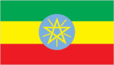
Flag description
- three equal horizontal bands of green (top), yellow, and red, with a yellow pentagram and single yellow rays emanating from the angles between the points on a light blue disk centered on the three bands; green represents hope and the fertility of the land, yellow symbolizes justice and harmony, while red stands for sacrifice and heroism in the defense of the land; the blue of the disk symbolizes peace and the pentagram represents the unity and equality of the nationalities and peoples of Ethiopia Ethiopia is the oldest independent country in Africa, and the three main colors of her flag (adopted ca. 1895) were so often appropriated by other African countries upon independence that they became known as the Pan-African colors; the emblem in the center of the current flag was added in 1996
- note
- Ethiopia is the oldest independent country in Africa, and the three main colors of her flag (adopted ca. 1895) were so often appropriated by other African countries upon independence that they became known as the Pan-African colors; the emblem in the center of the current flag was added in 1996
Government type
federal parliamentary republic
Independence
oldest independent country in Africa and one of the oldest in the world - at least 2,000 years (may be traced to the Aksumite Kingdom, which coalesced in the first century B.C.)
International law organization participation
has not submitted an ICJ jurisdiction declaration; non-party state to the ICCt
International organization participation
ACP, AfDB, AU, COMESA, EITI (candidate country), FAO, G-24, G-77, IAEA, IBRD, ICAO, ICRM, IDA, IFAD, IFC, IFRCS, IGAD, ILO, IMF, IMO, Interpol, IOC, IOM, IPU, ISO, ITSO, ITU, ITUC (NGOs), MIGA, NAM, OPCW, PCA, UN, UN Security Council (temporary), UNAMID, UNCTAD, UNESCO, UNHCR, UNIDO, UNISFA, UNMIL, UNOCI, UNWTO, UPU, WCO, WFTU (NGOs), WHO, WIPO, WMO, WTO (observer)
Judicial branch
- Federal Supreme Court (consists of 11 judges); note - the House of Federation has jurisdiction for all constitutional issues president and vice president of Federal Supreme Court recommended by the prime minister and appointed by the House of People's Representatives; other Supreme Court judges nominated by the Federal Judicial Administrative Council (a 10-member body chaired by the president of the Federal Supreme Court) and appointed by the House of People's Representatives; judges serve until retirement at age 60 federal high courts and federal courts of first instance; state court systems (mirror structure of federal system); sharia courts and customary and traditional courts
- highest court(s)
- Federal Supreme Court (consists of 11 judges); note - the House of Federation has jurisdiction for all constitutional issues
- judge selection and term of office
- president and vice president of Federal Supreme Court recommended by the prime minister and appointed by the House of People's Representatives; other Supreme Court judges nominated by the Federal Judicial Administrative Council (a 10-member body chaired by the president of the Federal Supreme Court) and appointed by the House of People's Representatives; judges serve until retirement at age 60
- subordinate courts
- federal high courts and federal courts of first instance; state court systems (mirror structure of federal system); sharia courts and customary and traditional courts
Legal system
civil law system
Legislative branch
- bicameral Parliament consists of the House of Federation or Yefedereshein Mikir Bete (153 seats; members indirectly elected by state assemblies to serve 5-year terms) and the House of People's Representatives or Yehizb Tewokayoch Mekir Bete (547 seats; members directly elected in single-seat constituencies by simple majority vote; 22 seats reserved for minorities; all members serve 5-year terms); note - the House of Federation is responsible for interpreting the constitution and federal-regional issues and the House of People's Representatives is responsible for passing legislation last held on 24 May 2015 (next to be held in 2020) House of Representatives percent of vote by party/coalition - NA; seats by party/coalition - EPRDF 501, SPDP 24, BGPDUP 9, ANDP 8, GPUDM 3, APDO 1, HNL 1
- election results
- House of Representatives percent of vote by party/coalition - NA; seats by party/coalition - EPRDF 501, SPDP 24, BGPDUP 9, ANDP 8, GPUDM 3, APDO 1, HNL 1
- elections
- last held on 24 May 2015 (next to be held in 2020)
National anthem
- "Whedefit Gesgeshi Woud Enat Ethiopia" (March Forward, Dear Mother Ethiopia) DEREJE Melaku Mengesha/SOLOMON Lulu adopted 1992
- lyrics/music
- DEREJE Melaku Mengesha/SOLOMON Lulu
- name
- "Whedefit Gesgeshi Woud Enat Ethiopia" (March Forward, Dear Mother Ethiopia)
- note
- adopted 1992
National holiday
Derg Downfall Day (defeat of MENGISTU regime), 28 May (1991)
National symbol(s)
- Abyssinian lion (traditional), yellow pentagram with five rays of light on a blue field (promoted by current government); national colors: green, yellow, red
- Abyssinian lion (traditional), yellow pentagram with five rays of light on a blue field (promoted by current government); national colors
- green, yellow, red
Political parties and leaders
Afar National Democratic Party or ANDP [Taha AHMED] Argoba People Democratic Organization or APDO Benishangul Gumuz People's Democratic Unity Party or BGPDUP Blue Party (Semayawi Party) [Solomon TESSEMA, spokesman] Ethiopian Federal Democratic Unity Forum or MEDREK [Beyene PETROS] (a 4-party alliance) Ethiopian People's Revolutionary Democratic Front or EPRDF [Hailemarian DESALEGN] (includes Amhara National Democratic Movement or ANDM; Oromo People's Democratic Organization or OPDO; Southern Ethiopian People's Democratic Movement or SEPDM; Tigray People's Liberation Front or TPLF) Gambella Peoples Unity Democratic Movement or GPUDM Harari National League or HNL [Murad ABDULHADI] Somali People's Democratic Party or SPDP
Political pressure groups and leaders
Ginbot 7 Movement Ogaden National Liberation Front or ONLF Oromo Liberation Front or OLF [DAOUD Ibsa]
Suffrage
18 years of age; universal
Economy
Agriculture - products
cereals, coffee, oilseed, cotton, sugarcane, vegetables, khat, cut flowers; hides, cattle, sheep, goats; fish
Budget
- $11.16 billion $13.58 billion (2016 est.)
- expenditures
- $13.58 billion (2016 est.)
- revenues
- $11.16 billion
Budget surplus (+) or deficit (-)
-3.3% of GDP (2016 est.)
Central bank discount rate
NA%
Commercial bank prime lending rate
12.2% (31 December 2016 est.) 11.5% (31 December 2015 est.)
Current account balance
$-7.206 billion (2016 est.) $-9.206 billion (2015 est.)
Debt - external
$24.82 billion (31 December 2016 est.) $20.41 billion (31 December 2015 est.)
Distribution of family income - Gini index
33 (2011) 30 (2000)
Economy - overview
Ethiopia - the second most populous country in Africa - is a one-party state with a planned economy. For more than a decade before 2016, Ethiopia grew at a rate between 8% and 11% annually – one of the fastest growing states among the 188 IMF member countries. This growth was driven by government investment in infrastructure, as well as sustained progress in the agricultural and service sectors. More than 70% of Ethiopia’s population is still employed in the agricultural sector, but services have surpassed agriculture as the principal source of GDP. Ethiopia has the lowest level of income-inequality in Africa and one of the lowest in the world, with a Gini coefficient comparable to that of the Scandinavian countries. Yet despite progress toward eliminating extreme poverty, Ethiopia remains one of the poorest countries in the world, due both to rapid population growth and a low starting base. Changes in rainfall associated with world-wide weather patterns resulted in the worst drought in 30 years in 2015-16, creating food insecurity for millions of Ethiopians. The state is heavily engaged in the economy. Ongoing infrastructure projects include power production and distribution, roads, rails, airports and industrial parks. Key sectors are state-owned, including telecommunications, banking and insurance, and power distribution. Under Ethiopia's constitution, the state owns all land and provides long-term leases to tenants. Title rights in urban areas, particularly Addis Ababa, are poorly regulated, and subject to corruption. Ethiopia’s foreign exchange earnings are led by the services sector - primarily the state-run Ethiopian Airlines - followed by exports of several commodities. While coffee remains the largest foreign exchange earner, Ethiopia is diversifying exports, and commodities such as gold, sesame, khat, livestock and horticulture products are becoming increasingly important. Manufacturing represented less than 8% of total exports in 2016, but manufacturing exports should increase in future years due to a growing international presence. The banking, insurance, telecommunications, and micro-credit industries are restricted to domestic investors, but Ethiopia has attracted roughly $8.5 billion in foreign direct investment, mostly from China, Turkey, India and the EU; US FDI is $567 million. Investment has been primarily in infrastructure, construction, agriculture/horticulture, agricultural processing, textiles, leather and leather products. In the fall of 2015, the government finalized and published the current 2016-20 five-year plan, known as the Growth and Transformation Plan II, which emphasizes developing manufacturing in sectors where Ethiopia has a comparative advantage, such as textiles and garments, leather goods, and processed agricultural products. To support industrialization, Ethiopia plans to increase installed power generation capacity by 8,320 MW, up from a capacity of 2,000 MW, by building three more major dams and expanding to other sources of renewable energy.
Exchange rates
birr (ETB) per US dollar - 21.732 (2016 est.) 21.732 (2015 est.) 21.55 (2014 est.) 19.8 (2013 est.) 17.71 (2012 est.)
Exports
$2.814 billion (2016 est.) $2.891 billion (2015 est.)
Exports - commodities
coffee (27%, by value), oilseeds (17%), edible vegetables including khat (17%), gold (13%), flowers (7%), live animals (7%), raw leather products (3%), meat products (3%)
Exports - partners
US 9.7%, Saudi Arabia 9.6%, Germany 8.5%, Switzerland 7.5%, China 5.1%, UAE 4.9%, Pakistan 4.4% (2016)
Fiscal year
8 July - 7 July
GDP - composition, by end use
- 70.2% 9.7% 39.8% -0.1% 8% -27.8% (2016 est.)
- exports of goods and services
- 8%
- government consumption
- 9.7%
- household consumption
- 70.2%
- imports of goods and services
- -27.8% (2016 est.)
- investment in fixed capital
- 39.8%
- investment in inventories
- -0.1%
GDP - composition, by sector of origin
- 37.2% 21.3% 41.5% (2016 est.)
- agriculture
- 37.2%
- industry
- 21.3%
- services
- 41.5% (2016 est.)
GDP - per capita (PPP)
- $1,900 (2016 est.) $1,800 (2015 est.) $1,700 (2014 est.) data are in 2016 dollars
- note
- data are in 2016 dollars
GDP - real growth rate
8% (2016 est.) 10.4% (2015 est.) 10.3% (2014 est.)
GDP (official exchange rate)
$72.52 billion (2016 est.)
GDP (purchasing power parity)
- $177.4 billion (2016 est.) $162.3 billion (2015 est.) $145.4 billion (2014 est.) data are in 2016 dollars
- note
- data are in 2016 dollars
Gross national saving
32% of GDP (2016 est.) 31.3% of GDP (2015 est.) 30.7% of GDP (2014 est.)
Household income or consumption by percentage share
- 4.1% 25.6% (2005)
- highest 10%
- 25.6% (2005)
- lowest 10%
- 4.1%
Imports
$16.03 billion (2016 est.) $17.51 billion (2015 est.)
Imports - commodities
machinery and aircraft (14%, by value), metal and metal products, (14%), electrical materials, (13%), petroleum products (12%), motor vehicles, (10%), chemicals and fertilizers (4%)
Imports - partners
China 28.8%, US 8%, India 6.7%, Kuwait 5% (2016)
Industrial production growth rate
20.6% (2016 est.)
Industries
food processing, beverages, textiles, leather, garments, chemicals, metals processing, cement
Inflation rate (consumer prices)
7.3% (2016 est.) 10.1% (2015 est.)
Labor force
51.05 million (2016 est.)
Labor force - by occupation
- 72.7% 7.4% 19.9% (2013 est.)
- agriculture
- 72.7%
- industry
- 7.4%
- services
- 19.9% (2013 est.)
Market value of publicly traded shares
$NA
Population below poverty line
29.6% (2014 est.)
Public debt
54.5% of GDP (2016 est.) 58% of GDP (2015 est.)
Reserves of foreign exchange and gold
$3.022 billion (31 December 2016 est.) $3.827 billion (31 December 2015 est.)
Stock of broad money
$28.21 billion (31 December 2016 est.) $25.24 billion (31 December 2015 est.)
Stock of domestic credit
$36.37 billion (31 December 2016 est.) $29.35 billion (31 December 2015 est.)
Stock of narrow money
$14.56 billion (31 December 2016 est.) $12.34 billion (31 December 2015 est.)
Taxes and other revenues
15.4% of GDP (2016 est.)
Unemployment rate
17.5% (2012 est.) 18% (2011 est.)
Energy
Carbon dioxide emissions from consumption of energy
9.3 million Mt (2013 est.)
Crude oil - exports
0 bbl/day (2014 est.)
Crude oil - imports
0 bbl/day (2014 est.)
Crude oil - production
0 bbl/day (2016 est.)
Crude oil - proved reserves
428,000 bbl (1 January 2017 es)
Electricity - consumption
8.143 billion kWh (2015 est.)
Electricity - exports
166 million kWh (2015 est.)
Electricity - from fossil fuels
7.5% of total installed capacity (2015 est.)
Electricity - from hydroelectric plants
79.5% of total installed capacity (2015 est.)
Electricity - from nuclear fuels
0% of total installed capacity (2015 est.)
Electricity - from other renewable sources
13.4% of total installed capacity (2015 est.)
Electricity - imports
0 kWh (2016 est.)
Electricity - installed generating capacity
2.704 million kW (2015 est.)
Electricity - production
10.08 billion kWh (2015 est.)
Electricity access
- 71,200,000 24% 85% 10% (2013)
- electrification - rural areas
- 10% (2013)
- electrification - total population
- 24%
- electrification - urban areas
- 85%
- population without electricity
- 71,200,000
Natural gas - consumption
0 cu m (2013 est.)
Natural gas - exports
0 cu m (2013 est.)
Natural gas - imports
0 cu m (2013 est.)
Natural gas - production
0 cu m (2013 est.)
Natural gas - proved reserves
24.92 billion cu m (1 January 2017 es)
Refined petroleum products - consumption
65,000 bbl/day (2015 est.)
Refined petroleum products - exports
0 bbl/day (2014 est.)
Refined petroleum products - imports
64,380 bbl/day (2014 est.)
Refined petroleum products - production
0 bbl/day (2014 est.)
Communications
Broadcast media
6 public TV stations broadcasting nationally and 10 public radio broadcasters; 7 private radio stations and 19 community radio stations (2017)
Internet country code
.et
Internet users
- 15,731,741 15.4% (July 2016 est.)
- percent of population
- 15.4% (July 2016 est.)
- total
- 15,731,741
Telephone system
- Ethio Telecom maintains a monopoly over telecommunication services; open-wire, microwave radio relay; radio communication in the HF, VHF, and UHF frequencies; 2 domestic satellites provide the national trunk service the number of mobile telephones is increasing steadily from a small base and now stands at over 50 per 100 persons country code - 251; open-wire to Sudan and Djibouti; microwave radio relay to Kenya and Djibouti; satellite earth stations - 3 Intelsat (1 Atlantic Ocean and 2 Pacific Ocean) (2016)
- domestic
- the number of mobile telephones is increasing steadily from a small base and now stands at over 50 per 100 persons
- general assessment
- Ethio Telecom maintains a monopoly over telecommunication services; open-wire, microwave radio relay; radio communication in the HF, VHF, and UHF frequencies; 2 domestic satellites provide the national trunk service
- international
- country code - 251; open-wire to Sudan and Djibouti; microwave radio relay to Kenya and Djibouti; satellite earth stations - 3 Intelsat (1 Atlantic Ocean and 2 Pacific Ocean) (2016)
Telephones - fixed lines
- 1.147 million 1 (July 2016 est.)
- subscriptions per 100 inhabitants
- 1 (July 2016 est.)
- total subscriptions
- 1.147 million
Telephones - mobile cellular
- 51.224 million 50 (July 2016 est.)
- subscriptions per 100 inhabitants
- 50 (July 2016 est.)
- total
- 51.224 million
Transportation
Airports
57 (2013)
Airports - with paved runways
- 2 (2017)
- 1,524 to 2,437 m
- 4
- 2,438 to 3,047 m
- 8
- over 3,047 m
- 3
- total
- 17
- under 914 m
- 2 (2017)
Airports - with unpaved runways
- 8 (2013)
- 1,524 to 2,437 m
- 9
- 2,438 to 3,047 m
- 3
- 914 to 1,523 m
- 20
- total
- 40
- under 914 m
- 8 (2013)
Civil aircraft registration country code prefix
ET (2016)
Merchant marine
- cargo 8 (2010)
- by type
- cargo 8 (2010)
- total
- 8
National air transport system
- 7,074,779 1,228,738,320 mt-km (2015)
- annual freight traffic on registered air carriers
- 1,228,738,320 mt-km (2015)
- annual passenger traffic on registered air carriers
- 7,074,779
- inventory of registered aircraft operated by air carriers
- 75
- number of registered air carriers
- 1
Ports and terminals
Ethiopia is landlocked and uses the ports of Djibouti in Djibouti and Berbera in Somalia
Railways
- 659 km (Ethiopian segment of the 756 km Addis Ababa-Djibouti railroad) 659 km 1.435-m gauge electric railway with redundant power supplies; under joint control of Djibouti and Ethiopia and managed by a Chinese contractor (2017)
- note
- electric railway with redundant power supplies; under joint control of Djibouti and Ethiopia and managed by a Chinese contractor (2017)
- standard gauge
- 659 km 1.435-m gauge
- total
- 659 km (Ethiopian segment of the 756 km Addis Ababa-Djibouti railroad)
Roadways
- 110,414 km 14,354 km 96,060 km (2015)
- paved
- 14,354 km
- total
- 110,414 km
- unpaved
- 96,060 km (2015)
Military and Security
Military branches
- Ethiopian National Defense Force (ENDF): Ground Forces, Ethiopian Air Force (Ye Ityopya Ayer Hayl, ETAF) (2013)
- Ethiopian National Defense Force (ENDF)
- Ground Forces, Ethiopian Air Force (Ye Ityopya Ayer Hayl, ETAF) (2013)
Military expenditures
0.67% of GDP (2016) 0.71% of GDP (2015) 0.77% of GDP (2014) 0.81% of GDP (2013) 0.87% of GDP (2012)
Military service age and obligation
18 years of age for voluntary military service; no compulsory military service, but the military can conduct callups when necessary and compliance is compulsory (2012)
Transnational Issues
Disputes - international
Eritrea and Ethiopia agreed to abide by the 2002 Eritrea-Ethiopia Boundary Commission's (EEBC) delimitation decision, but neither party responded to the revised line detailed in the November 2006 EEBC Demarcation Statement; the undemarcated former British administrative line has little meaning as a political separation to rival clans within Ethiopia's Ogaden and southern Somalia's Oromo region; Ethiopian forces invaded southern Somalia and routed Islamist courts from Mogadishu in January 2007; "Somaliland" secessionists provide port facilities in Berbera and trade ties to landlocked Ethiopia; civil unrest in eastern Sudan has hampered efforts to demarcate the porous boundary with Ethiopia
Illicit drugs
transit hub for heroin originating in Southwest and Southeast Asia and destined for Europe, as well as cocaine destined for markets in southern Africa; cultivates qat (khat) for local use and regional export, principally to Djibouti and Somalia (legal in all three countries); the lack of a well-developed financial system limits the country's utility as a money laundering center
Refugees and internally displaced persons
- 411,896 (South Sudan) (refugees and asylum seekers); 252,385 (Somalia) (refugees and asylum seekers); 163,281 (Eritrea) (refugees and asylum seekers); 43,251 (Sudan) (refugees and asylum seekers) (2017) 258,000 (border war with Eritrea from 1998-2000; ethnic clashes; and ongoing fighting between the Ethiopian military and separatist rebel groups in the Sumale and Oromiya regions; natural disasters; intercommunal violence; most IDPs live in Sumale state) (2016)
- IDPs
- 258,000 (border war with Eritrea from 1998-2000; ethnic clashes; and ongoing fighting between the Ethiopian military and separatist rebel groups in the Sumale and Oromiya regions; natural disasters; intercommunal violence; most IDPs live in Sumale state) (2016)
- refugees (country of origin)
- 411,896 (South Sudan) (refugees and asylum seekers); 252,385 (Somalia) (refugees and asylum seekers); 163,281 (Eritrea) (refugees and asylum seekers); 43,251 (Sudan) (refugees and asylum seekers) (2017)