2013 Edition
CIA World Factbook 2013 Archive (HTML)
Introduction
Background
Autonomy for the Swazis of southern Africa was guaranteed by the British in the late 19th century; independence was granted in 1968. Student and labor unrest during the 1990s pressured King MSWATI III, Africa's last absolute monarch, to grudgingly allow political reform and greater democracy, although he has backslid on these promises in recent years. A constitution came into effect in 2006, but the legal status of political parties remains unclear. The African United Democratic Party tried unsuccessfully to register as an official political party in mid 2006. Talks over the constitution broke down between the government and progressive groups in 2007. Swaziland recently surpassed Botswana as the country with the world's highest known HIV/AIDS prevalence rate.
Geography
Area
- 17,364 sq km 17,204 sq km 160 sq km
- total
- 17,364 sq km
- water
- 160 sq km
Area - comparative
slightly smaller than New Jersey
Climate
varies from tropical to near temperate
Coastline
0 km (landlocked)
Elevation extremes
- Great Usutu River 21 m Emlembe 1,862 m
- highest point
- Emlembe 1,862 m
- lowest point
- Great Usutu River 21 m
Environment - current issues
limited supplies of potable water; wildlife populations being depleted because of excessive hunting; overgrazing; soil degradation; soil erosion
Environment - international agreements
- Biodiversity, Climate Change, Climate Change-Kyoto Protocol, Desertification, Endangered Species, Hazardous Wastes, Ozone Layer Protection Law of the Sea
- party to
- Biodiversity, Climate Change, Climate Change-Kyoto Protocol, Desertification, Endangered Species, Hazardous Wastes, Ozone Layer Protection
- signed, but not ratified
- Law of the Sea
Freshwater withdrawal (domestic/industrial/agricultural)
- 1.04 cu km/yr (4%/2%/94%) 962.1 cu m/yr (2005)
- per capita
- 962.1 cu m/yr (2005)
- total
- 1.04 cu km/yr (4%/2%/94%)
Geographic coordinates
26 30 S, 31 30 E
Geography - note
landlocked; almost completely surrounded by South Africa
Irrigated land
498.5 sq km (2003)
Land boundaries
- 535 km Mozambique 105 km, South Africa 430 km
- border countries
- Mozambique 105 km, South Africa 430 km
- total
- 535 km
Land use
- 10.08% 0.86% 89.06% (2011)
- arable land
- 10.08%
- other
- 89.06% (2011)
- permanent crops
- 0.86%
Location
Southern Africa, between Mozambique and South Africa
Map references
Africa
Maritime claims
none (landlocked)
Natural hazards
drought
Natural resources
asbestos, coal, clay, cassiterite, hydropower, forests, small gold and diamond deposits, quarry stone, and talc
Terrain
mostly mountains and hills; some moderately sloping plains
Total renewable water resources
4.51 cu km (2011)
People and Society
Age structure
- 36.9% (male 261,954/female 256,144) 22.4% (male 158,947/female 155,421) 32.7% (male 234,805/female 224,703) 4.2% (male 23,287/female 35,900) 3.7% (male 21,042/female 31,159) (2013 est.)
- 0-14 years
- 36.9% (male 261,954/female 256,144)
- 15-24 years
- 22.4% (male 158,947/female 155,421)
- 25-54 years
- 32.7% (male 234,805/female 224,703)
- 55-64 years
- 4.2% (male 23,287/female 35,900)
- 65 years and over
- 3.7% (male 21,042/female 31,159) (2013 est.)
Birth rate
25.68 births/1,000 population (2013 est.)
Child labor - children ages 5-14
- 28,043 9 % (2000 est.)
- percentage
- 9 % (2000 est.)
- total number
- 28,043
Children under the age of 5 years underweight
6.1% (2007)
Contraceptive prevalence rate
65.2% (2010)
Death rate
13.95 deaths/1,000 population (2013 est.)
Dependency ratios
- 70.4 % 64.4 % 5.9 % 16.8 (2013)
- elderly dependency ratio
- 5.9 %
- potential support ratio
- 16.8 (2013)
- total dependency ratio
- 70.4 %
- youth dependency ratio
- 64.4 %
Drinking water source
- urban: 91% of population rural: 65% of population total: 71% of population urban: 9% of population rural: 35% of population total: 29% of population (2010 est.)
- rural
- 35% of population
- total
- 29% of population (2010 est.)
- urban
- 9% of population
Education expenditures
8.2% of GDP (2011)
Ethnic groups
African 97%, European 3%
Health expenditures
8% of GDP (2011)
HIV/AIDS - adult prevalence rate
25.9% (2009 est.)
HIV/AIDS - deaths
7,000 (2009 est.)
HIV/AIDS - people living with HIV/AIDS
180,000 (2009 est.)
Hospital bed density
2.1 beds/1,000 population (2011)
Infant mortality rate
- 57.19 deaths/1,000 live births 61.21 deaths/1,000 live births 53.04 deaths/1,000 live births (2013 est.)
- female
- 53.04 deaths/1,000 live births (2013 est.)
- total
- 57.19 deaths/1,000 live births
Languages
English (official, used for government business), siSwati (official)
Life expectancy at birth
- 50.01 years 50.44 years 49.56 years (2013 est.)
- female
- 49.56 years (2013 est.)
- total population
- 50.01 years
Literacy
- age 15 and over can read and write 87.8% 88.4% 87.3% (2011 est.)
- definition
- age 15 and over can read and write
- female
- 87.3% (2011 est.)
- male
- 88.4%
- total population
- 87.8%
Major infectious diseases
- intermediate bacterial diarrhea, hepatitis A, and typhoid fever malaria schistosomiasis (2013)
- degree of risk
- intermediate
- food or waterborne diseases
- bacterial diarrhea, hepatitis A, and typhoid fever
- vectorborne disease
- malaria
- water contact disease
- schistosomiasis (2013)
Major urban areas - population
MBABANE (capital) 74,000 (2009)
Maternal mortality rate
320 deaths/100,000 live births (2010)
Median age
- 20.7 years 20.4 years 21.1 years (2013 est.)
- female
- 21.1 years (2013 est.)
- male
- 20.4 years
- total
- 20.7 years
Mother's mean age at first birth
19.5 (2007 est.)
Nationality
- Swazi(s) Swazi
- adjective
- Swazi
- noun
- Swazi(s)
Net migration rate
0 migrant(s)/1,000 population (2013 est.)
Obesity - adult prevalence rate
19.7% (2008)
Physicians density
0.17 physicians/1,000 population (2009)
Population
1,403,362 (July 2013 est.) estimates for this country explicitly take into account the effects of excess mortality due to AIDS; this can result in lower life expectancy, higher infant mortality, higher death rates, lower population growth rates, and changes in the distribution of population by age and sex than would otherwise be expected
Population growth rate
1.17% (2013 est.)
Religions
Zionist 40% (a blend of Christianity and indigenous ancestral worship), Roman Catholic 20%, Muslim 10%, other (includes Anglican, Baha'i, Methodist, Mormon, Jewish) 30%
Sanitation facility access
- urban: 64% of population rural: 55% of population total: 57% of population urban: 36% of population rural: 45% of population total: 43% of population (2010 est.)
- rural
- 45% of population
- total
- 43% of population (2010 est.)
- urban
- 36% of population
School life expectancy (primary to tertiary education)
- 11 years 12 years 11 years (2011)
- female
- 11 years (2011)
- male
- 12 years
- total
- 11 years
Sex ratio
- 1.03 male(s)/female 1.02 male(s)/female 1.02 male(s)/female 1.03 male(s)/female 0.65 male(s)/female 0.69 male(s)/female 0.99 male(s)/female (2013 est.)
- 0-14 years
- 1.02 male(s)/female
- 15-24 years
- 1.02 male(s)/female
- 25-54 years
- 1.03 male(s)/female
- 55-64 years
- 0.65 male(s)/female
- 65 years and over
- 0.69 male(s)/female
- at birth
- 1.03 male(s)/female
- total population
- 0.99 male(s)/female (2013 est.)
Total fertility rate
2.96 children born/woman (2013 est.)
Urbanization
- 21.2% of total population (2011) 1.19% annual rate of change (2010-15 est.)
- rate of urbanization
- 1.19% annual rate of change (2010-15 est.)
- urban population
- 21.2% of total population (2011)
Government
Administrative divisions
4 districts; Hhohho, Lubombo, Manzini, Shiselweni
Capital
- Mbabane 26 19 S, 31 08 E UTC+2 (7 hours ahead of Washington, DC during Standard Time) Lobamba (royal and legislative capital)
- geographic coordinates
- 26 19 S, 31 08 E
- name
- Mbabane
- time difference
- UTC+2 (7 hours ahead of Washington, DC during Standard Time)
Constitution
previous 1968, 1978; latest signed by the king 26 July 2005, effective 8 February 2006 (2013)
Country name
- Kingdom of Swaziland Swaziland Umbuso weSwatini eSwatini
- conventional long form
- Kingdom of Swaziland
- conventional short form
- Swaziland
- local long form
- Umbuso weSwatini
- local short form
- eSwatini
Diplomatic representation from the US
- Ambassador Makila JAMES (since 27 August 2012) 7th Floor, Central Bank Building, Mahlokohla St., Mbabane P. O. Box 199, Mbabane [268] 404-6441 [268] 404-5959
- chief of mission
- Ambassador Makila JAMES (since 27 August 2012)
- embassy
- 7th Floor, Central Bank Building, Mahlokohla St., Mbabane
- FAX
- [268] 404-5959
- mailing address
- P. O. Box 199, Mbabane
- telephone
- [268] 404-6441
Diplomatic representation in the US
- Ambassador Abednigo Mandla NTSHANGASE (since 19 July 2010) 1712 New Hampshire Avenue, NW, Washington, DC 20009 [1] (202) 234-5002 [1] (202) 234-8254
- chancery
- 1712 New Hampshire Avenue, NW, Washington, DC 20009
- chief of mission
- Ambassador Abednigo Mandla NTSHANGASE (since 19 July 2010)
- FAX
- [1] (202) 234-8254
- telephone
- [1] (202) 234-5002
Executive branch
- King MSWATI III (since 25 April 1986) Prime Minister Barnabas Sibusiso DLAMINI (since 23 October 2008); Deputy Prime Minister Themba Nhlanganiso MASUKU (since 2008) Cabinet recommended by the prime minister and confirmed by the monarch none; the monarchy is hereditary; prime minister appointed by the monarch from among the elected members of the House of Assembly
- cabinet
- Cabinet recommended by the prime minister and confirmed by the monarch
- chief of state
- King MSWATI III (since 25 April 1986)
- elections
- none; the monarchy is hereditary; prime minister appointed by the monarch from among the elected members of the House of Assembly
- head of government
- Prime Minister Barnabas Sibusiso DLAMINI (since 23 October 2008); Deputy Prime Minister Themba Nhlanganiso MASUKU (since 2008)
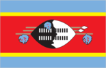
Flag description
three horizontal bands of blue (top), red (triple width), and blue; the red band is edged in yellow; centered in the red band is a large black and white shield covering two spears and a staff decorated with feather tassels, all placed horizontally; blue stands for peace and stability, red represents past struggles, and yellow the mineral resources of the country; the shield, spears, and staff symbolize protection from the country's enemies, while the black and white of the shield are meant to portray black and white people living in peaceful coexistence
Government type
monarchy
Independence
6 September 1968 (from the UK)
International law organization participation
accepts compulsory ICJ jurisdiction with reservations; non-party state to the ICCt
International organization participation
ACP, AfDB, AU, C, COMESA, FAO, G-77, IAEA, IBRD, ICAO, ICRM, IDA, IFAD, IFC, IFRCS, ILO, IMF, IMO, Interpol, IOC, IOM, ISO (correspondent), ITSO, ITU, ITUC (NGOs), MIGA, NAM, OPCW, PCA, SACU, SADC, UN, UNCTAD, UNESCO, UNIDO, UNWTO, UPU, WCO, WHO, WIPO, WMO, WTO
Judicial branch
- the Supreme Court of the Judicature comprising the Supreme Court (consists of the chief justice and at least 5 justices) and the High Court (consists of the chief justice - ex officio - and at least 4 justices); note - the Supreme Court has jurisdiction in all constitutional matters note - the national constitution as amended in 2006 shifted judicial power from the monarch and vested it exclusively in the judiciary justices of the Supreme Court of the Judicature are appointed by the monarch on the advice of the Judicial Service Commission or JCS, a judicial advisory body consisting of the Supreme Court Chief Justice, 4 members appointed by the monarch, and the JCS head; justices of both courts eligible for retirement at age 65 with mandatory retirement at age 75 for Supreme Court justices and at age 70 for High Court justices magistrates' courts; National Swazi Courts for administering customary/traditional law (jurisdiction restricted to customary law for Swazi citizens)
- highest court(s)
- the Supreme Court of the Judicature comprising the Supreme Court (consists of the chief justice and at least 5 justices) and the High Court (consists of the chief justice - ex officio - and at least 4 justices); note - the Supreme Court has jurisdiction in all constitutional matters
- judge selection and term of office
- justices of the Supreme Court of the Judicature are appointed by the monarch on the advice of the Judicial Service Commission or JCS, a judicial advisory body consisting of the Supreme Court Chief Justice, 4 members appointed by the monarch, and the JCS head; justices of both courts eligible for retirement at age 65 with mandatory retirement at age 75 for Supreme Court justices and at age 70 for High Court justices
- subordinate courts
- magistrates' courts; National Swazi Courts for administering customary/traditional law (jurisdiction restricted to customary law for Swazi citizens)
Legal system
mixed legal system of civil, common, and customary law
Legislative branch
- bicameral Parliament or Libandla consists of the Senate (30 seats; 10 members elected by the House of Assembly and 20 appointed by the monarch; members to serve five-year terms) and the House of Assembly (65 seats; 10 members appointed by the monarch and 55 elected by popular vote; members to serve five-year terms) House of Assembly - last held on 19 September 2008 (next to be held on 20 September 2013) House of Assembly - balloting is done on a nonparty basis; candidates for election nominated by the local council of each constituency and for each constituency the three candidates with the most votes in the first round of voting are narrowed to a single winner by a second round
- election results
- House of Assembly - balloting is done on a nonparty basis; candidates for election nominated by the local council of each constituency and for each constituency the three candidates with the most votes in the first round of voting are narrowed to a single winner by a second round
- elections
- House of Assembly - last held on 19 September 2008 (next to be held on 20 September 2013)
National anthem
- "Nkulunkulu Mnikati wetibusiso temaSwati" (Oh God, Bestower of the Blessings of the Swazi) Andrease Enoke Fanyana SIMELANE/David Kenneth RYCROFT adopted 1968; the anthem uses elements of both ethnic Swazi and Western music styles
- lyrics/music
- Andrease Enoke Fanyana SIMELANE/David Kenneth RYCROFT
- name
- "Nkulunkulu Mnikati wetibusiso temaSwati" (Oh God, Bestower of the Blessings of the Swazi)
National holiday
Independence Day, 6 September (1968)
National symbol(s)
lion; elephant
Political parties and leaders
the status of political parties, previously banned, is unclear under the 2006 Constitution and currently being debated; the following are considered political associations African United Democratic Party or AUDP [Stanley MAUNDZISA, president] Imbokodvo National Movement or INM Ngwane National Liberatory Congress or NNLC [Obed DLAMINI, president] People's United Democratic Movement or PUDEMO [Mario MASUKU, president]
Political pressure groups and leaders
Swaziland Democracy Campaign Swaziland Federation of Trade Unions Swaziland Solidarity Network or SSN
Suffrage
18 years of age
Economy
Agriculture - products
sugarcane, cotton, corn, tobacco, rice, citrus, pineapples, sorghum, peanuts; cattle, goats, sheep
Budget
- $1.451 billion $1.438 billion (2012 est.)
- expenditures
- $1.438 billion (2012 est.)
- revenues
- $1.451 billion
Budget surplus (+) or deficit (-)
0.3% of GDP (2012 est.)
Central bank discount rate
6.5% (31 December 2010 est.) 6.5% (31 December 2009 est.)
Commercial bank prime lending rate
8.75% (31 December 2012 est.) 9% (31 December 2011 est.)
Current account balance
$53 million (2012 est.) $-201 million (2011 est.)
Debt - external
$604.8 million (31 December 2012 est.) $604.5 million (31 December 2011 est.)
Distribution of family income - Gini index
50.4 (2001)
Economy - overview
Surrounded by South Africa, except for a short border with Mozambique, Swaziland depends heavily on South Africa from which it receives more than 90% of its imports and to which it sends 60% of its exports. Swaziland's currency is pegged to the South African rand, effectively subsuming Swaziland's monetary policy to South Africa. The government is heavily dependent on customs duties from the Southern African Customs Union (SACU), and worker remittances from South Africa supplement domestically earned income. Subsistence agriculture employs approximately 70% of the population. The manufacturing sector has diversified since the mid-1980s. Sugar and wood pulp were major foreign exchange earners; however, the wood pulp producer closed in January 2010, and sugar is now the main export earner. Mining has declined in importance in recent years with only coal and quarry stone mines remaining active. Customs revenues plummeted due to the global economic crisis and a drop in South African imports. The resulting decline in revenue has pushed the country into a fiscal crisis. Swaziland is looking to other countries, including South Africa, for assistance, but continues to struggle to meet its monthly payroll and fund government programs. With an estimated 40% unemployment rate, Swaziland''s need to increase the number and size of small and medium enterprises and attract foreign direct investment is acute. Overgrazing, soil depletion, drought, and floods persist as problems for the future. More than one-fourth of the population needed emergency food aid in 2006-07 because of drought, and more than one-quarter of the adult population has been infected by HIV/AIDS.
Exchange rates
emalangeni per US dollar - 8.2 (2012 est.) 7.26 (2011 est.) 7.32 (2010 est.) 8.42 (2009) 7.75 (2008)
Exports
$1.681 billion (2012 est.) $1.906 billion (2011 est.)
Exports - commodities
soft drink concentrates, sugar, wood pulp, cotton yarn, refrigerators, citrus and canned fruit
Fiscal year
1 April - 31 March
GDP - composition, by end use
- 79.9% 20% 11.9% 0% 59.3% -71.2% (2012 est.)
- exports of goods and services
- 59.3%
- government consumption
- 20%
- household consumption
- 79.9%
- imports of goods and services
- -71.2%
- investment in fixed capital
- 11.9%
- investment in inventories
- 0%
GDP - composition, by sector of origin
- 7.5% 47.9% 44.6% (2012 est.)
- agriculture
- 7.5%
- industry
- 47.9%
- services
- 44.6% (2012 est.)
GDP - per capita (PPP)
$5,700 (2012 est.) $5,900 (2011 est.) $5,900 (2010 est.) data are in 2012 US dollars
GDP - real growth rate
-1.5% (2012 est.) 0.3% (2011 est.) 1.9% (2010 est.)
GDP (official exchange rate)
$3.7 billion (2012 est.)
GDP (purchasing power parity)
$6.174 billion (2012 est.) $6.268 billion (2011 est.) $6.251 billion (2010 est.) data are in 2012 US dollars
Gross national saving
13.4% of GDP (2012 est.) 4.5% of GDP (2011 est.) -0.3% of GDP (2010 est.)
Household income or consumption by percentage share
- 1.7% 40.1% (2010 est.)
- highest 10%
- 40.1% (2010 est.)
- lowest 10%
- 1.7%
Imports
$1.578 billion (2012 est.) $1.95 billion (2011 est.)
Imports - commodities
motor vehicles, machinery, transport equipment, foodstuffs, petroleum products, chemicals
Industrial production growth rate
-1.1% (2012 est.)
Industries
coal, wood pulp, sugar, soft drink concentrates, textiles and apparel
Inflation rate (consumer prices)
8.9% (2012 est.) 6.1% (2011 est.)
Labor force
424,100 (2011 est.)
Labor force - by occupation
- 70% NA% NA%
- agriculture
- 70%
- industry
- NA%
- services
- NA%
Market value of publicly traded shares
$203.1 million (31 December 2007) $200 million (31 December 2006)
Population below poverty line
69% (2006)
Reserves of foreign exchange and gold
$741 million (31 December 2012 est.) $600.5 million (31 December 2011 est.)
Stock of broad money
$1.106 billion (31 December 2012 est.) $1.087 billion (31 December 2011 est.)
Stock of direct foreign investment - abroad
$NA
Stock of direct foreign investment - at home
$NA
Stock of domestic credit
$762.9 million (31 December 2012 est.) $948.6 million (31 December 2011 est.)
Stock of narrow money
$403.3 million (31 December 2012 est.) $355.1 million (31 December 2011 est.)
Taxes and other revenues
39.2% of GDP (2012 est.)
Unemployment rate
40% (2006 est.)
Energy
Carbon dioxide emissions from consumption of energy
1.024 million Mt (2011 est.)
Crude oil - exports
0 bbl/day (2010 est.)
Crude oil - imports
0 bbl/day (2010 est.)
Crude oil - production
0 bbl/day (2012 est.)
Crude oil - proved reserves
0 bbl (1 January 2010 es)
Electricity - consumption
1.058 billion kWh (2010 est.)
Electricity - exports
0 kWh (2012)
Electricity - from fossil fuels
59.7% of total installed capacity (2010 est.)
Electricity - from hydroelectric plants
40.3% of total installed capacity (2010 est.)
Electricity - from nuclear fuels
0% of total installed capacity (2010 est.)
Electricity - from other renewable sources
0% of total installed capacity (2010 est.)
Electricity - imports
564 million kWh (2011 est.)
Electricity - installed generating capacity
149,000 kW (2010 est.)
Electricity - production
496 million kWh (2010 est.)
Natural gas - consumption
0 cu m (2010 est.)
Natural gas - exports
0 cu m (2011 est.)
Natural gas - imports
0 cu m (2011 est.)
Natural gas - production
0 cu m (2011 est.)
Natural gas - proved reserves
0 cu m (1 January 2013 es)
Refined petroleum products - consumption
4,567 bbl/day (2011 est.)
Refined petroleum products - exports
0 bbl/day (2010 est.)
Refined petroleum products - imports
4,761 bbl/day (2010 est.)
Refined petroleum products - production
0 bbl/day (2010 est.)
Communications
Broadcast media
state-owned TV station; satellite dishes are able to access South African providers; state-owned radio network with 3 channels; 1 private radio station (2007)
Internet country code
.sz
Internet hosts
2,744 (2012)
Internet users
90,100 (2009)
Telephone system
- a somewhat modern but not an advanced system single source for mobile-cellular service with a geographic coverage of about 90% and a rising subscribership base; combined fixed-line and mobile cellular teledensity roughly 60 telephones per 100 persons in 2011; telephone system consists of carrier-equipped, open-wire lines and low-capacity, microwave radio relay country code - 268; satellite earth station - 1 Intelsat (Atlantic Ocean) (2009)
- domestic
- single source for mobile-cellular service with a geographic coverage of about 90% and a rising subscribership base; combined fixed-line and mobile cellular teledensity roughly 60 telephones per 100 persons in 2011; telephone system consists of carrier-equipped, open-wire lines and low-capacity, microwave radio relay
- general assessment
- a somewhat modern but not an advanced system
- international
- country code - 268; satellite earth station - 1 Intelsat (Atlantic Ocean) (2009)
Telephones - main lines in use
48,600 (2012)
Telephones - mobile cellular
805,000 (2012)
Transportation
Airports
14 (2013)
Airports - with paved runways
- 1 (2013)
- 2,438 to 3,047 m
- 1 (2013)
- over 3,047 m
- 1
- total
- 2
Airports - with unpaved runways
- 7 (2013)
- 914 to 1,523 m
- 5
- total
- 12
Railways
- 301 km 301 km 1.067-m gauge (2008)
- total
- 301 km
Roadways
- 3,594 km 1,078 km 2,516 km (2002)
- total
- 3,594 km
- unpaved
- 2,516 km (2002)
Military and Security
Manpower available for military service
- 344,038 (2010 est.)
- males age 16-49
- 344,038 (2010 est.)
Manpower fit for military service
- 201,853 175,477 (2010 est.)
- females age 16-49
- 175,477 (2010 est.)
- males age 16-49
- 201,853
Manpower reaching militarily significant age annually
- 16,168 15,763 (2010 est.)
- female
- 15,763 (2010 est.)
- male
- 16,168
Military branches
- Umbutfo Swaziland Defense Force (USDF): Ground Force (includes Air Wing (no operational aircraft)) (2013)
- Umbutfo Swaziland Defense Force (USDF)
- Ground Force (includes Air Wing (no operational aircraft)) (2013)
Military expenditures
2.6% of GDP (2011)
Military service age and obligation
18-30 years of age for male and female voluntary military service; no conscription; compulsory HIV testing required, only HIV-negative applicants accepted (2012)
Transnational Issues
Disputes - international
in 2006, Swazi king advocated resorting to ICJ to claim parts of Mpumalanga and KwaZulu-Natal from South Africa