2012 Edition
CIA World Factbook 2012 Archive (HTML)
Introduction
Background
The UN awarded Eritrea to Ethiopia in 1952 as part of a federation. Ethiopia's annexation of Eritrea as a province 10 years later sparked a 30-year struggle for independence that ended in 1991 with Eritrean rebels defeating governmental forces; independence was overwhelmingly approved in a 1993 referendum. A two-and-a-half-year border war with Ethiopia that erupted in 1998 ended under UN auspices in December 2000. Eritrea hosted a UN peacekeeping operation that monitored a 25 km-wide Temporary Security Zone (TSZ) on the border with Ethiopia. Eritrea's denial of fuel to the mission caused the UN to withdraw the mission and terminate its mandate 31 July 2008. An international commission, organized to resolve the border dispute, posted its findings in 2002. However, both parties have been unable to reach agreement on implementing the decision. On 30 November 2007, the Eritrea-Ethiopia Boundary Commission remotely demarcated the border by coordinates and dissolved itself, leaving Ethiopia still occupying several tracts of disputed territory, including the town of Badme. Eritrea accepted the EEBC's "virtual demarcation" decision and called on Ethiopia to remove its troops from the TSZ that it states is Eritrean territory. Ethiopia has not accepted the virtual demarcation decision. In 2009 and 2011 the UN passed sanctions resolutions on Eritrea after accusing it of backing anti-Ethiopian Islamist insurgents in Somalia.
Geography
Area
- 117,600 sq km 101,000 sq km 16,600 sq km
- total
- 117,600 sq km
- water
- 16,600 sq km
Area - comparative
slightly larger than Pennsylvania
Climate
hot, dry desert strip along Red Sea coast; cooler and wetter in the central highlands (up to 61 cm of rainfall annually, heaviest June to September); semiarid in western hills and lowlands
Coastline
2,234 km (mainland on Red Sea 1,151 km, islands in Red Sea 1,083 km)
Elevation extremes
- near Kulul within the Danakil Depression -75 m Soira 3,018 m
- highest point
- Soira 3,018 m
- lowest point
- near Kulul within the Danakil Depression -75 m
Environment - current issues
deforestation; desertification; soil erosion; overgrazing; loss of infrastructure from civil warfare
Environment - international agreements
- Biodiversity, Climate Change, Climate Change-Kyoto Protocol, Desertification, Endangered Species, Hazardous Wastes, Ozone Layer Protection none of the selected agreements
- party to
- Biodiversity, Climate Change, Climate Change-Kyoto Protocol, Desertification, Endangered Species, Hazardous Wastes, Ozone Layer Protection
- signed, but not ratified
- none of the selected agreements
Freshwater withdrawal (domestic/industrial/agricultural)
- 0.3 cu km/yr (3%/0%/97%) 68 cu m/yr (2000)
- per capita
- 68 cu m/yr (2000)
- total
- 0.3 cu km/yr (3%/0%/97%)
Geographic coordinates
15 00 N, 39 00 E
Geography - note
strategic geopolitical position along world's busiest shipping lanes; Eritrea retained the entire coastline of Ethiopia along the Red Sea upon de jure independence from Ethiopia on 24 May 1993
Irrigated land
210 sq km (2003)
Land boundaries
- 1,626 km Djibouti 109 km, Ethiopia 912 km, Sudan 605 km
- border countries
- Djibouti 109 km, Ethiopia 912 km, Sudan 605 km
- total
- 1,626 km
Land use
- 4.78% 0.03% 95.19% (2005)
- arable land
- 4.78%
- other
- 95.19% (2005)
- permanent crops
- 0.03%
Location
Eastern Africa, bordering the Red Sea, between Djibouti and Sudan
Map references
Africa
Maritime claims
- 12 nm
- territorial sea
- 12 nm
Natural hazards
- frequent droughts, rare earthquakes and volcanoes; locust swarms Dubbi (elev. 1,625 m), which last erupted in 1861, was the country's only historically active volcano until Nabro (2,218 m) came to life on 12 June 2011
- volcanism
- Dubbi (elev. 1,625 m), which last erupted in 1861, was the country's only historically active volcano until Nabro (2,218 m) came to life on 12 June 2011
Natural resources
gold, potash, zinc, copper, salt, possibly oil and natural gas, fish
Terrain
dominated by extension of Ethiopian north-south trending highlands, descending on the east to a coastal desert plain, on the northwest to hilly terrain and on the southwest to flat-to-rolling plains
Total renewable water resources
6.3 cu km (2001)
People and Society
Age structure
- 41.7% (male 1,275,272/ female 1,262,833) 54.6% (male 1,632,984/ female 1,692,554) 3.7% (male 98,495/ female 124,357) (2012 est.)
- 0-14 years
- 41.7% (male 1,275,272/ female 1,262,833)
- 15-64 years
- 54.6% (male 1,632,984/ female 1,692,554)
- 65 years and over
- 3.7% (male 98,495/ female 124,357) (2012 est.)
Birth rate
32.1 births/1,000 population (2012 est.)
Children under the age of 5 years underweight
34.5% (2002)
Death rate
7.92 deaths/1,000 population (July 2012 est.)
Education expenditures
2% of GDP (2006)
Ethnic groups
- nine recognized ethnic groups: Tigrinya 55%, Tigre 30%, Saho 4%, Kunama 2%, Rashaida 2%, Bilen 2%, other (Afar, Beni Amir, Nera) 5% (2010 est.)
- nine recognized ethnic groups
- Tigrinya 55%, Tigre 30%, Saho 4%, Kunama 2%, Rashaida 2%, Bilen 2%, other (Afar, Beni Amir, Nera) 5% (2010 est.)
Health expenditures
7% of GDP (2009)
HIV/AIDS - adult prevalence rate
0.8% (2009 est.)
HIV/AIDS - deaths
1,700 (2009 est.)
HIV/AIDS - people living with HIV/AIDS
25,000 (2009 est.)
Hospital bed density
1.15 beds/1,000 population (2006)
Infant mortality rate
- 40.34 deaths/1,000 live births 45.69 deaths/1,000 live births 34.82 deaths/1,000 live births (2012 est.)
- female
- 34.82 deaths/1,000 live births (2012 est.)
- total
- 40.34 deaths/1,000 live births
Languages
Tigrinya (official), Arabic (official), English (official), Tigre, Kunama, Afar, other Cushitic languages
Life expectancy at birth
- 62.86 years 60.73 years 65.06 years (2012 est.)
- female
- 65.06 years (2012 est.)
- total population
- 62.86 years
Literacy
- age 15 and over can read and write 67.8% 78.7% 57.5% (2010 est.)
- definition
- age 15 and over can read and write
- female
- 57.5% (2010 est.)
- male
- 78.7%
- total population
- 67.8%
Major cities - population
ASMARA (capital) 649,000 (2009)
Major infectious diseases
- high bacterial diarrhea, hepatitis A, and typhoid fever malaria (2009)
- degree of risk
- high
- food or waterborne diseases
- bacterial diarrhea, hepatitis A, and typhoid fever
- vectorborne disease
- malaria (2009)
Maternal mortality rate
240 deaths/100,000 live births (2010)
Median age
- 18.9 years 18.5 years 19.2 years (2012 est.)
- female
- 19.2 years (2012 est.)
- male
- 18.5 years
- total
- 18.9 years
Nationality
- Eritrean(s) Eritrean
- adjective
- Eritrean
- noun
- Eritrean(s)
Net migration rate
0 migrant(s)/1,000 population (2012 est.)
Obesity - adult prevalence rate
3.3% (2004)
Physicians density
0.05 physicians/1,000 population (2004)
Population
6,086,495 (July 2012 est.)
Population growth rate
2.418% (2012 est.)
Religions
Muslim, Coptic Christian, Roman Catholic, Protestant
Sanitation facility access
- urban: 52% of population rural: 4% of population total: 14% of population urban: 48% of population rural: 96% of population total: 86% of population
- rural
- 96% of population
- total
- 86% of population
- urban
- 48% of population
School life expectancy (primary to tertiary education)
- 5 years 6 years 4 years (2009)
- female
- 4 years (2009)
- male
- 6 years
- total
- 5 years
Sex ratio
- 1.03 male(s)/female 1.01 male(s)/female 0.96 male(s)/female 0.79 male(s)/female 0.98 male(s)/female (2011 est.)
- 15-64 years
- 0.96 male(s)/female
- 65 years and over
- 0.79 male(s)/female
- at birth
- 1.03 male(s)/female
- total population
- 0.98 male(s)/female (2011 est.)
- under 15 years
- 1.01 male(s)/female
Total fertility rate
4.37 children born/woman (2012 est.)
Urbanization
- 22% of total population (2010) 5.2% annual rate of change (2010-15 est.)
- rate of urbanization
- 5.2% annual rate of change (2010-15 est.)
- urban population
- 22% of total population (2010)
Government
Administrative divisions
6 regions (zobatat, singular - zoba); Anseba, Debub (South), Debubawi K'eyih Bahri (Southern Red Sea), Gash Barka, Ma'akel (Central), Semenawi Keyih Bahri (Northern Red Sea)
Capital
- Asmara (Asmera) 15 20 N, 38 56 E UTC+3 (8 hours ahead of Washington, DC during Standard Time)
- geographic coordinates
- 15 20 N, 38 56 E
- name
- Asmara (Asmera)
- time difference
- UTC+3 (8 hours ahead of Washington, DC during Standard Time)
Constitution
adopted 23 May 1997, but has not yet been fully implemented
Country name
- State of Eritrea Eritrea Hagere Ertra Ertra Eritrea Autonomous Region in Ethiopia
- conventional long form
- State of Eritrea
- conventional short form
- Eritrea
- former
- Eritrea Autonomous Region in Ethiopia
- local long form
- Hagere Ertra
- local short form
- Ertra
Diplomatic representation from the US
- Ambassador (vacant); Charge d'Affaires Sue BREMNER 179 Ala Street, Asmara P. O. Box 211, Asmara [291] (1) 120004 [291] (1) 127584
- chief of mission
- Ambassador (vacant); Charge d'Affaires Sue BREMNER
- embassy
- 179 Ala Street, Asmara
- FAX
- [291] (1) 127584
- mailing address
- P. O. Box 211, Asmara
- telephone
- [291] (1) 120004
Diplomatic representation in the US
- Ambassador (vacant); Charge d'Affaires BERHANE Gebrehiwet Solomon 1708 New Hampshire Avenue NW, Washington, DC 20009 [1] (202) 319-1991 [1] (202) 319-1304 Oakland (California)
- chancery
- 1708 New Hampshire Avenue NW, Washington, DC 20009
- chief of mission
- Ambassador (vacant); Charge d'Affaires BERHANE Gebrehiwet Solomon
- consulate(s) general
- Oakland (California)
- FAX
- [1] (202) 319-1304
- telephone
- [1] (202) 319-1991
Executive branch
- President ISAIAS Afworki (since 8 June 1993); note - the president is both the chief of state and head of government and is head of the State Council and National Assembly President ISAIAS Afworki (since 8 June 1993) State Council the collective is executive authority; members appointed by the president president elected by the National Assembly for a five-year term (eligible for a second term); the most recent and only election was held on 8 June 1993 (next election date uncertain as the National Assembly did not hold a presidential election in December 2001 as anticipated) ISAIAS Afworki elected president; percent of National Assembly vote - ISAIAS Afworki 95%, other 5%
- cabinet
- State Council the collective is executive authority; members appointed by the president
- chief of state
- President ISAIAS Afworki (since 8 June 1993); note - the president is both the chief of state and head of government and is head of the State Council and National Assembly
- election results
- ISAIAS Afworki elected president; percent of National Assembly vote - ISAIAS Afworki 95%, other 5%
- elections
- president elected by the National Assembly for a five-year term (eligible for a second term); the most recent and only election was held on 8 June 1993 (next election date uncertain as the National Assembly did not hold a presidential election in December 2001 as anticipated)
- head of government
- President ISAIAS Afworki (since 8 June 1993)
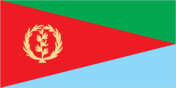
Flag description
red isosceles triangle (based on the hoist side) dividing the flag into two right triangles; the upper triangle is green, the lower one is blue; a gold wreath encircling a gold olive branch is centered on the hoist side of the red triangle; green stands for the country's agriculture economy, red signifies the blood shed in the fight for freedom, and blue symbolizes the bounty of the sea; the wreath-olive branch symbol is similar to that on the first flag of Eritrea from 1952; the shape of the red triangle broadly mimics the shape of the country
Government type
transitional government following a successful referendum on independence for the Autonomous Region of Eritrea on 23-25 April 1993, a National Assembly, composed entirely of the People's Front for Democracy and Justice or PFDJ, was established as a transitional legislature; a Constitutional Commission was also established to draft a constitution; ISAIAS Afworki was elected president by the transitional legislature; the constitution, ratified in May 1997, did not enter into effect, pending parliamentary and presidential elections; parliamentary elections were scheduled in December 2001 but were postponed indefinitely; currently the sole legal party is the People's Front for Democracy and Justice
Independence
24 May 1993 (from Ethiopia)
International law organization participation
has not submitted an ICJ jurisdiction declaration; non-party state to the ICCt
International organization participation
ACP, AfDB, AU, COMESA, FAO, G-77, IAEA, IBRD, ICAO, ICC (NGOs), IDA, IFAD, IFC, IFRCS (observer), ILO, IMF, IMO, Interpol, IOC, ISO (subscriber), ITU, ITUC (NGOs), LAS (observer), MIGA, NAM, OPCW, PCA, UN, UNCTAD, UNESCO, UNIDO, UNWTO, UPU, WCO, WFTU (NGOs), WHO, WIPO, WMO
Judicial branch
Supreme Court; Regional, subregional, and village courts
Legal system
mixed legal system of civil, customary, and Islamic religious law
Legislative branch
- unicameral National Assembly (150 seats; members elected by direct popular vote to serve five-year terms) in May 1997, following the adoption of the new constitution, 75 members of the PFDJ Central Committee (the old Central Committee of the EPLF), 60 members of the 527-member Constituent Assembly, which had been established in 1997 to discuss and ratify the new constitution, and 15 representatives of Eritreans living abroad were formed into a Transitional National Assembly to serve as the country's legislative body until countrywide elections to a National Assembly were held; although only 75 of 150 members of the Transitional National Assembly were elected, the constitution stipulates that once past the transition stage, all members of the National Assembly will be elected by secret ballot of all eligible voters; National Assembly elections scheduled for December 2001 were postponed indefinitely
- elections
- in May 1997, following the adoption of the new constitution, 75 members of the PFDJ Central Committee (the old Central Committee of the EPLF), 60 members of the 527-member Constituent Assembly, which had been established in 1997 to discuss and ratify the new constitution, and 15 representatives of Eritreans living abroad were formed into a Transitional National Assembly to serve as the country's legislative body until countrywide elections to a National Assembly were held; although only 75 of 150 members of the Transitional National Assembly were elected, the constitution stipulates that once past the transition stage, all members of the National Assembly will be elected by secret ballot of all eligible voters; National Assembly elections scheduled for December 2001 were postponed indefinitely
National anthem
- "Ertra, Ertra, Ertra" (Eritrea, Eritrea, Eritrea) SOLOMON Tsehaye Beraki/Isaac Abraham MEHAREZGI and ARON Tekle Tesfatsion adopted 1993; upon independence from Ethiopia in 1993, Eritrea adopted its own national anthem
- lyrics/music
- SOLOMON Tsehaye Beraki/Isaac Abraham MEHAREZGI and ARON Tekle Tesfatsion
- name
- "Ertra, Ertra, Ertra" (Eritrea, Eritrea, Eritrea)
National holiday
Independence Day, 24 May (1993)
National symbol(s)
camel
Political parties and leaders
People's Front for Democracy and Justice or PFDJ [ISAIAS Afworki] (the only party recognized by the government); note - a National Assembly committee drafted a law on political parties in January 2001, but the full National Assembly has yet to debate or vote on it
Political pressure groups and leaders
Democratic Movement for the Liberation of Eritrean Kunama (DMLEK); Eritrean Democratic Alliance (EDA) [TEWELDE Ghebreselasie]; Eritrean National Congress for Democratic Change (ENCDC) [YUSEF Berhanu]; Eritrean National Salvation Front (ENSF) [AHMAD Nasser]; Eritrean Islamic Party for Justice and Development (EIPJD) (includes the Eritrean Islamic Jihad (EIJ), Eritrean Islamic Jihad Movement (EIJM), Eritrean Islamic Salvation, and the Eritrean Islamic Foundation); Eritrean People's Democratic Party (EPDF); Red Sea Afar Democratic Organization (RSADO)
Suffrage
18 years of age; universal
Economy
Agriculture - products
sorghum, lentils, vegetables, corn, cotton, tobacco, sisal; livestock, goats; fish
Budget
- $838.8 million $1.19 billion (2012 est.)
- expenditures
- $1.19 billion (2012 est.)
- revenues
- $838.8 million
Budget surplus (+) or deficit (-)
-11.3% of GDP (2012 est.)
Commercial bank prime lending rate
NA%
Current account balance
-$271.5 million (2012 est.) -$127.8 million (2011 est.)
Debt - external
$1.026 billion (31 December 2012 est.) $1.013 billion (31 December 2011 est.)
Economy - overview
Since independence from Ethiopia in 1993, Eritrea has faced the economic problems of a small, desperately poor country, accentuated by the recent implementation of restrictive economic policies. Eritrea has a command economy under the control of the sole political party, the People's Front for Democracy and Justice (PFDJ). Like the economies of many African nations, a large share of the population - nearly 80% - is engaged in subsistence agriculture, but they produce only a small share of total output. Since the conclusion of the Ethiopian-Eritrea war in 2000, the government has maintained a firm grip on the economy, expanding the use of the military and party-owned businesses to complete Eritrea's development agenda. The government strictly controls the use of foreign currency by limiting access and availability. Few private enterprises remain in Eritrea. Eritrea's economy depends heavily on taxes paid by members of the diaspora. Erratic rainfall and the delayed demobilization of agriculturalists from the military continue to interfere with agricultural production, and Eritrea's recent harvests have been unable to meet the food needs of the country. Eritrea's development of copper and gold production through Canadian mining companies will drive Eritrea's economic growth over the next few years. The government is likely to continue diverting resources to its military instead of wide-scale economic development or investment plans. Eritrea's economic future depends upon its ability to master social problems such as illiteracy, unemployment, and low skills, and more importantly, on the government's willingness to support a true market economy.
Exchange rates
nakfa (ERN) per US dollar - 15.38 (2012 est.) 15.375 (2011 est.) 15.375 (2010 est.) 15.375 (2009) 15.38 (2008)
Exports
$304.5 million (2012 est.) $415.4 million (2011 est.)
Exports - commodities
livestock, sorghum, textiles, food, small manufactures
Fiscal year
calendar year
GDP - composition by sector
- 11.6% 30.6% 57.8% (2012 est.)
- agriculture
- 11.6%
- industry
- 30.6%
- services
- 57.8% (2012 est.)
GDP - per capita (PPP)
$800 (2012 est.) $700 (2011 est.) $700 (2010 est.) data are in 2012 US dollars
GDP - real growth rate
7.5% (2012 est.) 8.7% (2011 est.) 2.2% (2010 est.)
GDP (official exchange rate)
$3.108 billion (2012 est.)
GDP (purchasing power parity)
$4.412 billion (2012 est.) $4.103 billion (2011 est.) $3.774 billion (2010 est.) data are in 2012 US dollars
Household income or consumption by percentage share
- NA% NA%
- highest 10%
- NA%
- lowest 10%
- NA%
Imports
$939.7 million (2012 est.) $899.9 million (2011 est.)
Imports - commodities
machinery, petroleum products, food, manufactured goods
Industrial production growth rate
8% (2010 est.)
Inflation rate (consumer prices)
17% (2012 est.) 20% (2011 est.)
Investment (gross fixed)
27.5% of GDP (2012 est.)
Labor force
1.935 million (2007)
Labor force - by occupation
- 80% 20% (2004 est.)
- agriculture
- 80%
- industry and services
- 20% (2004 est.)
Population below poverty line
50% (2004 est.)
Public debt
118% of GDP (2012 est.) 118.5% of GDP (2011 est.)
Reserves of foreign exchange and gold
$171.2 million (31 December 2012 est.) $114.8 million (31 December 2011 est.)
Stock of broad money
$3.889 billion (31 December 2012 est.) $3.156 billion (31 December 2011 est.)
Stock of domestic credit
$3.947 billion (31 December 2012 est.) $3.2 billion (31 December 2011 est.)
Stock of narrow money
$1.817 billion (31 December 2012 est.) $1.471 billion (31 December 2011 est.)
Taxes and other revenues
27% of GDP (2012 est.)
Unemployment rate
NA%
Energy
Carbon dioxide emissions from consumption of energy
798,200 Mt (2010 est.)
Crude oil - exports
0 bbl/day (2009 est.)
Crude oil - imports
0 bbl/day (2009 est.)
Crude oil - production
0 bbl/day (2011 est.)
Crude oil - proved reserves
0 bbl (1 January 2012 est.)
Electricity - consumption
242 million kWh (2009 est.)
Electricity - exports
0 kWh (2010 est.)
Electricity - from fossil fuels
99.3% of total installed capacity (2009 est.)
Electricity - from hydroelectric plants
0% of total installed capacity (2009 est.)
Electricity - from nuclear fuels
0% of total installed capacity (2009 est.)
Electricity - from other renewable sources
0.7% of total installed capacity (2009 est.)
Electricity - imports
0 kWh (2010 est.)
Electricity - installed generating capacity
139,000 kW (2009 est.)
Electricity - production
277 million kWh (2009 est.)
Natural gas - consumption
0 cu m (2010 est.)
Natural gas - exports
0 cu m (2010 est.)
Natural gas - imports
0 cu m (2010 est.)
Natural gas - production
0 cu m (2010 est.)
Natural gas - proved reserves
0 cu m (1 January 2012 est.)
Refined petroleum products - consumption
4,480 bbl/day (2011 est.)
Refined petroleum products - exports
0 bbl/day (2008 est.)
Refined petroleum products - imports
2,670 bbl/day (2008 est.)
Refined petroleum products - production
0 bbl/day (2008 est.)
Communications
Broadcast media
government controls broadcast media with private ownership prohibited; 1 state-owned TV station; state-owned radio operates 2 networks; purchases of satellite dishes and subscriptions to international broadcast media are permitted (2007)
Internet country code
.er
Internet hosts
701 (2012)
Internet users
200,000 (2008)
Telephone system
- inadequate; most telephones are in Asmara; government is seeking international tenders to improve the system combined fixed-line and mobile-cellular subscribership is less than 5 per 100 persons country code - 291; note - international connections exist
- domestic
- combined fixed-line and mobile-cellular subscribership is less than 5 per 100 persons
- general assessment
- inadequate; most telephones are in Asmara; government is seeking international tenders to improve the system
- international
- country code - 291; note - international connections exist
Telephones - main lines in use
58,500 (2011)
Telephones - mobile cellular
241,900 (2011)
Transportation
Airports
13 (2012)
Airports - with paved runways
- 2 (2012)
- 2,438 to 3,047 m
- 2 (2012)
- over 3,047 m
- 2
- total
- 4
Airports - with unpaved runways
- 2 (2012)
- 1,524 to 2,437 m
- 5
- 2,438 to 3,047 m
- 1
- 914 to 1,523 m
- 2 (2012)
- over 3,047 m
- 1
- total
- 9
Heliports
1 (2012)
Merchant marine
- cargo 2, petroleum tanker 1, roll on/roll off 1 (2010)
- total
- 4
Ports and terminals
Assab, Massawa
Railways
- 306 km 306 km 0.950-m gauge (2008)
- total
- 306 km
Roadways
- 4,010 km 874 km 3,136 km (2000)
- total
- 4,010 km
- unpaved
- 3,136 km (2000)
Military and Security
Manpower available for military service
- 1,350,446 1,362,575 (2010 est.)
- females age 16-49
- 1,362,575 (2010 est.)
- males age 16-49
- 1,350,446
Manpower fit for military service
- 896,096 953,757 (2010 est.)
- females age 16-49
- 953,757 (2010 est.)
- males age 16-49
- 896,096
Manpower reaching militarily significant age annually
- 66,829 66,731 (2010 est.)
- female
- 66,731 (2010 est.)
- male
- 66,829
Military branches
- Eritrean Armed Forces: Eritrean Ground Forces, Eritrean Navy, Eritrean Air Force (includes Air Defense Force) (2011)
- Eritrean Armed Forces
- Eritrean Ground Forces, Eritrean Navy, Eritrean Air Force (includes Air Defense Force) (2011)
Military expenditures
6.3% of GDP (2006 est.)
Military service age and obligation
18-40 years of age for male and female voluntary and compulsory military service; 16-month conscript service obligation (2006)
Transnational Issues
Disputes - international
Eritrea and Ethiopia agreed to abide by 2002 Ethiopia-Eritrea Boundary Commission's (EEBC) delimitation decision but, neither party responded to the revised line detailed in the November 2006 EEBC Demarcation Statement; Sudan accuses Eritrea of supporting eastern Sudanese rebel groups; in 2008 Eritrean troops moved across the border on Ras Doumera peninsula and occupied Doumera Island with undefined sovereignty in the Red Sea
Refugees and internally displaced persons
- 3,773 (Somalia) (2012) 10,000 (border war with Ethiopia from 1998-2000; it has not been possible to confirm whether whether remaining IDPs are still living with hosts or have been returned or resettled) (2009)
- IDPs
- 10,000 (border war with Ethiopia from 1998-2000; it has not been possible to confirm whether whether remaining IDPs are still living with hosts or have been returned or resettled) (2009)
- refugees (country of origin)
- 3,773 (Somalia) (2012)
Trafficking in persons
- Eritrea is a source country for men, women, and children trafficked for the purposes of forced labor and commercial sexual exploitation; each year, large numbers of migrant workers depart Eritrea in search of work, particularly in the Gulf States, where some are likely to become victims of forced labor, including in domestic servitude, or commercial sexual exploitation; Eritrean children also work in various economic sectors, including domestic service, street vending, small-scale factories, and agriculture; child laborers frequently suffer abuse from their employers and some may be subjected to conditions of forced labor Tier 3 - the Government of Eritrea does not fully comply with the minimum standards for the elimination of trafficking and is not making significant efforts to do so; the Eritrean Government does not operate with transparency and published neither data nor statistics regarding its efforts to combat human trafficking; the government made no known progress in prosecuting and punishing trafficking crimes over the reporting period and did not appear to provide any significant assistance to victims of trafficking (2009)
- current situation
- Eritrea is a source country for men, women, and children trafficked for the purposes of forced labor and commercial sexual exploitation; each year, large numbers of migrant workers depart Eritrea in search of work, particularly in the Gulf States, where some are likely to become victims of forced labor, including in domestic servitude, or commercial sexual exploitation; Eritrean children also work in various economic sectors, including domestic service, street vending, small-scale factories, and agriculture; child laborers frequently suffer abuse from their employers and some may be subjected to conditions of forced labor
- tier rating
- Tier 3 - the Government of Eritrea does not fully comply with the minimum standards for the elimination of trafficking and is not making significant efforts to do so; the Eritrean Government does not operate with transparency and published neither data nor statistics regarding its efforts to combat human trafficking; the government made no known progress in prosecuting and punishing trafficking crimes over the reporting period and did not appear to provide any significant assistance to victims of trafficking (2009)