1993 Edition
CIA World Factbook 1993 (Project Gutenberg)
Geography
Area
total area: 121,320 km2 land area: 121,320 km2 comparative area: slightly larger than Pennsylvania
Climate
hot, dry desert strip along Red Sea coast; cooler and wetter in the central highlands (up to 61 cm of rainfall annually); semiarid in western hills and lowlands; rainfall heaviest during June-September except on coast desert
Coastline
1,151 km (land and island coastline is 2,234 km)
Environment
frequent droughts, famine; deforestation; soil eroision; overgrazing; loss of infrastructure from civil warfare
International disputes
none
Irrigated land
NA km2
Land boundaries
total 1,630 km, Djibouti 113 km, Ethiopia 912 km, Sudan 605 km
Land use
arable land: 3% permanent crops: 2% (coffee) meadows and pastures: 40% forest and woodland: 5% other: 50%
Location
Eastern Africa, bordering the Red Sea between Djibouti and Sudan
Map references
Africa, Standard Time Zones of the World
Maritime claims
territorial sea: 12 nm
Natural resources
gold, potash, zinc, copper, salt, probably oil, fish
Note
strategic geopolitical position along world's busiest shipping lanes and close to Arabian oilfields, Eritrea retained the entire coastline of Ethiopia along the Red Sea upon de jure independence from Ethiopia on 27 April 1993
Terrain
dominated by extension of Ethiopian north-south trending highlands, descending on the east to a coastal desert plan, on the northwest to hilly terrain and on the southwest to flat-to-rolling plains
People and Society
Birth rate
NA births/1,000 population
Death rate
NA deaths/1,000 population
Ethnic divisions
ethnic Tigrays 50%, Tigre and Kunama 40%, Afar 4%, Saho (Red Sea coast dwellers) 3%
Infant mortality rate
NA deaths/1,000 live births
Labor force
NA
Languages
Tigre and Kunama, Cushitic dialects, Tigre, Nora Bana, Arabic
Life expectancy at birth
total population: NA years male: NA years female: NA years
Literacy
NA%
Nationality
noun: Eritrean(s) adjective: Eritrean
Net migration rate
NA migrant(s)/1,000 population
Population
3,467,087 (July 1993 est.)
Population growth rate
3.46% (1993 est.)
Religions
Muslim, Coptic Christian, Roman Catholic, Protestant
Total fertility rate
NA children born/woman
Government
Administrative divisions
NA
Capital
Asmara (formerly Asmera)
Constitution
transitional "constitution" decreed 19 May 1993
Digraph
ER
Diplomatic representation in US
chief of mission: NA chancery: NA telephone: NA
Elections
multinational election before 20 May 1997
Executive branch
president, Eritrean National Council
FAX
NA
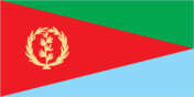
Flag
red isosceles triangle (based on the hoist side) dividing the flag into two right triangles; the upper triangle is green, the lower one is blue; a gold wreath encircling a gold olive branch is centered on the hoist side of the red triangle
Independence
27 April 1993 (from Ethiopia; formerly the Eritrea Autonomous Region)
Judicial branch
Judiciary
Leaders
Chief of State and Head of Government: President ISSAIAS Aferworke
Legal system
NA
Legislative branch
National Assembly
Member of
OAU, UN, UNCTAD
Names
conventional long form: none conventional short form: Eritrea local long form: none local short form: none former: Eritrea Autonomous Region in Ethiopia
National holiday
National Day (independence from Ethiopia), 24 May (1993)
Other political or pressure groups
Oromo Liberation Front (OLF); Ethiopian People's Revolutionary Party (EPRP); numerous small, ethnic-based groups have formed since Mengistu's resignation, including several Islamic militant groups
Political parties and leaders
Eritrean People's Liberation Front (EPLF) (Christian Muslim), ISSAIAS Aferworke, PETROS Soloman; Eritrean Liberation Front (ELF) (Muslim), ABDULLAH Muhammed; Eritrean Liberation Front - United Organization (ELF-UO), leader NA
Suffrage
NA
Type
transitional government note: on 29 May 1991 ISSAIAS Afeworke, secretary general of the Eritrean People's Liberation Front (EPLF), announced the formation of the Provisional Government in Eritrea (PGE), in preparation for the 23-25 April 1993 referendum on independence for the autonomous region of Eritrea; the result was a landslide vote for independence that was announced on 27 April 1993
US diplomatic representation
chief of mission: Joseph P. O'NEILL embassy: NA mailing address: NA telephone: 251-4-113-720
Economy
Agriculture
NA
Budget
revenues $NA; expenditures $NA, including capital expenditures of $NA
Currency
NA
Economic aid
NA
Electricity
NA kW capacity; NA kWh produced, NA kWh per capita
Exchange rates
NA
Exports
$NA commodities: NA partners: NA
External debt
$NA
Fiscal year
NA
Imports
$NA commodities: NA partners: NA
Industrial production
growth rate NA%
Industries
food processing, beverages, clothing and textiles
Inflation rate (consumer prices)
NA%
National product
GDP - exchange rate conversion - $400 million (1992 est.)
National product per capita
$115 (1992 est.)
National product real growth rate
NA%
Overview
With independence from Ethiopia on 27 April 1993, Eritrea faces the bitter economic problems of a small, desperately poor African country. Most of the population will continue to depend on subsistence farming. Domestic output is substantially augmented by worker remittances from abroad. Government revenues come from custom duties and income and sales taxes. Eritrea has inherited the entire coastline of Ethiopia and has long-term prospects for revenues from the devlopment of offshore oil, offshore fishing and tourist development. For the time being, Ethiopia will be largely dependent on Eritrean ports for its foreign trade.
Unemployment rate
NA%
Communications
Airports
total: 5 usable: 5 with permanent-surface runways: 2 with runways over 3,659 m: with runways 2,440-3,659 m: 2 with runways 1,220-2,439 m: 2
Highways
3,845 km total; 807 km paved, 840 km gravel, 402 km improved earth, 1,796 km unimproved earth
Merchant marine
14 ships (1,000 GRT or over) totaling 71,837 GRT/90,492 DWT; includes 9 cargo, 1 roll-on/roll off, 1 livestock carrier, 2 oil tanker, 1 refrigerated cargo
Ports
Assab (formerly Aseb), Massawa (formerly Mits'iwa)
Railroads
307 km total; 307 km 1.000-meter gauge; 307 km 0.950-meter gauge (nonoperational) linking Ak'ordat and Asmera with the port of Mits'iwe (1993 est.)
Telecommunications
NA
Military and Security
Branches
Eritrean People's Liberation Front (EPLF)
Defense expenditures
exchange rate conversion - $NA, NA% of GDP
Manpower availability
males age 15-49 NA; fit for military service NA; reach military age (18) annually NA