1996 Edition
CIA World Factbook 1996 (Project Gutenberg)
Introduction
Description
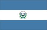
three equal horizontal bands of blue (top), white, and blue with the national coat of arms centered in the white band; the coat of arms features a round emblem encircled by the words REPUBLICA DE EL SALVADOR EN LA AMERICA CENTRAL; similar to the flag of Nicaragua, which has a different coat of arms centered in the white band - it features a triangle encircled by the words REPUBLICA DE NICARAGUA on top and AMERICA CENTRAL on the bottom; also similar to the flag of Honduras, which has five blue stars arranged in an X pattern centered in the white band
Location
13 50 N, 88 55 W -- Middle America, bordering the North Pacific Ocean, between Guatemala and Honduras Flag ----
Geography
Area
- comparative area
- slightly smaller than Massachusetts
- land area
- 20,720 sq km
- total area
- 21,040 sq km
Climate
tropical; rainy season (May to October); dry season (November to April)
Coastline
307 km
Environment
- current issues
- deforestation; soil erosion; water pollution; contamination of soils from disposal of toxic wastes
- international agreements
- party to - Biodiversity, Climate Change, Endangered Species, Hazardous Wastes, Nuclear Test Ban, Ozone Layer Protection; signed, but not ratified - Law of the Sea
- natural hazards
- known as the Land of Volcanoes; frequent and sometimes very destructive earthquakes and volcanic activity
Geographic coordinates
13 50 N, 88 55 W
Geographic note
smallest Central American country and only one without a coastline on Caribbean Sea
International disputes
land boundary dispute with Honduras mostly resolved by 11 September 1992 International Court of Justice (ICJ) decision; with respect to the maritime boundary in the Golfo de Fonseca, ICJ referred to an earlier agreement in this century and advised that some tripartite resolution among El Salvador, Honduras and Nicaragua likely would be required
Irrigated land
1,200 sq km (1989)
Land boundaries
- border countries
- Guatemala 203 km, Honduras 342 km
- total
- 545 km
Land use
- arable land
- 27%
- forest and woodland
- 6%
- meadows and pastures
- 29%
- other
- 30%
- permanent crops
- 8%
Location
Middle America, bordering the North Pacific Ocean, between Guatemala and Honduras
Map references
Central America and the Caribbean
Maritime claims
- territorial sea
- 200 nm
Natural resources
hydropower, geothermal power, petroleum
Terrain
- mostly mountains with narrow coastal belt and central plateau
- highest point
- Cerro El Pital 2,730 m
- lowest point
- Pacific Ocean 0 m
People and Society
Age structure
0-14 years: 38% (male 1,137,804; female 1,097,774) 15-64 years: 57% (male 1,627,519; female 1,716,261) 65 years and over: 5% (male 115,973; female 133,656) (July 1996 est.)
Birth rate
28.3 births/1,000 population (1996 est.)
Death rate
5.81 deaths/1,000 population (1996 est.)
Ethnic divisions
mestizo 94%, Indian 5%, white 1%
Infant mortality rate
31.9 deaths/1,000 live births (1996 est.)
Languages
Spanish, Nahua (among some Indians)
Life expectancy at birth
- female
- 72.5 years (1996 est.)
- male
- 65.44 years
- total population
- 68.88 years
Literacy
- age 15 and over can read and write (1995 est.)
- female
- 69.8%
- male
- 73.5%
- total population
- 71.5%
Nationality
- adjective
- Salvadoran
- noun
- Salvadoran(s)
Net migration rate
-4.4 migrant(s)/1,000 population (1996 est.)
Population
5,828,987 (July 1996 est.)
Population growth rate
1.81% (1996 est.)
Religions
- Roman Catholic 75%
- note
- there is extensive activity by Protestant groups throughout the country; by the end of 1992, there were an estimated 1 million Protestant evangelicals in El Salvador
Sex ratio
- all ages
- 0.98 male(s)/female (1996 est.)
- at birth
- 1.05 male(s)/female
- under 15 years
- 1.04 male(s)/female 15-64 years: 0.95 male(s)/female 65 years and over: 0.87 male(s)/female
Total fertility rate
3.2 children born/woman (1996 est.)
Government
Administrative divisions
14 departments (departamentos, singular - departamento); Ahuachapan, Cabanas, Chalatenango, Cuscatlan, La Libertad, La Paz, La Union, Morazan, San Miguel, San Salvador, Santa Ana, San Vicente, Sonsonate, Usulutan
Capital
San Salvador
Constitution
20 December 1983
Data code
ES
Diplomatic representation in US
- chancery
- 2308 California Street NW, Washington, DC 20008
- chief of mission
- Ambassador Ana Cristina SOL
- consulate(s) general
- Chicago, Dallas, Houston, Los Angeles, Miami, New Orleans, New York, and San Francisco
- telephone
- [1] (202) 265-9671, 9672
Executive branch
- cabinet
- Council of Ministers
- chief of state and head of government
- President Armando CALDERON Sol (since 1 June 1994) and Vice President Enrique BORGO Bustamante (since 1 June 1994) were elected for five-year terms by universal suffrage; election last held 20 March 1994 (next to be held NA March 1999); results - Armando CALDERON SOL (ARENA) 49.03%, Ruben ZAMORA Rivas (CD/FMLN/MNR) 24.09%, Fidel CHAVEZ Mena (PDC) 16.39%, other 10.49%; because no candidate received a majority, a run-off election was held 24 April 1994; results - Armando CALDERON SOL (ARENA) 68.35%, Ruben ZAMORA Rivas (CD/FMLN/MNR) 31.65%
FAX
[503] 278-6011
Flag
three equal horizontal bands of blue (top), white, and blue with the national coat of arms centered in the white band; the coat of arms features a round emblem encircled by the words REPUBLICA DE EL SALVADOR EN LA AMERICA CENTRAL; similar to the flag of Nicaragua, which has a different coat of arms centered in the white band - it features a triangle encircled by the words REPUBLICA DE NICARAGUA on top and AMERICA CENTRAL on the bottom; also similar to the flag of Honduras, which has five blue stars arranged in an X pattern centered in the white band
Independence
15 September 1821 (from Spain)
International organization participation
BCIE, CACM, ECLAC, FAO, G-77, IADB, IAEA, IBRD, ICAO, ICFTU, ICRM, IDA, IFAD, IFC, IFRCS, ILO, IMF, IMO, Intelsat, Interpol, IOC, IOM, ITU, LAES, LAIA (observer), MINURSO, NAM (observer), OAS, OPANAL, PCA, UN, UNCTAD, UNESCO, UNIDO, UPU, WCL, WFTU, WHO, WIPO, WMO, WToO, WTrO
Judicial branch
Supreme Court (Corte Suprema), judges are selected by the Legislative Assembly
Legal system
based on civil and Roman law, with traces of common law; judicial review of legislative acts in the Supreme Court; accepts compulsory ICJ jurisdiction, with reservations
Legislative Assembly (Asamblea Legislativa)
elections last held 20 March 1994 (next to be held NA March 1997); results - ARENA 46.4%, FMLN 25.0%, PDC 21.4%, PCN 4.8%, other 2.4%; seats - (84 total) ARENA 39, FMLN 21, PDC 18, PCN 4, other 2
Legislative branch
unicameral
Name of country
- conventional long form
- Republic of El Salvador
- conventional short form
- El Salvador
- local long form
- Republica de El Salvador
- local short form
- El Salvador
National holiday
Independence Day, 15 September (1821)
Other political or pressure groups
- business organizations
- Productive Alliance (AP), conservative; National Federation of Salvadoran Small Businessmen (FENAPES), conservative
- labor organizations
- Salvadoran Communal Union (UCS), peasant association; General Confederation of Workers (CGT), moderate; United Workers Front (FUT)
Political parties and leaders
- National Republican Alliance (ARENA), Juan Jose DOMENECH, president; Farabundo Marti National Liberation Front (FMLN), Salvador SANCHEZ Ceren (aka Leonel GONZALEZ), general coordinator; Christian Democratic Party (PDC), Ronal UMANA, secretary general; National Conciliation Party (PCN), Ciro CRUZ Zepeda, secretary general; Democratic Convergence (CD), Juan Jose MARTEL, secretary general; Unity Movement, Jorge MARTINEZ Menendez, president
- note
- newly formed parties not yet officially recognized by the
Suffrage
18 years of age; universal
Supreme Electoral Tribunal
Liberal Democratic Party (PLD), Kirio Waldo SALGADO, founder; Social Democratic Party (breakaway from FMLN), Joaquin VILLALOBOS, founder; Social Christian Renovation Movement (MRSC) (breakaway from PDC), Abraham RODRIGUEZ, founder
Type of government
republic
US diplomatic representation
- chief of mission
- Ambassador Alan H. FLANIGAN
- embassy
- Final Boulevard Santa Elena, Station Antiguo Cuscatlan, San Salvador
- mailing address
- Unit 3116, APO AA 34023
- telephone
- [503] 278-4444
Economy
Agriculture
coffee, sugarcane, corn, rice, beans, oilseed; beef, dairy products; shrimp
Budget
- expenditures
- $890 million, including capital expenditures of $NA (1992 est.)
- revenues
- $846 million
Currency
1 Salvadoran colon (C) = 100 centavos
Economic aid
- note
- US has committed $250 million in aid to El Salvador for 1992-96
- recipient
- ODA, $777 million (1993)
Economic overview
El Salvador possesses a fast-growing entrepreneurial economy in which 90% of economic activity is in private hands, with growth averaging 5% since 1990. Yet, because the 1980s were a decade of civil war and stagnation, per capita GDP has not regained the level of the late 1970s. The rebound in the 1990s stems from the government program, in conjunction with the IMF, of privatization, deregulation, and fiscal stabilization. The economy now is oriented more toward manufacturing and services compared with agriculture. The sizable trade deficits are in the main covered by remittances from the large number of Salvadorans abroad.
Electricity
- capacity
- 750,000 kW
- consumption per capita
- 408 kWh (1993)
- production
- 2.4 billion kWh
Exchange rates
Salvadoran colones (C) per US$1 - 8.755 (December 1995), 8.755 (1995), 8.750 (1994), 8.670 (1993), 9.170 (1992), 8.080 (1991)
Exports
- $1.6 billion (f.o.b., 1995 est.)
- commodities
- coffee, sugarcane, shrimp
- partners
- US, Guatemala, Costa Rica, Germany
External debt
$2.6 billion (December 1992)
Fiscal year
calendar year
GDP
purchasing power parity - $11.4 billion (1995 est.)
GDP composition by sector
- agriculture
- NA%
- industry
- NA%
- services
- NA%
GDP per capita
$1,950 (1995 est.)
GDP real growth rate
6.3% (1995 est.)
Illicit drugs
transshipment point for cocaine; marijuana produced for local consumption
Imports
- $3.3 billion (c.i.f., 1995 est.)
- commodities
- raw materials, consumer goods, capital goods
- partners
- US, Guatemala, Mexico, Venezuela, Germany
Industrial production growth rate
7.6% (1993)
Industries
food processing, beverages, petroleum, tobacco, chemicals, textiles, furniture
Inflation rate (consumer prices)
11.4% (1995 est.)
Labor force
- 1.7 million (1982 est.)
- by occupation
- agriculture 40%, commerce 16%, manufacturing 15%, government 13%, financial services 9%, transportation 6%, other 1%
Unemployment rate
6.7% (1993)
Communications
Branches
Army, Navy, Air Force
Defense expenditures
exchange rate conversion - $100 million, 1% of GDP (1995)
Manpower availability
- males age 15-49
- 1,415,691
- males fit for military service
- 905,938
- males reach military age (18) annually
- 78,660 (1996 est.)
Radio broadcast stations
AM 77, FM 0, shortwave 2
Radios
NA
Telephone system
- domestic
- nationwide microwave radio relay system
- international
- satellite earth station - 1 Intelsat (Atlantic Ocean); connected to Central American Microwave System
Telephones
116,000 (1984 est.)
Television broadcast stations
5 (1986 est.)
Televisions
500,700 (1993 est.) Defense
Transportation
Airports
- total
- 73
- with paved runways 1 524 to 2 437 m
- 1
- with paved runways 914 to 1 523 m
- 2
- with paved runways over 3 047 m
- 1
- with paved runways under 914 m
- 48
- with unpaved runways 914 to 1 523 m
- 21 (1995 est.)
Heliports
1 (1995 est.)
Highways
- paved
- 1,740 km (including 107 km of expressways)
- total
- 12,251 km
- unpaved
- 10,511 km (1992 est.)
Merchant marine
none
Ports
Acajutla, Puerto Cutuco, La Libertad, La Union, Puerto El Triunfo
Railways
- narrow gauge
- 602 km 0.914-m gauge
- total
- 602 km (single track; note - some sections abandoned, unusable, or operating at reduced capacity)
Waterways
Rio Lempa partially navigable