2015 Edition
CIA World Factbook 2015 Archive (Wayback Machine ZIP)
Introduction
Background
- The regularity and richness of the annual Nile River flood, coupled with semi-isolation provided by deserts to the east and west, allowed for the development of one of the world's great civilizations. A unified kingdom arose circa 3200 B.C., and a series of dynasties ruled in Egypt for the next three millennia. The last native dynasty fell to the Persians in 341 B.C., who in turn were replaced by the Greeks, Romans, and Byzantines. It was the Arabs who introduced Islam and the Arabic language in the 7th century and who ruled for the next six centuries. A local military caste, the Mamluks took control about 1250 and continued to govern after the conquest of Egypt by the Ottoman Turks in 1517. Completion of the Suez Canal in 1869 elevated Egypt as an important world transportation hub. Ostensibly to protect its investments, Britain seized control of Egypt's government in 1882, but nominal allegiance to the Ottoman Empire continued until 1914. Partially independent from the UK in 1922, Egypt acquired full sovereignty from Britain in 1952. The completion of the Aswan High Dam in 1971 and the resultant Lake Nasser have altered the time-honored place of the Nile River in the agriculture and ecology of Egypt. A rapidly growing population (the largest in the Arab world), limited arable land, and dependence on the Nile all continue to overtax resources and stress society. The government has struggled to meet the demands of Egypt's population through economic reform and massive investment in communications and physical infrastructure.
- Inspired by the 2010 Tunisian revolution, Egyptian opposition groups led demonstrations and labor strikes countrywide, culminating in President Hosni MUBARAK's ouster. Egypt's military assumed national leadership until a new parliament was in place in early 2012; later that same year, Mohammed MORSI won the presidential election. Following often violent protests throughout the spring of 2013 against MORSI's government and the Muslim Brotherhood, and massive antigovernment demonstrations, the Egyptian Armed Forces intervened and removed MORSI from power in July 2013 and replaced him with interim president Adly MANSOUR. In January 2014, voters approved a new constitution by referendum and in May 2014 elected Abdel Fattah Al SISI president. Legislative elections are expected by the end of 2015.
Geography
Area
- land
- 995,450 sq km
- total
- 1,001,450 sq km
- water
- 6,000 sq km
Area - comparative
more than eight times the size of Ohio; slightly more than three times the size of New Mexico
Climate
desert; hot, dry summers with moderate winters
Coastline
2,450 km
Elevation extremes
- highest point
- Mount Catherine 2,629 m
- lowest point
- Qattara Depression -133 m
Environment - current issues
agricultural land being lost to urbanization and windblown sands; increasing soil salination below Aswan High Dam; desertification; oil pollution threatening coral reefs, beaches, and marine habitats; other water pollution from agricultural pesticides, raw sewage, and industrial effluents; limited natural freshwater resources away from the Nile, which is the only perennial water source; rapid growth in population overstraining the Nile and natural resources
Environment - international agreements
- party to
- Biodiversity, Climate Change, Climate Change-Kyoto Protocol, Desertification, Endangered Species, Environmental Modification, Hazardous Wastes, Law of the Sea, Marine Dumping, Ozone Layer Protection, Ship Pollution, Tropical Timber 83, Tropical Timber 94, Wetlands
- signed, but not ratified
- none of the selected agreements
Freshwater withdrawal (domestic/industrial/agricultural)
- per capita
- 973.3 cu m/yr (2000)
- total
- 68.3 cu km/yr (8%/6%/86%)
Geographic coordinates
27 00 N, 30 00 E
Geography - note
controls Sinai Peninsula, only land bridge between Africa and remainder of Eastern Hemisphere; controls Suez Canal, a sea link between Indian Ocean and Mediterranean Sea; size, and juxtaposition to Israel, establish its major role in Middle Eastern geopolitics; dependence on upstream neighbors; dominance of Nile basin issues; prone to influxes of refugees from Sudan and the Palestinian territories
Irrigated land
34,220 sq km (2003)
Land boundaries
- border countries (4)
- Gaza Strip 13 km, Israel 208 km, Libya 1,115 km, Sudan 1,276 km
- total
- 2,612 km
Land use
- arable land 2.8%; permanent crops 0.8%; permanent pasture 0%
- agricultural land
- 3.6%
- forest
- 0.1%
- other
- 96.3% (2011 est.)
Location
Northern Africa, bordering the Mediterranean Sea, between Libya and the Gaza Strip, and the Red Sea north of Sudan, and includes the Asian Sinai Peninsula
Map references
Africa
Maritime claims
- contiguous zone
- 24 nm
- continental shelf
- 200 nm
- exclusive economic zone
- 200 nm or the equidistant median line with Cyprus
- territorial sea
- 12 nm
Natural hazards
periodic droughts; frequent earthquakes; flash floods; landslides; hot, driving windstorms called khamsin occur in spring; dust storms; sandstorms
Natural resources
petroleum, natural gas, iron ore, phosphates, manganese, limestone, gypsum, talc, asbestos, lead, rare earth elements, zinc
Terrain
vast desert plateau interrupted by Nile valley and delta
Total renewable water resources
57.3 cu km (2011)
People and Society
Age structure
- 0-14 years
- 31.89% (male 14,430,312/female 13,790,448)
- 15-24 years
- 17.64% (male 7,985,589/female 7,620,404)
- 25-54 years
- 38.45% (male 17,307,230/female 16,715,153)
- 55-64 years
- 6.86% (male 2,971,475/female 3,100,747)
- 65 years and over
- 5.16% (male 2,058,911/female 2,507,127) (2015 est.)
Birth rate
22.9 births/1,000 population (2015 est.)
Child labor - children ages 5-14
- percentage
- 7% (2005 est.)
- total number
- 1,066,526
Children under the age of 5 years underweight
6.8% (2008)
Contraceptive prevalence rate
60.3% (2008)
Death rate
4.77 deaths/1,000 population (2015 est.)
Dependency ratios
- elderly dependency ratio
- 8.5%
- potential support ratio
- 11.8% (2015 est.)
- total dependency ratio
- 62.3%
- youth dependency ratio
- 53.8%
Drinking water source
- urban: 100% of population
- rural: 99% of population
- total: 99.4% of population
- urban: 0% of population
- rural: 1% of population
- total: 0.6% of population (2015 est.)
Education expenditures
3.8% of GDP (2008)
Ethnic groups
Egyptian 99.6%, other 0.4% (2006 census)
Health expenditures
5.1% of GDP (2013)
HIV/AIDS - adult prevalence rate
0.02% (2014 est.)
HIV/AIDS - deaths
300 (2014 est.)
HIV/AIDS - people living with HIV/AIDS
8,800 (2014 est.)
Hospital bed density
0.5 beds/1,000 population (2012)
Infant mortality rate
- female
- 20.02 deaths/1,000 live births (2015 est.)
- male
- 23 deaths/1,000 live births
- total
- 21.55 deaths/1,000 live births
Languages
Arabic (official), English and French widely understood by educated classes
Life expectancy at birth
- female
- 76.47 years (2015 est.)
- male
- 71.06 years
- total population
- 73.7 years
Literacy
- definition
- age 15 and over can read and write
- female
- 65.4% (2015 est.)
- male
- 82.2%
- total population
- 73.8%
Major infectious diseases
- degree of risk
- intermediate
- food or waterborne diseases
- bacterial diarrhea, hepatitis A, and typhoid fever
- note
- highly pathogenic H5N1 avian influenza has been identified in this country; it poses a negligible risk with extremely rare cases possible among US citizens who have close contact with birds (2013)
- water contact disease
- schistosomiasis
Major urban areas - population
CAIRO (capital) 18.772 million; Alexandria 4.778 million (2015)
Median age
- female
- 25.6 years (2015 est.)
- male
- 24.9 years
- total
- 25.3 years
Nationality
- adjective
- Egyptian
- noun
- Egyptian(s)
Net migration rate
-0.19 migrant(s)/1,000 population (2015 est.)
Obesity - adult prevalence rate
27.7% (2014)
Physicians density
2.83 physicians/1,000 population (2009)
Population
88,487,396 (July 2015 est.)
Population growth rate
1.79% (2015 est.)
Religions
Muslim (predominantly Sunni) 90%, Christian (majority Coptic Orthodox, other Christians include Armenian Apostolic, Catholic, Maronite, Orthodox, and Anglican) 10% (2012 est.)
Sanitation facility access
- urban: 96.8% of population
- rural: 93.1% of population
- total: 94.7% of population
- urban: 3.2% of population
- rural: 6.9% of population
- total: 5.3% of population (2015 est.)
School life expectancy (primary to tertiary education)
- female
- 13 years (2012)
- male
- 14 years
- total
- 14 years
Sex ratio
- 0-14 years
- 1.05 male(s)/female
- 15-24 years
- 1.05 male(s)/female
- 25-54 years
- 1.04 male(s)/female
- 55-64 years
- 0.96 male(s)/female
- 65 years and over
- 0.82 male(s)/female
- at birth
- 1.05 male(s)/female
- total population
- 1.02 male(s)/female (2015 est.)
Total fertility rate
2.83 children born/woman (2015 est.)
Unemployment, youth ages 15-24
- female
- 54.1% (2010 est.)
- male
- 14.7%
- total
- 24.8%
Urbanization
- rate of urbanization
- 1.68% annual rate of change (2010-15 est.)
- urban population
- 43.1% of total population (2015)
Government
Administrative divisions
27 governorates (muhafazat, singular - muhafazat); Ad Daqahliyah, Al Bahr al Ahmar (Red Sea), Al Buhayrah, Al Fayyum, Al Gharbiyah, Al Iskandariyah (Alexandria), Al Isma'iliyah (Ismailia), Al Jizah (Giza), Al Minufiyah, Al Minya, Al Qahirah (Cairo), Al Qalyubiyah, Al Uqsur (Luxor), Al Wadi al Jadid (New Valley), As Suways (Suez), Ash Sharqiyah, Aswan, Asyut, Bani Suwayf, Bur Sa'id (Port Said), Dumyat (Damietta), Janub Sina' (South Sinai), Kafr ash Shaykh, Matruh, Qina, Shamal Sina' (North Sinai), Suhaj
Capital
- geographic coordinates
- 30 03 N, 31 15 E
- name
- Cairo
- time difference
- UTC+2 (7 hours ahead of Washington, DC, during Standard Time)
Constitution
several previous; latest approved by a constitutional committee in December 2013, approved by referendum 14-15 January 2014, ratified by interim president 19 January 2014 (2015)
Country name
- conventional long form
- Arab Republic of Egypt
- conventional short form
- Egypt
- former
- United Arab Republic (with Syria)
- local long form
- Jumhuriyat Misr al-Arabiyah
- local short form
- Misr
Diplomatic representation from the US
- chief of mission
- Ambassador R. Stephen BEECROFT (since 18 December 2014)
- embassy
- 5 Tawfik Diab St., Garden City, Cairo
- FAX
- [20] (2) 2797-3200
- mailing address
- Unit 64900, Box 15, APO AE 09839-4900; 5 Tawfik Diab Street, Garden City, Cairo
- telephone
- [20] (2) 2797-3300
Diplomatic representation in the US
- chancery
- 3521 International Court NW, Washington, DC 20008
- chief of mission
- Ambassador Yasser REDA (since 17 September 2015)
- consulate(s) general
- Chicago, Houston, Los Angeles, New York
- FAX
- [1] (202) 244-4319
- telephone
- [1] (202) 895-5400
Executive branch
- cabinet
- Cabinet sworn in 17 June 2014
- Chief of state
- President Abdelfattah Said ELSISI (since 8 June 2014)
- election results
- Abdelfattah Said ELSISI elected president; percent of vote in 1 round - Abdelfattah Said ELSISI (independent) 96.6%, Hamdeen SABAHI (Egyptian Current Party ) 3.4%
- elections/appointments
- president elected by absolute majority popular vote in 2 rounds if needed for a 4-year term (eligible for a second term); election last held on 26-28 May 2014 (next to be held in May 2018); prime minister appointed by the president, approved by the House of Representatives
- head of government
- Prime Minister Sherif ISMAIL (since 12 September 2015); note - Prime Minister Ibrahim MEHLAB resigned 12 September 2015
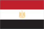
Flag description
- three equal horizontal bands of red (top), white, and black; the national emblem (a gold Eagle of Saladin facing the hoist side with a shield superimposed on its chest above a scroll bearing the name of the country in Arabic) centered in the white band; the band colors derive from the Arab Liberation flag and represent oppression (black), overcome through bloody struggle (red), to be replaced by a bright future (white)
- note
- similar to the flag of Syria, which has two green stars in the white band, Iraq, which has an Arabic inscription centered in the white band, and Yemen, which has a plain white band
Government type
republic
Independence
28 February 1922 (from UK protectorate status; the revolution that began on 23 July 1952 led to a republic being declared on 18 June 1953 and all British troops withdrawn on 18 June 1956); note - it was ca. 3200 B.C. that the Two Lands of Upper (southern) and Lower (northern) Egypt were first united politically
International law organization participation
accepts compulsory ICJ jurisdiction with reservations; non-party state to the ICCt
International organization participation
ABEDA, AfDB, AFESD, AMF, AU, BSEC (observer), CAEU, CD, CICA, COMESA, D-8, EBRD, FAO, G-15, G-24, G-77, IAEA, IBRD, ICAO, ICC (national committees), ICRM, IDA, IDB, IFAD, IFC, IFRCS, IHO, ILO, IMF, IMO, IMSO, Interpol, IOC, IOM, IPU, ISO, ITSO, ITU, LAS, MIGA, MINURSO, MINUSMA, MONUSCO, NAM, OAPEC, OAS (observer), OIC, OIF, OSCE (partner), PCA, UN, UNAMID, UNCTAD, UNESCO, UNHCR, UNIDO, UNMISS, UNOCI, UNRWA, UNWTO, UPU, WCO, WFTU (NGOs), WHO, WIPO, WMO, WTO
Judicial branch
- highest court(s)
- Supreme Constitutional Court or SCC (consists of the court president and 10 justices); the SCC serves as the final court of arbitrator on the constitutionality of laws and conflicts between lower courts regarding jurisdiction and rulings; Court of Cassation (CC) (consists of the court president and 550 judges organized in circuits with cases heard by panels of 5 judges); the CC is the highest appeals body for civil and criminal cases, also known as “ordinary justices"; Supreme Administrative Court (SAC) - consists of the court president and organized in circuits with cases heard by panels of 5 judges); the SAC is the highest court of the State Council
- judge selection and term of office
- under the 2014 constitution, all judges and justices selected by the Supreme Judiciary Council and appointed by the president of the Republic; tenure NA
- subordinate courts
- Courts of Appeal; Courts of First Instance; courts of limited jurisdiction; Family Court (established in 2004)
Legal system
mixed legal system based on Napoleonic civil and penal law, Islamic religious law, and vestiges of colonial-era laws; judicial review of the constitutionality of laws by the Supreme Constitutional Court
Legislative branch
- description
- unicameral House of Representatives (Majlis Al-Nowaab); according to 2014 election laws, will consist of up to 567 members; 420 members to be in elected in single- and multi-seat districts by simple majority vote, 120 members to be elected in party-list districts by simple majority vote, and up to 27 seats as presidential appointees
- election results (for previous legislature)
- Advisory Council (held 29 January and 14 February 2012) - percent of vote by party - Democratic Alliance for Egypt 45%, Alliance for Egypt (Islamic Bloc) 28.6%, New Wafd Party 8.5%, Egyptian Bloc 5.4%, other 12.5%; seats by party - Democratic Alliance for Egypt 105, Alliance for Egypt (Islamic Bloc) 45, New Wafd Party 14, Egyptian Bloc 8, other 4, independents 4, presidential appointees 90; People's Assembly (held in three stages 28 November 2011 to 11 January 2012) - percent of vote by party - Democratic Alliance for Egypt 37.5%, Alliance for Egypt (Islamic Bloc) 27.8%, New Wafd Party 9.2%, Egyptian Bloc 8.9%, Al-Wasat Party 3.7%, The Revolution Continues Alliance 2.8%, Reform and Development Party 2.2%, National Party of Egypt 1.6%, Freedom Party 1.9%, Egyptian Citizen Party 0.9%, other 3.5%; seats by party - Democratic Alliance of Egypt 235, Alliance for Egypt (Islamic Bloc) 123, New Wafd Party 38, Egyptian Bloc 35, Al-Wasat 10, Reform and Development Party 9, The Revolution Continues Alliance 8, National Party of Egypt 5, Egyptian Citizen Party 4, Freedom Party 4, independents 21, other 6, SCAF appointees 10
- elections (for new House of Representatives)
- initially scheduled for late December 2014, changed several times, latest to 18 October 2015
National anthem
- lyrics/music
- Younis-al QADI/Sayed DARWISH
- name
- "Bilady, Bilady, Bilady" (My Homeland, My Homeland, My Homeland)
- note
- adopted 1979; the current anthem, less militaristic than the previous one, was created after the signing of the 1979 peace treaty with Israel; Sayed DARWISH, commonly considered the father of modern Egyptian music, composed the anthem
National holiday
Revolution Day, 23 July (1952)
National symbol(s)
golden eagle, white lotus; national colors: red, white, black
Political parties and leaders
- Al-Dustour (Constitution) Party [Hala SHOKRALLAH]
- Al-Karama Party [Mohamed SAMY]
- Al-Nour [Yunis MAKHYUN]
- Al-Wasat Party [Mohamad Abdel LATIF]
- Al-Watan [Imad Abd al-GHAFUR]
- Building and Development Party or BDP [Tarek al-ZOMOR]
- Congress Party [Omar Mokhtar SEMEIDA]
- Egyptian National Movement Party [Ahmed SHAFIK]
- Egyptian Social Democratic Party [Mohamed Aboul GHAR]
- El Tagamu'u Party [Sayed Abdel AAL]
- Free Egyptians Party [Essam KHALIL]
- New Wafd Party [Sayed al-BADADWI]
- Popular Current Party [Hamdeen SABAHI]
- Reform and Development Party [Mohamad Anwar al-SADAT]
- Socialist Popular Alliance [Abdel Ghafar SHOUKR]
- Strong Egypt Party [Abdel Moneim Aboul FOTOUH]
- officially recognized
- Al-Asala [Ehab SHIHA]
Political pressure groups and leaders
NA
Suffrage
18 years of age; universal and compulsory
Economy
Agriculture - products
cotton, rice, corn, wheat, beans, fruits, vegetables; cattle, water buffalo, sheep, goats
Budget
- expenditures
- $99.14 billion (2014 est.)
- revenues
- $65.48 billion
Budget surplus (+) or deficit (-)
-11.8% of GDP (2014 est.)
Central bank discount rate
- 9.75% (30 October 2014)
- 8.75% (5 December 2013)
Commercial bank prime lending rate
- 11.8% (31 December 2014 est.)
- 12.29% (31 December 2013 est.)
Current account balance
- -$2.356 billion (2014 est.)
- $6.39 billion (2013 est.)
Debt - external
- $55.86 billion (31 December 2014 est.)
- $49.28 billion (31 December 2013 est.)
Distribution of family income - Gini index
- 30.8 (2008)
- 32.1 (2005)
Economy - overview
Occupying the northeast corner of the African continent, Egypt is bisected by the highly fertile Nile valley, where most economic activity takes place. Egypt's economy was highly centralized during the rule of former President Gamal Abdel NASSER but opened up considerably under former Presidents Anwar EL-SADAT and Mohamed Hosni MUBARAK. Cairo from 2004 to 2008 pursued business climate reforms to attract foreign investment and facilitate growth. Poor living conditions and limited job opportunities for the average Egyptian contribute to public discontent, a major factor leading to the January 2011 revolution that ousted Mubarak. The uncertain political, security, and policy environment since 2011 caused economic growth to slow significantly, hurting tourism, manufacturing, and other sectors and pushing up unemployment. Weak growth and limited foreign exchange earnings have made public finances unsustainable, leaving authorities dependent on expensive borrowing for deficit finance and on Gulf allies to help cover the import bill. Egypt's current Constitution passed in a referendum that took place in January 2014.
Exchange rates
- Egyptian pounds (EGP) per US dollar -
- 7.1 (2014 est.)
- 6.8708 (2013 est.)
- 6.06 (2012 est.)
- 5.9358 (2011 est.)
- 5.6219 (2010 est.)
Exports
- $27.15 billion (2014 est.)
- $27.87 billion (2013 est.)
Exports - commodities
crude oil and petroleum products, fruits and vegetables, cotton, textiles, metal products, chemicals, processed food
Exports - partners
Italy 9.2%, Saudi Arabia 7.4%, India 7.2%, Turkey 5.4%, US 4.2% (2014)
Fiscal year
1 July - 30 June
GDP - composition, by end use
- (2014 est.)
- exports of goods and services
- 15%
- government consumption
- 12%
- household consumption
- 80.3%
- imports of goods and services
- -20.7%
- investment in fixed capital
- 13%
- investment in inventories
- 0.5%
GDP - composition, by sector of origin
- agriculture
- 14.6%
- industry
- 38.9%
- services
- 46.5% (2014 est.)
GDP - per capita (PPP)
- $10,900 (2014 est.)
- $10,600 (2013 est.)
- $10,400 (2012 est.)
- note
- data are in 2014 US dollars
GDP - real growth rate
- 2.2% (2014 est.)
- 2.1% (2013 est.)
- 2.2% (2012 est.)
GDP (official exchange rate)
$286.4 billion (2014 est.)
GDP (purchasing power parity)
- $943.1 billion (2014 est.)
- $923.1 billion (2013 est.)
- $904.1 billion (2012 est.)
- note
- data are in 2014 US dollars
Gross national saving
- 13.2% of GDP (2014 est.)
- 11.8% of GDP (2013 est.)
- 12.5% of GDP (2012 est.)
Household income or consumption by percentage share
- highest 10%
- 26.6% (2008)
- lowest 10%
- 4%
Imports
- $55.26 billion (2014 est.)
- $55.46 billion (2013 est.)
Imports - commodities
machinery and equipment, foodstuffs, chemicals, wood products, fuels
Imports - partners
China 11.2%, Germany 7.9%, US 7.4%, Kuwait 5.1%, Italy 4.6%, Ukraine 4.4%, Russia 4.2%, Turkey 4.1% (2014)
Industrial production growth rate
1.5% (2014 est.)
Industries
textiles, food processing, tourism, chemicals, pharmaceuticals, hydrocarbons, construction, cement, metals, light manufactures
Inflation rate (consumer prices)
- 10.1% (2014 est.)
- 9.5% (2013 est.)
Labor force
28.26 million (2014 est.)
Labor force - by occupation
- agriculture
- 29%
- industry
- 24%
- services
- 47% (2011 est.)
Market value of publicly traded shares
- $73.04 billion (30 November 2014 est.)
- $58.01 billion (31 December 2012 est.)
- $48.68 billion (31 December 2011 est.)
Population below poverty line
25.2% (2011 est.)
Public debt
- 93.8% of GDP (2014 est.)
- 91.5% of GDP (2013 est.)
- note
- data cover central government debt and includes debt instruments issued (or owned) by government entities other than the treasury; the data include treasury debt held by foreign entities; the data include debt issued by subnational entities, as well as intra-governmental debt; intra-governmental debt consists of treasury borrowings from surpluses in the social funds, such as for retirement, medical care, and unemployment; debt instruments for the social funds are sold at public auctions
Reserves of foreign exchange and gold
- $15.13 billion (31 December 2014 est.)
- $16.12 billion (31 December 2013 est.)
Stock of broad money
- $219 billion (31 December 2014 est.)
- $199.5 billion (31 December 2013 est.)
Stock of direct foreign investment - abroad
- $6.684 billion (31 December 2014 est.)
- $6.475 billion (31 December 2013 est.)
Stock of direct foreign investment - at home
- $79.19 billion (31 December 2014 est.)
- $76.76 billion (31 December 2013 est.)
Stock of domestic credit
- $225.4 billion (31 December 2014 est.)
- $217.3 billion (31 December 2013 est.)
Stock of narrow money
- $60.18 billion (31 December 2014 est.)
- $53.71 billion (31 December 2013 est.)
Taxes and other revenues
23% of GDP (2014 est.)
Unemployment rate
- 13.4% (2014 est.)
- 13.2% (2013 est.)
Energy
Carbon dioxide emissions from consumption of energy
206.3 million Mt (2012 est.)
Crude oil - exports
189,000 bbl/day (2013 est.)
Crude oil - imports
80,000 bbl/day (2013 est.)
Crude oil - production
700,000 bbl/day (2013 est.)
Crude oil - proved reserves
4.4 billion bbl (1 January 2014 est.)
Electricity - consumption
129.4 billion kWh (2011 est.)
Electricity - exports
1.679 billion kWh (2012 est.)
Electricity - from fossil fuels
90% of total installed capacity (2012 est.)
Electricity - from hydroelectric plants
8% of total installed capacity (2012 est.)
Electricity - from nuclear fuels
0% of total installed capacity (2014 est.)
Electricity - from other renewable sources
2% of total installed capacity (2012 est.)
Electricity - imports
102 million kWh (2012 est.)
Electricity - installed generating capacity
27 million kW (2013 est.)
Electricity - production
152 billion kWh (2012 est.)
Natural gas - consumption
53.8 billion cu m (2013 est.)
Natural gas - exports
3.823 billion cu m (2013 est.)
Natural gas - imports
2.832 billion cu m (2013 est.)
Natural gas - production
56.63 billion cu m (2013 est.)
Natural gas - proved reserves
2.18 trillion cu m (1 January 2014 est.)
Refined petroleum products - consumption
770,000 bbl/day (2013 est.)
Refined petroleum products - exports
83,000 bbl/day (2013 est.)
Refined petroleum products - imports
170,000 bbl/day (2013 est.)
Refined petroleum products - production
445,000 bbl/day (2013 est.)
Communications
Broadcast media
mix of state-run and private broadcast media; state-run TV operates 2 national and 6 regional terrestrial networks, as well as a few satellite channels; about 20 private satellite channels and a large number of Arabic satellite channels are available via subscription; state-run radio operates about 70 stations belonging to 8 networks; 2 privately owned radio stations operational (2008)
Internet country code
.eg
Internet users
- percent of population
- 48.3% (2014 est.)
- total
- 42 million
Radio broadcast stations
AM 42 (plus 15 repeaters), FM 22, shortwave 1 (2010)
Telephone system
- domestic
- largest fixed-line system in the region; multiple mobile-cellular networks with a near 100-percent penetration of the market
- general assessment
- underwent extensive upgrading during 1990s; principal centers at Alexandria, Cairo, Al Mansurah, Ismailia, Suez, and Tanta are connected by coaxial cable and microwave radio relay
- international
- country code - 20; landing point for Aletar, the SEA-ME-WE-3 and SEA-ME-WE-4 submarine cable networks, Link Around the Globe (FLAG) Falcon and FLAG FEA; satellite earth stations - 4 (2 Intelsat - Atlantic Ocean and Indian Ocean, 1 Arabsat, and 1 Inmarsat); tropospheric scatter to Sudan; microwave radio relay to Israel; a participant in Medarabtel (2015)
Telephones - fixed lines
- subscriptions per 100 inhabitants
- 7 (2014 est.)
- total subscriptions
- 6.32 million
Telephones - mobile cellular
- subscriptions per 100 inhabitants
- 110 (2014 est.)
- total
- 95.3 million
Television broadcast stations
64 (2010)
Transportation
Airports
83 (2013)
Airports - with paved runways
- 1,524 to 2,437 m
- 15
- 2,438 to 3,047 m
- 36
- over 3,047 m
- 15
- total
- 72
- under 914 m
- 6 (2013)
Airports - with unpaved runways
- 3 (2013)
- 1,524 to 2,437 m
- 3
- 2,438 to 3,047 m
- 1
- 914 to 1,523 m
- 4
- total
- 11
Heliports
7 (2013)
Merchant marine
- by type
- bulk carrier 16, cargo 20, container 3, passenger/cargo 7, petroleum tanker 12, roll on/roll off 9
- foreign-owned
- 13 (Denmark 1, France 1, Greece 8, Jordan 2, Lebanon 1)
- registered in other countries
- 42 (Cambodia 4, Georgia 7, Honduras 2, Liberia 3, Malta 1, Marshall Islands 1, Moldova 5, Panama 11, Saint Kitts and Nevis 1, Saint Vincent and the Grenadines 2, Saudi Arabia 1, Sierra Leone 3, unknown 1) (2010)
- total
- 67
Pipelines
condensate 486 km; condensate/gas 74 km; gas 7,986 km; liquid petroleum gas 957 km; oil 5,225 km; oil/gas/water 37 km; refined products 895 km; water 65 km (2013)
Ports and terminals
- container port(s) (TEUs)
- Alexandria (1,108,826), Port Said(East) (2,617,043), Port Said(West) (1,138,753)
- LNG terminal(s) (export)
- Damietta, Idku (Abu Qir Bay)
- major seaport(s)
- Mediterranean Sea - Alexandria, Damietta, El Dekheila, Port Said; Gulf of Suez - Suez
- oil terminal(s)
- Ain Sukhna terminal, Sidi Kerir terminal
Railways
- standard gauge
- 5,085 km 1.435-m gauge (62 km electrified) (2014)
- total
- 5,085 km
Roadways
- paved
- 126,742 km (includes 838 km of expressways)
- total
- 137,430 km
- unpaved
- 10,688 km (2010)
Waterways
3,500 km (includes the Nile River, Lake Nasser, Alexandria-Cairo Waterway, and numerous smaller canals in Nile Delta; the Suez Canal (193.5 km including approaches) is navigable by oceangoing vessels drawing up to 17.68 m) (2011)
Military and Security
Manpower available for military service
- females age 16-49
- 20,145,021 (2010 est.)
- males age 16-49
- 21,012,199
Manpower fit for military service
- females age 16-49
- 17,244,838 (2010 est.)
- males age 16-49
- 18,060,543
Manpower reaching militarily significant age annually
- female
- 748,647 (2010 est.)
- male
- 783,405
Military branches
Army, Navy, Air Force, Air Defense Forces (2015)
Military expenditures
- 1.67% of GDP (2013)
- 1.72% of GDP (2012)
- 1.86% of GDP (2011)
- 1.72% of GDP (2010)
Military service age and obligation
18-30 years of age for male conscript military service; service obligation - 18-36 months, followed by a 9-year reserve obligation; voluntary enlistment possible from age 16 (2012)
Transnational Issues
Disputes - international
Sudan claims but Egypt de facto administers security and economic development of Halaib region north of the 22nd parallel boundary; Egypt no longer shows its administration of the Bir Tawil trapezoid in Sudan on its maps; Gazan breaches in the security wall with Egypt in January 2008 highlight difficulties in monitoring the Sinai border; Saudi Arabia claims Egyptian-administered islands of Tiran and Sanafir
Illicit drugs
transit point for cannabis, heroin, and opium moving to Europe, Israel, and North Africa; transit stop for Nigerian drug couriers; concern as money laundering site due to lax enforcement of financial regulations
Refugees and internally displaced persons
- refugees (country of origin)
- 70,023 (West Bank and Gaza Strip); 12,730 (Sudan); 5,149 (Iraq) (2014); 132,375 (Syria); 7,365 (Somalia) (2015)
- stateless persons
- 20 (2014)