2010 Edition
CIA World Factbook 2010 (Project Gutenberg)
Introduction
Background
The French Territory of the Afars and the Issas became Djibouti in 1977. Hassan Gouled APTIDON installed an authoritarian one-party state and proceeded to serve as president until 1999. Unrest among the Afars minority during the 1990s led to a civil war that ended in 2001 following the conclusion of a peace accord between Afar rebels and the Issa-dominated government. In 1999, Djibouti's first multi-party presidential elections resulted in the election of Ismail Omar GUELLEH; he was re-elected to a second term in 2005. Djibouti occupies a strategic geographic location at the mouth of the Red Sea and serves as an important transshipment location for goods entering and leaving the east African highlands. The present leadership favors close ties to France, which maintains a significant military presence in the country but also has strong ties with the US. Djibouti hosts the only US military base in sub-Saharan Africa and is a front-line state in the global war on terrorism.
Geography
Area
- land
- 23,180 sq km
- total
- 23,200 sq km
- water
- 20 sq km
Area - comparative
slightly smaller than Massachusetts
Climate
desert; torrid, dry
Coastline
314 km
Elevation extremes
- highest point
- Moussa Ali 2,028 m
- lowest point
- Lac Assal -155 m
Environment - current issues
inadequate supplies of potable water; limited arable land; desertification; endangered species
Environment - international agreements
- party to
- Biodiversity, Climate Change, Climate Change-Kyoto Protocol, Desertification, Endangered Species, Hazardous Wastes, Law of the Sea, Ozone Layer Protection, Ship Pollution, Wetlands signed, but not ratified: none of the selected agreements
Freshwater withdrawal (domestic/industrial/agricultural)
- per capita
- 25 cu m/yr (2000)
- total
- 0.02 cu km/yr (84%/0%/16%)
Geographic coordinates
11 30 N, 43 00 E
Geography - note
strategic location near world's busiest shipping lanes and close to Arabian oilfields; terminus of rail traffic into Ethiopia; mostly wasteland; Lac Assal (Lake Assal) is the lowest point in Africa
Irrigated land
10 sq km (2003)
Land boundaries
- border countries
- Eritrea 109 km, Ethiopia 349 km, Somalia 58 km
- total
- 516 km
Land use
- arable land
- 0.04%
- other
- 99.96% (2005)
- permanent crops
- 0%
Location
Eastern Africa, bordering the Gulf of Aden and the Red Sea, between Eritrea and Somalia
Map references
Africa
Maritime claims
- contiguous zone
- 24 nm
- exclusive economic zone
- 200 nm
- territorial sea
- 12 nm
Natural hazards
- earthquakes; droughts; occasional cyclonic disturbances from the Indian Ocean bring heavy rains and flash floods
- volcanism
- Djibouti experiences limited volcanic activity; Ardoukoba (elev. 298 m, 978 ft) last erupted in 1978; Manda-Inakir, located along the Ethiopian border, is also historically active
Natural resources
potential geothermal power, gold, clay, granite, limestone, marble, salt, diatomite, gypsum, pumice, petroleum
Terrain
coastal plain and plateau separated by central mountains
Total renewable water resources
0.3 cu km (1997)
People and Society
Age structure
0-14 years: 36.3% (male 131,878/female 131,449) 15-64 years: 60.4% (male 194,503/female 243,495) 65 years and over: 3.2% (male 10,462/female 12,835) (2010 est.)
Birth rate
25.58 births/1,000 population (2010 est.)
Death rate
8.37 deaths/1,000 population (July 2010 est.)
Education expenditures
8.7% of GDP (2007)
Ethnic groups
Somali 60%, Afar 35%, other 5% (includes French, Arab, Ethiopian, and Italian)
HIV/AIDS - adult prevalence rate
3.1% (2007 est.)
HIV/AIDS - deaths
1,100 (2007 est.)
HIV/AIDS - people living with HIV/AIDS
16,000 (2007 est.)
Infant mortality rate
- female
- 48.52 deaths/1,000 live births (2010 est.)
- male
- 64.55 deaths/1,000 live births
- total
- 56.65 deaths/1,000 live births
Languages
French (official), Arabic (official), Somali, Afar
Life expectancy at birth
- female
- 63.22 years (2010 est.)
- male
- 58.31 years
- total population
- 60.73 years
Literacy
- definition: age 15 and over can read and write
- female
- 58.4% (2003 est.)
- male
- 78%
- total population
- 67.9%
Major infectious diseases
- degree of risk
- high
- food or waterborne diseases
- bacterial and protozoal diarrhea, hepatitis A and E, and typhoid fever
- vectorborne disease
- malaria note: highly pathogenic H5N1 avian influenza has been identified in this country; it poses a negligible risk with extremely rare cases possible among US citizens who have close contact with birds (2009)
Median age
- female
- 22.8 years (2010 est.)
- male
- 19.8 years
- total
- 21.4 years
Nationality
- adjective
- Djiboutian
- noun
- Djiboutian(s)
Net migration rate
4.6 migrant(s)/1,000 population
Population
740,528 (July 2010 est.)
Population growth rate
2.181% (2010 est.)
Religions
Muslim 94%, Christian 6%
School life expectancy (primary to tertiary education)
- female
- 4 years (2007)
- male
- 5 years
- total
- 5 years
Sex ratio
- at birth
- 1.03 male(s)/female under 15 years: 1 male(s)/female 15-64 years: 0.8 male(s)/female 65 years and over: 0.81 male(s)/female
- total population
- 0.86 male(s)/female (2010 est.)
Total fertility rate
2.79 children born/woman (2010 est.)
Urbanization
- rate of urbanization
- 2.2% annual rate of change (2005-10 est.)
- urban population
- 87% of total population (2008)
Government
Administrative divisions
6 districts (cercles, singular - cercle); Ali Sabieh, Arta, Dikhil, Djibouti, Obock, Tadjourah
Capital
- geographic coordinates
- 11 35 N, 43 09 E
- name
- Djibouti
- time difference
- UTC+3 (8 hours ahead of Washington, DC during Standard Time)
Constitution
approved by referendum 4 September 1992; note - constitution allows for multiparties
Country name
- conventional long form
- Republic of Djibouti
- conventional short form
- Djibouti
- former
- French Territory of the Afars and Issas, French Somaliland
- local long form
- Republique de Djibouti/Jumhuriyat Jibuti
- local short form
- Djibouti/Jibuti
Diplomatic representation from the US
- chief of mission
- Ambassador James C. SWAN
- embassy
- Plateau du Serpent, Boulevard Marechal Joffre, Djibouti
- FAX
- [253] 35 39 40
- mailing address
- B. P. 185, Djibouti
- telephone
- [253] 35 39 95
Diplomatic representation in the US
- chancery
- Suite 515, 1156 15th Street NW, Washington, DC 20005
- chief of mission
- Ambassador Roble OLHAYE Oudine
- FAX
- [1] (202) 331-0302
- telephone
- [1] (202) 331-0270
Executive branch
- cabinet
- Council of Ministers responsible to the president (For more information visit the World Leaders website )
- chief of state
- President Ismail Omar GUELLEH (since 8 May 1999)
- election results
- Ismail Omar GUELLEH reelected president; percent of vote - Ismail Omar GUELLEH 100%
- elections
- president elected by popular vote for a five-year term; president is eligible to hold office until age 75; election last held on 8 April 2005 (next to be held by April 2011); prime minister appointed by the president
- head of government
- Prime Minister Mohamed Dileita DILEITA (since 4 March 2001)
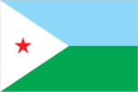
Flag description
two equal horizontal bands of light blue (top) and light green with a white isosceles triangle based on the hoist side bearing a red five-pointed star in the center; blue stands for sea and sky and the Issa Somali people; green symbolizes earth and the Afar people; white represents peace; the red star recalls the struggle for independence and stands for unity
Government type
republic
Independence
27 June 1977 (from France)
International organization participation
ACP, AfDB, AFESD, AMF, AU, COMESA, FAO, G-77, IBRD, ICAO, ICCt, ICRM, IDA, IDB, IFAD, IFC, IFRCS, IGAD, ILO, IMF, IMO, Interpol, IOC, IPU, ITU, ITUC, LAS, MIGA, MINURSO, NAM, OIC, OIF, OPCW, UN, UNCTAD, UNESCO, UNHCR, UNIDO, UNWTO, UPU, WCO, WFTU, WHO, WIPO, WMO, WTO
Judicial branch
Supreme Court or Cour Supreme
Legal system
based on French civil law system, traditional practices, and Islamic law; accepts ICJ compulsory jurisdiction with reservations
Legislative branch
- unicameral Chamber of Deputies or Chambre des Deputes (65 seats; members elected by popular vote to serve five-year terms); note - constitutional amendments in 2010 provided for the establishment of a senate
- election results
- percent of vote by party - NA; seats - UMP (coalition of parties associated with President Ismail Omar GUELLAH) 65
- elections
- last held on 8 February 2008 (next to be held in 2013)
National anthem
- lyrics/music
- Aden ELMI/Abdi ROBLEH note: adopted 1977
- name
- "Jabuuti" (Djibouti)
National holiday
Independence Day, 27 June (1977)
Political parties and leaders
Democratic National Party or PND [ADEN Robleh Awaleh]; Democratic Renewal Party or PRD [Abdillahi HAMARITEH]; Djibouti Development Party or PDD [Mohamed Daoud CHEHEM]; Front pour la Restauration de l'Unite Democratique or FRUD [Ali Mohamed DAOUD]; People's Progress Assembly or RPP [Ismail Omar GUELLEH] (governing party); Peoples Social Democratic Party or PPSD [Moumin Bahdon FARAH]; Republican Alliance for Democracy or ARD [Ahmed YOUSSOUF]; Union for a Presidential Majority or UMP [Mohamed Dileita DILEITA] (a coalition of parties including RPP, FRUD, PND, and PPSD); Union for Democracy and Justice or UDJ
Political pressure groups and leaders
Union for Presidential Majority UMP (coalition includes RPP, FRUD, PPSD and PND); Union for Democratic Changeover or UAD (opposition coalition includes ARD, MRDD, and UDJ)
Suffrage
18 years of age; universal
Economy
Agriculture - products
fruits, vegetables; goats, sheep, camels, animal hides
Commercial bank prime lending rate
NA% (31 December 2009 est.) 11.56% (31 December 2008 est.)
Current account balance
-$352 million (2009 est.) -$212 million (2007 est.)
Debt - external
$428 million (2006)
Economy - overview
The economy is based on service activities connected with the country's strategic location and status as a free trade zone in the Horn of Africa. Two-thirds of Djibouti's inhabitants live in the capital city; the remainder are mostly nomadic herders. Scanty rainfall limits crop production to fruits and vegetables, and most food must be imported. Djibouti provides services as both a transit port for the region and an international transshipment and refueling center. Imports and exports from landlocked neighbor Ethiopia represent 70% of port activity at Djibouti's container terminal. Djibouti has few natural resources and little industry. The nation is, therefore, heavily dependent on foreign assistance to help support its balance of payments and to finance development projects. An unemployment rate of nearly 60% in urban areas continues to be a major problem. While inflation is not a concern, due to the fixed tie of the Djiboutian franc to the US dollar, the artificially high value of the Djiboutian franc adversely affects Djibouti's balance of payments. Per capita consumption dropped an estimated 35% between 1999 and 2006 because of recession, civil war, and a high population growth rate (including immigrants and refugees). Djibouti has experienced relatively minimal impact from the global economic downturn, but its reliance on diesel-generated electricity and imported food leave average consumers vulnerable to global price shocks.
Electricity - consumption
260.4 million kWh (2007 est.)
Electricity - exports
0 kWh (2008 est.)
Electricity - imports
0 kWh (2008 est.)
Electricity - production
280 million kWh (2007 est.)
Exchange rates
Djiboutian francs (DJF) per US dollar - 177.71 (2007), 174.75 (2006), 177.72 (2005), 177.72 (2004), 177.72 (2003)
Exports
$100 million (2009); $340 million
Exports - commodities
reexports, hides and skins, coffee (in transit)
Exports - partners
Somalia 76.68%, France 4.89%, UAE 4.22% (2009)
GDP - composition by sector
- agriculture
- 3.2%
- industry
- 14.9%
- services
- 81.9% (2006)
GDP - per capita (PPP)
$2,800 (2010 est.) $2,800 (2009 est.) $2,700 (2008 est.) note: data are in 2010 US dollars
GDP - real growth rate
4.8% (2010 est.) 5% (2009 est.) 5.8% (2008 est.)
GDP (official exchange rate)
$1.139 billion (2010 est.)
GDP (purchasing power parity)
$2.099 billion (2010 est.) $2.003 billion (2009 est.) $1.908 billion (2008 est.) note: data are in 2010 US dollars
Household income or consumption by percentage share
lowest 10%: 2.4% highest 10%: 30.9% (2002)
Imports
$644 million (2009 est.) $1.555 billion (2006)
Imports - commodities
foods, beverages, transport equipment, chemicals, petroleum products
Imports - partners
Saudi Arabia 16.26%, India 16.03%, China 14.26%, US 9.57%, Malaysia 6.63%, Japan 4.74% (2009)
Industries
construction, agricultural processing
Inflation rate (consumer prices)
6% (2009 est.) 5%
Labor force
351,700 (2007)
Labor force - by occupation
- agriculture
- NA%
- industry
- NA%
- services
- NA%
Natural gas - consumption
0 cu m (2008 est.)
Natural gas - exports
0 cu m (2008 est.)
Natural gas - imports
0 cu m (2008 est.)
Natural gas - production
0 cu m (2008 est.)
Natural gas - proved reserves
0 cu m (1 January 2010 est.)
Oil - consumption
12,000 bbl/day (2009 est.)
Oil - exports
19 bbl/day (2007 est.)
Oil - imports
8,476 bbl/day (2007 est.)
Oil - production
0 bbl/day (2009 est.)
Oil - proved reserves
0 bbl (1 January 2010 est.)
Population below poverty line
42% (2007 est.)
Stock of broad money
$940.8 million (31 December 2009 est.) $800.8 million (31 December 2008 est.)
Stock of domestic credit
$339 million (31 December 2009) $269.9 million (31 December 2008)
Stock of narrow money
$577.8 million (31 December 2009) $462.7 million (31 December 2008)
Unemployment rate
59% (2007 est.) note: data are for urban areas, 83% in rural areas
Communications
Broadcast media
maintains restrictions on the licensing and operation of broadcast media; state-owned Radiodiffusion-Television de Djibouti (RTD) operates the sole terrestrial TV station as well as the only 2 domestic radio networks; no private TV or radio stations; transmissions of several international broadcasters are available (2007)
Internet country code
.dj
Internet hosts
195 (2010)
Internet users
25,900 (2009)
Telephone system
- domestic
- Djibouti Telecom is the sole provider of telecommunications services and utilizes mostly a microwave radio relay network; fiber-optic cable is installed in the capital; rural areas connected via wireless local loop radio systems; mobile cellular coverage is primarily limited to the area in and around Djibouti city
- general assessment
- telephone facilities in the city of Djibouti are adequate, as are the microwave radio relay connections to outlying areas of the country
- international
- country code - 253; landing point for the SEA-ME-WE-3 optical telecommunications submarine cable with links to Asia, the Middle East, and Europe; satellite earth stations - 2 (1 Intelsat - Indian Ocean and 1 Arabsat); Medarabtel regional microwave radio relay telephone network (2009)
Telephones - main lines in use
16,800 (2009)
Telephones - mobile cellular
128,800 (2009)
Transportation
Airports
13 (2010)
Airports - with paved runways
- total
- 3 over 3,047 m: 1 2,438 to 3,047 m: 1 1,524 to 2,437 m: 1 (2010)
Airports - with unpaved runways
- total
- 10 1,524 to 2,437 m: 1 914 to 1,523 m: 7 under 914 m: 2 (2010)
Ports and terminals
Djibouti
Railways
- narrow gauge
- 100 km 1.000-m gauge note: railway is under joint control of Djibouti and Ethiopia but is largely inoperable (2008)
- total
- 100 km (Djibouti segment of the 781 km Addis Ababa-Djibouti railway)
Roadways
- paved
- 1,226 km
- total
- 3,065 km
- unpaved
- 1,839 km (2000)
Transportation - note
the International Maritime Bureau reports offshore waters in the Gulf of Aden are high risk for piracy; numerous vessels, including commercial shipping and pleasure craft, have been attacked and hijacked both at anchor and while underway; crew, passengers, and cargo are held for ransom
Military and Security
Manpower available for military service
males age 16-49: 165,000 females age 16-49: 213,894 (2010 est.)
Manpower fit for military service
males age 16-49: 110,441 females age 16-49: 147,939 (2010 est.)
Manpower reaching militarily significant age annually
- female
- 8,503 (2010 est.)
- male
- 8,260
Military branches
Djibouti National Army (includes Navy and Air Force)
Military expenditures
3.8% of GDP (2006)
Military service age and obligation
18 years of age for voluntary military service; 16-25 years of age for voluntary military training; no conscription (2008)
Transnational Issues
Disputes - international
Djibouti maintains economic ties and border accords with "Somaliland" leadership while maintaining some political ties to various factions in Somalia; Kuwait is chief investor in the 2008 restoration and upgrade of the Ethiopian-Djibouti rail link; in 2008, Eritrean troops move across the border on Ras Doumera peninsula and occupy Doumera Island with undefined sovereignty in the Red Sea
Refugees and internally displaced persons
- refugees (country of origin)
- 8,642 (Somalia) (2007) page last updated on January 19, 2011 ======================================================================