2013 Edition
CIA World Factbook 2013 Archive (HTML)
Introduction
Background
Upon independence in 1960, the former French region of Middle Congo became the Republic of the Congo. A quarter century of experimentation with Marxism was abandoned in 1990 and a democratically elected government took office in 1992. A brief civil war in 1997 restored former Marxist President Denis SASSOU-Nguesso, and ushered in a period of ethnic and political unrest. Southern-based rebel groups agreed to a final peace accord in March 2003, but the calm is tenuous and refugees continue to present a humanitarian crisis. The Republic of Congo is one of Africa's largest petroleum producers, but with declining production it will need new offshore oil finds to sustain its oil earnings over the long term.
Geography
Area
- 342,000 sq km 341,500 sq km 500 sq km
- total
- 342,000 sq km
- water
- 500 sq km
Area - comparative
slightly smaller than Montana
Climate
tropical; rainy season (March to June); dry season (June to October); persistent high temperatures and humidity; particularly enervating climate astride the Equator
Coastline
169 km
Elevation extremes
- Atlantic Ocean 0 m Mount Berongou 903 m
- highest point
- Mount Berongou 903 m
- lowest point
- Atlantic Ocean 0 m
Environment - current issues
air pollution from vehicle emissions; water pollution from the dumping of raw sewage; tap water is not potable; deforestation
Environment - international agreements
- Biodiversity, Climate Change, Climate Change-Kyoto Protocol, Desertification, Endangered Species, Hazardous Wastes, Law of the Sea, Ozone Layer Protection, Ship Pollution, Tropical Timber 83, Tropical Timber 94, Wetlands none of the selected agreements
- party to
- Biodiversity, Climate Change, Climate Change-Kyoto Protocol, Desertification, Endangered Species, Hazardous Wastes, Law of the Sea, Ozone Layer Protection, Ship Pollution, Tropical Timber 83, Tropical Timber 94, Wetlands
- signed, but not ratified
- none of the selected agreements
Freshwater withdrawal (domestic/industrial/agricultural)
- 0.05 cu km/yr (69%/26%/4%) 13.99 cu m/yr (2005)
- per capita
- 13.99 cu m/yr (2005)
- total
- 0.05 cu km/yr (69%/26%/4%)
Geographic coordinates
1 00 S, 15 00 E
Geography - note
about 70% of the population lives in Brazzaville, Pointe-Noire, or along the railroad between them
Irrigated land
20 sq km (2003)
Land boundaries
- 5,504 km Angola 201 km, Cameroon 523 km, Central African Republic 467 km, Democratic Republic of the Congo 2,410 km, Gabon 1,903 km
- border countries
- Angola 201 km, Cameroon 523 km, Central African Republic 467 km, Democratic Republic of the Congo 2,410 km, Gabon 1,903 km
- total
- 5,504 km
Land use
- 1.46% 0.18% 98.36% (2011)
- arable land
- 1.46%
- other
- 98.36% (2011)
- permanent crops
- 0.18%
Location
Central Africa, bordering the South Atlantic Ocean, between Angola and Gabon
Map references
Africa
Maritime claims
- 200 nm
- territorial sea
- 200 nm
Natural hazards
seasonal flooding
Natural resources
petroleum, timber, potash, lead, zinc, uranium, copper, phosphates, gold, magnesium, natural gas, hydropower
Terrain
coastal plain, southern basin, central plateau, northern basin
Total renewable water resources
832 cu km (2011)
People and Society
Age structure
- 45.1% (male 1,020,784/female 1,006,148) 20.6% (male 464,410/female 460,955) 28.2% (male 636,447/female 628,629) 3.4% (male 67,117/female 84,919) 2.7% (male 50,358/female 72,922) (2013 est.)
- 0-14 years
- 45.1% (male 1,020,784/female 1,006,148)
- 15-24 years
- 20.6% (male 464,410/female 460,955)
- 25-54 years
- 28.2% (male 636,447/female 628,629)
- 55-64 years
- 3.4% (male 67,117/female 84,919)
- 65 years and over
- 2.7% (male 50,358/female 72,922) (2013 est.)
Birth rate
39.63 births/1,000 population (2013 est.)
Child labor - children ages 5-14
- 252,171 25 % (2005 est.)
- percentage
- 25 % (2005 est.)
- total number
- 252,171
Children under the age of 5 years underweight
11.8% (2005)
Contraceptive prevalence rate
44.7% (2011/12)
Death rate
11.03 deaths/1,000 population (2013 est.)
Dependency ratios
- 84.9 % 78.7 % 6.3 % 15.9 (2013)
- elderly dependency ratio
- 6.3 %
- potential support ratio
- 15.9 (2013)
- total dependency ratio
- 84.9 %
- youth dependency ratio
- 78.7 %
Drinking water source
- urban: 95% of population rural: 32% of population total: 71% of population urban: 5% of population rural: 68% of population total: 29% of population (2010 est.)
- rural
- 68% of population
- total
- 29% of population (2010 est.)
- urban
- 5% of population
Education expenditures
6.2% of GDP (2010)
Ethnic groups
Kongo 48%, Sangha 20%, M'Bochi 12%, Teke 17%, Europeans and other 3%
Health expenditures
2.5% of GDP (2011)
HIV/AIDS - adult prevalence rate
3.4% (2009 est.)
HIV/AIDS - deaths
5,100 (2009 est.)
HIV/AIDS - people living with HIV/AIDS
77,000 (2009 est.)
Hospital bed density
1.6 beds/1,000 population (2005)
Infant mortality rate
- 72.45 deaths/1,000 live births 77.76 deaths/1,000 live births 66.98 deaths/1,000 live births (2013 est.)
- female
- 66.98 deaths/1,000 live births (2013 est.)
- total
- 72.45 deaths/1,000 live births
Languages
French (official), Lingala and Monokutuba (lingua franca trade languages), many local languages and dialects (of which Kikongo is the most widespread)
Life expectancy at birth
- 55.6 years 54.27 years 56.96 years (2013 est.)
- female
- 56.96 years (2013 est.)
- total population
- 55.6 years
Literacy
- age 15 and over can read and write 83.8% 89.6% 78.4% (2003 est.)
- definition
- age 15 and over can read and write
- female
- 78.4% (2003 est.)
- male
- 89.6%
- total population
- 83.8%
Major infectious diseases
- very high bacterial and protozoal diarrhea, hepatitis A, and typhoid fever malaria and dengue fever rabies schistosomiasis (2013)
- animal contact disease
- rabies
- degree of risk
- very high
- food or waterborne diseases
- bacterial and protozoal diarrhea, hepatitis A, and typhoid fever
- vectorborne disease
- malaria and dengue fever
- water contact disease
- schistosomiasis (2013)
Major urban areas - population
BRAZZAVILLE (capital) 1.611 million (2011)
Maternal mortality rate
560 deaths/100,000 live births (2010)
Median age
- 17.1 years 16.9 years 17.3 years (2013 est.)
- female
- 17.3 years (2013 est.)
- male
- 16.9 years
- total
- 17.1 years
Mother's mean age at first birth
19.8 (2011-12 est.)
Nationality
- Congolese (singular and plural) Congolese or Congo
- adjective
- Congolese or Congo
- noun
- Congolese (singular and plural)
Net migration rate
0 migrant(s)/1,000 population (2013 est.)
Obesity - adult prevalence rate
4.7% (2008)
Physicians density
0.1 physicians/1,000 population (2007)
Population
4,492,689 (July 2013 est.) estimates for this country explicitly take into account the effects of excess mortality due to AIDS; this can result in lower life expectancy, higher infant mortality, higher death rates, lower population growth rates, and changes in the distribution of population by age and sex than would otherwise be expected
Population growth rate
2.86% (2013 est.)
Religions
Christian 50%, animist 48%, Muslim 2%
Sanitation facility access
- urban: 20% of population rural: 15% of population total: 18% of population urban: 80% of population rural: 85% of population total: 82% of population (2010 est.)
- rural
- 85% of population
- total
- 82% of population (2010 est.)
- urban
- 80% of population
School life expectancy (primary to tertiary education)
- 9 years 10 years 9 years (2003)
- female
- 9 years (2003)
- male
- 10 years
- total
- 9 years
Sex ratio
- 1.03 male(s)/female 1.01 male(s)/female 1.01 male(s)/female 1.01 male(s)/female 0.79 male(s)/female 0.69 male(s)/female 0.99 male(s)/female (2013 est.)
- 0-14 years
- 1.01 male(s)/female
- 15-24 years
- 1.01 male(s)/female
- 25-54 years
- 1.01 male(s)/female
- 55-64 years
- 0.79 male(s)/female
- 65 years and over
- 0.69 male(s)/female
- at birth
- 1.03 male(s)/female
- total population
- 0.99 male(s)/female (2013 est.)
Total fertility rate
5.49 children born/woman (2013 est.)
Urbanization
- 63.7% of total population (2011) 2.84% annual rate of change (2010-15 est.)
- rate of urbanization
- 2.84% annual rate of change (2010-15 est.)
- urban population
- 63.7% of total population (2011)
Government
Administrative divisions
10 regions (regions, singular - region) and 2 commune*; Bouenza, Brazzaville*, Cuvette, Cuvette-Ouest, Kouilou, Lekoumou, Likouala, Niari, Plateaux, Pointe-Noire*, Pool, Sangha
Capital
- Brazzaville 4 15 S, 15 17 E UTC+1 (6 hours ahead of Washington, DC during Standard Time)
- geographic coordinates
- 4 15 S, 15 17 E
- name
- Brazzaville
- time difference
- UTC+1 (6 hours ahead of Washington, DC during Standard Time)
Constitution
previous 1992; latest approved by referendum 20 January 2002 (2002)
Country name
- Republic of the Congo Congo (Brazzaville) Republique du Congo none Middle Congo, Congo/Brazzaville, Congo
- conventional long form
- Republic of the Congo
- conventional short form
- Congo (Brazzaville)
- former
- Middle Congo, Congo/Brazzaville, Congo
- local long form
- Republique du Congo
- local short form
- none
Diplomatic representation from the US
- Ambassador Stephanie S. Sullivan (since 12 August 2013) 70-83 Section D, Maya-Maya Boulevard, Brazzaville; B.P. 1015, Brazzaville [242] 06 612-200
- chief of mission
- Ambassador Stephanie S. Sullivan (since 12 August 2013)
- embassy
- 70-83 Section D, Maya-Maya Boulevard, Brazzaville;
- mailing address
- B.P. 1015, Brazzaville
- telephone
- [242] 06 612-200
Diplomatic representation in the US
- Ambassador Serge MOMBOULI (since 31 July 2001) 1720 16th Street NW, Washington, DC 20009 [1] (202) 726-5500 [1] (202) 726-1860
- chancery
- 1720 16th Street NW, Washington, DC 20009
- chief of mission
- Ambassador Serge MOMBOULI (since 31 July 2001)
- FAX
- [1] (202) 726-1860
- telephone
- [1] (202) 726-5500
Executive branch
- President Denis SASSOU-Nguesso (since 25 October 1997, following the civil war in which he toppled elected president Pascal LISSOUBA); note - the president is both the chief of state and head of government President Denis SASSOU-Nguesso (since 25 October 1997); note - the position of prime minister was abolished in September 2009 Council of Ministers appointed by the president president elected by popular vote for a seven-year term (eligible for a second term); election last held on 12 July 2009 (next to be held in 2016) Denis SASSOU-Nguesso reelected president; percent of vote - Denis SASSOU-Nguesso 78.6%, Joseph Kignoumbi Kia MBOUNGOU 7.5%, Nicephore Fylla de SAINT-EUDES 7%, other 6.9%
- cabinet
- Council of Ministers appointed by the president
- chief of state
- President Denis SASSOU-Nguesso (since 25 October 1997, following the civil war in which he toppled elected president Pascal LISSOUBA); note - the president is both the chief of state and head of government
- election results
- Denis SASSOU-Nguesso reelected president; percent of vote - Denis SASSOU-Nguesso 78.6%, Joseph Kignoumbi Kia MBOUNGOU 7.5%, Nicephore Fylla de SAINT-EUDES 7%, other 6.9%
- elections
- president elected by popular vote for a seven-year term (eligible for a second term); election last held on 12 July 2009 (next to be held in 2016)
- head of government
- President Denis SASSOU-Nguesso (since 25 October 1997); note - the position of prime minister was abolished in September 2009
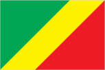
Flag description
divided diagonally from the lower hoist side by a yellow band; the upper triangle (hoist side) is green and the lower triangle is red; green symbolizes agriculture and forests, yellow the friendship and nobility of the people, red is unexplained but has been associated with the struggle for independence uses the popular Pan-African colors of Ethiopia
Government type
republic
Independence
15 August 1960 (from France)
International law organization participation
has not submitted an ICJ jurisdiction declaration; accepts ICCt jurisdiction
International organization participation
ACP, AfDB, AU, BDEAC, CEMAC, EITI (candidate country), FAO, FZ, G-77, IAEA, IBRD, ICAO, ICRM, IDA, IFAD, IFC, IFRCS, ILO, IMF, IMO, Interpol, IOC, IOM, IPU, ISO (correspondent), ITSO, ITU, ITUC (NGOs), MIGA, NAM, OIF, OPCW, UN, UNCTAD, UNESCO, UNHCR, UNIDO, UNITAR, UNWTO, UPU, WCO, WFTU (NGOs), WHO, WIPO, WMO, WTO
Judicial branch
- Supreme Court or Cour Supreme (consists of NA judges) note - the High Court of Justice, outside the judicial authority, tries cases involving treason by the president of the republic judges elected by parliament and serve until retirement age courts of appeal; regional and district courts; employment tribunals; juvenile courts
- highest court(s)
- Supreme Court or Cour Supreme (consists of NA judges)
- judge selection and term of office
- judges elected by parliament and serve until retirement age
- subordinate courts
- courts of appeal; regional and district courts; employment tribunals; juvenile courts
Legal system
mixed legal system of French civil law and customary law
Legislative branch
- bicameral Parliament consists of the Senate (72 seats; members elected by indirect vote to serve five-year terms) and the National Assembly (139 seats; members elected by popular vote to serve six-year terms) Senate - last held on 5 August 2008 (next to be held in July 2014); National Assembly - last held on 15 July and 5 August 2012 (next to be held in 2018) Senate - percent of vote by party - NA; seats by party - RMP 33, FDU 23, UPADS 2, independents 7, other 7; National Assembly - percent of vote by party - NA; seats by party - PCT (and allies) 117, UPADS 7, independents 12, vacant 3
- election results
- Senate - percent of vote by party - NA; seats by party - RMP 33, FDU 23, UPADS 2, independents 7, other 7; National Assembly - percent of vote by party - NA; seats by party - PCT (and allies) 117, UPADS 7, independents 12, vacant 3
- elections
- Senate - last held on 5 August 2008 (next to be held in July 2014); National Assembly - last held on 15 July and 5 August 2012 (next to be held in 2018)
National anthem
- "La Congolaise" (The Congolese) Jacques TONDRA and Georges KIBANGHI/Jean ROYER and Joseph SPADILIERE originally adopted 1959, restored 1991
- lyrics/music
- Jacques TONDRA and Georges KIBANGHI/Jean ROYER and Joseph SPADILIERE
- name
- "La Congolaise" (The Congolese)
National holiday
Independence Day, 15 August (1960)
National symbol(s)
lion; elephant
Political parties and leaders
Action Movement for Renewal or MAR Congolese Labour Party or PCT Congolese Movement for Democracy and Integral Development or MCDDI [Michel MAMPOUYA] Movement for Solidarity and Development or MSD Pan-African Union for Social Development or UPADS [Martin MBERI] Rally for Democracy and the Republic or RDR [Raymond Damasge NGOLLO] Rally for Democracy and Social Progress or RDPS [Jean-Pierre Thystere TCHICAYA, president] Rally of the Presidential Majority or RMP Union for Democracy and Republic or UDR United Democratic Forces or FDU [Sebastian EBAO] many smaller parties
Political pressure groups and leaders
Congolese Trade Union Congress or CSC General Union of Congolese Pupils and Students or UGEEC Revolutionary Union of Congolese Women or URFC Union of Congolese Socialist Youth or UJSC
Suffrage
18 years of age; universal
Economy
Agriculture - products
cassava (tapioca), sugar, rice, corn, peanuts, vegetables, coffee, cocoa; forest products
Budget
- $5.83 billion $4.949 billion (2012 est.)
- expenditures
- $4.949 billion (2012 est.)
- revenues
- $5.83 billion
Budget surplus (+) or deficit (-)
6.5% of GDP (2012 est.)
Central bank discount rate
4.25% (31 December 2009) 4.75% (31 December 2008)
Commercial bank prime lending rate
14.8% (31 December 2012 est.) 15% (31 December 2011 est.)
Current account balance
$187.9 million (2012 est.) $1.003 billion (2011 est.)
Debt - external
$2.999 billion (31 December 2012 est.) $2.523 billion (31 December 2011 est.)
Economy - overview
The economy is a mixture of subsistence hunting and agriculture, an industrial sector based largely on oil and support services, and government spending. Oil has supplanted forestry as the mainstay of the economy, providing a major share of government revenues and exports. Natural gas is increasingly being converted to electricity rather than being flared, greatly improving energy prospects. New mining projects, particularly iron ore, that may enter production as early as late 2013 may add as much as $1 billion to annual government revenue. Economic reform efforts have been undertaken with the support of international organizations, notably the World Bank and the IMF, including recently concluded Article IV consultations. Denis SASSOU-Nguesso, who returned to power when the war ended in October 1997, publicly expressed interest in moving forward on economic reforms and privatization and in renewing cooperation with international financial institutions. Economic progress was badly hurt by slumping oil prices and the resumption of armed conflict in December 1998, which worsened the republic's budget deficit. The current administration faces difficult economic challenges of stimulating recovery and reducing poverty. The drop in oil prices during the global crisis reduced oil revenue by about 30%, but the subsequent recovery of oil prices boosted the economy's GDP from 2009-12. In March 2006, the World Bank and the International Monetary Fund (IMF) approved Heavily Indebted Poor Countries (HIPC) treatment for Congo, which received $1.9 billion in debt relief under the program in 2010. Congo also restructured old defaulted London Club debt in 2007, which effectively cancelled 80% of its private debt. Contracts with China have increased Congo's publicly held debt. Officially the country became a net external creditor as of 2011, with external debt representing less than 22% of GDP and debt servicing less than 3% of government revenue.
Exchange rates
Cooperation Financiere en Afrique Centrale francs (XAF) per US dollar - 510.53 (2012 est.) 471.87 (2011 est.) 495.28 (2010 est.) 472.19 (2009) 447.81 (2008)
Exports
$10.53 billion (2012 est.) $11.13 billion (2011 est.)
Exports - commodities
petroleum, lumber, plywood, sugar, cocoa, coffee, diamonds
Exports - partners
China 39%, US 13%, France 9.5%, Australia 8.8%, Netherlands 6.8%, Spain 5.3%, India 5.2% (2012)
Fiscal year
calendar year
GDP - composition, by end use
- 22.7% 12.5% 53.6% 1% 102.6% -92.4% (2012 est.)
- exports of goods and services
- 102.6%
- government consumption
- 12.5%
- household consumption
- 22.7%
- imports of goods and services
- -92.4%
- investment in fixed capital
- 53.6%
- investment in inventories
- 1%
GDP - composition, by sector of origin
- 3.4% 76.8% 19.9% (2012 est.)
- agriculture
- 3.4%
- industry
- 76.8%
- services
- 19.9% (2012 est.)
GDP - per capita (PPP)
$4,600 (2012 est.) $4,600 (2011 est.) $4,600 (2010 est.) data are in 2012 US dollars
GDP - real growth rate
3.8% (2012 est.) 3.4% (2011 est.) 8.8% (2010 est.)
GDP (official exchange rate)
$13.51 billion (2012 est.)
GDP (purchasing power parity)
$18.89 billion (2012 est.) $18.19 billion (2011 est.) $17.59 billion (2010 est.) data are in 2012 US dollars
Gross national saving
56.2% of GDP (2012 est.) 61.3% of GDP (2011 est.) 46.6% of GDP (2010 est.)
Household income or consumption by percentage share
- 2.1% 37.1% (2005)
- highest 10%
- 37.1% (2005)
- lowest 10%
- 2.1%
Imports
$4.45 billion (2012 est.) $4.501 billion (2011 est.)
Imports - commodities
capital equipment, construction materials, foodstuffs
Imports - partners
France 19.5%, China 13.5%, Brazil 9.1%, US 6.1%, India 5.8%, Italy 4.8%, Belgium 4.4% (2012)
Industrial production growth rate
4% (2012 est.)
Industries
petroleum extraction, cement, lumber, brewing, sugar, palm oil, soap, flour, cigarettes
Inflation rate (consumer prices)
3.9% (2012 est.) 1.3% (2011 est.)
Labor force
2.89 million (2011 est.)
Market value of publicly traded shares
$NA
Population below poverty line
46.5% (2011 est.)
Public debt
31.8% of GDP (2012 est.) 16.9% of GDP (2011 est.)
Reserves of foreign exchange and gold
$5.568 billion (31 December 2012 est.) $5.658 billion (31 December 2011 est.)
Stock of broad money
$3.753 billion (31 December 2011 est.) $2.882 billion (31 December 2010 est.)
Stock of domestic credit
$-1.448 billion (31 December 2012 est.) $-2.392 billion (31 December 2011 est.)
Stock of narrow money
$4.403 billion (31 December 2012 est.) $3.341 billion (31 December 2011 est.)
Taxes and other revenues
43.2% of GDP (2012 est.)
Unemployment rate
53% (2012 est.)
Energy
Carbon dioxide emissions from consumption of energy
6.858 million Mt (2011 est.)
Crude oil - exports
290,000 bbl/day (2011 est.)
Crude oil - imports
0 bbl/day (2011 est.)
Crude oil - production
291,900 bbl/day (2012 est.)
Crude oil - proved reserves
1.6 billion bbl (1 January 2013 es)
Electricity - consumption
588 million kWh (2012 est.)
Electricity - exports
0 kWh (2012 est.)
Electricity - from fossil fuels
51.2% of total installed capacity (2012 est.)
Electricity - from hydroelectric plants
48.8% of total installed capacity (2012 est.)
Electricity - from nuclear fuels
0% of total installed capacity (2012 est.)
Electricity - from other renewable sources
0% of total installed capacity (2012 est.)
Electricity - imports
495 million kWh (2010 est.)
Electricity - installed generating capacity
559,000 kW (2012 est.)
Electricity - production
559 million kWh (2012 est.)
Natural gas - consumption
930 million cu m (2010 est.)
Natural gas - exports
39 million cu m (2012 est.)
Natural gas - imports
0 cu m (2012 est.)
Natural gas - production
946 million cu m (2012 est.)
Natural gas - proved reserves
90.61 billion cu m (1 January 2013 es)
Refined petroleum products - consumption
10,710 bbl/day (2011 est.)
Refined petroleum products - exports
4,288 bbl/day (2010 est.)
Refined petroleum products - imports
4,156 bbl/day (2010 est.)
Refined petroleum products - production
13,820 bbl/day (2010 est.)
Communications
Broadcast media
1 state-owned TV and 3 state-owned radio stations; several privately owned TV and radio stations; satellite TV service is available; rebroadcasts of several international broadcasters are available (2007)
Internet country code
.cg
Internet hosts
45 (2012)
Internet users
245,200 (2009)
Telephone system
- primary network consists of microwave radio relay and coaxial cable with services barely adequate for government use; key exchanges are in Brazzaville, Pointe-Noire, and Loubomo; intercity lines frequently out of order fixed-line infrastructure inadequate providing less than 1 connection per 100 persons; in the absence of an adequate fixed line infrastructure, mobile-cellular subscribership has surged to 90 per 100 persons country code - 242; satellite earth station - 1 Intelsat (Atlantic Ocean) (2011)
- domestic
- fixed-line infrastructure inadequate providing less than 1 connection per 100 persons; in the absence of an adequate fixed line infrastructure, mobile-cellular subscribership has surged to 90 per 100 persons
- general assessment
- primary network consists of microwave radio relay and coaxial cable with services barely adequate for government use; key exchanges are in Brazzaville, Pointe-Noire, and Loubomo; intercity lines frequently out of order
- international
- country code - 242; satellite earth station - 1 Intelsat (Atlantic Ocean) (2011)
Telephones - main lines in use
14,900 (2012)
Telephones - mobile cellular
4.283 million (2012)
Transportation
Airports
27 (2013)
Airports - with paved runways
- 5 (2013)
- 1,524 to 2,437 m
- 5 (2013)
- 2,438 to 3,047 m
- 1
- over 3,047 m
- 2
- total
- 8
Airports - with unpaved runways
- 2 (2013)
- 1,524 to 2,437 m
- 8
- 914 to 1,523 m
- 9
- total
- 19
Merchant marine
- 1 (Democratic Republic of the Congo 1) (2010)
- registered in other countries
- 1 (Democratic Republic of the Congo 1) (2010)
Pipelines
gas 232 km; liquid petroleum gas 4 km; oil 982 km (2013)
Ports and terminals
- Pointe-Noire Brazzaville (Congo); Impfondo (Oubangi); Ouesso (Sangha); Oyo (Alima) Djeno
- major seaport(s)
- Pointe-Noire
- oil/gas terminal(s)
- Djeno
- river port(s)
- Brazzaville (Congo); Impfondo (Oubangi); Ouesso (Sangha); Oyo (Alima)
Railways
- 886 km 886 km 1.067-m gauge (2008)
- total
- 886 km
Roadways
- 17,289 km 864 km 16,425 km (2004)
- total
- 17,289 km
- unpaved
- 16,425 km (2004)
Waterways
1,120 km (commercially navigable on Congo and Oubanqui rivers above Brazzaville; there are many ferries across the river to Kinshasa; the Congo south of Brazzaville-Kinshasa to the coast is not navigable because of rapids, thereby necessitating a rail connection to Pointe Noire; other rivers are used for local traffic only) (2011)
Military and Security
Manpower available for military service
- 928,664 914,265 (2010 est.)
- females age 16-49
- 914,265 (2010 est.)
- males age 16-49
- 928,664
Manpower fit for military service
- 577,944 566,587 (2010 est.)
- females age 16-49
- 566,587 (2010 est.)
- males age 16-49
- 577,944
Manpower reaching militarily significant age annually
- 50,000 49,641 (2010 est.)
- female
- 49,641 (2010 est.)
- male
- 50,000
Military branches
- Congolese Armed Forces (Forces Armees Congolaises, FAC): Army (Armee de Terre), Navy, Congolese Air Force (Armee de l'Air Congolaise); Gendarmerie; Special Presidential Security Guard (GSSP) (2013)
- Congolese Armed Forces (Forces Armees Congolaises, FAC)
- Army (Armee de Terre), Navy, Congolese Air Force (Armee de l'Air Congolaise); Gendarmerie; Special Presidential Security Guard (GSSP) (2013)
Military expenditures
1.7% of GDP (2011)
Military service age and obligation
18 years of age for voluntary military service; women can serve in the Armed Forces (2012)
Transnational Issues
Disputes - international
the location of the boundary in the broad Congo River with the Democratic Republic of the Congo is undefined except in the Pool Malebo/Stanley Pool area
Refugees and internally displaced persons
- 8,404 (Rwanda); 89,424 (Democratic Republic of Congo) (2012) 7,800 (multiple civil wars since 1992) (2009)
- IDPs
- 7,800 (multiple civil wars since 1992) (2009)
- refugees (country of origin)
- 8,404 (Rwanda); 89,424 (Democratic Republic of Congo) (2012)