1989 Edition
CIA World Factbook 1989 (Internet Archive)
Geography
Administrative divisions
9 regions (regions, singular — region); Bouenza, Cuvette, Kouilou, Lekoumou, Likouala, Niari, Plateaux, Pool, Sangha; note — there may be a new capital district of Brazzaville
Capital
Brazzaville
Climate
- tropical; moderated by trade winds
- tropical
Coastline
- 120 km
- 3,095 km
Communists
unknown number of Communists and sympathizers
Comparative area
- slightly less than 1.5 times the size of Washington, DC
- undetermined
Constitution
8 July 1979
Contiguous zone
12 nm
Continental shelf
- 200 meters or edge of continental margin
- 200 meters or to depth of exploitation
Diplomatic representation
Ambassador Benjamin BOUNKOULOU; Chancery at 4891 Colorado Avenue NW, Washington DC 2001 1; telephone (202) 726-5500; US— Ambassador Leonard G. SHURTLEFF; Embassy at Avenue Amilcar Cabral, Brazzaville (mailing address is B. P. 1015, Brazzaville, or Box C, APO New York 09662-0006); telephone 83-20-70 or 83-26-24
Elections
President — last held 26-31 July 1989 (next to be held July 1993); resultsPresident Sassou-Nguesso unanimously reelected leader of the PCT by the Party Congress, which automatically makes him president; People's National Assembly — last held 24 September 1989 (next to be held 1993); results — PCT is the only party; seats — (153 total) single list of candidates nominated by the PCT
Environment
- subject to typhoons from November to March
- subject to occasional tropical cyclones; no permanent fresh water; important nesting area for birds and turtles
Exclusive fishing zone
200 nm
Executive branch
president, prime minister, Council of Ministers (cabinet)
Extended economic zone
200 nm
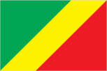
Flag
red with the national emblem in the upper hoist-side corner; the emblem includes a yellow five-pointed star above a crossed hoe and hammer (like the hammer and sickle design) in yellow, flanked by two curved green palm branches; uses the popular pan-African colors of Ethiopia
Independence
1 5 August 1 960 (from France; formerly Congo/ Brazzaville)
Judicial branch
Supreme Court (Cour Supreme)
Land boundaries
- none
- none
Land use
- 4% arable land; 22% permanent crops; 0% meadows and pastures; 0% forest and woodland; 74% other
- 0% arable land; 0% permanent crops; 0% meadows and pastures; 0% forest and woodland; 100% other, mostly grass or scrub cover; Lihou Reef Reserve and Coringa-Herald Reserve were declared National Nature Reserves on 3 August 1982
Leaders
Chief of State and Head of Government— President Denis SASSOU-NGUESSO (since 8 February 1979); Prime Minister Alphonse POATYSOUCHLATY (since 6 August 1989) Political parties and leaders: only party — Congolese Labor Party (PCT), President Denis Sassou-Nguesso, leader
Legal system
based on French civil law system and customary law
Legislative branch
unicameral People's National Assembly (Assemblee Nationale Populaire)
Member of
ACP, AfDB, CCC, Conference of East and Central African States, EAMA, ECA, EIB (associate), FAO, G77, GATT, IBRD, ICAO, ICO, IDA, IFAD, IFC, ILO, IMF, IMO, INTELSAT, INTERPOL, ITU, NAM, OAU, UDEAC, UEAC, UN, UNESCO, UPU, WFTU, WHO, WIPO, WMO
National holiday
National Day, 1 5 August (1960)
Natural resources
- negligible
- negligible
Note
- located 4,500 km south of Hawaii in the South Pacific Ocean
- the islands are located just off the northeast coast of Australia in the Coral Sea
Other political or pressure groups
Union of Congolese Socialist Youth (UJSC), Congolese Trade Union Congress (CSC), Revolutionary Union of Congolese Women (URFC), General Union of Congolese Pupils and Students (UGEEC)
Suffrage
universal at age 18
Terrain
- low coral atolls in north; volcanic, hilly islands in south
- sand and coral reefs and islands (or cays)
Territorial sea
- 1 2 nm
- 3 nm
Total area
- 240 km2; land area: 240 km2
- undetermined; includes numerous small islands and reefs scattered over a sea area of about 1 million km2, with Willis Islets the most important
Type
people's republic
People and Society
Birth rate
22 births/ 1,000 population (1990)
Death rate
7 deaths/ 1 ,000 population (1990)
Ethnic divisions
81.3% Polynesian (full blood), 7.7% Polynesian and European, 7.7% Polynesian and other, 2.4% European, 0.9% other
Infant mortality rate
24 deaths/ 1,000 live births (1990)
Labor force
5,810; agriculture 29%, government 27%, services 25%, industry 1 5%, and other 4% (1981)
Language
English
Life expectancy at birth
66 years male, 72 years female (1990)
Literacy
NA%
Nationality
noun — Cook Islander(s); adjective— Cook Islander
Net migration rate
— 10 migrants/ 1 ,000 population (1990)
Organized labor
NA
Population
- 18,187 (July 1990), growth rate 0.5% (1990)
- 3 meteorologists
Religion
Christian, majority of populace members of Cook Islands Christian Church
Total fertility rate
3.5 children born/ woman (1990)
Government
Administrative divisions
none
Capital
Avarua
Constitution
4 August 1965
Diplomatic representation
none (self-governing in free association with New Zealand)
Elections
Parliament — last held 19 January 1989 (next to be held by January 1 994); results — percent of vote by party NA; seats — (24 total) Cook Islands Party 12, Democratic Tumu Party 2, opposition coalition (including Democratic Party) 9, independent 1
Executive branch
British monarch, representative of the UK, representative of New Zealand, prime minister, deputy prime minister. Cabinet
Flag
- blue with the flag of the UK in the upper hoist-side quadrant and a large circle of 15 white five-pointed stars (one for every island) centered in the outer half of the flag
- the flag of Australia is used
Independence
became self-governing in free association with New Zealand on 4 August 1965 and has the right at any time to move to full independence by unilateral action
Judicial branch
High Court
Leaders
Chief of State— Queen ELIZABETH II (since 6 February 1952); Representative of the UK Sir Tangaroa TANGAROA (since NA); Representative of New Zealand Adrian SINCOCK (since NA); Head of Government — Prime Minister Geoffrey HENRY (since NA February 1989); Deputy Prime Minister Inatio AKARURU (since NA) Political parties and leaders: Cook Islands Party, Geoffrey Henry; Democratic Tumu Party, Vincent Ingram; Democratic Party, Dr. Vincent Pupuke Robati; Cook Islands Labor Party, Rena Jonassen; Cook Islands People's Party, Sadaraka Sadaraka
Legislative branch
unicameral Parliament; note — the unicameral House of Arikis (chiefs) advises on traditional matters, but has no legislative powers
Long-form name
- none
- Coral Sea Islands Territory
Member of
ADB, ESCAP (associate member), IDA, IFC, IMF, SPF
National holiday
NA
Suffrage
universal adult at age NA
Type
- self-governing in free association with New Zealand; Cook Islands fully responsible for internal affairs; New Zealand retains responsibility for external affairs, in consultation with the Cook Islands
- territory of Australia administered by the Minister for Arts, Sport, the Environment, Tourism, and Territories Graham Richardson
Economy
Agriculture
- accounts for 11% of GDP (including fishing and forestry); cassava accounts for 90% of food output; other crops — rice, corn, peanuts, vegetables; cash crops include coffee and cocoa; forest products important export earner; imports over 90% of food needs
- export crops — copra, citrus fruits, pineapples, tomatoes, bananas; subsistence crops — yams, taro
Aid
- US commitments, including Ex-Im (FY70-88), $56 million; Western (non-US) countries, ODA and OOF bilateral commitments (1970-87), $2.1 billion; OPEC bilateral aid (1979-89), $15 million; Communist countries (1970-88), $338 million
- Western (non-US) countries, ODA and OOF bilateral commitments (197089), $128 million
Budget
- revenues $382 million; expenditures $575 million, including capital expenditures of $1 18 million (1988)
- revenues $33.8 million; expenditures $34.4 million, including capital expenditures of $NA (1990 est.)
Currency
- Communaute Financiere Africaine franc (plural — francs); 1 CFA franc (CFAF) = 100 centimes
- New Zealand dollar (plural — dollars); 1 New Zealand dollar (NZ$) = 100 cents
Electricity
- 133,000 kW capacity; 300 million kWh produced, 130 kWh per capita (1989)
- 4,800 kW capacity; 1 5 million kWh produced, 830 kWh per capita (1989)
Exchange rates
- Communaute Financiere Africaine francs (CFAF) per US$1 — 287.99 (January 1990), 319.01 (1989), 297.85 (1988), 300.54 (1987), 346.30 (1986), 449.26 (1985)
- New Zealand dollars (NZ$)per US$1— 1.6581 (January 1990), 1.6708(1989), 1.5244(1988), 1.6886 (1987), 1.9088 (1986), 2.0064(1985)
Exports
- $912 million (f.o.b., 1987); commodities— crude petroleum 72%, lumber, plywood, coffee, cocoa, sugar, diamonds; partners — US, France, other EC
- $4.0 million (f.o.b., 1988); commodities— copra, fresh and canned fruit, clothing; partners — NZ 80%, Japan
External debt
- $4.5 billion (December 1988)
- SNA
Fiscal year
- calendar year
- 1 April-3 1 March
GDP
- $2.2 billion, per capita $1,000; real growth rate -3% (1988 est.)
- $40.0 million, per capita $2,200 (1988 est.); real growth rate 5.3% (1986-88 est.)
Imports
- $494.4 million (c.i.f., 1987); commodities— foodstuffs, consumer goods, intermediate manufactures, capital equipment; partners — France, Italy, other EC, US, FRG, Spain, Japan, Brazil
- $38.7 million (c.i.f., 1988); commodities— foodstuffs, textiles, fuels, timber; partners — NZ 49%, Japan, Australia, US
Industrial production
- growth rate —5.9% (1987)
- growth rate NA%
Industries
- crude oil, cement, sawmills, brewery, sugar mill, palm oil, soap, cigarettes
- fruit processing, tourism
Inflation rate (consumer prices)
- 1.5% (1988)
- 8.0% (1988)
Overview
- Oil has supplanted forestry as the mainstay of the economy, providing about two-thirds of government revenues and exports. In the early 1980s rapidly rising oil revenues enabled Congo to finance large-scale development projects with growth averaging 5% annually, one of the highest rates in Africa. The world decline in oil prices, however, has forced the government to launch an austerity program to cope with declining receipts and mounting foreign debts.
- Agriculture provides the economic base. The major export earners are fruit, copra, and clothing. Manufacturing activities are limited to a fruit-processing plant and several clothing factories. Economic development is hindered by the isolation of the islands from foreign markets and a lack of natural resources and good transportation links. A large trade deficit is annually made up for by remittances from emigrants and from foreign aid. Current economic development plans call for exploiting the tourism potential and expanding the fishing industry.
- no economic activity
Unemployment rate
- NA%
- NA%
Communications
Airports
- 51 total, 46 usable; 5 with permanent-surface runways; none with runways over 3,659 m; 1 with runways 2,440-3,659 m; 17 with runways 1,2202,439 m
- 7 total, 5 usable; 1 with permanent-surface runways; none with runways over 2,439 m; 3 with runways 1, 220-2,439 m
Branches
Army, Navy, Air Force, paramilitary National People's Militia Military manpower males 15-49, 492,419; 250,478 fit for military service; 23,622 reach military age (20) annually
Civil air
- 4 major transport aircraft
- no major transport aircraft Coral Sea Islands (territory of Australia)
Defense expenditures
4.6% of GDP (1987) Cook Islands (free association with New Zealand) Rakahanga Panrhyn Pukapuka Manihiki Nassau Island Suwarrow South Pacific Ocean Palmarston Ailulaki . Mitiaro Takutta Mauke 400km •- *AVARUA Rarotonga Nee re Rionil map X Mangaia
Highways
- 12,000 km total; 560 km bituminous surface treated; 850 km gravel, laterite; 5,350 km improved earth; 5,240 km unimproved roads
- 187 km total (1980); 35 km paved, 35 km gravel, 84 km improved earth, 33 km unimproved earth
Inland waterways
the Congo and Ubangi (Oubangui) Rivers provide 1,120 km of commercially navigable water transport; the rest are used for local traffic only
Note
- defense is the responsibility of New Zealand 400km ..Bougainville Reef p. Qwillis Islets • Coringa Islets ^.LihouReef Me/lish^ Coral Sea Frederick fleets ^ Wreck Reef. . Cato Island*
- defense is the responsibility of Australia; visited regularly by the Royal Australian Navy; Australia has control over the activities of visitors Sec regional map X
Pipelines
crude oil 25 km
Ports
- Pointe-Noire (ocean port), Brazzaville (river port)
- Avatiu
- none; offshore anchorages only Defense Forces
Railroads
797 km, 1 .067-meter gauge, single track (includes 285 km that are privately owned)
Telecommunications
- services adequate for government use; primary network is composed of radio relay routes and coaxial cables; key centers are Brazzaville, PointeNoire, and Loubomo; 18,100 telephones; stations— 3 AM, 1 FM, 4 TV; 1 Atlantic Ocean satellite station Defense Forces
- stations — 2 AM, no FM, no TV; 10,000 radio receivers; 2,052 telephones; 1 Pacific Ocean INTELSAT earth station Defense Forces