2014 Edition
CIA World Factbook 2014 Archive (HTML)
Introduction
Background
Comoros has endured more than 20 coups or attempted coups since gaining independence from France in 1975. In 1997, the islands of Anjouan and Moheli declared independence from Comoros. In 1999, military chief Col. AZALI seized power of the entire government in a bloodless coup, and helped negotiate the 2000 Fomboni Accords power-sharing agreement in which the federal presidency rotates among the three islands, and each island maintains its local government. AZALI won the 2002 federal presidential election, and each island in the archipelago elected its president. AZALI stepped down in 2006 and President SAMBI was elected to office. In 2007, Mohamed BACAR effected Anjouan's de-facto secession from the Union of Comoros, refusing to step down when Comoros' other islands held legitimate elections in July. The African Union (AU) initially attempted to resolve the political crisis by applying sanctions and a naval blockade to Anjouan, but in March 2008 the AU and Comoran soldiers seized the island. The island's inhabitants generally welcomed the move. In May 2011, Ikililou DHOININE won the presidency in peaceful elections widely deemed to be free and fair.
Geography
Area
- 2,235 sq km 2,235 sq km 0 sq km
- total
- 2,235 sq km
- water
- 0 sq km
Area - comparative
slightly more than 12 times the size of Washington, DC
Climate
tropical marine; rainy season (November to May)
Coastline
340 km
Elevation extremes
- Indian Ocean 0 m Karthala 2,360 m
- highest point
- Karthala 2,360 m
- lowest point
- Indian Ocean 0 m
Environment - current issues
soil degradation and erosion results from crop cultivation on slopes without proper terracing; deforestation
Environment - international agreements
- Biodiversity, Climate Change, Climate Change-Kyoto Protocol, Desertification, Endangered Species, Hazardous Wastes, Law of the Sea, Ozone Layer Protection, Ship Pollution, Wetlands none of the selected agreements
- party to
- Biodiversity, Climate Change, Climate Change-Kyoto Protocol, Desertification, Endangered Species, Hazardous Wastes, Law of the Sea, Ozone Layer Protection, Ship Pollution, Wetlands
- signed, but not ratified
- none of the selected agreements
Freshwater withdrawal (domestic/industrial/agricultural)
- 0.01 cu km/yr (48%/5%/47%) 16.86 cu m/yr (1999)
- per capita
- 16.86 cu m/yr (1999)
- total
- 0.01 cu km/yr (48%/5%/47%)
Geographic coordinates
12 10 S, 44 15 E
Geography - note
important location at northern end of Mozambique Channel
Irrigated land
1.3 sq km NA (2003)
Land boundaries
0 km
Land use
- 44.06% 31.17% 24.77% (2011)
- arable land
- 44.06%
- other
- 24.77% (2011)
- permanent crops
- 31.17%
Location
Southern Africa, group of islands at the northern mouth of the Mozambique Channel, about two-thirds of the way between northern Madagascar and northern Mozambique
Map references
Africa
Maritime claims
- 12 nm 200 nm
- exclusive economic zone
- 200 nm
- territorial sea
- 12 nm
Natural hazards
- cyclones possible during rainy season (December to April); volcanic activity on Grand Comore Karthala (elev. 2,361 m) on Grand Comore Island last erupted in 2007; a 2005 eruption forced thousands of people to be evacuated and produced a large ash cloud
- volcanism
- Karthala (elev. 2,361 m) on Grand Comore Island last erupted in 2007; a 2005 eruption forced thousands of people to be evacuated and produced a large ash cloud
Natural resources
NEGL
Terrain
volcanic islands, interiors vary from steep mountains to low hills
Total renewable water resources
1.2 cu km (2011)
People and Society
Age structure
- 41.3% (male 157,996/female 159,088) 18.8% (male 69,688/female 74,418) 31.9% (male 116,235/female 128,647) 4.1% (male 14,074/female 17,700) 3.7% (male 13,696/female 15,323) (2014 est.)
- 0-14 years
- 41.3% (male 157,996/female 159,088)
- 15-24 years
- 18.8% (male 69,688/female 74,418)
- 25-54 years
- 31.9% (male 116,235/female 128,647)
- 55-64 years
- 4.1% (male 14,074/female 17,700)
- 65 years and over
- 3.7% (male 13,696/female 15,323) (2014 est.)
Birth rate
29.05 births/1,000 population (2014 est.)
Child labor - children ages 5-14
- 39,550 27 % (2000 est.)
- percentage
- 27 % (2000 est.)
- total number
- 39,550
Children under the age of 5 years underweight
25% (2000)
Contraceptive prevalence rate
25.7% (2000)
Death rate
7.76 deaths/1,000 population (2014 est.)
Dependency ratios
- 81 % 75.9 % 5.1 % 19.5 (2014 est.)
- elderly dependency ratio
- 5.1 %
- potential support ratio
- 19.5 (2014 est.)
- total dependency ratio
- 81 %
- youth dependency ratio
- 75.9 %
Drinking water source
- rural: 96.7% of population rural: 3.3% of population (2012 est.)
- rural
- 3.3% of population (2012 est.)
Education expenditures
7.6% of GDP (2008)
Ethnic groups
Antalote, Cafre, Makoa, Oimatsaha, Sakalava
Health expenditures
5.3% of GDP (2011)
HIV/AIDS - adult prevalence rate
0.1% (2009 est.)
HIV/AIDS - deaths
fewer than 100 (2009 est.)
HIV/AIDS - people living with HIV/AIDS
fewer than 500 (2009 est.)
Hospital bed density
2.2 beds/1,000 population (2006)
Infant mortality rate
- 65.31 deaths/1,000 live births 76.11 deaths/1,000 live births 54.18 deaths/1,000 live births (2014 est.)
- female
- 54.18 deaths/1,000 live births (2014 est.)
- total
- 65.31 deaths/1,000 live births
Languages
Arabic (official), French (official), Shikomoro (a blend of Swahili and Arabic)
Life expectancy at birth
- 63.48 years 61.23 years 65.8 years (2014 est.)
- female
- 65.8 years (2014 est.)
- total population
- 63.48 years
Literacy
- age 15 and over can read and write 75.5% 80.5% 70.6% (2011 est.)
- definition
- age 15 and over can read and write
- female
- 70.6% (2011 est.)
- male
- 80.5%
- total population
- 75.5%
Major urban areas - population
MORONI (capital) 54,000 (2011)
Maternal mortality rate
280 deaths/100,000 live births (2010)
Median age
- 19.2 years 18.5 years 19.8 years (2014 est.)
- female
- 19.8 years (2014 est.)
- male
- 18.5 years
- total
- 19.2 years
Mother's mean age at first birth
24.6 median age at first birth among women 25-29 (2012 est.)
Nationality
- Comoran(s) Comoran
- adjective
- Comoran
- noun
- Comoran(s)
Net migration rate
-2.58 migrant(s)/1,000 population (2014 est.)
Obesity - adult prevalence rate
4.4% (2008)
Physicians density
0.15 physicians/1,000 population (2004)
Population
766,865 (July 2014 est.)
Population growth rate
1.87% (2014 est.)
Religions
Sunni Muslim 98%, Roman Catholic 2%
Sanitation facility access
- urban: 50% of population rural: 29.7% of population total: 35.4% of population urban: 50% of population rural: 70.3% of population total: 64.6% of population (2010 est.)
- rural
- 70.3% of population
- total
- 64.6% of population (2010 est.)
- urban
- 50% of population
School life expectancy (primary to tertiary education)
- 13 years 13 years 12 years (2012)
- female
- 12 years (2012)
- male
- 13 years
- total
- 13 years
Sex ratio
- 1.03 male(s)/female 0.99 male(s)/female 0.94 male(s)/female 0.9 male(s)/female 0.94 male(s)/female 0.92 male(s)/female 0.94 male(s)/female (2014 est.)
- 0-14 years
- 0.99 male(s)/female
- 15-24 years
- 0.94 male(s)/female
- 25-54 years
- 0.9 male(s)/female
- 55-64 years
- 0.94 male(s)/female
- 65 years and over
- 0.92 male(s)/female
- at birth
- 1.03 male(s)/female
- total population
- 0.94 male(s)/female (2014 est.)
Total fertility rate
3.76 children born/woman (2014 est.)
Urbanization
- 28% of total population (2011) 2.84% annual rate of change (2010-15 est.)
- rate of urbanization
- 2.84% annual rate of change (2010-15 est.)
- urban population
- 28% of total population (2011)
Government
Administrative divisions
3 islands and 4 municipalities*; Anjouan (Ndzuwani), Domoni*, Fomboni*, Grande Comore (N'gazidja), Moheli (Mwali), Moroni*, Moutsamoudou*
Capital
- Moroni 11 42 S, 43 14 E UTC+3 (8 hours ahead of Washington, DC, during Standard Time)
- geographic coordinates
- 11 42 S, 43 14 E
- name
- Moroni
- time difference
- UTC+3 (8 hours ahead of Washington, DC, during Standard Time)
Constitution
previous 1996; latest ratified 23 December 2001; amended 2009 and 2014 (2014)
Country name
- Union of the Comoros Comoros Udzima wa Komori (Comorian); Union des Comores (French); Jumhuriyat al Qamar al Muttahidah (Arabic) Komori (Comorian); Comores (French); Juzur al Qamar (Arabic)
- conventional long form
- Union of the Comoros
- conventional short form
- Comoros
- local long form
- Udzima wa Komori (Comorian); Union des Comores (French); Jumhuriyat al Qamar al Muttahidah (Arabic)
- local short form
- Komori (Comorian); Comores (French); Juzur al Qamar (Arabic)
Diplomatic representation from the US
the US does not have an embassy in Comoros; the ambassador to Madagascar is accredited to Comoros
Diplomatic representation in the US
- Ambassador Roubani KAAMBI (since 6 September 2012); note - also serves as Permanent Representative to the UN Mission to the US, 866 United Nations Plaza, Suite 418, New York, NY 10017 [1] (212) 750-1637 [1] (212) 750-1657
- chancery
- Mission to the US, 866 United Nations Plaza, Suite 418, New York, NY 10017
- chief of mission
- Ambassador Roubani KAAMBI (since 6 September 2012); note - also serves as Permanent Representative to the UN
- FAX
- [1] (212) 750-1657
- telephone
- [1] (212) 750-1637
Executive branch
- President Ikililou DHOININE (since 26 May 2011) President Ikililou DHOININE (since 26 May 2011) Council of Ministers appointed by the president as defined by the 2001 constitution, the presidency rotates every four years among the elected presidents from the three main islands in the Union; election last held on 7 November and 26 December 2010 (next to be held in 2015) Ikililou DHOININE elected president; percent of vote - Ikililou DHOININE 61.1%, Mohamed Said FAZUL 32.7%, Abdou DJABIR 6.2%
- cabinet
- Council of Ministers appointed by the president
- chief of state
- President Ikililou DHOININE (since 26 May 2011)
- election results
- Ikililou DHOININE elected president; percent of vote - Ikililou DHOININE 61.1%, Mohamed Said FAZUL 32.7%, Abdou DJABIR 6.2%
- elections
- as defined by the 2001 constitution, the presidency rotates every four years among the elected presidents from the three main islands in the Union; election last held on 7 November and 26 December 2010 (next to be held in 2015)
- head of government
- President Ikililou DHOININE (since 26 May 2011)
Flag description
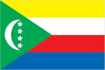
four equal horizontal bands of yellow (top), white, red, and blue, with a green isosceles triangle based on the hoist; centered within the triangle is a white crescent with the convex side facing the hoist and four white, five-pointed stars placed vertically in a line between the points of the crescent; the horizontal bands and the four stars represent the four main islands of the archipelago - Mwali, N'gazidja, Ndzuwani, and Mahore (Mayotte - department of France, but claimed by Comoros) the crescent, stars, and color green are traditional symbols of Islam
Government type
republic
Independence
6 July 1975 (from France)
International law organization participation
has not submitted an ICJ jurisdiction declaration; accepts ICCt jurisdiction
International organization participation
ACP, AfDB, AMF, AOSIS, AU, CAEU (candidates), COMESA, FAO, FZ, G-77, IBRD, ICAO, ICRM, IDA, IDB, IFAD, IFC, IFRCS, ILO, IMF, IMO, IMSO, InOC, Interpol, IOC, IOM, ITSO, ITU, ITUC (NGOs), LAS, NAM, OIC, OIF, OPCW, UN, UNCTAD, UNESCO, UNIDO, UPU, WCO, WHO, WIPO, WMO, WTO (observer)
Judicial branch
- Supreme Court or Cour Supreme (consists of 7 judges); Constitutional Court (consists of 8 members) Supreme Court judges selected - 2 by the president of the Union, 2 by the Assembly of the Union, and 1 each by the 3 island councils; judges appointed for life; Constitutional Court members appointed - 1 by the president, 1 each by the 3 vice presidents, 1 by the Assembly, and 1 each by the island executives; all members serve 6-year renewable terms Court of Appeals (in Moroni); Tribunal de premiere; island village (community) courts; religious courts
- highest court(s)
- Supreme Court or Cour Supreme (consists of 7 judges); Constitutional Court (consists of 8 members)
- judge selection and term of office
- Supreme Court judges selected - 2 by the president of the Union, 2 by the Assembly of the Union, and 1 each by the 3 island councils; judges appointed for life; Constitutional Court members appointed - 1 by the president, 1 each by the 3 vice presidents, 1 by the Assembly, and 1 each by the island executives; all members serve 6-year renewable terms
- subordinate courts
- Court of Appeals (in Moroni); Tribunal de premiere; island village (community) courts; religious courts
Legal system
mixed legal system of Islamic religious law, the French civil code of 1975, and customary law
Legislative branch
- unicameral Assembly of the Union (33 seats; 15 deputies are selected by the individual islands' local assemblies and 18 by universal suffrage to serve for five years); last held on 6 and 20 December 2009 (next to be held in 2014) percent of vote by party - NA; seats by party - pro-union coalition 19, autonomous coalition 4, independents 1; note - 9 additional seats are filled by deputies from local island assemblies
- election results
- percent of vote by party - NA; seats by party - pro-union coalition 19, autonomous coalition 4, independents 1; note - 9 additional seats are filled by deputies from local island assemblies
- elections
- last held on 6 and 20 December 2009 (next to be held in 2014)
National anthem
- "Udzima wa ya Masiwa" (The Union of the Great Islands) Said Hachim SIDI ABDEREMANE/Said Hachim SIDI ABDEREMANE and Kamildine ABDALLAH adopted 1978
- lyrics/music
- Said Hachim SIDI ABDEREMANE/Said Hachim SIDI ABDEREMANE and Kamildine ABDALLAH
- name
- "Udzima wa ya Masiwa" (The Union of the Great Islands)
National holiday
Independence Day, 6 July (1975)
National symbol(s)
four stars and crescent
Political parties and leaders
Camp of the Autonomous Islands or CdIA (a coalition of parties organized by the islands' presidents in opposition to the Union President) Convention for the Renewal of the Comoros or CRC [AZALI Assowmani] Front National pour la Justice or FNJ [Ahmed RACHID] (Islamic party in opposition) Mouvement pour la Democratie et le Progress or MDP-NGDC [Abbas DJOUSSOUF] Parti Comorien pour la Democratie et le Progress or PCDP [Ali MROUDJAE] Rassemblement National pour le Development or RND [Omar TAMOU, Abdoulhamid AFFRAITANE]
Political pressure groups and leaders
- environmentalists
- other
- environmentalists
Suffrage
18 years of age; universal
Economy
Agriculture - products
vanilla, cloves, ylang-ylang (perfume essence), copra, coconuts, bananas, cassava (manioc)
Budget
- $170.1 million $167.4 million (2013 est.)
- expenditures
- $167.4 million (2013 est.)
- revenues
- $170.1 million
Budget surplus (+) or deficit (-)
0.4% of GDP (2013 est.)
Central bank discount rate
1.93% (31 December 2010 est.) 2.21% (31 December 2009 est.)
Commercial bank prime lending rate
9% (31 December 2013 est.) 10.5% (31 December 2012 est.)
Current account balance
-$45.2 million (2013 est.) -$40.9 million (2012 est.)
Debt - external
$142.9 million (31 December 2013 est.) $136.1 million (31 December 2012 est.)
Economy - overview
One of the world's poorest countries, Comoros is made up of three islands that have inadequate transportation links, a young and rapidly increasing population, and few natural resources. The low educational level of the labor force contributes to a subsistence level of economic activity, high unemployment, and a heavy dependence on foreign grants and technical assistance. Agriculture, including fishing, hunting, and forestry, contributes 50% to GDP, employs 80% of the labor force, and provides most of the exports. Export income is heavily reliant on the three main crops of vanilla, cloves, and ylang-ylang; and Comoros' export earnings are easily disrupted by disasters such as fires. The country is not self-sufficient in food production; rice, the main staple, accounts for the bulk of imports. The government - which is hampered by internal political disputes - lacks a comprehensive strategy to attract foreign investment and is struggling to upgrade education and technical training, privatize commercial and industrial enterprises, improve health services, diversify exports, promote tourism, and reduce the high population growth rate. Political problems have inhibited growth. Remittances from 200,000 Comorans abroad help supplement GDP. In December 2012, IMF and the World Bank's International Development Association supported $176 million in debt relief for Comoros, resulting in a 59% reduction of its future external debt service over a period of 40 years.
Exchange rates
Comoran francs (KMF) per US dollar - 378.7 (2013 est.) 382.9 (2012 est.) 371.46 (2010 est.)
Exports
$19.7 million (2013 est.) $19.6 million (2012 est.)
Exports - commodities
vanilla, ylang-ylang (perfume essence), cloves, copra
Exports - partners
Netherlands 58.6%, Singapore 10.6%, Turkey 9.3%, France 5.6%, India 5% (2012)
Fiscal year
calendar year
GDP - composition, by end use
- 97.2% 17.4% 21.6% 5.1% 15% -56.4% (2013 est.)
- exports of goods and services
- 15%
- government consumption
- 17.4%
- household consumption
- 97.2%
- imports of goods and services
- -56.4%
- investment in fixed capital
- 21.6%
- investment in inventories
- 5.1%
GDP - composition, by sector of origin
- 51% 10% 39% (2012 est.)
- agriculture
- 51%
- industry
- 10%
- services
- 39% (2012 est.)
GDP - per capita (PPP)
$1,300 (2013 est.) $1,300 (2012 est.) $1,300 (2011 est.) data are in 2013 US dollars
GDP - real growth rate
3.5% (2013 est.) 3% (2012 est.) 2.2% (2011 est.)
GDP (official exchange rate)
$658 million (2013 est.)
GDP (purchasing power parity)
$911 million (2013 est.) $879.9 million (2012 est.) $855.1 million (2011 est.) data are in 2013 US dollars
Household income or consumption by percentage share
- 0.9% 55.2% (2004)
- highest 10%
- 55.2% (2004)
- lowest 10%
- 0.9%
Imports
$208.8 million (2013 est.) $208 million (2012 est.)
Imports - commodities
rice and other foodstuffs, consumer goods, petroleum products, cement, transport equipment
Imports - partners
Pakistan 15.7%, France 14.2%, UAE 11.5%, India 8.5%, China 6.7%, Kenya 5.3%, Singapore 5.2% (2012)
Industrial production growth rate
4% (2013 est.)
Industries
fishing, tourism, perfume distillation
Inflation rate (consumer prices)
2.5% (2013 est.) 6.3% (2012 est.)
Labor force
233,500 (2011 est.)
Labor force - by occupation
- 80% 20% (1996 est.)
- agriculture
- 80%
- industry and services
- 20% (1996 est.)
Population below poverty line
60% (2002 est.)
Stock of broad money
$261.6 million (31 December 2013 est.) $234.4 million (31 December 2012 est.)
Stock of domestic credit
$156.8 million (31 December 2013 est.) $132.4 million (31 December 2012 est.)
Stock of narrow money
$162.2 million (31 December 2013 est.) $151.6 million (31 December 2012 est.)
Taxes and other revenues
25.8% of GDP (2013 est.)
Unemployment rate
20% (1996 est.)
Energy
Carbon dioxide emissions from consumption of energy
148,400 Mt (2011 est.)
Crude oil - exports
0 bbl/day (2010 est.)
Crude oil - imports
0 bbl/day (2010 est.)
Crude oil - production
0 bbl/day (2012 est.)
Crude oil - proved reserves
0 bbl (1 January 2013 est.)
Electricity - consumption
37.2 million kWh (2010 est.)
Electricity - exports
0 kWh (2012 est.)
Electricity - from fossil fuels
83.3% of total installed capacity (2010 est.)
Electricity - from hydroelectric plants
16.7% of total installed capacity (2010 est.)
Electricity - from nuclear fuels
0% of total installed capacity (2010 est.)
Electricity - from other renewable sources
0% of total installed capacity (2010 est.)
Electricity - imports
0 kWh (2012 est.)
Electricity - installed generating capacity
6,000 kW (2010 est.)
Electricity - production
40 million kWh (2010 est.)
Natural gas - consumption
0 cu m (2010 est.)
Natural gas - exports
0 cu m (2011 est.)
Natural gas - imports
0 cu m (2011 est.)
Natural gas - production
0 cu m (2011 est.)
Natural gas - proved reserves
0 cu m (1 January 2013 est.)
Refined petroleum products - consumption
1,025 bbl/day (2011 est.)
Refined petroleum products - exports
0 bbl/day (2010 est.)
Refined petroleum products - imports
877 bbl/day (2010 est.)
Refined petroleum products - production
0 bbl/day (2010 est.)
Communications
Broadcast media
national state-owned TV station and a TV station run by Anjouan regional government; national state-owned radio; regional governments on the islands of Grande Comore and Anjouan each operate a radio station; a few independent and small community radio stations operate on the islands of Grande Comore and Moheli, and these two islands have access to Mayotte Radio and French TV (2007)
Internet country code
.km
Internet hosts
14 (2012)
Internet users
24,300 (2009)
Telephone system
- sparse system of microwave radio relay and HF radiotelephone communication stations fixed-line connections only about 3 per 100 persons; mobile cellular usage about 30 per 100 persons country code - 269; landing point for the EASSy fiber-optic submarine cable system connecting East Africa with Europe and North America; HF radiotelephone communications to Madagascar and Reunion (2010)
- domestic
- fixed-line connections only about 3 per 100 persons; mobile cellular usage about 30 per 100 persons
- general assessment
- sparse system of microwave radio relay and HF radiotelephone communication stations
- international
- country code - 269; landing point for the EASSy fiber-optic submarine cable system connecting East Africa with Europe and North America; HF radiotelephone communications to Madagascar and Reunion (2010)
Telephones - main lines in use
24,000 (2012)
Telephones - mobile cellular
250,000 (2012)
Transportation
Airports
4 (2013)
Airports - with paved runways
- 3 (2013)
- 2,438 to 3,047 m
- 1
- 914 to 1,523 m
- 3 (2013)
- total
- 4
Merchant marine
- bulk carrier 16, cargo 83, carrier 5, chemical tanker 5, container 2, passenger 2, passenger/cargo 1, petroleum tanker 17, refrigerated cargo 10, roll on/roll off 8 73 (Bangladesh 1, Bulgaria 4, China 1, Cyprus 2, Greece 4, Kenya 2, Kuwait 1, Latvia 2, Lebanon 2, Lithuania 1, Nigeria 1, Norway 1, Pakistan 5, Russia 12, Syria 5, Turkey 8, UAE 8, UK 1, Ukraine 10, US 2) (2010)
- foreign-owned
- 73 (Bangladesh 1, Bulgaria 4, China 1, Cyprus 2, Greece 4, Kenya 2, Kuwait 1, Latvia 2, Lebanon 2, Lithuania 1, Nigeria 1, Norway 1, Pakistan 5, Russia 12, Syria 5, Turkey 8, UAE 8, UK 1, Ukraine 10, US 2) (2010)
- total
- 149
Ports and terminals
- Moroni, Mutsamudu
- major seaport(s)
- Moroni, Mutsamudu
Roadways
- 880 km 673 km 207 km (2002)
- total
- 880 km
- unpaved
- 207 km (2002)
Military and Security
Manpower available for military service
- 184,236 183,363 (2010 est.)
- females age 16-49
- 183,363 (2010 est.)
- males age 16-49
- 184,236
Manpower fit for military service
- 134,562 145,797 (2010 est.)
- females age 16-49
- 145,797 (2010 est.)
- males age 16-49
- 134,562
Manpower reaching militarily significant age annually
- 8,831 8,809 (2010 est.)
- female
- 8,809 (2010 est.)
- male
- 8,831
Military branches
- Army of National Development (l'Armee du Developpement Nationale, AND): Comoran Security Force (also called Comoran Defense Force (Force Comorienne de Defense, FCD), includes Gendarmerie), Comoran Coast Guard, Comoran Federal Police (2013)
- Army of National Development (l'Armee du Developpement Nationale, AND)
- Comoran Security Force (also called Comoran Defense Force (Force Comorienne de Defense, FCD), includes Gendarmerie), Comoran Coast Guard, Comoran Federal Police (2013)
Military service age and obligation
18 years of age for 2-year voluntary military service; no conscription; women first inducted into the Army in 2004 (2012)
Transnational Issues
Disputes - international
claims French-administered Mayotte and challenges France's and Madagascar's claims to Banc du Geyser, a drying reef in the Mozambique Channel; in May 2008, African Union forces were called in to assist the Comoros military recapture Anjouan Island from rebels who seized it in 2001
Trafficking in persons
- Comoros is a source country for children subjected to forced labor and reportedly sex trafficking; Comoran children are forced to labor within the country in domestic service, roadside and street vending, baking, agriculture, and sometimes criminal activities; some Comoran students at Koranic schools are exploited for forced agricultural or domestic labor, sometimes being subjected to physical and sexual abuse; Comoros may be particularly vulnerable to transnational trafficking because of inadequate border controls, government corruption, and the presence of criminal networks Tier 2 Watch List - Comoros does not comply fully with the minimum standards for the elimination of trafficking; however, it is making significant efforts to do so; although the government provided some funding to UNICEF-supported, NGO-run centers, victim protection provisions remained very modest; the government relies on donor funding and international organization partners for the majority of its anti-trafficking efforts; a new law was passed prohibiting child trafficking and the penal code was revised to include prohibitions against and penalties for human trafficking, but these modifications await parliamentary adoption (2013)
- current situation
- Comoros is a source country for children subjected to forced labor and reportedly sex trafficking; Comoran children are forced to labor within the country in domestic service, roadside and street vending, baking, agriculture, and sometimes criminal activities; some Comoran students at Koranic schools are exploited for forced agricultural or domestic labor, sometimes being subjected to physical and sexual abuse; Comoros may be particularly vulnerable to transnational trafficking because of inadequate border controls, government corruption, and the presence of criminal networks
- tier rating
- Tier 2 Watch List - Comoros does not comply fully with the minimum standards for the elimination of trafficking; however, it is making significant efforts to do so; although the government provided some funding to UNICEF-supported, NGO-run centers, victim protection provisions remained very modest; the government relies on donor funding and international organization partners for the majority of its anti-trafficking efforts; a new law was passed prohibiting child trafficking and the penal code was revised to include prohibitions against and penalties for human trafficking, but these modifications await parliamentary adoption (2013)