1996 Edition
CIA World Factbook 1996 (Project Gutenberg)
Introduction
Description
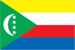
green with a white crescent in the center of the field, its points facing downward; there are four white five-pointed stars placed in a line between the points of the crescent; the crescent, stars, and color green are traditional symbols of Islam; the four stars represent the four main islands of the archipelago - Mwali, Njazidja, Nzwani, and Mayotte (a territorial collectivity of France, but claimed by Comoros); the design, the most recent of several, is described in the constitution approved by referendum on 7 June 1992
Location
12 10 S, 44 15 E -- Southern Africa, group of islands in the Mozambique Channel, about two-thirds of the way between northern Madagascar and northern Mozambique Flag ----
Geography
Area
- comparative area
- slightly more than 12 times the size of Washington, DC
- land area
- 2,170 sq km
- total area
- 2,170 sq km
Climate
tropical marine; rainy season (November to May)
Coastline
340 km
Environment
- current issues
- soil degradation and erosion results from crop cultivation on slopes without proper terracing; deforestation
- international agreements
- party to - Biodiversity, Climate Change, Endangered Species, Hazardous Wastes, Law of the Sea, Ozone Layer Protection; signed, but not ratified - Desertification
- natural hazards
- cyclones and tsunamis possible during rainy season (December to April); Mount Kartala on Grand Comore is an active volcano
Geographic coordinates
12 10 S, 44 15 E
Geographic note
important location at northern end of Mozambique Channel
International disputes
claims French-administered Mayotte
Irrigated land
NA sq km
Land boundaries
0 km
Land use
- arable land
- 35%
- forest and woodland
- 16%
- meadows and pastures
- 7%
- other
- 34%
- permanent crops
- 8%
Location
Southern Africa, group of islands in the Mozambique Channel, about two-thirds of the way between northern Madagascar and northern Mozambique
Map references
Africa
Maritime claims
- exclusive economic zone
- 200 nm
- territorial sea
- 12 nm
Natural resources
negligible
Terrain
- volcanic islands, interiors vary from steep mountains to low hills
- highest point
- Mount Kartala 2,360 m
- lowest point
- Indian Ocean 0 m
People and Society
Age structure
0-14 years: 48% (male 137,235; female 136,207) 15-64 years: 49% (male 138,447; female 142,058) 65 years and over: 3% (male 7,242; female 8,048) (July 1996 est.)
Birth rate
45.82 births/1,000 population (1996 est.)
Death rate
10.28 deaths/1,000 population (1996 est.)
Ethnic divisions
Antalote, Cafre, Makoa, Oimatsaha, Sakalava
Infant mortality rate
75.3 deaths/1,000 live births (1996 est.)
Languages
Arabic (official), French (official), Comoran (a blend of Swahili and Arabic)
Life expectancy at birth
- female
- 61.05 years (1996 est.)
- male
- 56.43 years
- total population
- 58.7 years
Literacy
- age 15 and over can read and write (1995 est.)
- female
- 50.4%
- male
- 64.2%
- total population
- 57.3%
Nationality
- adjective
- Comoran
- noun
- Comoran(s)
Net migration rate
0 migrant(s)/1,000 population (1996 est.)
Population
569,237 (July 1996 est.)
Population growth rate
3.55% (1996 est.)
Religions
Sunni Muslim 86%, Roman Catholic 14%
Sex ratio
- all ages
- 0.99 male(s)/female (1996 est.)
- at birth
- 1.03 male(s)/female
- under 15 years
- 1.01 male(s)/female 15-64 years: 0.98 male(s)/female 65 years and over: 0.9 male(s)/female
Total fertility rate
6.65 children born/woman (1996 est.)
Government
Administrative divisions
- three islands; Grand Comore (Njazidja), Anjouan (Nzwani), and Moheli (Mwali)
- note
- there are also four municipalities named Domoni, Fomboni, Moroni, and Mutsamudu
Capital
Moroni
Constitution
7 June 1992
Data code
CN
Diplomatic representation in US
- chancery
- (temporary) care of the Permanent Mission of the Federal and Islamic Republic of the Comoros to the United Nations, 336 East 45th Street, 2nd Floor, New York, NY 10017
- chief of mission
- Ambassador Mohamed Ahamada DJIMBANAOU (ambassador to the US and Canada)
- telephone
- [1] (212) 972-8010
Executive branch
- cabinet
- Council of Ministers appointed by the president
- chief of state
- President Mohamed TAKI Abdulkarim (since 16 March 1996) was elected by popular vote; election last held 16 March 1996 (next to be held March 2001)
- head of government
- Prime Minister MASSOUNDI Tadjidine Ben Said (since March 1996) was appointed by the president
FAX
[1] (212) 983-4712
Federal Assembly (Assemblee Federale)
- elections last held 12-20 December 1993 (next to be held by NA January 1998); results - percent of vote by party NA; seats - (42 total) ruling coalition: RDR 15, UNDC 5, MWANGAZA 2; opposition: UDZIMA 8; other smaller
- parties
- 10; two seats remained unfilled
Flag
green with a white crescent in the center of the field, its points facing downward; there are four white five-pointed stars placed in a line between the points of the crescent; the crescent, stars, and color green are traditional symbols of Islam; the four stars represent the four main islands of the archipelago - Mwali, Njazidja, Nzwani, and Mayotte (a territorial collectivity of France, but claimed by Comoros); the design, the most recent of several, is described in the constitution approved by referendum on 7 June 1992
Independence
6 July 1975 (from France)
International organization participation
ACCT, ACP, AfDB, AL, CCC, ECA, FAO, FZ, G-77, IBRD, ICAO, IDA, IDB, IFAD, IFC, ILO, IMF, Intelsat (nonsignatory user), IOC, ITU, NAM, OAU, OIC, UN, UNCTAD, UNESCO, UNIDO, UPU, WHO, WMO
Judicial branch
Supreme Court (Cour Supreme), two members are appointed by the president, two members are elected by the Federal Assembly, one by the Council of each island, plus all the former presidents of the republic
Legal system
French and Muslim law in a new consolidated code
Legislative branch
unicameral
Name of country
- conventional long form
- Federal Islamic Republic of the Comoros
- conventional short form
- Comoros
- local long form
- Republique Federale Islamique des Comores
- local short form
- Comores
National holiday
Independence Day, 6 July (1975)
Political parties and leaders
Islands' Fraternity and Unity Party (CHUMA), Said Ali KEMAL; over 20 political parties are currently active, the most important of which are Comoran Union for Progress (UDZIMA), Omar TAMOU; Comoran Party for Democracy and Progress (PCDP), Ali MROUDJAE; Realizing Freedom's Capability (UWEZO), Mouazair ABDALLAH; Democratic Front of the Comoros (FDR), Moustapha CHELKH; Dialogue Proposition Action (DPA/MWANGAZA), Said MCHAWGAMA; Rally for Change and Democracy (RACHADE), Hassan HACHIM; Union for Democracy and Decentralization (UNDC), Mohamed Taki Halidi IBRAHAM; Rally for Democracy and Renewal (RDR); Comoran Popular Front (FPC), Mohamed HASSANALI, Mohamed El Arif OUKACHA, Abdou MOUSTAKIM (Secretary General)
Suffrage
18 years of age; universal
Type of government
independent republic
US diplomatic representation
the US does not have an embassy in Comoros; the ambassador to Mauritius is accredited to Comoros
Economy
Agriculture
vanilla, cloves, perfume essences, copra, coconuts, bananas, cassava (tapioca)
Budget
- expenditures
- $92 million, including capital expenditures of $32 million (1992)
- revenues
- $83 million
Currency
1 Comoran franc (CF) = 100 centimes
Economic aid
- recipient
- ODA, $NA
Economic overview
One of the world's poorest countries, Comoros is made up of several islands that have poor transportation links, a young and rapidly increasing population, and few natural resources. The low educational level of the labor force contributes to a subsistence level of economic activity, high unemployment, and a heavy dependence on foreign grants and technical assistance. Agriculture, including fishing, hunting, and forestry, is the leading sector of the economy. It contributes 40% to GDP, employs 80% of the labor force, and provides most of the exports. The country is not self-sufficient in food production; rice, the main staple, accounts for 90% of imports. The government is struggling to upgrade education and technical training, to privatize commercial and industrial enterprises, to improve health services, to diversify exports, and to reduce the high population growth rate. Continued foreign support is essential if the goal of 4% annual GDP growth is to be reached in the late 1990s.
Electricity
- capacity
- 16,000 kW
- consumption per capita
- 27 kWh (1993)
- production
- 17 million kWh
Exchange rates
- Comoran francs (CF) per US$1 - 375.42 (January 1996), 374.36 (1995), 416.40 (1994), 283.16 (1993), 264.69 (1992), 282.11 (1991)
- note
- beginning 12 January 1994, the Comoran franc was devalued to 75 per French franc from 50 per French franc at which it had been fixed since 1948
Exports
- $13.7 million (f.o.b., 1993 est.)
- commodities
- vanilla, ylang-ylang, cloves, perfume oil, copra
- partners
- US 44%, France 40%, Germany 6%, Africa 5% (1992)
External debt
$160 million (1992 est.)
Fiscal year
calendar year
GDP
purchasing power parity - $370 million (1994 est.)
GDP composition by sector
- agriculture
- NA%
- industry
- NA%
- services
- NA%
GDP per capita
$700 (1994 est.)
GDP real growth rate
0.9% (1994 est.)
Imports
- $40.9 million (f.o.b., 1993 est.)
- commodities
- rice and other foodstuffs, petroleum products, cement, consumer goods
- partners
- France 34%, South Africa 14%, Kenya 8%, Japan 4% (1992)
Industrial production growth rate
-6.5% (1989 est.)
Industries
tourism, perfume distillation, textiles, furniture, jewelry, construction materials, soft drinks
Inflation rate (consumer prices)
15% (1993 est.)
Labor force
- 140,000 (1982)
- by occupation
- agriculture 80%, government 3%
Unemployment rate
15.8% (1989)
Communications
Branches
Comoran Security Force
Defense expenditures
$NA, NA% of GDP
Manpower availability
- males age 15-49
- 121,854
- males fit for military service
- 72,873 (1996 est.)
Radio broadcast stations
AM 2, FM 1, shortwave 0
Radios
NA
Telephone system
- sparse system of microwave radio relay and HF radiotelephone communication stations
- domestic
- HF radiotelephone communications and microwave radio relay
- international
- HF radiotelephone communications to Madagascar and Reunion
Telephones
3,770 (1991 est.)
Televisions
200 (1991 est.) Defense
Transportation
Airports
- total
- 4
- with paved runways 2 438 to 3 047 m
- 1
- with paved runways 914 to 1 523 m
- 3 (1995 est.)
Highways
- paved
- 400 km
- total
- 1,104 km
- unpaved
- 704 km (1988 est.)
Merchant marine
none
Ports
Fomboni, Moroni, Mutsamudu
Railways
0 km