2015 Edition
CIA World Factbook 2015 Archive (Wayback Machine ZIP)
Introduction
Background
Named in 1643 for the day of its discovery, the island was annexed and settlement began by the UK in 1888 with the discovery of the island's phosphate deposits. Following the Second World War, Christmas Island came under the jurisdiction of the new British Colony of Singapore. The island existed as a separate Crown colony from 1 January 1958 to 1 October 1958 when its transfer to Australian jurisdiction was finalized. That date is still celebrated on the first Monday in October as Territory Day. Almost two-thirds of the island has been declared a national park.
Geography
Area
- land
- 135 sq km
- total
- 135 sq km
- water
- 0 sq km
Area - comparative
about three-quarters the size of Washington, DC
Climate
tropical with a wet season (December to April) and dry season; heat and humidity moderated by trade winds
Coastline
138.9 km
Elevation extremes
- highest point
- Murray Hill 361 m
- lowest point
- Indian Ocean 0 m
Environment - current issues
loss of rainforest; impact of phosphate mining
Geographic coordinates
10 30 S, 105 40 E
Geography - note
located along major sea lanes of Indian Ocean
Irrigated land
NA
Land boundaries
0 km
Land use
- arable land 0%; permanent crops 0%; permanent pasture 0%
- agricultural land
- 0%
- other
- 100% (mainly tropical reainforest; 63% of the island is a national park) (2011 est.)
Location
Southeastern Asia, island in the Indian Ocean, south of Indonesia
Map references
Southeast Asia
Maritime claims
- contiguous zone
- 12 nm
- exclusive fishing zone
- 200 nm
- territorial sea
- 12 nm
Natural hazards
the narrow fringing reef surrounding the island can be a maritime hazard
Natural resources
phosphate, beaches
Terrain
steep cliffs along coast rise abruptly to central plateau
People and Society
Ethnic groups
- Chinese 70%, European 20%, Malay 10%
- note
- no indigenous population (2001)
HIV/AIDS - adult prevalence rate
NA
HIV/AIDS - deaths
NA
HIV/AIDS - people living with HIV/AIDS
NA
Infant mortality rate
- female
- NA
- male
- NA
- total
- NA
Languages
English (official), Chinese, Malay
Life expectancy at birth
- female
- NA
- male
- NA
- total population
- NA
Nationality
- adjective
- Christmas Island
- noun
- Christmas Islander(s)
Population
1,530 (July 2014 est.)
Population growth rate
1.11% (2014 est.)
Religions
Buddhist 16.9%, Christian 16.4%, Muslim 14.8%, other 1.3%, none 9.2%, unspecified 41.5% (2011 est.)
Sex ratio
NA (2009 est.)
Total fertility rate
NA
Government
Administrative divisions
none (territory of Australia)
Capital
- geographic coordinates
- 10 25 S, 105 43 E
- name
- The Settlement
- time difference
- UTC+7 (12 hours ahead of Washington, DC, during Standard Time)
Citizenship
see Australia
Constitution
1 October 1958 (Christmas Island Act 1958); amended many times, last in 2010 (Territories Law Reform Act 2010) (2015)
Country name
- conventional long form
- Territory of Christmas Island
- conventional short form
- Christmas Island
- etymology
- named after its discovery on Christmas Day (25 December 1643)
Dependency status
non-self governing territory of Australia; administered from Canberra by the Department of Regional Australia, Local Government, Arts and Sport
Diplomatic representation from the US
none (territory of Australia)
Diplomatic representation in the US
none (territory of Australia)
Executive branch
- chief of state
- Queen ELIZABETH II (since 6 February 1952); represented by Governor General of the Commonwealth of Australia General Sir Peter COSGROVE (since28 March 2014)
- elections/appointments
- the monarchy is hereditary; governor general appointed by the monarch on the recommendation of the Australian prime minister; administrator appointed by the governor general of Australia for a 2-year term and represents the monarch and Australia
- head of government
- Administrator Jon STANHOPE (since 5 October 2012)
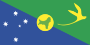
Flag description
- territorial flag; divided diagonally from upper hoist to lower fly; the upper triangle is green with a yellow image of the Golden Bosun Bird superimposed; the lower triangle is blue with the Southern Cross constellation, representing Australia, superimposed; a centered yellow disk displays a green map of the island
- note
- the flag of Australia is used for official purposes
Government type
NA
Independence
none (territory of Australia)
International organization participation
none
Judicial branch
- highest court(s)
- under the terms of the Territorial Law Reform Act 1992, Western Australia provides court services as needed for the island including the Supreme Court and subordinate courts (District Court, Magistrate Court, Family Court, Children's Court, and Coroners' Court)
Legal system
legal system is under the authority of the governor general of Australia and Australian law
Legislative branch
- description
- unicameral Christmas Island Shire Council (9 seats; members directly elected by simple majority vote to serve 4-year terms with a portion of the membership renewed every 2 years)
- election results
- percent of vote - NA; seats - independents 9
- elections
- held every two years with half the members standing for election; last held In 2011 (next to be held in 2013)
National anthem
- note
- as a territory of Australia, "Advance Australia Fair" remains official as the national anthem, while "God Save the Queen" serves as the royal anthem (see Australia)
National holiday
Australia Day, 26 January (1788)
National symbol(s)
golden bosun bird
Political parties and leaders
none
Political pressure groups and leaders
none
Suffrage
18 years of age
Economy
Agriculture - products
NA
Budget
- expenditures
- $NA
- revenues
- $NA
Economy - overview
The main economic activities on Christmas Island are the mining of low grade phosphate, limited tourism, the provision of government services and more recently the construction and operation of the Immigration Detention Center. The government sector includes administration, health, education, policing, customs, quarantine and defense.
Exchange rates
- Australian dollars (AUD) per US dollar -
- 1.1094 (2014)
- 1.0358 (2013)
- 0.97 (2012)
- 0.9695 (2011)
- 1.0902 (2010)
Exports
$NA
Exports - commodities
phosphate
Fiscal year
1 July - 30 June
GDP (purchasing power parity)
$NA
Imports
$NA
Imports - commodities
consumer goods
Industries
tourism, phosphate extraction (near depletion)
Labor force
NA
Communications
Broadcast media
1 community radio station; satellite broadcasts of several Australian radio and TV stations (2009)
Internet country code
.cx
Internet users
- percent of population
- 16.7% (2001)
- total
- 464
Radio broadcast stations
AM 1, FM 2, shortwave 0 (2006)
Telephone system
- domestic
- GSM mobile-cellular telephone service replaced older analog system in February 2005
- general assessment
- service provided by the Australian network
- international
- country code - 61-8; satellite earth station - 1 (Intelsat provides telephone and telex service) (2005)
Television broadcast stations
0 (TV broadcasts received via satellite from mainland Australia) (2006)
Transportation
Airports
1 (2013)
Airports - with paved runways
- 1,524 to 2,437 m
- 1 (2013)
- total
- 1
Ports and terminals
- major seaport(s)
- Flying Fish Cove
Railways
- standard gauge
- 18 km 1.435-m (not in operation) (2010)
- total
- 18 km
Roadways
- paved
- 30 km
- total
- 140 km
- unpaved
- 110 km (2011)
Military and Security
Military - note
defense is the responsibility of Australia
Transnational Issues
Disputes - international
none