2011 Edition
CIA World Factbook 2011 Archive (HTML)
Introduction
Background
The uninhabited islands were discovered and colonized by the Portuguese in the 15th century; Cape Verde subsequently became a trading center for African slaves and later an important coaling and resupply stop for whaling and transatlantic shipping. Following independence in 1975, and a tentative interest in unification with Guinea-Bissau, a one-party system was established and maintained until multi-party elections were held in 1990. Cape Verde continues to exhibit one of Africa's most stable democratic governments. Repeated droughts during the second half of the 20th century caused significant hardship and prompted heavy emigration. As a result, Cape Verde's expatriate population is greater than its domestic one. Most Cape Verdeans have both African and Portuguese antecedents.
Geography
Area
- 4,033 sq km 4,033 sq km 0 sq km
- total
- 4,033 sq km
- water
- 0 sq km
Area - comparative
slightly larger than Rhode Island
Climate
temperate; warm, dry summer; precipitation meager and erratic
Coastline
965 km
Elevation extremes
- Atlantic Ocean 0 m Mt. Fogo 2,829 m (a volcano on Fogo Island)
- highest point
- Mt. Fogo 2,829 m (a volcano on Fogo Island)
- lowest point
- Atlantic Ocean 0 m
Environment - current issues
soil erosion; deforestation due to demand for wood used as fuel; water shortages; desertification; environmental damage has threatened several species of birds and reptiles; illegal beach sand extraction; overfishing
Environment - international agreements
- Biodiversity, Climate Change, Climate Change-Kyoto Protocol, Desertification, Endangered Species, Environmental Modification, Hazardous Wastes, Law of the Sea, Marine Dumping, Ozone Layer Protection, Ship Pollution, Wetlands none of the selected agreements
- party to
- Biodiversity, Climate Change, Climate Change-Kyoto Protocol, Desertification, Endangered Species, Environmental Modification, Hazardous Wastes, Law of the Sea, Marine Dumping, Ozone Layer Protection, Ship Pollution, Wetlands
- signed, but not ratified
- none of the selected agreements
Freshwater withdrawal (domestic/industrial/agricultural)
- 0.02 cu km/yr (7%/2%/91%) 39 cu m/yr (2000)
- per capita
- 39 cu m/yr (2000)
- total
- 0.02 cu km/yr (7%/2%/91%)
Geographic coordinates
16 00 N, 24 00 W
Geography - note
strategic location 500 km from west coast of Africa near major north-south sea routes; important communications station; important sea and air refueling site
Irrigated land
30 sq km (2008)
Land boundaries
0 km
Land use
- 11.41% 0.74% 87.85% (2005)
- arable land
- 11.41%
- other
- 87.85% (2005)
- permanent crops
- 0.74%
Location
Western Africa, group of islands in the North Atlantic Ocean, west of Senegal
Map references
Africa
Maritime claims
- measured from claimed archipelagic baselines 12 nm 24 nm 200 nm
- contiguous zone
- 24 nm
- exclusive economic zone
- 200 nm
- territorial sea
- 12 nm
Natural hazards
- prolonged droughts; seasonal harmattan wind produces obscuring dust; volcanically and seismically active Fogo (elev. 2,829 m), which last erupted in 1995, is Cape Verde's only active volcano
- volcanism
- Fogo (elev. 2,829 m), which last erupted in 1995, is Cape Verde's only active volcano
Natural resources
salt, basalt rock, limestone, kaolin, fish, clay, gypsum
Terrain
steep, rugged, rocky, volcanic
Total renewable water resources
0.3 cu km (1990)
People and Society
Age structure
- 32.6% (male 84,545/female 83,718) 61.9% (male 154,697/female 164,917) 5.5% (male 10,648/female 17,575) (2011 est.)
- 0-14 years
- 32.6% (male 84,545/female 83,718)
- 15-64 years
- 61.9% (male 154,697/female 164,917)
- 65 years and over
- 5.5% (male 10,648/female 17,575) (2011 est.)
Birth rate
21.47 births/1,000 population (2011 est.)
Death rate
6.34 deaths/1,000 population (July 2011 est.)
Drinking water source
- urban: 85% of population rural: 82% of population total: 84% of population urban: 15% of population rural: 17% of population total: 16% of population (2008)
- rural
- 17% of population
- total
- 16% of population (2008)
- urban
- 15% of population
Education expenditures
5.9% of GDP (2009)
Ethnic groups
Creole (mulatto) 71%, African 28%, European 1%
Health expenditures
3.9% of GDP (2009)
HIV/AIDS - adult prevalence rate
0.04% (2001 est.)
HIV/AIDS - deaths
225 (as of 2001)
HIV/AIDS - people living with HIV/AIDS
775 (2001)
Hospital bed density
2.07 beds/1,000 population (2009)
Infant mortality rate
- 26.94 deaths/1,000 live births 30.8 deaths/1,000 live births 22.96 deaths/1,000 live births (2011 est.)
- female
- 22.96 deaths/1,000 live births (2011 est.)
- total
- 26.94 deaths/1,000 live births
Languages
Portuguese (official), Crioulo (a blend of Portuguese and West African words)
Life expectancy at birth
- 70.7 years 68.51 years 72.96 years (2011 est.)
- female
- 72.96 years (2011 est.)
- total population
- 70.7 years
Literacy
- age 15 and over can read and write 76.6% 85.8% 69.2% (2003 est.)
- definition
- age 15 and over can read and write
- female
- 69.2% (2003 est.)
- male
- 85.8%
- total population
- 76.6%
Major cities - population
PRAIA (capital) 125,000 (2009)
Maternal mortality rate
94 deaths/100,000 live births (2008)
Median age
- 22.7 years 21.9 years 23.5 years (2011 est.)
- female
- 23.5 years (2011 est.)
- male
- 21.9 years
- total
- 22.7 years
Nationality
- Cape Verdean(s) Cape Verdean
- adjective
- Cape Verdean
- noun
- Cape Verdean(s)
Net migration rate
-0.66 migrant(s)/1,000 population (2011 est.)
Physicians density
0.572 physicians/1,000 population (2008)
Population
516,100 (July 2011 est.)
Population growth rate
1.446% (2011 est.)
Religions
Roman Catholic (infused with indigenous beliefs), Protestant (mostly Church of the Nazarene)
Sanitation facility access
- urban: 65% of population rural: 38% of population total: 54% of population urban: 35% of population rural: 62% of population total: 46% of population (2008)
- rural
- 62% of population
- total
- 46% of population (2008)
- urban
- 35% of population
School life expectancy (primary to tertiary education)
- 12 years 11 years 12 years (2009)
- female
- 12 years (2009)
- male
- 11 years
- total
- 12 years
Sex ratio
- 1.03 male(s)/female 1.01 male(s)/female 0.94 male(s)/female 0.61 male(s)/female 0.94 male(s)/female (2011 est.)
- 15-64 years
- 0.94 male(s)/female
- 65 years and over
- 0.61 male(s)/female
- at birth
- 1.03 male(s)/female
- total population
- 0.94 male(s)/female (2011 est.)
- under 15 years
- 1.01 male(s)/female
Total fertility rate
2.49 children born/woman (2011 est.)
Urbanization
- 61% of total population (2010) 2.4% annual rate of change (2010-15 est.)
- rate of urbanization
- 2.4% annual rate of change (2010-15 est.)
- urban population
- 61% of total population (2010)
Government
Administrative divisions
17 municipalities (concelhos, singular - concelho); Boa Vista, Brava, Maio, Mosteiros, Paul, Praia, Porto Novo, Ribeira Grande, Sal, Santa Catarina, Santa Cruz, Sao Domingos, Sao Filipe, Sao Miguel, Sao Nicolau, Sao Vicente, Tarrafal
Capital
- Praia 14 55 N, 23 31 W UTC-1 (4 hours ahead of Washington, DC during Standard Time)
- geographic coordinates
- 14 55 N, 23 31 W
- name
- Praia
- time difference
- UTC-1 (4 hours ahead of Washington, DC during Standard Time)
Constitution
25 September 1992; a major revision on 23 November 1995 substantially increased the powers of the president; a 1999 revision created the position of national ombudsman (Provedor de Justica)
Country name
- Republic of Cape Verde Cape Verde Republica de Cabo Verde Cabo Verde
- conventional long form
- Republic of Cape Verde
- conventional short form
- Cape Verde
- local long form
- Republica de Cabo Verde
- local short form
- Cabo Verde
Diplomatic representation from the US
- Ambassador (vacant); Charge d'Affaires Dana BROWN Rua Abilio Macedo n6, Praia C. P. 201, Praia [238] 2-60-89-00 [238] 2-61-13-55
- chief of mission
- Ambassador (vacant); Charge d'Affaires Dana BROWN
- embassy
- Rua Abilio Macedo n6, Praia
- FAX
- [238] 2-61-13-55
- mailing address
- C. P. 201, Praia
- telephone
- [238] 2-60-89-00
Diplomatic representation in the US
- Ambassador Fatima Lima VEIGA 3415 Massachusetts Avenue NW, Washington, DC 20008 [1] (202) 965-6820 [1] (202) 965-1207 Boston
- chancery
- 3415 Massachusetts Avenue NW, Washington, DC 20008
- chief of mission
- Ambassador Fatima Lima VEIGA
- consulate(s) general
- Boston
- FAX
- [1] (202) 965-1207
- telephone
- [1] (202) 965-6820
Executive branch
- President Jorge Carlos FONSECA (since 9 September 2011) Prime Minister Jose Maria Pereira NEVES (since 1 February 2001) Council of Ministers appointed by the president on the recommendation of the prime minister president elected by popular vote for a five-year term (eligible for a second term); election last held on 7 August 2011 with a second round runoff on 21 August 2011; prime minister nominated by the National Assembly and appointed by the president percent of vote (second round) - Jorge Carlos FONSECA 53.4%, Manuel Inocencio SOUSA 46.6%
- cabinet
- Council of Ministers appointed by the president on the recommendation of the prime minister
- chief of state
- President Jorge Carlos FONSECA (since 9 September 2011)
- election results
- percent of vote (second round) - Jorge Carlos FONSECA 53.4%, Manuel Inocencio SOUSA 46.6%
- elections
- president elected by popular vote for a five-year term (eligible for a second term); election last held on 7 August 2011 with a second round runoff on 21 August 2011; prime minister nominated by the National Assembly and appointed by the president
- head of government
- Prime Minister Jose Maria Pereira NEVES (since 1 February 2001)
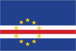
Flag description
five unequal horizontal bands; the top-most band of blue - equal to one half the width of the flag - is followed by three bands of white, red, and white, each equal to 1/12 of the width, and a bottom stripe of blue equal to one quarter of the flag width; a circle of 10, yellow, five-pointed stars is centered on the red stripe and positioned 3/8 of the length of the flag from the hoist side; blue stands for the sea and the sky, the circle of stars represents the 10 major islands united into a nation, the stripes symbolize the road to formation of the country through peace (white) and effort (red)
Government type
republic
Independence
5 July 1975 (from Portugal)
International law organization participation
has not submitted an ICJ jurisdiction declaration; non-party state to the ICCt
International organization participation
ACP, AfDB, AOSIS, AU, CD, CPLP, ECOWAS, FAO, G-77, IAEA, IBRD, ICAO, ICRM, IDA, IFAD, IFC, IFRCS, ILO, IMF, IMO, Interpol, IOC, IOM, IPU, ITSO, ITU, ITUC, MIGA, NAM, OIF, OPCW, UN, UNCTAD, UNESCO, UNIDO, Union Latina, UNWTO, UPU, WCO, WHO, WIPO, WMO, WTO
Judicial branch
Supreme Tribunal of Justice or Supremo Tribunal de Justia; Court of Audit; Military Courts; Fiscal and Customs Courts
Legal system
civil law system of Portugal
Legislative branch
- unicameral National Assembly or Assembleia Nacional (72 seats; members elected by popular vote to serve five-year terms) last held on 6 February 2011 (next to be held by 2016) percent of vote by party - NA; seats by party - PAICV 38, MPD 32, UCID 2
- election results
- percent of vote by party - NA; seats by party - PAICV 38, MPD 32, UCID 2
- elections
- last held on 6 February 2011 (next to be held by 2016)
National anthem
- "Cantico da Liberdade" (Song of Freedom) Amilcar Spencer LOPES/Adalberto Higino Tavares SILVA adopted 1996
- lyrics/music
- Amilcar Spencer LOPES/Adalberto Higino Tavares SILVA
- name
- "Cantico da Liberdade" (Song of Freedom)
National holiday
Independence Day, 5 July (1975)
Political parties and leaders
African Party for Independence of Cape Verde or PAICV [Jose Maria Pereira NEVES, chairman]; Democratic and Independent Cape Verdean Union or UCID [Antonio MONTEIRO]; Democratic Christian Party or PDC [Manuel RODRIGUES]; Democratic Renovation Party or PRD [Victor FIDALGO]; Movement for Democracy or MPD [Jorge SANTOS]; Party for Democratic Convergence or PCD [Dr. Eurico MONTEIRO]; Party of Work and Solidarity or PTS [Isaias RODRIGUES]; Social Democratic Party or PSD [Joao ALEM]
Political pressure groups and leaders
- environmentalists; political pressure groups
- other
- environmentalists; political pressure groups
Suffrage
18 years of age; universal
Economy
Agriculture - products
bananas, corn, beans, sweet potatoes, sugarcane, coffee, peanuts; fish
Budget
- $559.7 million $785.5 million (2010 est.)
- expenditures
- $785.5 million (2010 est.)
- revenues
- $559.7 million
Budget surplus (+) or deficit (-)
-13.7% of GDP (2010 est.)
Central bank discount rate
7.5% (31 December 2010 est.) 7.5% (31 December 2009 est.)
Commercial bank prime lending rate
11% (31 December 2010 est.) 11% (31 December 2009 est.)
Current account balance
-$219.4 million (2010 est.) -$154 million (2009 est.)
Debt - external
$325 million (2002)
Economy - overview
This island economy suffers from a poor natural resource base, including serious water shortages exacerbated by cycles of long-term drought and poor soil for agriculture on several of the islands. The economy is service oriented with commerce, transport, tourism, and public services accounting for about three-fourths of GDP. Although about 40% of the population lives in rural areas, the share of food production in GDP is low. About 82% of food must be imported. The fishing potential, mostly lobster and tuna, is not fully exploited. Cape Verde annually runs a high trade deficit financed by foreign aid and remittances from its large pool of emigrants; remittances supplement GDP by more than 20%. Despite the lack of resources, sound economic management has produced steadily improving incomes. Continued economic reforms are aimed at developing the private sector and attracting foreign investment to diversify the economy. Future prospects depend heavily on the maintenance of aid flows, the encouragement of tourism, remittances, and the momentum of the government's development program. Cape Verde became a member of the WTO in July 2008.
Electricity - consumption
238.6 million kWh (2008 est.)
Electricity - exports
0 kWh (2009 est.)
Electricity - imports
0 kWh (2009 est.)
Electricity - production
256.5 million kWh (2008 est.)
Exchange rates
Cape Verdean escudos (CVE) per US dollar - 88.58 (2010) 79.38 (2009) 73.84 (2008) 81.235 (2007) 87.946 (2006)
Exports
$97.8 million (2010 est.) $91 million (2009 est.)
Exports - commodities
fuel, shoes, garments, fish, hides
Exports - partners
Spain 61.9%, Portugal 16.6%, Morocco 6.9% (2010)
GDP - composition by sector
- 8.9% 16.1% 75.1% (2010 est.)
- agriculture
- 8.9%
- industry
- 16.1%
- services
- 75.1% (2010 est.)
GDP - per capita (PPP)
$3,800 (2010 est.) $3,600 (2009 est.) $3,500 (2008 est.) data are in 2010 US dollars
GDP - real growth rate
5.4% (2010 est.) 3.6% (2009 est.) 6.2% (2008 est.)
GDP (official exchange rate)
$1.651 billion (2010 est.)
GDP (purchasing power parity)
$1.908 billion (2010 est.) $1.81 billion (2009 est.) $1.747 billion (2008 est.) data are in 2010 US dollars
Household income or consumption by percentage share
- 1.9% 40.6% (2000)
- highest 10%
- 40.6% (2000)
- lowest 10%
- 1.9%
Imports
$796.7 million (2010 est.) $720.6 million (2009 est.)
Imports - commodities
foodstuffs, industrial products, transport equipment, fuels
Imports - partners
Portugal 41.6%, Netherlands 17.7%, Spain 6.9%, China 4.1% (2010)
Industrial production growth rate
4% (2010 est.)
Industries
food and beverages, fish processing, shoes and garments, salt mining, ship repair
Inflation rate (consumer prices)
2.1% (2010 est.) 1% (2009 est.)
Investment (gross fixed)
36.1% of GDP (2010 est.)
Labor force
196,100 (2007)
Natural gas - consumption
0 cu m (2009 est.)
Natural gas - exports
0 cu m (2009 est.)
Natural gas - imports
0 cu m (2009 est.)
Natural gas - production
0 cu m (2009 est.)
Natural gas - proved reserves
0 cu m (1 January 2011 est.)
Oil - consumption
2,000 bbl/day (2010 est.)
Oil - exports
0 bbl/day (2009 est.)
Oil - imports
2,336 bbl/day (2009 est.)
Oil - production
0 bbl/day (2010 est.)
Oil - proved reserves
0 bbl (1 January 2011 est.)
Population below poverty line
30% (2000)
Reserves of foreign exchange and gold
$394.2 million (31 December 2010 est.) $366 million (31 December 2009 est.)
Stock of broad money
$1.441 billion (31 December 2010 est.) $1.467 billion (31 December 2009 est.)
Stock of domestic credit
$1.295 billion (31 December 2010 est.) $1.317 billion (31 December 2009 est.)
Stock of narrow money
$640.1 million (31 December 2010 est.) $659.2 million (31 December 2009 est.)
Taxes and other revenues
33.9% of GDP (2010 est.)
Unemployment rate
21% (2000 est.)
Communications
Broadcast media
state-run TV and radio broadcast network plus a growing number of private broadcasters; Portuguese public TV and radio services for Africa are available; transmissions of a few international broadcasters are obtainable (2007)
Internet country code
.cv
Internet hosts
26 (2010)
Internet users
150,000 (2009)
Telephone system
- effective system, extensive modernization from 1996-2000 following partial privatization in 1995 major service provider is Cabo Verde Telecom (CVT); fiber-optic ring, completed in 2001, links all islands providing Internet access and ISDN services; cellular service introduced in 1998; broadband services launched in 2004 country code - 238; landing point for the Atlantis-2 fiber-optic transatlantic telephone cable that provides links to South America, Senegal, and Europe; HF radiotelephone to Senegal and Guinea-Bissau; satellite earth station - 1 Intelsat (Atlantic Ocean) (2007)
- domestic
- major service provider is Cabo Verde Telecom (CVT); fiber-optic ring, completed in 2001, links all islands providing Internet access and ISDN services; cellular service introduced in 1998; broadband services launched in 2004
- general assessment
- effective system, extensive modernization from 1996-2000 following partial privatization in 1995
- international
- country code - 238; landing point for the Atlantis-2 fiber-optic transatlantic telephone cable that provides links to South America, Senegal, and Europe; HF radiotelephone to Senegal and Guinea-Bissau; satellite earth station - 1 Intelsat (Atlantic Ocean) (2007)
Telephones - main lines in use
72,000 (2010)
Telephones - mobile cellular
371,900 (2010)
Transportation
Airports
10 (2010)
Airports - with paved runways
- 2 (2010)
- 1,524 to 2,437 m
- 3
- 914 to 1,523 m
- 3
- over 3,047 m
- 1
- total
- 9
- under 914 m
- 2 (2010)
Airports - with unpaved runways
- 1 (2010)
- total
- 1
- under 914 m
- 1 (2010)
Merchant marine
- cargo 3, chemical tanker 3, passenger/cargo 7 3 (Spain 1, UK 2) (2010)
- foreign-owned
- 3 (Spain 1, UK 2) (2010)
- total
- 13
Ports and terminals
Porto Grande
Roadways
- 1,350 km 932 km 418 km (2000)
- total
- 1,350 km
- unpaved
- 418 km (2000)
Military and Security
Manpower available for military service
- 132,087 136,956 (2010 est.)
- females age 16-49
- 136,956 (2010 est.)
- males age 16-49
- 132,087
Manpower fit for military service
- 106,864 117,518 (2010 est.)
- females age 16-49
- 117,518 (2010 est.)
- males age 16-49
- 106,864
Manpower reaching militarily significant age annually
- 6,029 6,026 (2010 est.)
- female
- 6,026 (2010 est.)
- male
- 6,029
Military branches
- Armed Forces: Army (also called the National Guard), Cape Verde Coast Guard (Guardia Costeira de Cabo Verde, GCCV; includes naval infantry) (2011)
- Armed Forces
- Army (also called the National Guard), Cape Verde Coast Guard (Guardia Costeira de Cabo Verde, GCCV; includes naval infantry) (2011)
Military expenditures
0.5% of GDP (2009)
Military service age and obligation
18 years of age (est.) for selective compulsory military service; 14-month conscript service obligation (2006)
Transnational Issues
Disputes - international
none
Illicit drugs
used as a transshipment point for Latin American cocaine destined for Western Europe, particularly because of Lusophone links to Brazil, Portugal, and Guinea-Bissau; has taken steps to deter drug money laundering, including a 2002 anti-money laundering reform that criminalizes laundering the proceeds of narcotics trafficking and other crimes and the establishment in 2008 of a Financial Intelligence Unit (2008)