2015 Edition
CIA World Factbook 2015 Archive (Wayback Machine ZIP)
Introduction
Background
French Cameroon became independent in 1960 as the Republic of Cameroon. The following year the southern portion of neighboring British Cameroon voted to merge with the new country to form the Federal Republic of Cameroon. In 1972, a new constitution replaced the federation with a unitary state, the United Republic of Cameroon. The country has generally enjoyed stability, which has enabled the development of agriculture, roads, and railways, as well as a petroleum industry. Despite slow movement toward democratic reform, political power remains firmly in the hands of President Paul BIYA.
Geography
Area
- land
- 472,710 sq km
- total
- 475,440 sq km
- water
- 2,730 sq km
Area - comparative
slightly larger than California
Climate
varies with terrain, from tropical along coast to semiarid and hot in north
Coastline
402 km
Elevation extremes
- highest point
- Fako 4,095 m (on Cameroon Mountain)
- lowest point
- Atlantic Ocean 0 m
Environment - current issues
waterborne diseases are prevalent; deforestation; overgrazing; desertification; poaching; overfishing
Environment - international agreements
- party to
- Biodiversity, Climate Change, Climate Change-Kyoto Protocol, Desertification, Endangered Species, Hazardous Wastes, Law of the Sea, Ozone Layer Protection, Tropical Timber 83, Tropical Timber 94, Wetlands, Whaling
- signed, but not ratified
- none of the selected agreements
Freshwater withdrawal (domestic/industrial/agricultural)
- per capita
- 58.9 cu m/yr (2005)
- total
- 0.97 cu km/yr (23%/10%/68%)
Geographic coordinates
6 00 N, 12 00 E
Geography - note
sometimes referred to as the hinge of Africa; throughout the country there are areas of thermal springs and indications of current or prior volcanic activity; Mount Cameroon, the highest mountain in Sub-Saharan west Africa, is an active volcano
Irrigated land
256.5 sq km (2003)
Land boundaries
- border countries (6)
- Central African Republic 901 km, Chad 1,116 km, Republic of the Congo 494 km, Equatorial Guinea 183 km, Gabon 349 km, Nigeria 1,975 km
- total
- 5,018 km
Land use
- arable land 13.1%; permanent crops 3.3%; permanent pasture 4.2%
- agricultural land
- 20.6%
- forest
- 41.7%
- other
- 37.7% (2011 est.)
Location
Central Africa, bordering the Bight of Biafra, between Equatorial Guinea and Nigeria
Map references
Africa
Maritime claims
- contiguous zone
- 24 nm
- territorial sea
- 12 nm
Natural hazards
- volcanic activity with periodic releases of poisonous gases from Lake Nyos and Lake Monoun volcanoes
- volcanism
- Mt. Cameroon (elev. 4,095 m), which last erupted in 2000, is the most frequently active volcano in West Africa; lakes in Oku volcanic field have released fatal levels of gas on occasion, killing some 1,700 people in 1986
Natural resources
petroleum, bauxite, iron ore, timber, hydropower
Terrain
diverse, with coastal plain in southwest, dissected plateau in center, mountains in west, plains in north
Total renewable water resources
285.5 cu km (2011)
People and Society
Age structure
- 0-14 years
- 42.78% (male 5,115,958/female 5,039,122)
- 15-24 years
- 19.58% (male 2,337,061/female 2,310,178)
- 25-54 years
- 30.53% (male 3,644,779/female 3,603,610)
- 55-64 years
- 3.96% (male 458,001/female 481,717)
- 65 years and over
- 3.15% (male 348,754/female 400,038) (2015 est.)
Birth rate
36.17 births/1,000 population (2015 est.)
Child labor - children ages 5-14
- percentage
- 31% (2006 est.)
- total number
- 1,396,281
Children under the age of 5 years underweight
15.1% (2011)
Contraceptive prevalence rate
23.4% (2011)
Death rate
10.11 deaths/1,000 population (2015 est.)
Dependency ratios
- elderly dependency ratio
- 5.9%
- potential support ratio
- 16.9% (2015 est.)
- total dependency ratio
- 84.3%
- youth dependency ratio
- 78.4%
Drinking water source
- urban: 94.8% of population
- rural: 52.7% of population
- total: 75.6% of population
- urban: 5.2% of population
- rural: 47.3% of population
- total: 24.4% of population (2015 est.)
Education expenditures
3% of GDP (2012)
Ethnic groups
Cameroon Highlanders 31%, Equatorial Bantu 19%, Kirdi 11%, Fulani 10%, Northwestern Bantu 8%, Eastern Nigritic 7%, other African 13%, non-African less than 1%
Health expenditures
5.1% of GDP (2013)
HIV/AIDS - adult prevalence rate
4.77% (2014 est.)
HIV/AIDS - deaths
34,200 (2014 est.)
HIV/AIDS - people living with HIV/AIDS
657,500 (2014 est.)
Hospital bed density
1.3 beds/1,000 population (2010)
Infant mortality rate
- female
- 49.88 deaths/1,000 live births (2015 est.)
- male
- 57.28 deaths/1,000 live births
- total
- 53.63 deaths/1,000 live births
Languages
24 major African language groups, English (official), French (official)
Life expectancy at birth
- female
- 59.28 years (2015 est.)
- male
- 56.62 years
- total population
- 57.93 years
Literacy
- definition
- age 15 and over can read and write
- female
- 68.9% (2015 est.)
- male
- 81.2%
- total population
- 75%
Major infectious diseases
- animal contact disease
- rabies (2013)
- degree of risk
- very high
- food or waterborne diseases
- bacterial and protozoal diarrhea, hepatitis A, and typhoid fever
- respiratory disease
- meningococcal meningitis
- vectorborne diseases
- malaria, dengue fever, and yellow fever
- water contact disease
- schistosomiasis
Major urban areas - population
YAOUNDE (capital) 3.066 million; Douala 2.943 million (2015)
Median age
- female
- 18.5 years (2015 est.)
- male
- 18.3 years
- total
- 18.4 years
Nationality
- adjective
- Cameroonian
- noun
- Cameroonian(s)
Net migration rate
-0.15 migrant(s)/1,000 population (2015 est.)
Obesity - adult prevalence rate
9.6% (2014)
Physicians density
0.08 physicians/1,000 population (2009)
Population
- 23,739,218
- note
- estimates for this country explicitly take into account the effects of excess mortality due to AIDS; this can result in lower life expectancy, higher infant mortality, higher death rates, lower population growth rates, and changes in the distribution of population by age and sex than would otherwise be expected (July 2015 est.)
Population growth rate
2.59% (2015 est.)
Religions
indigenous beliefs 40%, Christian 40%, Muslim 20%
Sanitation facility access
- urban: 61.8% of population
- rural: 26.8% of population
- total: 45.8% of population
- urban: 38.2% of population
- rural: 73.2% of population
- total: 54.2% of population (2015 est.)
School life expectancy (primary to tertiary education)
- female
- 10 years (2011)
- male
- 11 years
- total
- 10 years
Sex ratio
- 0-14 years
- 1.02 male(s)/female
- 15-24 years
- 1.01 male(s)/female
- 25-54 years
- 1.01 male(s)/female
- 55-64 years
- 0.95 male(s)/female
- 65 years and over
- 0.87 male(s)/female
- at birth
- 1.03 male(s)/female
- total population
- 1.01 male(s)/female (2015 est.)
Total fertility rate
4.76 children born/woman (2015 est.)
Urbanization
- rate of urbanization
- 3.6% annual rate of change (2010-15 est.)
- urban population
- 54.4% of total population (2015)
Government
Administrative divisions
10 regions (regions, singular - region); Adamaoua, Centre, East (Est), Far North (Extreme-Nord), Littoral, North (Nord), North-West (Nord-Ouest), West (Ouest), South (Sud), South-West (Sud-Ouest)
Capital
- geographic coordinates
- 3 52 N, 11 31 E
- name
- Yaounde
- time difference
- UTC+1 (6 hours ahead of Washington, DC, during Standard Time)
Constitution
several previous; latest effective 18 January 1996; amended 2008 (2008)
Country name
- conventional long form
- Republic of Cameroon
- conventional short form
- Cameroon
- former
- French Cameroon, British Cameroon, Federal Republic of Cameroon, United Republic of Cameroon
- local long form
- Republique du Cameroun/Republic of Cameroon
- local short form
- Cameroun/Cameroon
Diplomatic representation from the US
- branch office(s)
- Douala
- chief of mission
- Ambassador Michael Stephen HOZA (since 19 September 2014)
- embassy
- Avenue Rosa Parks, Yaounde
- FAX
- [237] 22220 15 00 Ext. 4531; Consular FAX: [237] 22220 17 52
- mailing address
- P. O. Box 817, Yaounde; pouch: American Embassy, US Department of State, Washington, DC 20521-2520
- telephone
- [237] 22220 15 00; Consular: [237] 22220 16 03
Diplomatic representation in the US
- chancery
- 2349 Massachusetts Avenue NW, Washington, DC 20008; current temporary address - 3400 International Drive NW, Washington, DC 20008
- chief of mission
- Ambassador Joseph FOE-ATANGANA (since 12 September 2008)
- FAX
- [1] (202) 387-3826
- telephone
- [1] (202) 265-8790
Executive branch
- cabinet
- Cabinet proposed by the prime minister, appointed by the president
- chief of state
- President Paul BIYA (since 6 November 1982)
- election results
- Paul BIYA reelected president; percent of vote - Paul BIYA (CPDM) 78.0%, John FRU NDI (SDF) 10.7%, Garga Haman ADJI 3.2%, other 8.1%
- elections/appointments
- president directly elected by simple majority popular vote for a 7-year term (no term limits); election last held on 9 October 2011 (next to be held in October 2018); prime minister appointed by the president
- head of government
- Prime Minister Philemon YANG (since 30 June 2009)
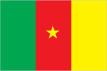
Flag description
- three equal vertical bands of green (hoist side), red, and yellow, with a yellow five-pointed star centered in the red band; the vertical tricolor recalls the flag of France; red symbolizes unity, yellow the sun, happiness, and the savannahs in the north, and green hope and the forests in the south; the star is referred to as the "star of unity"
- note
- uses the popular Pan-African colors of Ethiopia
Government type
republic; multiparty presidential regime
Independence
1 January 1960 (from French-administered UN trusteeship)
International law organization participation
accepts compulsory ICJ jurisdiction; non-party state to the ICCt
International organization participation
ACP, AfDB, AU, BDEAC, C, CEMAC, EITI (compliant country), FAO, FZ, G-77, IAEA, IBRD, ICAO, ICRM, IDA, IDB, IFAD, IFC, IFRCS, IHO, ILO, IMF, IMO, IMSO, Interpol, IOC, IOM, IPU, ISO, ITSO, ITU, ITUC (NGOs), MIGA, MONUSCO, NAM, OIC, OIF, OPCW, PCA, UN, UNCTAD, UNESCO, UNHCR, UNIDO, UNOCI, UNWTO, UPU, WCO, WFTU (NGOs), WHO, WIPO, WMO, WTO
Judicial branch
- highest court(s)
- Supreme Court of Cameroon (consists of 9 titular and 6 surrogate judges and organized into judicial, administrative, and audit chambers); Constitutional Council (consists of 11 members)
- judge selection and term of office
- Supreme Court judges appointed by the president with the advice of the Higher Judicial Council of Cameroon, a body chaired by the president and includes the minister of justice, selected magistrates, and representatives of the National Assembly; judge term NA; Constitutional Council members appointed by the president for single 9-year terms
- subordinate courts
- Parliamentary Court of Justice (jurisdiction limited to cases involving the president and prime minister); appellate and first instance courts; circuit and magistrate's courts
Legal system
mixed legal system of English common law, French civil law, and customary law
Legislative branch
- description
- bicameral Parliament or Parlement consists of the Senate or Senat (100 seats; 70 members indirectly elected by regional councils and 30 appointed by the president; members serve 5-year terms) and the National Assembly or Assemblee Nationale (180 seats; members directly elected in multi-seat constituencies by simple majority vote to serve 5-year terms); note - the 100-member Senate was formed at the time of the April 2013 election
- election results
- Senate percent of vote by party - NA; seats by party - CPDM 56, SDF 14; National Assembly percent of vote by party - NA; seats by party - CPDM 148, SDF 18, UNDP 5, UDC 4, UPC 3, other 2
- elections
- Senate last held on 14 April 2013 (next to be held in 2018); National Assembly last held on 30 September 2013 (next to be held in 2018)
National anthem
- lyrics/music
- Rene Djam AFAME, Samuel Minkio BAMBA, Moise Nyatte NKO'O [French], Benard Nsokika FONLON [English]/Rene Djam AFAME
- name
- "O Cameroun, Berceau de nos Ancetres" (O Cameroon, Cradle of Our Forefathers)
- note
- adopted 1957; Cameroon's anthem, also known as "Chant de Ralliement" (The Rallying Song), has been used unofficially since 1948 and officially adopted in 1957; the anthem has French and English versions whose lyrics differ
National holiday
State Unification Day (National Day), 20 May (1972)
National symbol(s)
lion; national colors: green, red, yellow
Political parties and leaders
- Cameroon People's Democratic Movement or CPDM [Paul BIYA]
- Cameroon People's Party or CPP [Edith Kah WALLA]
- Cameroonian Democratic Union or UDC [Adamou Ndam NJOYA]
- Movement for the Defense of the Republic or MDR [Dakole DAISSALA]
- Movement for the Liberation and Development of Cameroon or MLDC [Marcel YONDO]
- National Union for Democracy and Progress or UNDP [Maigari BELLO BOUBA]
- Progressive Movement or MP [Jean-Jacques EKINDI]
- Social Democratic Front or SDF [John FRU NDI]
- Union of Peoples of Cameroon or UPC [Provisionary Management Bureau]
Political pressure groups and leaders
- Network of Human Rights Defenders in Central Africa or REDHAC [Maximilliene Ngo MBE]
- Tribunal 53 [Patrice NGANANG]
Suffrage
20 years of age; universal
Economy
Agriculture - products
coffee, cocoa, cotton, rubber, bananas, oilseed, grains, cassava (manioc, tapioca); livestock; timber
Budget
- expenditures
- $6.92 billion (2014 est.)
- revenues
- $5.503 billion
Budget surplus (+) or deficit (-)
-4.4% of GDP (2014 est.)
Central bank discount rate
4.25% (31 December 2009)
Commercial bank prime lending rate
- 13.8% (31 December 2014 est.)
- 14% (31 December 2013 est.)
Current account balance
- -$1.333 billion (2014 est.)
- -$1.332 billion (2013 est.)
Debt - external
- $5.006 billion (31 December 2014 est.)
- $4.217 billion (31 December 2013 est.)
Distribution of family income - Gini index
- 44.6 (2001)
- 47.7 (1996)
Economy - overview
Modest oil resources and favorable agricultural conditions provide Cameroon with one of the best-endowed primary commodity economies in sub-Saharan Africa. Cameroon’s economy suffers from political and economic factors that often impact underdeveloped countries, such as stagnant per capita income, a relatively inequitable distribution of income, a top-heavy civil service, endemic corruption, the continuing inefficiencies of a large parastatal system in key sectors, and a generally unfavorable climate for business enterprise. Since 1990, the government has embarked on various IMF and World Bank programs designed to spur business investment, increase efficiency in agriculture, improve trade, and recapitalize the nation's banks. The IMF continues to press for economic reforms, including increased budget transparency, privatization, and poverty reduction programs. The Government of Cameroon provides subsidies for electricity, food, and fuel that have strained the federal budget diverting funds from education, healthcare, and infrastructure projects. Cameroon devotes significant resources to several large infrastructure projects under construction, including a deep sea port in Kribi and the Lom Pangar Hydropower Project. Cameroon’s energy sector continues to diversify, recently opening a natural gas powered electricity generating plant. Oil remains Cameroon’s main export commodity accounting for nearly 40% of export earnings despite falling global oil prices. Cameroon continues to seek foreign investment to improve its inadequate infrastructure, create jobs and improve its economic footprint but its unfavorable business environment remains a significant deterrent to foreign investment.
Exchange rates
- Cooperation Financiere en Afrique Centrale francs (XAF) per dollar -
- 491.2 (2014 est.)
- 494.04 (2013 est.)
- 510.53 (2012 est.)
- 471.87 (2011 est.)
- 495.28 (2010 est.)
Exports
- $6.376 billion (2014 est.)
- $5.819 billion (2013 est.)
Exports - commodities
crude oil and petroleum products, lumber, cocoa beans, aluminum, coffee, cotton
Exports - partners
Spain 13.9%, China 12%, India 10.1%, Italy 8.1%, Netherlands 8%, Belgium 5.1%, France 4.6%, Norway 4.5%, UK 4.3% (2014)
Fiscal year
1 July - 30 June
GDP - composition, by end use
- (2014 est.)
- exports of goods and services
- 28.6%
- government consumption
- 14%
- household consumption
- 68.9%
- imports of goods and services
- -32.5%
- investment in fixed capital
- 21%
- investment in inventories
- 0%
GDP - composition, by sector of origin
- agriculture
- 19.9%
- industry
- 27.6%
- services
- 52.5% (2014 est.)
GDP - per capita (PPP)
- $3,000 (2014 est.)
- $2,800 (2013 est.)
- $2,700 (2012 est.)
- note
- data are in 2014 US dollars
GDP - real growth rate
- 5.1% (2014 est.)
- 5.6% (2013 est.)
- 4.6% (2012 est.)
GDP (official exchange rate)
$31.67 billion (2014 est.)
GDP (purchasing power parity)
- $67.2 billion (2014 est.)
- $63.92 billion (2013 est.)
- $60.54 billion (2012 est.)
- note
- data are in 2014 US dollars
Gross national saving
- 17.9% of GDP (2014 est.)
- 17.8% of GDP (2013 est.)
- 17.1% of GDP (2012 est.)
Household income or consumption by percentage share
- highest 10%
- 35.4% (2001)
- lowest 10%
- 2.3%
Imports
- $6.937 billion (2014 est.)
- $6.484 billion (2013 est.)
Imports - commodities
machinery, electrical equipment, transport equipment, fuel, food
Imports - partners
China 26.2%, Nigeria 12%, France 11.8%, Belgium 4.9%, US 4.2% (2014)
Industrial production growth rate
4.9% (2014 est.)
Industries
petroleum production and refining, aluminum production, food processing, light consumer goods, textiles, lumber, ship repair
Inflation rate (consumer prices)
- 1.9% (2014 est.)
- 1.9% (2013 est.)
Labor force
9.105 million (2014 est.)
Labor force - by occupation
- agriculture
- 70%
- industry
- 13%
- services
- 17% (2001 est.)
Market value of publicly traded shares
$230 million (31 December 2012 est.)
Population below poverty line
48% (2000 est.)
Public debt
- 22.7% of GDP (2014 est.)
- 19.4% of GDP (2013 est.)
Reserves of foreign exchange and gold
- $3.503 billion (31 December 2014 est.)
- $3.384 billion (31 December 2013 est.)
Stock of broad money
- $6.439 billion (31 December 2014 est.)
- $6.633 billion (31 December 2013 est.)
Stock of domestic credit
- $3.318 billion (31 December 2014 est.)
- $3.114 billion (31 December 2013 est.)
Stock of narrow money
- $3.861 billion (31 December 2014 est.)
- $3.988 billion (31 December 2013 est.)
Taxes and other revenues
17.1% of GDP (2014 est.)
Unemployment rate
30% (2001 est.)
Energy
Carbon dioxide emissions from consumption of energy
6.224 million Mt (2012 est.)
Crude oil - exports
55,680 bbl/day (2010 est.)
Crude oil - imports
34,220 bbl/day (2010 est.)
Crude oil - production
62,760 bbl/day (2013 est.)
Crude oil - proved reserves
200 million bbl (1 January 2014 est.)
Electricity - consumption
5.267 billion kWh (2011 est.)
Electricity - exports
0 kWh (2013 est.)
Electricity - from fossil fuels
28.6% of total installed capacity (2011 est.)
Electricity - from hydroelectric plants
71.4% of total installed capacity (2011 est.)
Electricity - from nuclear fuels
0% of total installed capacity (2011 est.)
Electricity - from other renewable sources
0% of total installed capacity (2011 est.)
Electricity - imports
0 kWh (2013 est.)
Electricity - installed generating capacity
1.007 million kW (2011 est.)
Electricity - production
5.857 billion kWh (2011 est.)
Natural gas - consumption
165 million cu m (2012 est.)
Natural gas - exports
0 cu m (2012 est.)
Natural gas - imports
0 cu m (2012 est.)
Natural gas - production
165 million cu m (2012 est.)
Natural gas - proved reserves
135.1 billion cu m (1 January 2014 est.)
Refined petroleum products - consumption
29,680 bbl/day (2013 est.)
Refined petroleum products - exports
13,370 bbl/day (2010 est.)
Refined petroleum products - imports
6,018 bbl/day (2010 est.)
Refined petroleum products - production
43,500 bbl/day (2010 est.)
Communications
Broadcast media
government maintains tight control over broadcast media; state-owned Cameroon Radio Television (CRTV), broadcasting on both a TV and radio network, was the only officially recognized and fully licensed broadcaster until August 2007, when the government finally issued licenses to 2 private TV broadcasters and 1 private radio broadcaster; about 70 privately owned, unlicensed radio stations operating but are subject to closure at any time; foreign news services required to partner with state-owned national station (2007)
Internet country code
.cm
Internet users
- percent of population
- 6.5% (2014 est.)
- total
- 1.5 million
Radio broadcast stations
AM 2, FM 9, shortwave 3 (2001)
Telephone system
- domestic
- mobile-cellular usage, in part a reflection of the poor condition and general inadequacy of the fixed-line network, has increased sharply, reaching a subscribership base of 50 per 100 persons
- general assessment
- system includes cable, microwave radio relay, and tropospheric scatter; Camtel, the monopoly provider of fixed-line service, provides connections for only about 3 per 100 persons; equipment is old and outdated, and connections with many parts of the country are unreliable
- international
- country code - 237; landing point for the SAT-3/WASC fiber-optic submarine cable that provides connectivity to Europe and Asia; satellite earth stations - 2 Intelsat (Atlantic Ocean) (2011)
Telephones - fixed lines
- subscriptions per 100 inhabitants
- 5 (2014 est.)
- total subscriptions
- 1.05 million
Telephones - mobile cellular
- subscriptions per 100 inhabitants
- 75 (2014 est.)
- total
- 17.3 million
Television broadcast stations
1 (2001)
Transportation
Airports
33 (2013)
Airports - with paved runways
- 1,524 to 2,437 m
- 3
- 2,438 to 3,047 m
- 5
- 914 to 1,523 m
- 1 (2013)
- over 3,047 m
- 2
- total
- 11
Airports - with unpaved runways
- 8 (2013)
- 1,524 to 2,437 m
- 4
- 914 to 1,523 m
- 10
- total
- 22
Pipelines
gas 53 km; liquid petroleum gas 5 km; oil 1,107 km; water 35 km (2013)
Ports and terminals
- oil terminal(s)
- Limboh Terminal
- river port(s)
- Douala (Wouri); Garoua (Benoue)
Railways
- narrow gauge
- 987 km 1.000-m gauge
- note
- railway connections generally efficient but limited; rail lines connect major cities of Douala, Yaounde, Ngaoundere, and Garoua; passenger and freight service provided by CAMRAIL (2014)
- total
- 987 km
Roadways
- note
- there are 28,857 km of national roads (2011)
- paved
- 4,108 km
- total
- 51,350 km
- unpaved
- 47,242 km
Waterways
(major rivers in the south, such as the Wouri and the Sanaga, are largely non-navigable; in the north, the Benue, which connects through Nigeria to the Niger River, is navigable in the rainy season only to the port of Garoua) (2010)
Military and Security
Manpower available for military service
- females age 16-49
- 4,548,909 (2010 est.)
- males age 16-49
- 4,667,251
Manpower fit for military service
- females age 16-49
- 2,718,110 (2010 est.)
- males age 16-49
- 2,794,998
Manpower reaching militarily significant age annually
- female
- 211,636 (2010 est.)
- male
- 215,248
Military branches
Cameroon Armed Forces (Forces Armees Camerounaises, FAC), Army (L'Armee de Terre), Navy (Marine Nationale Republique (MNR), includes naval infantry), Air Force (Armee de l'Air du Cameroun, AAC), Fire Fighter Corps, Gendarmerie (2013)
Military expenditures
- 1.42% of GDP (2012)
- 1.37% of GDP (2011)
- 1.42% of GDP (2010)
Military service age and obligation
18-23 years of age for male and female voluntary military service; no conscription; high school graduation required; service obligation 4 years; periodic government calls for volunteers (2012)
Transnational Issues
Disputes - international
Joint Border Commission with Nigeria reviewed 2002 ICJ ruling on the entire boundary and bilaterally resolved differences, including June 2006 Greentree Agreement that immediately ceded sovereignty of the Bakassi Peninsula to Cameroon with a full phase-out of Nigerian control and patriation of residents in 2008; Cameroon and Nigeria agreed on maritime delimitation in March 2008; sovereignty dispute between Equatorial Guinea and Cameroon over an island at the mouth of the Ntem River; only Nigeria and Cameroon have heeded the Lake Chad Commission's admonition to ratify the delimitation treaty, which also includes the Chad-Niger and Niger-Nigeria boundaries
Refugees and internally displaced persons
- IDPs
- 81,693 (2015)
- refugees (country of origin)
- 253,042 (Central African Republic); 58,220 (Nigeria) (2015)