1994 Edition
CIA World Factbook 1994 (Project Gutenberg)
Introduction
Administrative divisions
4 districts (daerah-daerah, singular - daerah); Belait, Brunei and Muara, Temburong, Tutong
Agriculture
imports about 80% of its food needs; principal crops and livestock include rice, cassava, bananas, buffaloes, and pigs
Airports
total: 2 usable: 2 with permanent-surface runways: 1 with runway over 3,659 m: 1 with runway 2,440-3,659 m: with runway 1,220-2,439 m: 1
Area
total area: 5,770 sq km land area: 5,270 sq km comparative area: slightly larger than Delaware
Birth rate
26.18 births/1,000 population (1994 est.)
Branches
Land Force, Navy, Air Force, Royal Brunei Police
Budget
revenues: $1.3 billion expenditures: $1.5 billion, including capital expenditures of $255 million (1989 est.)
Capital
Bandar Seri Begawan
Climate
tropical; hot, humid, rainy
Coastline
161 km
Constitution
29 September 1959 (some provisions suspended under a State of Emergency since December 1962, others since independence on 1 January 1984)
Currency
1 Bruneian dollar (B$) = 100 cents
Death rate
5.04 deaths/1,000 population (1994 est.)
Defense expenditures
exchange rate conversion - $300 million, 9% of GDP (1990)
Digraph
BX
Diplomatic representation in US
chief of mission: Ambassador JAYA bin Abdul Latif chancery: 2600 Virginia Avenue NW, Suite 300, Washington, DC 20037 telephone: (202) 342-0159
Economic aid
recipient: US commitments, including Ex-Im (FY70-87), $20.6 million; Western (non-US) countries, ODA and OOF bilateral commitments (1970-89), $153 million
Electricity
capacity: 310,000 kW production: 890 million kWh consumption per capita: 3,300 kWh (1990)
Environment
current issues: NA international agreements: party to - Ozone Layer Protection, Ship Pollution; signed, but not ratified - Law of the Sea natural hazards: typhoons, earthquakes, and severe flooding are rare
Ethnic divisions
Malay 64%, Chinese 20%, other 16%
Exchange rates
Bruneian dollars (B$) per US$1 - 1.6032 (January 1994), 1.6158 (1993), 1.6290 (1992), 1.7276 (1991), 1.8125 (1990), 1.9503 (1989); note - the Bruneian dollar is at par with the Singapore dollar
Executive branch
chief of state and head of government: Sultan and Prime Minister His Majesty Paduka Seri Baginda Sultan Haji HASSANAL Bolkiah Mu'izzaddin Waddaulah (since 5 October 1967) cabinet: Council of Cabinet Ministers; composed chiefly of members of the royal family
Exports
$2.3 billion (f.o.b., 1992 est.) commodities: crude oil, liquefied natural gas, petroleum products partners: Japan 53%, UK 12%, South Korea 9%, Thailand 7%, Singapore 5% (1990)
External debt
$0
FAX
- (202) 342-0158
- [673] (2) 225-293
Fiscal year
calendar year
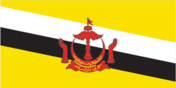
Flag
yellow with two diagonal bands of white (top, almost double width) and black starting from the upper hoist side; the national emblem in red is superimposed at the center; the emblem includes a swallow-tailed flag on top of a winged column within an upturned crescent above a scroll and flanked by two upraised hands
Highways
total: 1,090 km paved: bituminous 370 km (with another 52 km under construction) unpaved: gravel or earth 720 km
Imports
$2 billion (c.i.f., 1992 est.) commodities: machinery and transport equipment, manufactured goods, food, chemicals partners: Singapore 35%, UK 26%, Switzerland 9%, US 9%, Japan 5% (1990)
Independence
1 January 1984 (from UK)
Industrial production
growth rate 12.9% (1987); accounts for 52.4% of GDP
Industries
petroleum, petroleum refining, liquefied natural gas, construction
Infant mortality rate
25.2 deaths/1,000 live births (1994 est.)
Inflation rate (consumer prices)
2% (1993 est.)
Inland waterways
209 km; navigable by craft drawing less than 1.2 meters
International disputes
may wish to purchase the Malaysian salient that divides the country; all of the Spratly Islands are claimed by China, Taiwan, and Vietnam; parts of them are claimed by Malaysia and the Philippines; in 1984, Brunei established an exclusive fishing zone that encompasses Louisa Reef, but has not publicly claimed the island
Irrigated land
10 sq km (1989 est.)
Judicial branch
Supreme Court
Labor force
89,000 (includes members of the Army) by occupation: government 47.5%, production of oil, natural gas, services, and construction 41.9%, agriculture, forestry, and fishing 3.8% (1986) note: 33% of labor force is foreign (1988)
Land boundaries
total 381 km, Malysia 381 km
Land use
arable land: 1% permanent crops: 1% meadows and pastures: 1% forest and woodland: 79% other: 18%
Languages
Malay (official), English, Chinese
Legal system
based on Islamic law
Legislative branch
unicameral
Legislative Council (Majlis Masyuarat Megeri)
elections last held in March 1962; in 1970 the Council was changed to an appointive body by decree of the sultan; an elected legislative Council is being considered as part of constitution reform, but elections are unlikely for several years
Life expectancy at birth
total population: 71.1 years male: 69.46 years female: 72.78 years (1994 est.)
Literacy
age 15 and over can read and write (1981) total population: 77% male: 85% female: 69%
Location
Southeastern Asia, on the northern coast of Borneo almost completely surrounded by Malaysia
Manpower availability
males age 15-49 79,486; fit for military service 46,258; reach military age (18) annually 2,756 (1994 est.)
Map references
Asia, Oceania, Southeast Asia, Standard Time Zones of the World
Maritime claims
exclusive fishing zone: 200 nm territorial sea: 12 nm
Member of
APEC, ASEAN, C, ESCAP, FAO, G-77, GATT, ICAO, IDB, IMO, INTELSAT (nonsignatory user), INTERPOL, IOC, ISO (correspondent), ITU, NAM, OIC, UN, UNCTAD, UPU, UNTAC, WHO, WMO
Merchant marine
7 liquefied gas carriers (1,000 GRT or over) totaling 348,476 GRT/340,635 DWT
Names
conventional long form: Negara Brunei Darussalam conventional short form: Brunei
National holiday
National Day 23 February (1984)
National product
GDP - exchange rate conversion - $2.5 billion (1991 est.)
National product per capita
$9,000 (1991 est.)
National product real growth rate
1% (1991)
Nationality
noun: Bruneian(s) adjective: Bruneian
Natural resources
petroleum, natural gas, timber
Net migration rate
5.81 migrant(s)/1,000 population (1994 est.)
Note
close to vital sea lanes through South China Sea linking Indian and Pacific Oceans; two parts physically separated by Malaysia; almost an enclave of Malaysia
Overview
The economy is a mixture of foreign and domestic entrepreneurship, government regulation and welfare measures, and village tradition. It is almost totally supported by exports of crude oil and natural gas, with revenues from the petroleum sector accounting for more than 50% of GDP. Per capita GDP is among the highest in the Third World, and substantial income from overseas investment supplements domestic production. The government provides for all medical services and subsidizes food and housing.
Pipelines
crude oil 135 km; petroleum products 418 km; natural gas 920 km
Political parties and leaders
Brunei United National Party (inactive), Anak HASANUDDIN, chairman; Brunei National Democratic Party (the first legal political party and now banned), leader NA
Population
284,653 (July 1994 est.)
Population growth rate
2.7% (1994 est.)
Ports
Kuala Belait, Muara
Railroads
13 km 0.610-meter narrow-gauge private line
Religions
Muslim (official) 63%, Buddhism 14%, Christian 8%, indigenous beliefs and other 15% (1981)
Suffrage
none
Telecommunications
service throughout country is adequate for present needs; international service good to adjacent Malaysia; radiobroadcast coverage good; 33,000 telephones (1987); broadcast stations - 4 AM/FM, 1 TV; 74,000 radio receivers (1987); satellite earth stations - 1 Indian Ocean INTELSAT and 1 Pacific Ocean INTELSAT
Terrain
flat coastal plain rises to mountains in east; hilly lowland in west
Total fertility rate
3.43 children born/woman (1994 est.)
Type
constitutional sultanate
Unemployment rate
3.7% (1989)
US diplomatic representation
chief of mission: Ambassador Theresa A. TULL embassy: Third Floor, Teck Guan Plaza, Jalan Sultan, Bandar Seri Begawan mailing address: American Embassy Box B, APO AP 96440 telephone: [673] (2) 229-670