1995 Edition
CIA World Factbook 1995 (Project Gutenberg)
Geography
Area
total area: 60 sq km land area: 60 sq km comparative area: about 0.3 times the size of Washington, DC note: includes the island of Diego Garcia
Climate
tropical marine; hot, humid, moderated by trade winds
Coastline
698 km
Environment
current issues: NA natural hazards: NA international agreements: NA
International disputes
the entire Chagos Archipelago is claimed by Mauritius
Irrigated land
0 sq km
Land boundaries
0 km
Land use
arable land: 0% permanent crops: 0% meadows and pastures: 0% forest and woodland: 0% other: 100%
Location
Southern Asia, archipelago in the Indian Ocean, about one-half the way from Africa to Indonesia
Map references
World
Maritime claims
exclusive fishing zone: 200 nm territorial sea: 3 nm
Natural resources
coconuts, fish
Note
archipelago of 2,300 islands; Diego Garcia, largest and southernmost island, occupies strategic location in central Indian Ocean; island is site of joint US-UK military facility
Terrain
flat and low (up to 4 meters in elevation)
People and Society
Population
no indigenous inhabitants note: there are UK-US military personnel; civilian inhabitants, known as the Ilois, evacuated to Mauritius before construction of UK-US military facilities
Government
Abbreviation
BIOT
Capital
none
Digraph
IO
Diplomatic representation in US
none (dependent territory of the UK)
Executive branch
chief of state: Queen ELIZABETH II (since 6 February 1952) head of government: Commissioner Mr. D. R. MACLENNAN); Administrator Mr. David Smith; note - both reside in the UK
Flag
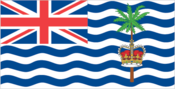
white with the flag of the UK in the upper hoist-side quadrant and six blue wavy horizontal stripes bearing a palm tree and yellow crown centered on the outer half of the flag
Independence
none (dependent territory of the UK)
Names
conventional long form: British Indian Ocean Territory conventional short form: none
Type
dependent territory of the UK
US diplomatic representation
none (dependent territory of the UK)
Economy
Electricity
provided by the US military
Overview
All economic activity is concentrated on the largest island of Diego Garcia, where joint UK-US defense facilities are located. Construction projects and various services needed to support the military installations are done by military and contract employees from the UK, Mauritius, the Philippines, and the US. There are no industrial or agricultural activities on the islands.
Communications
Radio
broadcast stations: AM 1, FM 1, shortwave 0 radios: NA
Telephone system
NA telephones; minimal facilities local: NA intercity: NA international: 1 INTELSAT (Atlantic Ocean) earth station
Television
broadcast stations: 1 televisions: NA
Transportation
Airports
total: 1 with paved runways over 3,047 m: 1
Highways
total: NA paved: short stretch of paved road between port and airfield on Diego Garcia unpaved: NA
Ports
Diego Garcia
Railroads
0 km
Military and Security
Note
defense is the responsibility of the UK ________________________________________________________________________ BRITISH VIRGIN ISLANDS (dependent territory of the UK)