2003 Edition
CIA World Factbook 2003 (Project Gutenberg)
Introduction
Administrative divisions
- 18 districts (dzongkhag, singular and plural); Bumthang, Chhukha, Chirang, Dagana, Geylegphug, Ha, Lhuntshi, Mongar, Paro, Pemagatsel, Punakha, Samchi, Samdrup Jongkhar, Shemgang, Tashigang, Thimphu, Tongsa, Wangdi Phodrang
- note
- there may be two new districts named Gasa and Yangtse
Age structure
0-14 years: 39.6% (male 438,784; female 407,919) 15-64 years: 56.4% (male 621,666; female 585,550) 65 years and over: 4% (male 43,262; female 42,368) (2003 est.)
Agriculture - products
rice, corn, root crops, citrus, foodgrains; dairy products, eggs
Airports
2 (2002)
Airports - with paved runways
- total
- 1 1,524 to 2,437 m: 1 (2002)
Airports - with unpaved runways
- total
- 1 914 to 1,523 m: 1 (2002) Military Bhutan
Area
- land
- 47,000 sq km
- total
- 47,000 sq km
- water
- 0 sq km
Area - comparative
about half the size of Indiana
Background
In 1865, Britain and Bhutan signed the Treaty of Sinchulu, under which Bhutan would receive an annual subsidy in exchange for ceding some border land. Under British influence, a monarchy was set up in 1907; three years later, a treaty was signed whereby the British agreed not to interfere in Bhutanese internal affairs and Bhutan allowed Britain to direct its foreign affairs. This role was assumed by independent India after 1947. Two years later, a formal Indo-Bhutanese accord returned the areas of Bhutan annexed by the British, formalized the annual subsidies the country received, and defined India's responsibilities in defense and foreign relations. A refugee issue of some 100,000 Bhutanese in Nepal remains unresolved; 90% of the refugees are housed in seven United Nations Office of the High Commissioner for Refugees (UNHCR) camps. Maoist Assamese separatists from India, who have established themselves in the southeast portion of Bhutan, have drawn Indian cross-border incursions. Geography Bhutan
Birth rate
34.82 births/1,000 population (2003 est.)
Budget
- expenditures
- $152 million, including capital expenditures of NA
- note
- the government of India finances nearly three-fifths of Bhutan's budget expenditures (FY95/96 est.)
- revenues
- $146 million
Capital
Thimphu
Climate
varies; tropical in southern plains; cool winters and hot summers in central valleys; severe winters and cool summers in Himalayas
Coastline
0 km (landlocked)
Constitution
no written constitution or bill of rights; note - the King commissioned a committee to draft a constitution in 2001, but has yet to be approved
Country name
- conventional long form
- Kingdom of Bhutan
- conventional short form
- Bhutan
Currency
ngultrum (BTN); Indian rupee (INR)
Currency code
BTN; INR
Death rate
13.47 deaths/1,000 population (2003 est.)
Debt - external
$245 million (2000)
Diplomatic representation from the US
the US and Bhutan have no formal diplomatic relations, although informal contact is maintained between the Bhutanese and US Embassy in New Delhi (India)
Diplomatic representation in the US
- none; note - Bhutan has a Permanent Mission to the UN; address: 2 United Nations Plaza, 27th Floor, New York, NY 10017; telephone [1] (212) 826-1919; the Bhutanese mission to the UN has consular jurisdiction in the US
- consulate(s) general
- New York
Disputes - international
approximately 100,000 Bhutanese refugees living in Nepal, 90% of whom reside in seven UN Office of the High Commissioner for Refugees camps, place decades-long strains on Nepal This page was last updated on 18 December, 2003
Economic aid - recipient
substantial aid from India and other nations
Economy - overview
The economy, one of the world's smallest and least developed, is based on agriculture and forestry, providing the main livelihood for more than 90% of the population. Agriculture consists largely of subsistence farming and animal husbandry. Rugged mountains dominate the terrain and make the building of roads and other infrastructure difficult and expensive. The economy is closely aligned with India's through strong trade and monetary links and dependence on India's financial assistance. The industrial sector is technologically backward, with most production of the cottage industry type. Most development projects, such as road construction, rely on Indian migrant labor. Bhutan's hydropower potential and its attraction for tourists are key resources. The government has made some progress in expanding the nation's productive base and improving social welfare. Model education, social, and environment programs are underway with support from multilateral development organizations. Each economic program takes into account the government's desire to protect the country's environment and cultural traditions. Detailed controls and uncertain policies in areas like industrial licensing, trade, labor, and finance continue to hamper foreign investment.
Electricity - consumption
379.5 million kWh (2001)
Electricity - exports
1.4 billion kWh (2001)
Electricity - imports
16 million kWh (2001)
Electricity - production
1.896 billion kWh (2001)
Electricity - production by source
- fossil fuel
- 0.1%
- hydro
- 99.9%
- nuclear
- 0%
- other
- 0% (2001)
Elevation extremes
- highest point
- Kula Kangri 7,553 m
- lowest point
- Drangme Chhu 97 m
Environment - current issues
soil erosion; limited access to potable water
Environment - international agreements
- party to
- Biodiversity, Climate Change, Nuclear Test Ban
- signed, but not ratified
- Law of the Sea
Ethnic groups
Bhote 50%, ethnic Nepalese 35% (includes Lhotsampas--one of several Nepalese ethnic groups), indigenous or migrant tribes 15%
Exchange rates
ngultrum per US dollar - 48.61 (2002), 47.19 (2001), 44.94 (2000), 43.06 (1999), 41.26 (1998)
Executive branch
- cabinet
- Council of Ministers (Lhengye Shungtsog) nominated by the monarch, approved by the National Assembly; members serve fixed, five-year terms; note - there is also a Royal Advisory Council (Lodoi Tsokde), members nominated by the monarch
- chief of state
- King Jigme Singye WANGCHUCK (since 24 July 1972)
- elections
- none; the monarch is hereditary, but democratic reforms in July 1998 grant the National Assembly authority to remove the monarch with two-thirds vote
- head of government
- Chairman of the Council of Ministers Lyonpo Jigme Y. THINLEY (since 30 August 2003)
Exports
$154 million f.o.b. (2000 est.)
Exports - commodities
electricity (to India), cardamom, gypsum, timber, handicrafts, cement, fruit, precious stones, spices
Exports - partners
US 24.1%, UK 23.9%, Pakistan 23.1%, France 13.9% (2002)
Fiscal year
1 July - 30 June Communications Bhutan
Flag description
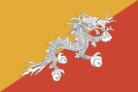
divided diagonally from the lower hoist side corner; the upper triangle is yellow and the lower triangle is orange; centered along the dividing line is a large black and white dragon facing away from the hoist side Economy Bhutan
GDP
purchasing power parity - $2.7 billion (2002 est.)
GDP - composition by sector
- agriculture
- 45%
- industry
- 10%
- services
- 45% (2002 est.)
GDP - per capita
purchasing power parity - $1,300 (2002 est.)
GDP - real growth rate
7.7% (2002 est.)
Geographic coordinates
27 30 N, 90 30 E
Geography - note
landlocked; strategic location between China and India; controls several key Himalayan mountain passes People Bhutan
Government type
monarchy; special treaty relationship with India
Highways
- paved
- 2,240 km
- total
- 3,690 km
- unpaved
- 1,450 km (1999 est.)
HIV/AIDS - adult prevalence rate
less than 0.1% (2001 est.)
HIV/AIDS - deaths
NA
HIV/AIDS - people living with HIV/AIDS
less than 100 (1999 est.)
Household income or consumption by percentage share
- highest 10%
- NA%
- lowest 10%
- NA%
Imports
$196 million c.i.f. (2000 est.)
Imports - commodities
fuel and lubricants, grain, machinery and parts, vehicles, fabrics, rice
Imports - partners
Japan 44.5%, Germany 12.2%, UK 8.5%, Singapore 6%, South Korea 5%, US 4.2% (2002)
Independence
8 August 1949 (from India)
Industrial production growth rate
9.3% (1996 est.)
Industries
cement, wood products, processed fruits, alcoholic beverages, calcium carbide
Infant mortality rate
- female
- 106.97 deaths/1,000 live births (2003 est.)
- male
- 102.49 deaths/1,000 live births
- total
- 104.68 deaths/1,000 live births
Inflation rate (consumer prices)
3% (2002 est.)
International organization participation
AsDB, CP, ESCAP, FAO, G-77, IBRD, ICAO, IDA, IFAD, IMF, IOC, IOM (observer), ITU, NAM, OPCW (signatory), SAARC, UN, UNCTAD, UNESCO, UNIDO, UPU, WCO, WHO, WIPO, WTrO (observer)
Internet country code
.bt
Internet Service Providers (ISPs)
NA
Internet users
2,500 (2002) Transportation Bhutan
Irrigated land
400 sq km (1998 est.)
Judicial branch
Supreme Court of Appeal (the monarch); High Court (judges appointed by the monarch)
Labor force
- NA
- note
- massive lack of skilled labor
Labor force - by occupation
agriculture 93%, services 5%, industry and commerce 2%
Land boundaries
- border countries
- China 470 km, India 605 km
- total
- 1,075 km
Land use
- arable land
- 2.98%
- other
- 96.59% (1998 est.)
- permanent crops
- 0.43%
Languages
Dzongkha (official), Bhotes speak various Tibetan dialects, Nepalese speak various Nepalese dialects
Legal system
based on Indian law and English common law; has not accepted compulsory ICJ jurisdiction
Legislative branch
- unicameral National Assembly or Tshogdu (150 seats; 105 elected from village constituencies, 10 represent religious bodies, and 35 are designated by the monarch to represent government and other secular interests; members serve three-year terms)
- election results
- NA
- elections
- local elections last held November 2002 (next to be held NA 2005)
Life expectancy at birth
- female
- 53.25 years (2003 est.)
- male
- 53.9 years
- total population
- 53.58 years
Literacy
- definition
- age 15 and over can read and write
- female
- 28.1% (1995 est.) Government Bhutan
- male
- 56.2%
- total population
- 42.2%
Location
Southern Asia, between China and India
Map references
Asia
Maritime claims
none (landlocked)
Median age
- female
- 20.3 years (2002)
- male
- 19.9 years
- total
- 20.1 years
Military branches
Royal Bhutan Army, Royal Bodyguard, National Militia, Royal Bhutan Police, Forest Guards
Military expenditures - dollar figure
$9.3 million (FY02)
Military expenditures - percent of GDP
1.9% (FY02) Transnational Issues Bhutan
Military manpower - availability
- males age 15-49
- 530,860 (2003 est.)
Military manpower - fit for military service
- males age 15-49
- 283,493 (2003 est.)
Military manpower - military age
18 years of age (2003 est.)
Military manpower - reaching military age annually
- males
- 22,755 (2003 est.)
National holiday
National Day (Ugyen WANGCHUCK became first hereditary king), 17 December (1907)
Nationality
- adjective
- Bhutanese
- noun
- Bhutanese (singular and plural)
Natural hazards
violent storms from the Himalayas are the source of the country's name which translates as Land of the Thunder Dragon; frequent landslides during the rainy season
Natural resources
timber, hydropower, gypsum, calcium carbide
Net migration rate
0 migrant(s)/1,000 population (2003 est.)
Oil - consumption
1,020 bbl/day (2001 est.)
Oil - exports
NA (2001)
Oil - imports
NA (2001)
Oil - production
0 bbl/day (2001 est.)
Political parties and leaders
no legal parties
Political pressure groups and leaders
Buddhist clergy; ethnic Nepalese organizations leading militant antigovernment campaign; Indian merchant community; United Front for Democracy (exiled)
Population
- 2,139,549
- note
- other estimates range as low as 810,000 (July 2003 est.)
Population below poverty line
NA%
Population growth rate
2.14% (2003 est.)
Ports and harbors
none
Radio broadcast stations
AM 0, FM 1, shortwave 1 (1998)
Radios
37,000 (1997)
Railways
0 km
Religions
Lamaistic Buddhist 75%, Indian- and Nepalese-influenced Hinduism 25%
Sex ratio
- at birth
- 1.05 male(s)/female
- total population
- 1.07 male(s)/female (2003 est.)
- under 15 years
- 1.08 male(s)/female 15-64 years: 1.06 male(s)/female 65 years and over: 1.02 male(s)/female
Suffrage
each family has one vote in village-level elections
Telephone system
- domestic
- domestic telephone service is very poor with few telephones in use
- general assessment
- NA
- international
- international telephone and telegraph service is by landline through India; a satellite earth station was planned (1990)
Telephones - main lines in use
6,000 (1997)
Telephones - mobile cellular
NA
Television broadcast stations
0 (1997)
Televisions
11,000 (1997)
Terrain
mostly mountainous with some fertile valleys and savanna
Total fertility rate
4.94 children born/woman (2003 est.)
Unemployment rate
NA%
Waterways
none