1993 Edition
CIA World Factbook 1993 (Project Gutenberg)
Geography
Area
total area: 47,000 km2 land area: 47,000 km2 comparative area: slightly more than half the size of Indiana
Climate
varies; tropical in southern plains; cool winters and hot summers in central valleys; severe winters and cool summers in Himalayas
Coastline
0 km (landlocked)
Environment
violent storms coming down from the Himalayas were the source of the country name which translates as Land of the Thunder Dragon
International disputes
none
Irrigated land
340 km2 (1989 est.)
Land boundaries
total 1,075 km, China 470 km, India 605 km
Land use
arable land: 2% permanent crops: 0% meadows and pastures: 5% forest and woodland: 70% other: 23%
Location
South Asia, in the Himalayas, between China and India
Map references
Asia, Standard Time Zones of the World
Maritime claims
none; landlocked
Natural resources
timber, hydropower, gypsum, calcium carbide, tourism potential
Note
landlocked; strategic location between China and India; controls several key Himalayan mountain passes
Terrain
mostly mountainous with some fertile valleys and savanna
People and Society
Birth rate
39.59 births/1,000 population (1993 est.)
Death rate
16.26 deaths/1,000 population (1993 est.)
Ethnic divisions
Bhote 50%, ethnic Nepalese 35%, indigenous or migrant tribes 15%
Infant mortality rate
123.3 deaths/1,000 live births (1993 est.)
Labor force
NA by occupation: agriculture 93%, services 5%, industry and commerce 2% note: massive lack of skilled labor
Languages
Dzongkha (official), Bhotes speak various Tibetan dialects; Nepalese speak various Nepalese dialects
Life expectancy at birth
total population: 50.17 years male: 50.74 years female: 49.58 years (1993 est.)
Literacy
total population: NA% male: NA% female: NA%
Nationality
noun: Bhutanese (singular and plural) adjective: Bhutanese
Net migration rate
0 migrant(s)/1,000 population (1993 est.)
Population
700,000 (July 1993 est.)
Population growth rate
2.33% (1993 est.)
Religions
Lamaistic Buddhism 75%, Indian- and Nepalese-influenced Hinduism 25%
Total fertility rate
5.45 children born/woman (1993 est.)
Government
Administrative divisions
18 districts (dzongkhag, singular and plural); Bumthang, Chhukha, Chirang, Daga, Geylegphug, Ha, Lhuntshi, Mongar, Paro, Pemagatsel, Punakha, Samchi, Samdrup Jongkhar, Shemgang, Tashigang, Thimphu, Tongsa, Wangdi Phodrang
Capital
Thimphu
Chief of State and Head of Government
King Jigme Singye WANGCHUCK (since 24 July 1972)
Constitution
no written constitution or bill of rights
Digraph
BT
Diplomatic representation in US
no formal diplomatic relations; the Bhutanese mission to the UN in New York has consular jurisdiction in the US
Elections
no national elections
Executive branch
monarch, chairman of the Royal Advisory Council, Royal Advisory Council (Lodoi Tsokde), chairman of the Council of Ministers, Council of Ministers (Lhengye Shungtsog)
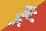
Flag
divided diagonally from the lower hoist side corner; the upper triangle is orange and the lower triangle is red; centered along the dividing line is a large black and white dragon facing away from the hoist side
Independence
8 August 1949 (from India)
Judicial branch
High Court
Legal system
based on Indian law and English common law; has not accepted compulsory ICJ jurisdiction
Legislative branch
unicameral National Assembly (Tshogdu)
Member of
AsDB, CP, ESCAP, FAO, G-77, IBRD, ICAO, IDA, IFAD, IMF, INTELSAT, IOC, ITU, NAM, SAARC, UN, UNCTAD, UNESCO, UNIDO, UPU, WHO
Names
conventional long form: Kingdom of Bhutan conventional short form: Bhutan
National holiday
National Day, 17 December (1907) (Ugyen Wangchuck became first hereditary king)
Other political or pressure groups
Buddhist clergy; Indian merchant community; ethnic Nepalese organizations leading militant antigovernment campaign
Political parties and leaders
no legal parties
Suffrage
each family has one vote in village-level elections
Type
monarchy; special treaty relationship with India
US diplomatic representation
no formal diplomatic relations, although informal contact is maintained between the Bhutanese and US Embassies in New Delhi (India)
Economy
Agriculture
accounts for 45% of GDP; based on subsistence farming and animal husbandry; self-sufficient in food except for foodgrains; other production - rice, corn, root crops, citrus fruit, dairy products, eggs
Budget
revenues $112 million; expenditures $121 million, including capital expenditures of $58 million (FY91 est.)
Currency
1 ngultrum (Nu) = 100 chetrum; note - Indian currency is also legal tender
Economic aid
Western (non-US) countries, ODA and OOF bilateral commitments (1970-89), $115 million; OPEC bilateral aid (1979-89), $11 million
Electricity
336,000 kW capacity; 1,542.2 million kWh produced, 2,203 kWh per capita (25.8% is exported to India, leaving only 1,633 kWh per capita) (1990-91)
Exchange rates
ngultrum (Nu) per US$1 - 26.156 (January 1993), 25.918 (1992), 22.742 (1991), 17.504 (1990), 16.226 (1989), 13.917 (1988); note - the Bhutanese ngultrum is at par with the Indian rupee
Exports
$74 million (f.o.b., FY91 est.) commodities: cardamon, gypsum, timber, handicrafts, cement, fruit, electricity (to India) partners: India 90%
External debt
$120 million (June 91)
Fiscal year
1 July - 30 June
Imports
$106.4 million (c.i.f., FY91 est.) commodities: fuel and lubricants, grain, machinery and parts, vehicles, fabrics partners: India 83%
Industrial production
growth rate NA%; accounts for 18% of GDP; primarily cottage industry and home based handicrafts
Industries
cement, wood products, processed fruits, alcoholic beverages, calcium carbide
Inflation rate (consumer prices)
10% (FY91 est.)
National product
GDP - exchange rate conversion - $320 million (1991 est.)
National product per capita
$200 (1991 est.)
National product real growth rate
3.1% (1991 est.)
Overview
The economy, one of the world's least developed, is based on agriculture and forestry, which provide the main livelihood for 90% of the population and account for about 50% of GDP. Rugged mountains dominate the terrain and make the building of roads and other infrastructure difficult and expensive. The economy is closely aligned with that of India through strong trade and monetary links. The industrial sector is small and technologically backward, with most production of the cottage industry type. Most development projects, such as road construction, rely on Indian migrant labor. Bhutan's hydropower potential and its attraction for tourists are its most important natural resources; however, the government limits the number of tourists to 3,000/year to minimize foreign influence.
Unemployment rate
NA%
Communications
Airports
total: 2 usable: 2 with permanent-surface runways: 1 with runways over 3,659 m: with runways 2,440-3,659 m: with runways 1,220-2,439 m: 2
Highways
2,165 km total; 1,703 km surfaced
Telecommunications
domestic telephone service is very poor with very few telephones in use; international telephone and telegraph service is by land line through India; a satellite earth station was planned (1990); broadcast stations - 1 AM, 1 FM, no TV (1990)
Military and Security
Branches
Royal Bhutan Army, Palace Guard, Militia
Defense expenditures
exchange rate conversion - $NA, NA% of GDP
Manpower availability
males age 15-49 415,315; fit for military service 222,027; reach military age (18) annually 17,344 (1993 est.)