2001 Edition
CIA World Factbook 2001 (Project Gutenberg)
Introduction
Age structure
0-14 years: 47.32% (male 1,574,124; female 1,544,741) 15-64 years: 50.38% (male 1,607,900; female 1,712,360) 65 years and over: 2.3% (male 64,756; female 86,901) (2001 est.)
Area
total: 112,620 sq km land: 110,620 sq km water: 2,000 sq km
Area - comparative
slightly smaller than Pennsylvania
Background
Dahomey gained its independence from France in 1960; the name was changed to Benin in 1975. From 1974 to 1989 the country was a socialist state; free elections were reestablished in 1991. Benin Geography
Birth rate
44.23 births/1,000 population (2001 est.)
Capital
Porto-Novo is the official capital; Cotonou is the seat of
Climate
tropical; hot, humid in south; semiarid in north
Coastline
121 km
Country name
conventional long form: Republic of Benin conventional short form: Benin local long form: Republique du Benin local short form: Benin former: Dahomey
Death rate
14.51 deaths/1,000 population (2001 est.)
Elevation extremes
lowest point: Atlantic Ocean 0 m highest point: Mont Sokbaro 658 m
Environment - current issues
inadequate supplies of potable water; poaching threatens wildlife populations; deforestation; desertification
Environment - international agreements
party to: Biodiversity, Climate Change, Desertification, Endangered Species, Environmental Modification, Hazardous Wastes, Law of the Sea, Nuclear Test Ban, Ozone Layer Protection, Ship Pollution, Wetlands signed, but not ratified: none of the selected agreements
Ethnic groups
African 99% (42 ethnic groups, most important being Fon, Adja, Yoruba, Bariba), Europeans 5,500
Geographic coordinates
9 30 N, 2 15 E
Geography - note
no natural harbors Benin People
Government type
republic under multiparty democratic rule; dropped Marxism-Leninism December 1989; democratic reforms adopted February 1990; transition to multiparty system completed 4 April 1991
HIV/AIDS - adult prevalence rate
2.45% (1999 est.)
HIV/AIDS - deaths
5,600 (1999 est.)
HIV/AIDS - people living with HIV/AIDS
70,000 (1999 est.)
Infant mortality rate
89.68 deaths/1,000 live births (2001 est.)
Irrigated land
100 sq km (1993 est.)
Land boundaries
total: 1,989 km border countries: Burkina Faso 306 km, Niger 266 km, Nigeria 773 km, Togo 644 km
Land use
arable land: 13% permanent crops: 4% permanent pastures: 4% forests and woodland: 31% other: 48% (1993 est.)
Languages
French (official), Fon and Yoruba (most common vernaculars in south), tribal languages (at least six major ones in north)
Life expectancy at birth
total population: 49.94 years male: 49.02 years female: 50.88 years (2001 est.)
Literacy
definition: age 15 and over can read and write total population: 37.5% male: 52.2% female: 23.6% (2000) Benin Government
Location
Western Africa, bordering the North Atlantic Ocean, between Nigeria and Togo
Map references
Africa
Maritime claims
territorial sea: 200 NM
Nationality
noun: Beninese (singular and plural) adjective: Beninese
Natural hazards
hot, dry, dusty harmattan wind may affect north in winter
Natural resources
small offshore oil deposits, limestone, marble, timber
Net migration rate
0 migrant(s)/1,000 population (2001 est.)
Population
6,590,782 note: estimates for this country explicitly take into account the effects of excess mortality due to AIDS; this can result in lower life expectancy, higher infant mortality and death rates, lower population and growth rates, and changes in the distribution of population by age and sex than would otherwise be expected (July 2001 est.)
Population growth rate
2.97% (2001 est.)
Religions
indigenous beliefs 50%, Christian 30%, Muslim 20%
Sex ratio
at birth: 1.03 male(s)/female under 15 years: 1.02 male(s)/female 15-64 years: 0.94 male(s)/female 65 years and over: 0.75 male(s)/female total population: 0.97 male(s)/female (2001 est.)
Terrain
mostly flat to undulating plain; some hills and low mountains
Total fertility rate
6.23 children born/woman (2001 est.)
Government
Administrative divisions
6 provinces; Atakora, Atlantique, Borgou, Mono, Oueme, Zou; note - six additional provinces have been reported but not confirmed; they are Alibori, Collines, Couffo, Donga, Littoral, and Plateau; moreover, the term "province" may have been changed to "department"
Agriculture - products
corn, sorghum, cassava (tapioca), yams, beans, rice, cotton, palm oil, peanuts; poultry, livestock
Airports
5 (2000 est.)
Airports - with paved runways
total: 1 1,524 to 2,437 m: 1 (2000 est.)
Airports - with unpaved runways
total: 4 2,438 to 3,047 m: 1 1,524 to 2,437 m: 1 914 to 1,523 m: 2 (2000 est.) Benin Military
Budget
revenues: $299 million expenditures: $445 million, including capital expenditures of $14 million (1995 est.)
Constitution
December 1990
Currency
Communaute Financiere Africaine franc (XOF); note - responsible authority is the Central Bank of the West African States
Currency code
XOF
Debt - external
$1.6 billion (1998 est.)
Diplomatic representation from the US
chief of mission: Ambassador Pamela E. BRIDGEWATER embassy: Rue Caporal Bernard Anani, Cotonou mailing address: B. P. 2012, Cotonou telephone: [229] 30-06-50, 30-05-13, 30-17-92
Diplomatic representation in the US
chief of mission: Ambassador Lucien Edgar TONOUKOUIN chancery: 2737 Cathedral Avenue NW, Washington, DC 20008 telephone: [1] (202) 232-6656
Disputes - international
none
Economic aid - recipient
$274.6 million (1997)
Economy - overview
The economy of Benin remains underdeveloped and dependent on subsistence agriculture, cotton production, and regional trade. Growth in real output averaged a sound 5% in 1996-99, but a rapid population rise offset much of this growth. Inflation has subsided over the past several years. Commercial and transport activities, which make up a large part of GDP, are vulnerable to developments in Nigeria, particularly fuel shortages. The Paris Club and bilateral creditors have eased the external debt situation in recent years. While high fuel prices constrained growth in 2000, increased cotton production - enabled by a major restructuring program - and an expansion of the Cotonou port, may lead to increased growth in 2001.
Electricity - consumption
510.2 million kWh (1999)
Electricity - exports
0 kWh (1999)
Electricity - imports
300 million kWh (1999)
Electricity - production
226 million kWh (1999)
Electricity - production by source
fossil fuel: 24.78% hydro: 75.22% nuclear: 0% other: 0% (1999)
Exchange rates
Communaute Financiere Africaine francs (XOF) per US dollar - 699.21 (January 2001), 711.98 (2000), 615.70 (1999), 589.95 (1998), 583.67 (1997), 511.55 (1996); note - from 1 January 1999, the XOF is pegged to the euro at a rate of 655.957 XOF per euro
Executive branch
chief of state: President Mathieu KEREKOU (since 4 April 1996); note - the president is both the chief of state and head of government head of government: President Mathieu KEREKOU (since 4 April 1996); note - the president is both the chief of state and head of
Exports
$396 million (f.o.b., 1999)
Exports - commodities
cotton, crude oil, palm products, cocoa
Exports - partners
Brazil 14%, Libya 5%, Indonesia 4%, Italy 4% (1999)
FAX
- [1] (202) 265-1996
- [229] 30-14-39, 30-19-74
Fiscal year
calendar year Benin Communications
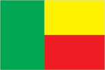
Flag description
two equal horizontal bands of yellow (top) and red with a vertical green band on the hoist side Benin Economy
GDP
purchasing power parity - $6.6 billion (2000 est.)
GDP - composition by sector
agriculture: 37.9% industry: 13.5% services: 48.6% (1999)
GDP - per capita
purchasing power parity - $1,030 (2000 est.)
GDP - real growth rate
5% (2000 est.)
Highways
total: 6,787 km paved: 1,357 km (including 10 km of expressways) unpaved: 5,430 km (1997 est.)
Household income or consumption by percentage share
lowest 10%: NA% highest 10%: NA%
Illicit drugs
transshipment point for narcotics associated with Nigerian trafficking organizations and most commonly destined for Western Europe and the US
Imports
$566 million (c.i.f., 1999)
Imports - commodities
foodstuffs, tobacco, petroleum products, capital goods
Imports - partners
France 38%, China 16%, UK 9%, Cote d'Ivoire 5% (1999)
Independence
1 August 1960 (from France)
Industrial production growth rate
6.9% (2000 est.)
Industries
textiles, cigarettes; beverages, food; construction materials, petroleum
Inflation rate (consumer prices)
3% (2000 est.)
International organization participation
ACCT, ACP, AfDB, CCC, ECA, ECOWAS, Entente, FAO, FZ, G-77, IAEA, IBRD, ICAO, ICFTU, ICRM, IDA, IDB, IFAD, IFC, IFRCS, ILO, IMF, IMO, Intelsat, Interpol, IOC, IOM, ISO (subscriber), ITU, MIPONUH, MONUC, NAM, OAU, OIC, OPCW, UN, UNCTAD, UNESCO, UNIDO, UNMEE, UNTAET, UPU, WADB, WADB (regional), WAEMU, WCL, WFTU, WHO, WIPO, WMO, WToO, WTrO
Internet country code
.bj
Internet Service Providers (ISPs)
1 (2000)
Internet users
10,000 (2000) Benin Transportation
Judicial branch
Constitutional Court or Cour Constitutionnelle; Supreme Court or Cour Supreme; High Court of Justice
Labor force
NA
Legal system
based on French civil law and customary law; has not accepted compulsory ICJ jurisdiction
Legislative branch
unicameral National Assembly or Assemblee Nationale (83 seats; members are elected by direct popular vote to serve four-year terms) elections: last held 30 March 1999 (next to be held NA March 2003) election results: percent of vote by party - NA%; seats by party - RB 27, PRD 11, FARD-ALAFIA 10, PSD 9, MADEP 6, E'toile 4, Alliance IPD 4, Car-DUNYA 3, MERCI 2, other 7
Merchant marine
none (2000 est.)
Military branches
Armed Forces (includes Army, Navy, Air Force), National Gendarmerie
Military expenditures - dollar figure
$27 million (FY96)
Military expenditures - percent of GDP
1.2% (FY96) Benin Transnational Issues
Military manpower - availability
males age 15-49: 1,455,433 females age 15-49: 1,489,947 note: both sexes are liable for military service (2001 est.)
Military manpower - fit for military service
males age 15-49: 743,980 females age 15-49: 755,149 (2001 est.)
Military manpower - military age
18 years of age
Military manpower - reaching military age annually
males: 70,088 females: 73,618 (2001 est.)
National holiday
National Day, 1 August (1960)
Political parties and leaders
African Movement for Democracy and Progress or MADEP [Sefou FAGBOHOUN]; Alliance for Democracy and Progress or ADP [Sylvain Adekpedjou AKINDES]; Alliance of the Social Democratic Party or PSD and the National Union for Solidarity and Progress or UNSP [Bruno AMOUSSOU]; Cameleon Alliance or AC [leader NA]; Car-DUNYA [Saka SALEY]; Communist Party of Benin or PCB [Pascal FANTONDJI, first secretary]; Democratic Renewal Party or PRD [Adrien HOUNGBEDJI]; Front for Renewal and Development or FARD-ALAFIA [Jerome Sakia KINA]; Impulse for Progress and Democracy or IPD [Bertin BORNA]; Liberal Democrats' Rally for National Reconstruction-Vivoten or RDL-Vivoten [Severin ADJOVI]; Movement for Citizens' Commitment and Awakening or MERCI [Severin ADJOVI]; New Generation for the Republic or NGR [Paul DOSSOU]; Our Common Cause or NCC [Francois Odjo TANKPINON]; Party Democratique du Benin or PDB [Col. Soule DANKORO]; Rally for Democracy and Pan-Africanism or RDP [Dominique HOYMINOU, Dr. Giles Auguste MINONTIN]; Renaissance Party du Benin or RB [Nicephore SOGLO]; The Star Alliance (Alliance E'toile) [Sacca LAFIA]; Union for National Democracy and Solidarity or UDS [Adamou N'Diaye MAMA] note: the Coalition of Democratic Forces is an alliance of parties and organizations supporting President KEREKOU [Gatien HOUNGBEDJI]
Political pressure groups and leaders
NA
Population below poverty line
37.2% (1999 est.)
Ports and harbors
Cotonou, Porto-Novo
Radio broadcast stations
AM 2, FM 9, shortwave 4 (1998)
Radios
620,000 (1997)
Railways
total: 578 km (single track) narrow gauge: 578 km 1.000-m gauge (2000)
Suffrage
18 years of age; universal
Telephone system
general assessment: NA domestic: fair system of open wire, microwave radio relay, and cellular connections international: satellite earth station - 1 Intelsat (Atlantic Ocean); submarine cable
Telephones - main lines in use
36,000 (1997)
Telephones - mobile cellular
4,295 (1997)
Television broadcast stations
2 (one privately-owned) (1997)
Televisions
60,000 (1997)
Unemployment rate
NA%
Waterways
streams navigable along small sections, important only locally