2012 Edition
CIA World Factbook 2012 Archive (HTML)
Introduction
Background
Belize was the site of several Mayan city states until their decline at the end of the first millennium A.D. The British and Spanish disputed the region in the 17th and 18th centuries; it formally became the colony of British Honduras in 1854. Territorial disputes between the UK and Guatemala delayed the independence of Belize until 1981. Guatemala refused to recognize the new nation until 1992 and the two countries are involved in an ongoing border dispute. Guatemala and Belize plan to hold a simultaneous referendum, tentatively set for October 2013, to determine if this dispute will go before the International Court of Justice at The Hague. Tourism has become the mainstay of the economy. Current concerns include the country's heavy foreign debt burden, high unemployment, growing involvement in the Mexican and South American drug trade, high crime rates, and one of the highest prevalence rates of HIV/AIDS in Central America.
Geography
Area
- 22,966 sq km 22,806 sq km 160 sq km
- total
- 22,966 sq km
- water
- 160 sq km
Area - comparative
slightly smaller than Massachusetts
Climate
tropical; very hot and humid; rainy season (May to November); dry season (February to May)
Coastline
386 km
Elevation extremes
- Caribbean Sea 0 m Doyle's Delight 1,160 m
- highest point
- Doyle's Delight 1,160 m
- lowest point
- Caribbean Sea 0 m
Environment - current issues
deforestation; water pollution from sewage, industrial effluents, agricultural runoff; solid and sewage waste disposal
Environment - international agreements
- Biodiversity, Climate Change, Climate Change-Kyoto Protocol, Desertification, Endangered Species, Hazardous Wastes, Law of the Sea, Ozone Layer Protection, Ship Pollution, Wetlands, Whaling none of the selected agreements
- party to
- Biodiversity, Climate Change, Climate Change-Kyoto Protocol, Desertification, Endangered Species, Hazardous Wastes, Law of the Sea, Ozone Layer Protection, Ship Pollution, Wetlands, Whaling
- signed, but not ratified
- none of the selected agreements
Freshwater withdrawal (domestic/industrial/agricultural)
- 0.15 cu km/yr (7%/73%/20%) 556 cu m/yr (2000)
- per capita
- 556 cu m/yr (2000)
- total
- 0.15 cu km/yr (7%/73%/20%)
Geographic coordinates
17 15 N, 88 45 W
Geography - note
only country in Central America without a coastline on the North Pacific Ocean
Irrigated land
40 sq km (2003)
Land boundaries
- 516 km Guatemala 266 km, Mexico 250 km
- border countries
- Guatemala 266 km, Mexico 250 km
- total
- 516 km
Land use
- 3.05% 1.39% 95.56% (2005)
- arable land
- 3.05%
- other
- 95.56% (2005)
- permanent crops
- 1.39%
Location
Central America, bordering the Caribbean Sea, between Guatemala and Mexico
Map references
Central America and the Caribbean
Maritime claims
- 12 nm in the north, 3 nm in the south; note - from the mouth of the Sarstoon River to Ranguana Cay, Belize's territorial sea is 3 nm; according to Belize's Maritime Areas Act, 1992, the purpose of this limitation is to provide a framework for negotiating a definitive agreement on territorial differences with Guatemala 200 nm
- exclusive economic zone
- 200 nm
- territorial sea
- 12 nm in the north, 3 nm in the south; note - from the mouth of the Sarstoon River to Ranguana Cay, Belize's territorial sea is 3 nm; according to Belize's Maritime Areas Act, 1992, the purpose of this limitation is to provide a framework for negotiating a definitive agreement on territorial differences with Guatemala
Natural hazards
frequent, devastating hurricanes (June to November) and coastal flooding (especially in south)
Natural resources
arable land potential, timber, fish, hydropower
Terrain
flat, swampy coastal plain; low mountains in south
Total renewable water resources
18.6 cu km (2000)
People and Society
Age structure
- 36.3% (male 60,730/ female 58,313) 60.1% (male 99,683/ female 97,321) 3.6% (male 5,538/ female 6,134) (2012 est.)
- 0-14 years
- 36.3% (male 60,730/ female 58,313)
- 15-64 years
- 60.1% (male 99,683/ female 97,321)
- 65 years and over
- 3.6% (male 5,538/ female 6,134) (2012 est.)
Birth rate
26.02 births/1,000 population (2012 est.)
Children under the age of 5 years underweight
4.9% (2006)
Death rate
5.91 deaths/1,000 population (July 2012 est.)
Demographic profile
Migration continues to transform Belize's population. About 16% of Belizeans live abroad, while immigrants constitute approximately 15% of Belize's population. Belizeans seeking job and educational opportunities have preferred to emigrate to the United States rather than former colonizer Great Britain because of the United States' closer proximity and stronger trade ties with Belize. Belizeans also emigrate to Canada, Mexico, and English-speaking Caribbean countries. The emigration of a large share of Creoles (Afro-Belizeans) and the influx of Central American immigrants, mainly Guatemalans, Salvadorans, and Hondurans, has changed Belize's ethnic composition. Mestizos have become the largest ethnic group, and Belize now has more native Spanish speakers than English or Creole speakers, despite English being the official language. In addition, Central American immigrants are establishing new communities in rural areas, which contrasts with the urbanization trend seen in neighboring countries. Recently, Chinese, European, and North American immigrants have become more frequent. Immigration accounts for an increasing share of Belize's population growth rate, which is steadily falling due to fertility decline. Belize's declining birth rate and its increased life expectancy are creating an aging population. As the elderly population grows and nuclear families replace extended households, Belize's government will be challenged to balance a rising demand for pensions, social services, and healthcare for its senior citizens with the need to reduce poverty and social inequality and to improve sanitation.
Education expenditures
5.7% of GDP (2008)
Ethnic groups
mestizo 48.7%, Creole 24.9%, Maya 10.6%, Garifuna 6.1%, other 9.7% (2000 census)
Health expenditures
3.3% of GDP (2009)
HIV/AIDS - adult prevalence rate
2.3% (2009 est.)
HIV/AIDS - deaths
fewer than 500 (2009 est.)
HIV/AIDS - people living with HIV/AIDS
4,800 (2009 est.)
Hospital bed density
1.1 beds/1,000 population (2009)
Infant mortality rate
- 21.37 deaths/1,000 live births 23.85 deaths/1,000 live births 18.78 deaths/1,000 live births (2012 est.)
- female
- 18.78 deaths/1,000 live births (2012 est.)
- total
- 21.37 deaths/1,000 live births
Languages
Spanish 46%, Creole 32.9%, Mayan dialects 8.9%, English 3.9% (official), Garifuna 3.4% (Carib), German 3.3%, other 1.4%, unknown 0.2% (2000 census)
Life expectancy at birth
- 68.28 years 66.61 years 70.04 years (2012 est.)
- female
- 70.04 years (2012 est.)
- total population
- 68.28 years
Literacy
- age 15 and over can read and write 76.9% 76.7% 77.1% (2000 census)
- definition
- age 15 and over can read and write
- female
- 77.1% (2000 census)
- male
- 76.7%
- total population
- 76.9%
Major cities - population
BELMOPAN (capital) 20,000 (2009)
Major infectious diseases
- high bacterial diarrhea, hepatitis A, and typhoid fever dengue fever and malaria leptospirosis (2009)
- degree of risk
- high
- food or waterborne diseases
- bacterial diarrhea, hepatitis A, and typhoid fever
- vectorborne diseases
- dengue fever and malaria
- water contact disease
- leptospirosis (2009)
Maternal mortality rate
53 deaths/100,000 live births (2010)
Median age
- 21.3 years 21.1 years 21.5 years (2012 est.)
- female
- 21.5 years (2012 est.)
- male
- 21.1 years
- total
- 21.3 years
Nationality
- Belizean(s) Belizean
- adjective
- Belizean
- noun
- Belizean(s)
Net migration rate
0 migrant(s)/1,000 population (2012 est.)
Physicians density
0.828 physicians/1,000 population (2009)
Population
327,719 (July 2012 est.)
Population growth rate
2.011% (2012 est.)
Religions
Roman Catholic 39.3%, Pentacostal 8.3%, Seventh Day Adventist 5.3%, Anglican 4.5%, Mennonite 3.7%, Baptist 3.5%, Methodist 2.8%, Nazarene 2.8%, Jehovah's Witnesses 1.6%, other 9.9% (includes Bahai Faith, Buddhism, Hinduism, Islam, and Mormon), other (unknown) 3.1%, none 15.2% (2010 census)
Sanitation facility access
- urban: 93% of population rural: 86% of population total: 90% of population urban: 7% of population rural: 14% of population total: 10% of population
- rural
- 14% of population
- total
- 10% of population
- urban
- 7% of population
School life expectancy (primary to tertiary education)
- 12 years 12 years 13 years (2009)
- female
- 13 years (2009)
- male
- 12 years
- total
- 12 years
Sex ratio
- 1.05 male(s)/female 1.04 male(s)/female 1.02 male(s)/female 0.9 male(s)/female 1.03 male(s)/female (2011 est.)
- 15-64 years
- 1.02 male(s)/female
- 65 years and over
- 0.9 male(s)/female
- at birth
- 1.05 male(s)/female
- total population
- 1.03 male(s)/female (2011 est.)
- under 15 years
- 1.04 male(s)/female
Total fertility rate
3.15 children born/woman (2012 est.)
Unemployment, youth ages 15-24
- 19.5% 13.8% 28.8% (2005)
- female
- 28.8% (2005)
- total
- 19.5%
Urbanization
- 52% of total population (2010) 2.7% annual rate of change (2010-15 est.)
- rate of urbanization
- 2.7% annual rate of change (2010-15 est.)
- urban population
- 52% of total population (2010)
Government
Administrative divisions
6 districts; Belize, Cayo, Corozal, Orange Walk, Stann Creek, Toledo
Capital
- Belmopan 17 15 N, 88 46 W UTC-6 (1 hour behind Washington, DC during Standard Time)
- geographic coordinates
- 17 15 N, 88 46 W
- name
- Belmopan
- time difference
- UTC-6 (1 hour behind Washington, DC during Standard Time)
Constitution
21 September 1981
Country name
- none Belize British Honduras
- conventional long form
- none
- conventional short form
- Belize
- former
- British Honduras
Diplomatic representation from the US
- Ambassador Vinai THUMMALAPALLY Floral Park Road, Belmopan City, Cayo District P.O. Box 497, Belmopan City, Cayo District, Belize [501] 822-4011 [501] 822-4012
- chief of mission
- Ambassador Vinai THUMMALAPALLY
- embassy
- Floral Park Road, Belmopan City, Cayo District
- FAX
- [501] 822-4012
- mailing address
- P.O. Box 497, Belmopan City, Cayo District, Belize
- telephone
- [501] 822-4011
Diplomatic representation in the US
- Ambassador Nestor MENDEZ 2535 Massachusetts Avenue NW, Washington, DC 20008 [1] (202) 332-9636 [1] (202) 332-6888 Los Angeles
- chancery
- 2535 Massachusetts Avenue NW, Washington, DC 20008
- chief of mission
- Ambassador Nestor MENDEZ
- consulate(s) general
- Los Angeles
- FAX
- [1] (202) 332-6888
- telephone
- [1] (202) 332-9636
Executive branch
- Queen ELIZABETH II (since 6 February 1952); represented by Governor General Sir Colville YOUNG, Sr. (since 17 November 1993) Prime Minister Dean Oliver BARROW (since 8 February 2008); Deputy Prime Minister Gaspar VEGA (since 12 February 2008) Cabinet appointed by the governor general on the advice of the prime minister from the General Assembly the monarchy is hereditary; governor general appointed by the monarch; following legislative elections, the leader of the majority party or the leader of the majority coalition usually appointed prime minister by the governor general; prime minister recommends the deputy prime minister
- cabinet
- Cabinet appointed by the governor general on the advice of the prime minister from the General Assembly
- chief of state
- Queen ELIZABETH II (since 6 February 1952); represented by Governor General Sir Colville YOUNG, Sr. (since 17 November 1993)
- elections
- the monarchy is hereditary; governor general appointed by the monarch; following legislative elections, the leader of the majority party or the leader of the majority coalition usually appointed prime minister by the governor general; prime minister recommends the deputy prime minister
- head of government
- Prime Minister Dean Oliver BARROW (since 8 February 2008); Deputy Prime Minister Gaspar VEGA (since 12 February 2008)
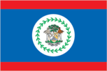
Flag description
- blue with a narrow red stripe along the top and the bottom edges; centered is a large white disk bearing the coat of arms; the coat of arms features a shield flanked by two workers in front of a mahogany tree with the related motto SUB UMBRA FLOREO (I Flourish in the Shade) on a scroll at the bottom, all encircled by a green garland of 50 mahogany leaves; the colors are those of the two main political parties: blue for the PUP and red for the UDP; various elements of the coat of arms - the figures, the tools, the mahogany tree, and the garland of leaves - recall the logging industry that led to British settlement of Belize Belize's flag is the only national flag that depicts human beings; two British overseas territories, Montserrat and the British Virgin Islands, also depict humans
- blue with a narrow red stripe along the top and the bottom edges; centered is a large white disk bearing the coat of arms; the coat of arms features a shield flanked by two workers in front of a mahogany tree with the related motto SUB UMBRA FLOREO (I Flo
- blue for the PUP and red for the UDP; various elements of the coat of arms - the figures, the tools, the mahogany tree, and the garland of leaves - recall the logging industry that led to British settlement of Belize
Government type
parliamentary democracy and a Commonwealth realm
Independence
21 September 1981 (from the UK)
International law organization participation
has not submitted an ICJ jurisdiction declaration; accepts ICCt jurisdiction
International organization participation
ACP, AOSIS, C, Caricom, CD, CDB, CELAC, FAO, G-77, IADB, IAEA, IBRD, ICAO, ICC (NGOs), ICRM, IDA, IFAD, IFC, IFRCS, ILO, IMF, IMO, Interpol, IOC, IOM, ITU, LAES, MIGA, NAM, OAS, OPANAL, OPCW, PCA, Petrocaribe, SICA, UN, UNCTAD, UNESCO, UNIDO, UPU, WCO, WHO, WIPO, WMO, WTO
Judicial branch
Supreme Court (the chief justice is appointed by the governor general on the advice of the prime minister); Court of Appeal; Privy Council in the UK; member of the Caribbean Court of Justice (CCJ); Summary Jurisdiction Courts (criminal) and District Courts (civil jurisdiction)
Legal system
English common law
Legislative branch
- bicameral National Assembly consists of the Senate (12 seats; members appointed by the governor general - 6 on the advice of the prime minister, 3 on the advice of the leader of the opposition, and 1 each on the advice of the Belize Council of Churches and Evangelical Association of Churches, the Belize Chamber of Commerce and Industry and the Belize Better Business Bureau, and the National Trade Union Congress and the Civil Society Steering Committee; to serve five-year terms) and the House of Representatives (31 seats; members are elected by direct popular vote to serve five-year terms) House of Representatives - last held on 8 March 2012 (next to be held in 2017) percent of vote by party - UDP 50.4%, PUP 47.5%, other 2.8%; seats by party - UDP 17, PUP 14
- election results
- percent of vote by party - UDP 50.4%, PUP 47.5%, other 2.8%; seats by party - UDP 17, PUP 14
- elections
- House of Representatives - last held on 8 March 2012 (next to be held in 2017)
National anthem
- "Land of the Free" Samuel Alfred HAYNES/Selwyn Walford YOUNG adopted 1981; as a Commonwealth country, in addition to the national anthem, "God Save the Queen" serves as the royal anthem (see United Kingdom)
- lyrics/music
- Samuel Alfred HAYNES/Selwyn Walford YOUNG
- name
- "Land of the Free"
National holiday
Independence Day, 21 September (1981)
National symbol(s)
Baird's tapir (a large, browsing, forest-dwelling mammal); keel-billed toucan
Political parties and leaders
National Alliance for Belizean Rights or NABR; National Reform Party or NRP [Cornelius DUECK]; People's National Party or PNP [Wil MAHEIA]; People's United Party or PUP [John BRICENO]; United Democratic Party or UDP [Dean BARROW]; Vision Inspired by the People or VIP [Paul MORGAN]; We the People Reform Movement or WTP [Hipolito BAUTISTA]
Political pressure groups and leaders
Society for the Promotion of Education and Research or SPEAR [Nicole HAYLOCK]; Association of Concerned Belizeans or ACB [David VASQUEZ]; National Trade Union Congress of Belize or NTUC/B [Rene GOMEZ]
Suffrage
18 years of age; universal
Economy
Agriculture - products
bananas, cacao, citrus, sugar; fish, cultured shrimp; lumber
Budget
- $450 million $450 million (2012 est.)
- expenditures
- $450 million (2012 est.)
- revenues
- $450 million
Budget surplus (+) or deficit (-)
0% of GDP (2012 est.)
Central bank discount rate
18% (31 December 2010 est.) 12% (31 December 2009 est.)
Commercial bank prime lending rate
13.7% (31 December 2012 est.) 13.36% (31 December 2011 est.)
Current account balance
-$59.5 million (2012 est.) -$31.3 million (2011 est.)
Debt - external
$1.457 billion (31 December 2012 est.) $1.398 billion (31 December 2011 est.)
Economy - overview
Tourism is the number one foreign exchange earner in this small economy, followed by exports of marine products, citrus, cane sugar, bananas, and garments. The government's expansionary monetary and fiscal policies, initiated in September 1998, led to GDP growth averaging nearly 4% in 1999-2007. Oil discoveries in 2006 bolstered this growth. Exploration efforts have continued and production has increased a small amount. Growth slipped to 0% in 2009, and has remained at just over 2% per year during 2010-12, as a result of the global slowdown, natural disasters, and a temporary drop in the price of oil. With weak economic growth and a large public debt burden, fiscal spending is likely to be tight. In September 2012, the government defaulted on a $23 million payment on its global bond and is in talks with international bondholders to restructure the debt. The $544 million global bond due in 2029 - called the superbond because it was the product in 2007 of a debt consolidation - represents one-half of the country's public debt. A key government objective remains the reduction of poverty and inequality with the help of international donors. Although Belize has the second highest per capita income in Central America, the average income figure masks a huge income disparity between rich and poor. The 2010 Poverty Assessment shows that more than 4 out of 10 people live in poverty. The sizable trade deficit and heavy foreign debt burden continue to be major concerns.
Exchange rates
Belizean dollars (BZD) per US dollar - 2 (2012 est.) 2 (2011 est.) 2 (2010 est.) 2 (2009) 2 (2008)
Exports
$555.8 million (2012 est.) $603.3 million (2011 est.)
Exports - commodities
sugar, bananas, citrus, clothing, fish products, molasses, wood, crude oil
Exports - partners
US 38.1%, UK 16.5%, Costa Rica 10%, Nigeria 4.4% (2011)
Fiscal year
1 April - 31 March
GDP - composition by sector
- 9.7% 19.4% 59% (2012 est.)
- agriculture
- 9.7%
- industry
- 19.4%
- services
- 59% (2012 est.)
GDP - per capita (PPP)
$8,400 (2012 est.) $8,400 (2011 est.) $8,400 (2010 est.) data are in 2012 US dollars
GDP - real growth rate
2.3% (2012 est.) 2% (2011 est.) 2.7% (2010 est.)
GDP (official exchange rate)
$1.52 billion (2012 est.)
GDP (purchasing power parity)
$2.896 billion (2012 est.) $2.831 billion (2011 est.) $2.776 billion (2010 est.) data are in 2012 US dollars
Household income or consumption by percentage share
- NA% NA%
- highest 10%
- NA%
- lowest 10%
- NA%
Imports
$770.1 million (2012 est.) $773.9 million (2011 est.)
Imports - commodities
machinery and transport equipment, manufactured goods; fuels, chemicals, pharmaceuticals; food, beverages, tobacco
Imports - partners
US 38.2%, Mexico 10.2%, Cuba 9.2%, Guatemala 5.4%, China 5%, Trinidad and Tobago 4.1% (2011)
Industrial production growth rate
1.4% (2010 est.)
Inflation rate (consumer prices)
2.8% (2012 est.) -2.5% (2011 est.)
Investment (gross fixed)
26.4% of GDP (2012 est.)
Labor force
120,500 shortage of skilled labor and all types of technical personnel (2008 est.)
Labor force - by occupation
- 10.2% 18.1% 71.7% (2007 est.)
- agriculture
- 10.2%
- industry
- 18.1%
- services
- 71.7% (2007 est.)
Market value of publicly traded shares
$NA
Population below poverty line
43% (2010 est.)
Public debt
90.8% of GDP (2012 est.) 88.5% of GDP (2011 est.)
Reserves of foreign exchange and gold
$238.9 million (31 December 2012 est.) $237.1 million (31 December 2011 est.)
Stock of broad money
$1.263 billion (31 December 2012 est.) $1.101 billion (31 December 2011 est.)
Stock of domestic credit
$1.1 billion (31 December 2012 est.) $968 million (31 December 2011 est.)
Stock of narrow money
$426.4 million (31 December 2012 est.) $419.6 million (31 December 2011 est.)
Taxes and other revenues
29.6% of GDP (2012 est.)
Unemployment rate
13.1% (2009) 8.2% (2008)
Energy
Carbon dioxide emissions from consumption of energy
980,500 Mt (2010 est.)
Crude oil - exports
0 bbl/day (2009 est.)
Crude oil - imports
0 bbl/day (2009 est.)
Crude oil - production
4,000 bbl/day (2011 est.)
Crude oil - proved reserves
6.7 million bbl (1 January 2012 est.)
Electricity - consumption
285.7 million kWh (2009 est.)
Electricity - exports
0 kWh (2010 est.)
Electricity - from fossil fuels
33.3% of total installed capacity (2009 est.)
Electricity - from hydroelectric plants
37.2% of total installed capacity (2009 est.)
Electricity - from nuclear fuels
0% of total installed capacity (2009 est.)
Electricity - from other renewable sources
29.5% of total installed capacity (2009 est.)
Electricity - imports
0 kWh (2010 est.)
Electricity - installed generating capacity
102,100 kW (2009 est.)
Electricity - production
307.2 million kWh (2009 est.)
Natural gas - consumption
0 cu m (2010 est.)
Natural gas - exports
0 cu m (2010 est.)
Natural gas - imports
0 cu m (2010 est.)
Natural gas - production
0 cu m (2010 est.)
Natural gas - proved reserves
0 cu m (1 January 2012 est.)
Refined petroleum products - consumption
7,044 bbl/day (2011 est.)
Refined petroleum products - exports
0 bbl/day (2008 est.)
Refined petroleum products - imports
3,553 bbl/day (2008 est.)
Refined petroleum products - production
0 bbl/day (2008 est.)
Communications
Broadcast media
8 privately-owned TV stations; multi-channel cable TV provides access to foreign stations; about 25 radio stations broadcasting on roughly 50 different frequencies; state-run radio was privatized in 1998 (2007)
Internet country code
.bz
Internet hosts
3,392 (2012)
Internet users
36,000 (2009)
Telephone system
- above-average system; trunk network depends primarily on microwave radio relay fixed-line teledensity of slightly less than 10 per 100 persons; mobile-cellular teledensity approaching 70 per 100 persons country code - 501; landing point for the Americas Region Caribbean Ring System (ARCOS-1) fiber-optic telecommunications submarine cable that provides links to South and Central America, parts of the Caribbean, and the US; satellite earth station - 8 (Intelsat - 2, unknown - 6) (2011)
- domestic
- fixed-line teledensity of slightly less than 10 per 100 persons; mobile-cellular teledensity approaching 70 per 100 persons
- general assessment
- above-average system; trunk network depends primarily on microwave radio relay
- international
- country code - 501; landing point for the Americas Region Caribbean Ring System (ARCOS-1) fiber-optic telecommunications submarine cable that provides links to South and Central America, parts of the Caribbean, and the US; satellite earth station - 8 (Intelsat - 2, unknown - 6) (2011)
Telephones - main lines in use
28,800 (2011)
Telephones - mobile cellular
222,000 (2011)
Transportation
Airports
43 (2012)
Airports - with paved runways
- 3 (2012)
- 2,438 to 3,047 m
- 1
- 914 to 1,523 m
- 2
- total
- 6
- under 914 m
- 3 (2012)
Airports - with unpaved runways
- 26 (2012)
- 2,438 to 3,047 m
- 1
- 914 to 1,523 m
- 10
- total
- 37
- under 914 m
- 26 (2012)
Merchant marine
- barge carrier 1, bulk carrier 33, cargo 156, chemical tanker 2, liquefied gas 1, passenger/cargo 4, petroleum tanker 9, refrigerated cargo 30, roll on/roll off 10, specialized tanker 1 152 (Bulgaria 1, China 61, Croatia 1, Estonia 1, Greece 2, Iceland 1, Italy 3, Latvia 9, Lithuania 1, Netherlands 1, Norway 2, Russia 30, Singapore 4, Switzerland 1, Syria 4, Thailand 1, Turkey 16, UAE 3, UK 4, Ukraine 6) (2010)
- foreign-owned
- 152 (Bulgaria 1, China 61, Croatia 1, Estonia 1, Greece 2, Iceland 1, Italy 3, Latvia 9, Lithuania 1, Netherlands 1, Norway 2, Russia 30, Singapore 4, Switzerland 1, Syria 4, Thailand 1, Turkey 16, UAE 3, UK 4, Ukraine 6) (2010)
- total
- 247
Ports and terminals
Belize City, Big Creek
Roadways
- 3,007 km 575 km 2,432 km (2006)
- total
- 3,007 km
- unpaved
- 2,432 km (2006)
Waterways
825 km (navigable only by small craft) (2011)
Military and Security
Manpower available for military service
- 81,284 79,185 (2010 est.)
- females age 16-49
- 79,185 (2010 est.)
- males age 16-49
- 81,284
Manpower fit for military service
- 59,431 57,221 (2010 est.)
- females age 16-49
- 57,221 (2010 est.)
- males age 16-49
- 59,431
Manpower reaching militarily significant age annually
- 3,723 3,584 (2010 est.)
- female
- 3,584 (2010 est.)
- male
- 3,723
Military branches
- Belize Defense Force (BDF): Army, BDF Air Wing (includes Special Boat Unit), BDF Volunteer Guard (2011)
- Belize Defense Force (BDF)
- Army, BDF Air Wing (includes Special Boat Unit), BDF Volunteer Guard (2011)
Military expenditures
1.4% of GDP (2009)
Military service age and obligation
- 18 years of age for voluntary military service; laws allow for conscription only if volunteers are insufficient; conscription has never been implemented; volunteers typically outnumber available positions by 3:1; initial service obligation 12 years (2012)
- 18 years of age for voluntary military service; laws allow for conscription only if volunteers are insufficient; conscription has never been implemented; volunteers typically outnumber available positions by 3
- 1; initial service obligation 12 years (2012)
Transnational Issues
Disputes - international
Guatemala persists in its territorial claim to half of Belize, but agrees to the Line of Adjacency to keep Guatemalan squatters out of Belize's forested interior; both countries agreed in April 2012 to hold simultaneous referenda, scheduled for 6 October 2013, to decide whether to refer the dispute to the ICJ for binding resolution; Belize and Mexico are working to solve minor border demarcation discrepancies arising from inaccuracies in the 1898 border treaty
Illicit drugs
transshipment point for cocaine; small-scale illicit producer of cannabis, primarily for local consumption; offshore sector money-laundering activity related to narcotics trafficking and other crimes (2008)