2010 Edition
CIA World Factbook 2010 (Project Gutenberg)
Introduction
Background
Europeans began to set up trading posts in the area of Bangladesh in the 16th century; eventually the British came to dominate the region and it became part of British India. In 1947, West Pakistan and East Bengal (both primarily Muslim) separated from India (largely Hindu) and jointly became the new country of Pakistan. East Bengal became East Pakistan in 1955, but the awkward arrangement of a two-part country with its territorial units separated by 1,600 km left the Bengalis marginalized and dissatisfied. East Pakistan seceded from its union with West Pakistan in 1971 and was renamed Bangladesh. A military-backed, emergency caretaker regime suspended parliamentary elections planned for January 2007 in an effort to reform the political system and root out corruption. In contrast to the strikes and violent street rallies that had marked Bangladeshi politics in previous years, the parliamentary elections finally held in late December 2008 were mostly peaceful and Sheikh HASINA Wajed was elected prime minister. About a third of this extremely poor country floods annually during the monsoon rainy season, hampering economic development.
Geography
Area
- land
- 130,168 sq km
- total
- 143,998 sq km
- water
- 13,830 sq km
Area - comparative
slightly smaller than Iowa
Climate
tropical; mild winter (October to March); hot, humid summer (March to June); humid, warm rainy monsoon (June to October)
Coastline
580 km
Elevation extremes
- highest point
- Keokradong 1,230 m
- lowest point
- Indian Ocean 0 m
Environment - current issues
many people are landless and forced to live on and cultivate flood-prone land; waterborne diseases prevalent in surface water; water pollution, especially of fishing areas, results from the use of commercial pesticides; ground water contaminated by naturally occurring arsenic; intermittent water shortages because of falling water tables in the northern and central parts of the country; soil degradation and erosion; deforestation; severe overpopulation
Environment - international agreements
- party to
- Biodiversity, Climate Change, Climate Change-Kyoto Protocol, Desertification, Endangered Species, Environmental Modification, Hazardous Wastes, Law of the Sea, Ozone Layer Protection, Ship Pollution, Wetlands signed, but not ratified: none of the selected agreements
Freshwater withdrawal (domestic/industrial/agricultural)
- per capita
- 560 cu m/yr (2000)
- total
- 79.4 cu km/yr (3%/1%/96%)
Geographic coordinates
24 00 N, 90 00 E
Geography - note
- most of the country is situated on deltas of large rivers flowing
- from the Himalayas
- the Ganges unites with the Jamuna (main channel of the Brahmaputra) and later joins the Meghna to eventually empty into the Bay of Bengal
Irrigated land
47,250 sq km (2003)
Land boundaries
- border countries
- Burma 193 km, India 4,053 km
- total
- 4,246 km
Land use
- arable land
- 55.39%
- other
- 41.53% (2005)
- permanent crops
- 3.08%
Location
Southern Asia, bordering the Bay of Bengal, between Burma and India
Map references
Asia
Maritime claims
- contiguous zone
- 18 nm
- continental shelf
- up to the outer limits of the continental margin
- exclusive economic zone
- 200 nm
- territorial sea
- 12 nm
Natural hazards
droughts; cyclones; much of the country routinely inundated during the summer monsoon season
Natural resources
natural gas, arable land, timber, coal
Terrain
mostly flat alluvial plain; hilly in southeast
Total renewable water resources
1,210.6 cu km (1999)
People and Society
Age structure
0-14 years: 34.6% (male 27,065,625/female 26,913,961) 15-64 years: 61.4% (male 45,222,182/female 50,537,052) 65 years and over: 4% (male 3,057,255/female 3,254,808) (2010 est.)
Birth rate
23.43 births/1,000 population (2010 est.)
Death rate
5.81 deaths/1,000 population (July 2010 est.)
Education expenditures
2.4% of GDP (2008)
Ethnic groups
Bengali 98%, other 2% (includes tribal groups, non-Bengali Muslims) (1998)
HIV/AIDS - adult prevalence rate
less than 0.1% (2001 est.)
HIV/AIDS - deaths
fewer than 500 (2007 est.)
HIV/AIDS - people living with HIV/AIDS
12,000 (2007 est.)
Infant mortality rate
- female
- 49.94 deaths/1,000 live births (2010 est.)
- male
- 55.04 deaths/1,000 live births
- total
- 52.54 deaths/1,000 live births
Languages
Bangla (official, also known as Bengali), English
Life expectancy at birth
- female
- 71.3 years (2010 est.)
- male
- 67.64 years
- total population
- 69.44 years
Literacy
- definition: age 15 and over can read and write
- female
- 41.4% (2001 Census)
- male
- 54%
- total population
- 47.9%
Major infectious diseases
- animal contact disease
- rabies note: highly pathogenic H5N1 avian influenza has been identified in this country; it poses a negligible risk with extremely rare cases possible among US citizens who have close contact with birds (2009)
- degree of risk
- high
- food or waterborne diseases
- bacterial and protozoal diarrhea, hepatitis A and E, and typhoid fever
- vectorborne diseases
- dengue fever and malaria are high risks in some locations
- water contact disease
- leptospirosis
Median age
- female
- 23.4 years (2010 est.)
- male
- 22.4 years
- total
- 22.9 years
Nationality
- adjective
- Bangladeshi
- noun
- Bangladeshi(s)
Net migration rate
-2.12 migrant(s)/1,000 population (2010 est.)
Population
156,118,464 (July 2010 est.)
Population growth rate
1.55% (2010 est.)
Religions
Muslim 89.5%, Hindu 9.6%, other 0.9% (2004)
School life expectancy (primary to tertiary education)
- female
- 8 years (2007)
- male
- 8 years
- total
- 8 years
Sex ratio
- at birth
- 1.04 male(s)/female under 15 years: 1.01 male(s)/female 15-64 years: 0.89 male(s)/female 65 years and over: 0.93 male(s)/female
- total population
- 0.93 male(s)/female (2010 est.)
Total fertility rate
2.65 children born/woman (2010 est.)
Urbanization
- rate of urbanization
- 3.5% annual rate of change (2005-10 est.)
- urban population
- 27% of total population (2008)
Government
Administrative divisions
7 divisions; Barisal, Chittagong, Dhaka, Khulna, Rajshahi, Rangpur, Sylhet
Capital
- geographic coordinates
- 23 43 N, 90 24 E
- name
- Dhaka
- time difference
- UTC+6 (11 hours ahead of Washington, DC during Standard Time)
Constitution
4 November 1972; effective 16 December 1972; suspended following coup of 24 March 1982; restored 10 November 1986; amended many times
Country name
- conventional long form
- People's Republic of Bangladesh
- conventional short form
- Bangladesh
- former
- East Bengal, East Pakistan
- local long form
- Gana Prajatantri Bangladesh local short form:
Diplomatic representation from the US
- chief of mission
- Ambassador James F. MORIARTY
- embassy
- Madani Avenue, Baridhara, Dhaka 1212
- FAX
- [880] (2) 882-3744
- mailing address
- G. P. O. Box 323, Dhaka 1000
- telephone
- [880] (2) 885-5500
Diplomatic representation in the US
- chancery
- 3510 International Drive NW, Washington, DC 20008
- chief of mission
- Ambassador Akramul QADER
- consulate(s) general
- Los Angeles, New York
- FAX
- [1] (202) 244-7830/2771
- telephone
- [1] (202) 244-0183
Executive branch
- cabinet
- Cabinet selected by the prime minister and appointed by the president (For more information visit the World Leaders website )
- chief of state
- President Zillur RAHMAN (since 12 February 2009)
- election results
- Zillur RAHMAN declared president-elect by the Election Commission on 11 February 2009 (sworn in on 12 February); he ran unopposed as president; percent of National Parliament vote - NA
- elections
- president elected by National Parliament for a five-year term (eligible for a second term); last election held on 11 February 2009 (next to be held in 2014)
- head of government
- Prime Minister Sheikh HASINA Wajed (since 6 January 2009)
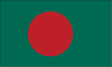
Flag description
green field with a large red disk shifted slightly to the hoist side of center; the red disk represents the rising sun and the sacrifice to achieve independence; the green field symbolizes the lush vegetation of Bangladesh
Government type
parliamentary democracy
Independence
16 December 1971 (from West Pakistan); note - 26 March 1971 is the date of independence from West Pakistan, 16 December 1971 is known as Victory Day and commemorates the official creation of the state of Bangladesh
International organization participation
ADB, ARF, BIMSTEC, C, CICA (observer), CP, D-8, FAO, G-77, IAEA, IBRD, ICAO, ICC, ICCt, ICRM, IDA, IDB, IFAD, IFC, IFRCS, IHO, ILO, IMF, IMO, IMSO, Interpol, IOC, IOM, IPU, ISO, ITSO, ITU, ITUC, MIGA, MINURSO, MONUSCO, NAM, OIC, OPCW, SAARC, SACEP, UN, UNAMID, UNCTAD, UNESCO, UNHCR, UNIDO, UNIFIL, UNMIL, UNMIS, UNMIT, UNOCI, UNWTO, UPU, WCO, WFTU, WHO, WIPO, WMO, WTO
Judicial branch
Supreme Court (the chief justices and other judges are appointed by the president)
Legal system
based on English common law; has not accepted compulsory ICJ jurisdiction
Legislative branch
- unicameral National Parliament or Jatiya Sangsad; 300 seats elected by popular vote from single territorial constituencies; members serve five-year terms
- election results
- percent of vote by party - AL 49%, BNP 33.2%, JP 7%, JIB 4.6%, other 6.2%; seats by party - AL 230, BNP 30, JP 27, JIB 2, other 11
- elections
- last held on 29 December 2008 (next to be held in 2013)
National anthem
- lyrics/music
- Rabindranath TAGORE note: adopted 1971; Rabindranath TAGORE, a Nobel laureate, also wrote India's national anthem
- name
- "Amar Shonar Bangla" (My Golden Bengal)
National holiday
Independence Day, 26 March (1971); note - 26 March 1971 is the date of independence from West Pakistan, 16 December 1971 is Victory Day and commemorates the official creation of the state of Bangladesh
Political parties and leaders
Awami League or AL [Sheikh HASINA]; Bangladesh Communist Party or BCP [Manjurul A. KHAN]; Bangladesh Nationalist Party or BNP [Khaleda ZIA]; Bikalpa Dhara Bangladesh or BDB [Badrudozza CHOWDHURY]; Islami Oikya Jote or IOJ [multiple leaders]; Jamaat-e-Islami Bangladesh or JIB [Matiur Rahman NIZAMI]; Jatiya Party or JP (Ershad faction) [Hussain Mohammad ERSHAD]; Liberal Democratic Party or LDP [Oli AHMED]
Political pressure groups and leaders
- Advocacy to End Gender-based Violence through the MoWCA (Ministry of Women's and Children's Affairs)
- other
- environmentalists; Islamist groups; religious leaders; teachers; union leaders
Suffrage
18 years of age; universal
Economy
Agriculture - products
rice, jute, tea, wheat, sugarcane, potatoes, tobacco, pulses, oilseeds, spices, fruit; beef, milk, poultry
Central bank discount rate
5% (31 October 2010) 5% (31 December 2008)
Commercial bank prime lending rate
14.6% (31 December 2009 est.) 16.38% (31 December 2008 est.)
Current account balance
$3.734 billion (2010) $2.416 billion (2009)
Debt - external
$24.46 billion (31 December 2010 est.) $24.22 billion (31 December 2009 est.)
Distribution of family income - Gini index
33.2 (2005) 33.6 (1996)
Economy - overview
The economy has grown 5-6% per year since 1996 despite political instability, poor infrastructure, corruption, insufficient power supplies, and slow implementation of economic reforms. Bangladesh remains a poor, overpopulated, and inefficiently-governed nation. Although more than half of GDP is generated through the service sector, 45% of Bangladeshis are employed in the agriculture sector, with rice as the single-most-important product. Bangladesh's growth was resilient during the 2008-09 global financial crisis and recession. Garment exports, totaling $12.3 billion in FY09 and remittances from overseas Bangladeshis totaling $9.7 billion in FY09 accounted for almost 25% of GDP.
Electricity - consumption
23.94 billion kWh (2007 est.)
Electricity - exports
0 kWh (2008 est.)
Electricity - imports
0 kWh (2008 est.)
Electricity - production
25.62 billion kWh (2007 est.)
Exchange rates
taka (BDT) per US dollar - 70.59 (2010), 69.039 (2009), 68.554 (2008), 69.893 (2007), 69.031 (2006)
Exports
$16.24 billion (2010) $15.58 billion (2009)
Exports - commodities
garments, frozen fish and seafood, jute and jute goods, leather
Exports - partners
US 22.5%, Germany 14.2%, UK 9.6%, France 7%, Netherlands 6.4% (2009)
GDP - composition by sector
- agriculture
- 18.4%
- industry
- 28.7%
- services
- 52.9% (2010 est.)
GDP - per capita (PPP)
$1,700 (2010 est.) $1,600 (2009 est.) $1,500 (2008 est.) note: data are in 2010 US dollars
GDP - real growth rate
6% (2010 est.) 5.7% (2009 est.) 6% (2008 est.)
GDP (official exchange rate)
$105.4 billion (2010 est.)
GDP (purchasing power parity)
$259.3 billion (2010 est.) $244.6 billion (2009 est.) $231.4 billion (2008 est.) note: data are in 2010 US dollars
Household income or consumption by percentage share
lowest 10%: 8.8% highest 10%: 26.6% (2008 est.)
Imports
$21.34 billion (2010) $20.3 billion (2009)
Imports - commodities
machinery and equipment, chemicals, iron and steel, textiles, foodstuffs, petroleum products, cement
Imports - partners
China 16.16%, India 12.61%, Singapore 7.55%, Japan 4.63%, Malaysia 4.46% (2009)
Industrial production growth rate
6.4% (2010 est.)
Industries
cotton textiles, jute, garments, tea processing, paper newsprint, cement, chemical fertilizer, light engineering, sugar
Inflation rate (consumer prices)
8.1% (2010 est.) 5.4% (2009 est.)
Investment (gross fixed)
23.8% of GDP (2010 est.)
Labor force
73.87 million note: extensive export of labor to Saudi Arabia, Kuwait, UAE, Oman, Qatar, and Malaysia; workers' remittances estimated at $10.9 billion in 2009-10 (2010 est.)
Labor force - by occupation
- agriculture
- 45%
- industry
- 30%
- services
- 25% (2008)
Market value of publicly traded shares
$7.068 billion (31 December 2009) $6.671 billion (31 December 2008) $6.793 billion (31 December 2007)
Natural gas - consumption
19.7 billion cu m (2008 est.)
Natural gas - exports
0 cu m (2008 est.)
Natural gas - imports
0 cu m (2008 est.)
Natural gas - production
19.7 billion cu m (2008 est.)
Natural gas - proved reserves
195.4 billion cu m (1 January 2010 est.)
Oil - consumption
96,000 bbl/day (2009 est.)
Oil - exports
2,612 bbl/day (2007 est.)
Oil - imports
87,660 bbl/day (2007 est.)
Oil - production
5,733 bbl/day (2009 est.)
Oil - proved reserves
28 million bbl (1 January 2010 est.)
Population below poverty line
36.3% (2008 est.)
Public debt
39.3% of GDP (2010 est.) 39.7% of GDP (2009 est.)
Reserves of foreign exchange and gold
$10.79 billion (31 December 2010 est.) $10.34 billion (31 December 2009 est.)
Stock of broad money
$57.21 billion (31 December 2010 est.) $63.03 billion (31 December 2009)
Stock of direct foreign investment - abroad
$82 million (31 December 2010 est.) $81 million (31 December 2009 est.)
Stock of direct foreign investment - at home
$6.72 billion (31 December 2010 est.) $5.617 billion (31 December 2009 est.)
Stock of domestic credit
$62.2 billion (31 December 2010 est.) $53.77 billion (31 December 2009 est.)
Stock of narrow money
$13.98 billion (31 December 2010 est) $10.92 billion (31 December 2009 est)
Unemployment rate
5.1% (2010 est.) 5.1% (2009 est.) note: about 40% of the population is underemployed; many participants in the labor force work only a few hours a week, at low wages
Communications
Broadcast media
state-owned broadcaster (BTV) operates 1 terrestrial TV station, 3 radio networks, and about 10 local stations; 8 private satellite TV stations and 3 private radio stations also broadcasting; foreign satellite TV stations are gaining audience share in the large cities; several international radio broadcasters are available (2007)
Internet country code
.bd
Internet hosts
68,224 (2010)
Internet users
617,300 (2009)
Telephone system
- domestic
- fixed-line teledensity remains only about 1 per 100 persons; mobile-cellular telephone subscribership has been increasing rapidly and now exceeds 30 telephones per 100 persons
- general assessment
- inadequate for a modern country; introducing digital systems; trunk systems include VHF and UHF microwave radio relay links, and some fiber-optic cable in cities
- international
- country code - 880; landing point for the SEA-ME-WE-4 fiber-optic submarine cable system that provides links to Europe, the Middle East, and Asia; satellite earth stations - 6; international radiotelephone communications and landline service to neighboring countries (2009)
Telephones - main lines in use
1.522 million (2009)
Telephones - mobile cellular
50.4 million (2009)
Transportation
Airports
17 (2010)
Airports - with paved runways
- total
- 15 over 3,047 m: 2 2,438 to 3,047 m: 2 1,524 to 2,437 m: 6 914 to 1,523 m: 1 under 914 m: 4 (2010)
Airports - with unpaved runways
- total
- 2 1,524 to 2,437 m: 1 under 914 m: 1 (2010)
Merchant marine
- by type
- bulk carrier 16, cargo 25, container 5, petroleum tanker 4
- foreign-owned
- 4 (China 1, Singapore 3)
- registered in other countries
- 9 (Comoros 1, Malta 1, Panama 3, Saint Vincent and the Grenadines 1, Sierra Leone 1, Singapore 2) (2010)
- total
- 50
Pipelines
gas 2,597 km (2009)
Ports and terminals
Chittagong, Mongla Port
Railways
- broad gauge
- 946 km 1.676-m gauge
- narrow gauge
- 1,822 km 1.000-m gauge (2008)
- total
- 2,768 km
Roadways
- paved
- 22,726 km
- total
- 239,226 km
- unpaved
- 216,500 km (2003)
Transportation - note
the International Maritime Bureau reports the territorial waters of Bangladesh as high risk for armed robbery against ships; numerous commercial vessels have been attacked both at anchor and while underway; crews have been robbed and stores or cargoes stolen
Waterways
8,370 km note: includes up to 3,060 km main cargo routes; network reduced to 5,200 km in dry season (2007)
Military and Security
Manpower available for military service
males age 16-49: 36,560,110 (2010 est.)
Manpower fit for military service
males age 16-49: 25,310,750 females age 16-49: 32,154,153 (2010 est.)
Manpower reaching militarily significant age annually
- female
- 1,676,137 (2010 est.)
- male
- 1,550,385
Military branches
- Bangladesh Defense Force
- Bangladesh Army (Sena Bahini), Bangladesh Navy (Noh Bahini, BN), Bangladesh Air Force (Biman Bahini, BAF) (2010)
Military expenditures
1.3% of GDP (2009)
Military service age and obligation
16 years of age for voluntary enlisted military service (Air Force); 17 years of age (Army and Navy); conscription is by law possible in times of emergency, but has never been implemented (2010)
Transnational Issues
Disputes - international
discussions with India remain stalled to delimit a small section of river boundary, exchange territory for 51 small Bangladeshi exclaves in India and 111 small Indian exclaves in Bangladesh, allocate divided villages, and stop illegal cross-border trade, migration, violence, and transit of terrorists through the porous border; Bangladesh protests India's fencing and walling off high-traffic sections of the porous boundary; a joint Bangladesh-India boundary commission resurveyed and reconstructed 92 missing pillars in 2007; after 21 years, Bangladesh in January 2008 resumed talks with Burma on delimiting a maritime boundary
Illicit drugs
transit country for illegal drugs produced in neighboring countries page last updated on January 20, 2011 ======================================================================
Refugees and internally displaced persons
- IDPs
- 65,000 (land conflicts, religious persecution) (2007)
- refugees (country of origin)
- 26,268 (Burma)
Trafficking in persons
- current situation
- Bangladesh is a source and transit country for men, women, and children trafficked for the purposes of forced labor and commercial sexual exploitation; a significant share of Bangladesh's trafficking victims are men recruited for work overseas with fraudulent employment offers who are subsequently exploited under conditions of forced labor or debt bondage; children are trafficked within Bangladesh for commercial sexual exploitation, bonded labor, and forced labor; women and children from Bangladesh are also trafficked to India and Pakistan for sexual exploitation
- tier rating
- Bangladesh is placed on Tier 2 Watch List because it does not fully comply with the minimum standards for the elimination of trafficking; however, it is making significant efforts to do so, including some progress in addressing sex trafficking; the government did not demonstrate sufficient progress in criminally prosecuting and convicting labor trafficking offenders, particularly those responsible for the recruitment of Bangladeshi workers for the purpose of labor trafficking (2009)