2013 Edition
CIA World Factbook 2013 Archive (HTML)
Introduction
Background
Azerbaijan - a nation with a majority-Turkic and majority-Shia Muslim population - was briefly independent (from 1918 to 1920) following the collapse of the Russian Empire; it was subsequently incorporated into the Soviet Union for seven decades. Azerbaijan has yet to resolve its conflict with Armenia over Nagorno-Karabakh, a primarily Armenian-populated region that Moscow recognized in 1923 as an autonomous region within Soviet Azerbaijan after Armenia and Azerbaijan disputed the status of the territory. Armenia and Azerbaijan began fighting over the area in 1988; the struggle escalated after both countries attained independence from the Soviet Union in 1991. By May 1994, when a cease-fire took hold, ethnic Armenian forces held not only Nagorno-Karabakh but also seven surrounding provinces in the territory of Azerbaijan. The OSCE Minsk Group, co-chaired by the United States, France, and Russia, is the framework established to mediate a peaceful resolution of the conflict. Corruption in the country is widespread, and the government, which eliminated presidential term limits in a 2009 referendum, has been accused of authoritarianism. Although the poverty rate has been reduced and infrastructure investment has increased substantially in recent years due to revenue from oil and gas production, reforms have not adequately addressed weaknesses in most government institutions, particularly in the education and health sectors. In January 2012, Azerbaijan assumed a nonpermanent seat on the UN Security Council for the 2012-13 term.
Geography
Area
- 86,600 sq km 82,629 sq km 3,971 sq km includes the exclave of Naxcivan Autonomous Republic and the Nagorno-Karabakh region; the region's autonomy was abolished by Azerbaijani Supreme Soviet on 26 November 1991
- total
- 86,600 sq km
- water
- 3,971 sq km
Area - comparative
slightly smaller than Maine
Climate
dry, semiarid steppe
Coastline
0 km (landlocked); note - Azerbaijan borders the Caspian Sea (713 km)
Elevation extremes
- Caspian Sea -28 m Bazarduzu Dagi 4,485 m
- highest point
- Bazarduzu Dagi 4,485 m
- lowest point
- Caspian Sea -28 m
Environment - current issues
local scientists consider the Abseron Yasaqligi (Apsheron Peninsula) (including Baku and Sumqayit) and the Caspian Sea to be the ecologically most devastated area in the world because of severe air, soil, and water pollution; soil pollution results from oil spills, from the use of DDT pesticide, and from toxic defoliants used in the production of cotton
Environment - international agreements
- Air Pollution, Biodiversity, Climate Change, Climate Change-Kyoto Protocol, Desertification, Endangered Species, Hazardous Wastes, Marine Dumping, Ozone Layer Protection, Ship Pollution, Wetlands none of the selected agreements
- party to
- Air Pollution, Biodiversity, Climate Change, Climate Change-Kyoto Protocol, Desertification, Endangered Species, Hazardous Wastes, Marine Dumping, Ozone Layer Protection, Ship Pollution, Wetlands
- signed, but not ratified
- none of the selected agreements
Freshwater withdrawal (domestic/industrial/agricultural)
- 12.21 cu km/yr (4%/18%/78%) 1,384 cu m/yr (2010)
- per capita
- 1,384 cu m/yr (2010)
- total
- 12.21 cu km/yr (4%/18%/78%)
Geographic coordinates
40 30 N, 47 30 E
Geography - note
both the main area of the country and the Naxcivan exclave are landlocked
Irrigated land
14,250 sq km (2010)
Land boundaries
- 2,013 km Armenia (with Azerbaijan-proper) 566 km, Armenia (with Azerbaijan-Naxcivan exclave) 221 km, Georgia 322 km, Iran (with Azerbaijan-proper) 432 km, Iran (with Azerbaijan-Naxcivan exclave) 179 km, Russia 284 km, Turkey 9 km
- border countries
- Armenia (with Azerbaijan-proper) 566 km, Armenia (with Azerbaijan-Naxcivan exclave) 221 km, Georgia 322 km, Iran (with Azerbaijan-proper) 432 km, Iran (with Azerbaijan-Naxcivan exclave) 179 km, Russia 284 km, Turkey 9 km
- total
- 2,013 km
Land use
- 21.78% 2.62% 75.6% (2011)
- arable land
- 21.78%
- other
- 75.6% (2011)
- permanent crops
- 2.62%
Location
Southwestern Asia, bordering the Caspian Sea, between Iran and Russia, with a small European portion north of the Caucasus range
Map references
Middle East
Maritime claims
none (landlocked)
Natural hazards
droughts
Natural resources
petroleum, natural gas, iron ore, nonferrous metals, bauxite
Terrain
large, flat Kur-Araz Ovaligi (Kura-Araks Lowland, much of it below sea level) with Great Caucasus Mountains to the north, Qarabag Yaylasi (Karabakh Upland) in west; Baku lies on Abseron Yasaqligi (Apsheron Peninsula) that juts into Caspian Sea
Total renewable water resources
34.68 cu km (2011)
People and Society
Age structure
- 22.6% (male 1,164,189/female 1,006,483) 18.3% (male 905,277/female 849,642) 44.9% (male 2,092,945/female 2,209,623) 7.9% (male 350,068/female 410,765) 6.3% (male 229,244/female 371,923) (2013 est.)
- 0-14 years
- 22.6% (male 1,164,189/female 1,006,483)
- 15-24 years
- 18.3% (male 905,277/female 849,642)
- 25-54 years
- 44.9% (male 2,092,945/female 2,209,623)
- 55-64 years
- 7.9% (male 350,068/female 410,765)
- 65 years and over
- 6.3% (male 229,244/female 371,923) (2013 est.)
Birth rate
17.17 births/1,000 population (2013 est.)
Child labor - children ages 5-14
- 106,626 7 % (2005 est.)
- percentage
- 7 % (2005 est.)
- total number
- 106,626
Children under the age of 5 years underweight
8.4% (2006)
Contraceptive prevalence rate
51.1% (2006)
Death rate
7.11 deaths/1,000 population (2013 est.)
Dependency ratios
- 38.5 % 30.8 % 7.8 % 12.9 (2013)
- elderly dependency ratio
- 7.8 %
- potential support ratio
- 12.9 (2013)
- total dependency ratio
- 38.5 %
- youth dependency ratio
- 30.8 %
Drinking water source
- urban: 88% of population rural: 71% of population total: 80% of population urban: 12% of population rural: 29% of population total: 20% of population (2010 est.)
- rural
- 29% of population
- total
- 20% of population (2010 est.)
- urban
- 12% of population
Education expenditures
2.8% of GDP (2010)
Ethnic groups
Azeri 90.6%, Dagestani 2.2%, Russian 1.8%, Armenian 1.5%, other 3.9% (1999 census) almost all Armenians live in the separatist Nagorno-Karabakh region
Health expenditures
5.2% of GDP (2011)
HIV/AIDS - adult prevalence rate
0.1% (2009 est.)
HIV/AIDS - deaths
fewer than 200 (2009 est.)
HIV/AIDS - people living with HIV/AIDS
3,600 (2009 est.)
Hospital bed density
4.6 beds/1,000 population (2011)
Infant mortality rate
- 27.69 deaths/1,000 live births 28.46 deaths/1,000 live births 26.82 deaths/1,000 live births (2013 est.)
- female
- 26.82 deaths/1,000 live births (2013 est.)
- total
- 27.69 deaths/1,000 live births
Languages
Azerbaijani (Azeri) (official) 90.3%, Lezgi 2.2%, Russian 1.8%, Armenian 1.5%, other 3.3%, unspecified 1% (1999 census)
Life expectancy at birth
- 71.61 years 68.65 years 74.97 years (2013 est.)
- female
- 74.97 years (2013 est.)
- total population
- 71.61 years
Literacy
- age 15 and over can read and write 99.8% 99.9% 99.7% (2010 census)
- definition
- age 15 and over can read and write
- female
- 99.7% (2010 census)
- male
- 99.9%
- total population
- 99.8%
Major urban areas - population
BAKU (capital) 2.123 million (2011)
Maternal mortality rate
43 deaths/100,000 live births (2010)
Median age
- 29.8 years 28.2 years 31.6 years (2013 est.)
- female
- 31.6 years (2013 est.)
- male
- 28.2 years
- total
- 29.8 years
Mother's mean age at first birth
24.4 (2010 est.)
Nationality
- Azerbaijani(s) Azerbaijani
- adjective
- Azerbaijani
- noun
- Azerbaijani(s)
Net migration rate
0 migrant(s)/1,000 population (2013 est.)
Obesity - adult prevalence rate
23.8% (2008)
Physicians density
3.38 physicians/1,000 population (2011)
Population
9,590,159 (July 2013 est.)
Population growth rate
1.01% (2013 est.)
Religions
Muslim 93.4%, Russian Orthodox 2.5%, Armenian Orthodox 2.3%, other 1.8% (1995 est.) religious affiliation is still nominal in Azerbaijan; percentages for actual practicing adherents are much lower
Sanitation facility access
- urban: 86% of population rural: 78% of population total: 82% of population urban: 14% of population rural: 22% of population total: 18% of population (2010 est.)
- rural
- 22% of population
- total
- 18% of population (2010 est.)
- urban
- 14% of population
School life expectancy (primary to tertiary education)
- 12 years 12 years 12 years (2011)
- female
- 12 years (2011)
- male
- 12 years
- total
- 12 years
Sex ratio
- 1.13 male(s)/female 1.16 male(s)/female 1.06 male(s)/female 0.94 male(s)/female 0.85 male(s)/female 0.62 male(s)/female 0.98 male(s)/female (2013 est.)
- 0-14 years
- 1.16 male(s)/female
- 15-24 years
- 1.06 male(s)/female
- 25-54 years
- 0.94 male(s)/female
- 55-64 years
- 0.85 male(s)/female
- 65 years and over
- 0.62 male(s)/female
- at birth
- 1.13 male(s)/female
- total population
- 0.98 male(s)/female (2013 est.)
Total fertility rate
1.92 children born/woman (2013 est.)
Unemployment, youth ages 15-24
- 14.7% 14.2% 15.2% (2011)
- female
- 15.2% (2011)
- total
- 14.7%
Urbanization
- 53.6% of total population (2011) 1.64% annual rate of change (2010-15 est.)
- rate of urbanization
- 1.64% annual rate of change (2010-15 est.)
- urban population
- 53.6% of total population (2011)
Government
Administrative divisions
- 66 rayons (rayonlar; rayon - singular), 11 cities (saharlar; sahar - singular); Abseron, Agcabadi, Agdam, Agdas, Agstafa, Agsu, Astara, Babak, Balakan, Barda, Beylaqan, Bilasuvar, Cabrayil, Calilabad, Culfa, Daskasan, Fuzuli, Gadabay, Goranboy, Goycay, Goygol, Haciqabul, Imisli, Ismayilli, Kalbacar, Kangarli, Kurdamir, Lacin, Lankaran, Lerik, Masalli, Neftcala, Oguz, Ordubad, Qabala, Qax, Qazax, Qobustan, Quba, Qubadli, Qusar, Saatli, Sabirabad, Sabran, Sadarak, Sahbuz, Saki, Salyan, Samaxi, Samkir, Samux, Sarur, Siyazan, Susa, Tartar, Tovuz, Ucar, Xacmaz, Xizi, Xocali, Xocavand, Yardimli, Yevlax, Zangilan, Zaqatala, Zardab Baku, Ganca, Lankaran, Mingacevir, Naftalan, Naxcivan (Nakhichevan), Saki, Sirvan, Sumqayit, Xankandi, Yevlax
- cities
- Baku, Ganca, Lankaran, Mingacevir, Naftalan, Naxcivan (Nakhichevan), Saki, Sirvan, Sumqayit, Xankandi, Yevlax
- rayons
- Abseron, Agcabadi, Agdam, Agdas, Agstafa, Agsu, Astara, Babak, Balakan, Barda, Beylaqan, Bilasuvar, Cabrayil, Calilabad, Culfa, Daskasan, Fuzuli, Gadabay, Goranboy, Goycay, Goygol, Haciqabul, Imisli, Ismayilli, Kalbacar, Kangarli, Kurdamir, Lacin, Lankaran, Lerik, Masalli, Neftcala, Oguz, Ordubad, Qabala, Qax, Qazax, Qobustan, Quba, Qubadli, Qusar, Saatli, Sabirabad, Sabran, Sadarak, Sahbuz, Saki, Salyan, Samaxi, Samkir, Samux, Sarur, Siyazan, Susa, Tartar, Tovuz, Ucar, Xacmaz, Xizi, Xocali, Xocavand, Yardimli, Yevlax, Zangilan, Zaqatala, Zardab
Capital
- Baku (Baki, Baky) 40 23 N, 49 52 E UTC+4 (9 hours ahead of Washington, DC during Standard Time) +1hr, begins last Sunday in March; ends last Sunday in October
- daylight saving time
- +1hr, begins last Sunday in March; ends last Sunday in October
- geographic coordinates
- 40 23 N, 49 52 E
- name
- Baku (Baki, Baky)
- time difference
- UTC+4 (9 hours ahead of Washington, DC during Standard Time)
Constitution
several previous; latest adopted 12 November 1995; amended 1996, 2002, 2009 (2009)
Country name
- Republic of Azerbaijan Azerbaijan Azarbaycan Respublikasi Azarbaycan Azerbaijan Soviet Socialist Republic
- conventional long form
- Republic of Azerbaijan
- conventional short form
- Azerbaijan
- former
- Azerbaijan Soviet Socialist Republic
- local long form
- Azarbaycan Respublikasi
- local short form
- Azarbaycan
Diplomatic representation from the US
- Ambassador Richard L. MORNINGSTAR (since 20 July 2012) 83 Azadlig Prospecti, Baku AZ1007 American Embassy Baku, US Department of State, 7050 Baku Place, Washington, DC 20521-7050 [994] (12) 4980-335 through 337 [994] (12) 4656-671
- chief of mission
- Ambassador Richard L. MORNINGSTAR (since 20 July 2012)
- embassy
- 83 Azadlig Prospecti, Baku AZ1007
- FAX
- [994] (12) 4656-671
- mailing address
- American Embassy Baku, US Department of State, 7050 Baku Place, Washington, DC 20521-7050
- telephone
- [994] (12) 4980-335 through 337
Diplomatic representation in the US
- Ambassador Elin SULEYMANOV (since 5 December 2011) 2741 34th Street NW, Washington, DC 20008 [1] (202) 337-3500 [1] (202) 337-5911 Los Angeles
- chancery
- 2741 34th Street NW, Washington, DC 20008
- chief of mission
- Ambassador Elin SULEYMANOV (since 5 December 2011)
- Consulate(s) general
- Los Angeles
- FAX
- [1] (202) 337-5911
- telephone
- [1] (202) 337-3500
Executive branch
- President Ilham ALIYEV (since 31 October 2003) Prime Minister Artur RASIZADE (since 4 November 2003); First Deputy Prime Minister Yaqub EYYUBOV (since June 2006) Council of Ministers appointed by the president and confirmed by the National Assembly president elected by popular vote for a five-year term (eligible for unlimited terms); election last held on 9 October 2013 (next to be held in October 2018); prime minister and first deputy prime minister appointed by the president and confirmed by the National Assembly Ilham ALIYEV reelected president; percent of vote - Ilham ALIYEV 84.5%, Jamil HASANLI 5.5%, other 10% OSCE observers concluded that the election did not meet international standards
- cabinet
- Council of Ministers appointed by the president and confirmed by the National Assembly
- chief of state
- President Ilham ALIYEV (since 31 October 2003)
- election results
- Ilham ALIYEV reelected president; percent of vote - Ilham ALIYEV 84.5%, Jamil HASANLI 5.5%, other 10%
- elections
- president elected by popular vote for a five-year term (eligible for unlimited terms); election last held on 9 October 2013 (next to be held in October 2018); prime minister and first deputy prime minister appointed by the president and confirmed by the National Assembly
- head of government
- Prime Minister Artur RASIZADE (since 4 November 2003); First Deputy Prime Minister Yaqub EYYUBOV (since June 2006)
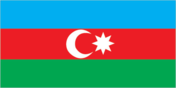
Flag description
three equal horizontal bands of blue (top), red, and green; a crescent and eight-pointed star in white are centered in the red band; the blue band recalls Azerbaijan's Turkic heritage, red stands for modernization and progress, and green refers to Islam; the crescent moon is an Islamic symbol, while the eight-pointed star represents the eight Turkic peoples of the world
Government type
republic
Independence
30 August 1991 (declared from the Soviet Union); 18 October 1991 (adopted by the Supreme Council of Azerbaijan)
International law organization participation
has not submitted an ICJ jurisdiction declaration; non-party state to the ICCt
International organization participation
ADB, BSEC, CD, CE, CICA, CIS, EAPC, EBRD, ECO, EITI (compliant country), FAO, GCTU, GUAM, IAEA, IBRD, ICAO, ICC (NGOs), ICRM, IDA, IDB, IFAD, IFC, IFRCS, ILO, IMF, IMO, Interpol, IOC, IOM, IPU, ISO, ITSO, ITU, ITUC (NGOs), MIGA, NAM, OAS (observer), OIC, OPCW, OSCE, PFP, SELEC (observer), UN, UN Security Council (temporary), UNCTAD, UNESCO, UNHCR, UNIDO, UNWTO, UPU, WCO, WFTU (NGOs), WHO, WIPO, WMO, WTO (observer)
Judicial branch
- Supreme Court (consists of the chairman, deputy chairman, and at least 24 judges in plenum sessions); Constitutional Court (consists of 9 judges) Supreme Court judges nominated by the president and appointed by the Milli Majlis; judge tenure NA; Constitutional Court chairman and deputy chairman appointed by the president; other court judges nominated by the president and appointed by the Milli Majlis to serve single 15-year terms Courts of Appeal (replaced the Economic Court in 2002); district and municipal courts;
- highest court(s)
- Supreme Court (consists of the chairman, deputy chairman, and at least 24 judges in plenum sessions); Constitutional Court (consists of 9 judges)
- judge selection and term of office
- Supreme Court judges nominated by the president and appointed by the Milli Majlis; judge tenure NA; Constitutional Court chairman and deputy chairman appointed by the president; other court judges nominated by the president and appointed by the Milli Majlis to serve single 15-year terms
- subordinate courts
- Courts of Appeal (replaced the Economic Court in 2002); district and municipal courts;
Legal system
civil law system
Legislative branch
- unicameral National Assembly or Milli Mejlis (125 seats; members elected by popular vote to serve five-year terms) last held on 7 November 2010 (next to be held in November 2015) percent of vote by party - YAP 45.8%, CSP 1.6%, Motherland 1.4%, independents 48.2%, other 3.1%; seats by party - YAP 71, CSP 3, Motherland 2, Democratic Reforms 1, Great Creation 1, Hope Party 1, Social Welfare 1, Civil Unity 1, Whole Azerbaijan Popular Front 1, Justice 1, independents 42
- election results
- percent of vote by party - YAP 45.8%, CSP 1.6%, Motherland 1.4%, independents 48.2%, other 3.1%; seats by party - YAP 71, CSP 3, Motherland 2, Democratic Reforms 1, Great Creation 1, Hope Party 1, Social Welfare 1, Civil Unity 1, Whole Azerbaijan Popular Front 1, Justice 1, independents 42
- elections
- last held on 7 November 2010 (next to be held in November 2015)
National anthem
- "Azerbaijan Marsi" (March of Azerbaijan) Ahmed JAVAD/Uzeyir HAJIBEYOV adopted 1992; although originally written in 1919 during a brief period of independence, "Azerbaijan Marsi" did not become the official anthem until after the dissolution of the Soviet Union
- lyrics/music
- Ahmed JAVAD/Uzeyir HAJIBEYOV
- name
- "Azerbaijan Marsi" (March of Azerbaijan)
National holiday
Founding of the Democratic Republic of Azerbaijan, 28 May (1918)
National symbol(s)
flames of fire
Political parties and leaders
Azerbaijan Democratic Party or ADP [Sardar JALALOGLU] Civil Solidarity Party or CSP [Sabir RUSTAMKHANLI] Civil Unity Party [Sabir HACIYEV] Classic People's Front of Azerbaijan [Mirmahmud MIRALI-OGLU] Democratic Reforms Party or PDR [Asim MOLLAZADE] Great Creation Party [Fazil Gazanfaroglu MUSTAFAYEV] Hope (Umid) Party [Iqbal AGAZADE] Justice Party [Ilyas ISMAYILOV] Liberal Party of Azerbaijan [Lala Shovkat HACIYEVA, Avaz TEMIRKHAN] Motherland Party [Fazail AGAMALI] Musavat (Equality) [Isa GAMBAR, chairman] Open Society Party [Sulhaddin AKBAR, Rasul GULIYEV (in exile in the US)] Social Democratic Party of Azerbaijan or SDP [Araz ALIZADE and Ayaz MUTALIBOV (in exile)] Social Welfare Party [Hussein KAZIMLI] United Popular Azerbaijan Front Party or AXCP [Ali KARIMLI] Whole Azerbaijan Popular Front Party [Gudrat HASANGULIYEV] Yeni (New) Azerbaijan Party or YAP [President Ilham ALIYEV] opposition parties regularly factionalize and form new parties
Political pressure groups and leaders
Azerbaijan Public Forum [Eldar NAMAZOV] Karabakh Liberation Organization Forum of Intelligentsia [Rustam IBRAHIMBEYOV] Public Chamber Republican Alternative (REAL) [Ilgar MAMMADOV] NIDA Youth Movement [Turgut GAMBAR, Zaur GURBANLI] Positive Change Youth Movement [Bakhtiyar HAJIYEV] Ireli Youth Movement [Rauf MERDIYEV] Ol! Youth Movement [Vugar SALAMLI]
Suffrage
18 years of age; universal
Economy
Agriculture - products
cotton, grain, rice, grapes, fruit, vegetables, tea, tobacco; cattle, pigs, sheep, goats
Budget
- $22 billion $21.77 billion (2012 est.)
- expenditures
- $21.77 billion (2012 est.)
- revenues
- $22 billion
Budget surplus (+) or deficit (-)
0.3% of GDP (2012 est.)
Central bank discount rate
5% (31 December 2012 est.) 5.25% (31 December 2011 est.) this is the Refinancing Rate, the key policy rate for the National Bank of Azerbaijan
Commercial bank prime lending rate
18.5% (31 December 2012 est.) 19% (31 December 2011 est.)
Current account balance
$14.98 billion (2012 est.) $17.14 billion (2011 est.)
Debt - external
$9.11 billion (31 December 2012 est.) $8.427 billion (31 December 2011 est.)
Distribution of family income - Gini index
33.7 (2008) 36.5 (2001)
Economy - overview
Azerbaijan's high economic growth during 2006-10 was attributable to large and growing oil and gas exports, but some non-export sectors also featured double-digit growth, including construction, banking, and real estate. In 2012, economic growth picked up to 3.8%. Continued production declines in the oil sector were offset by strong growth in the non-oil sector. However, the non-oil sector growth may be driven primarily by government investment, which may not be sustainable if oil production continues to decline. Oil exports through the Baku-Tbilisi-Ceyhan Pipeline, the Baku-Novorossiysk, and the Baku-Supsa pipelines remain the main economic driver, but efforts to boost Azerbaijan's gas production are underway. The eventual completion of the geopolitically important Southern Gas Corridor between Azerbaijan and Europe will open up another, albeit, smaller source of revenue from gas exports. Azerbaijan has made only limited progress on instituting market-based economic reforms. Pervasive public and private sector corruption and structural economic inefficiencies remain a drag on long-term growth, particularly in non-energy sectors. Several other obstacles impede Azerbaijan's economic progress, including the need for stepped up foreign investment in the non-energy sector and the continuing conflict with Armenia over the Nagorno-Karabakh region. Trade with Russia and the other former Soviet republics is declining in importance, while trade is building with Turkey and the nations of Europe. Long-term prospects depend on world oil prices, Azerbaijan's ability to negotiate export routes for its growing gas production, and its ability to use its energy wealth to promote growth and spur employment in non-energy sectors of the economy.
Exchange rates
Azerbaijani manats (AZN) per US dollar - 0.79 (2012 est.) 0.79 (2011 est.) 0.8 (2010 est.) 0.8 (2009) 0.82 (2008)
Exports
$32.63 billion (2012 est.) $34.49 billion (2011 est.)
Exports - commodities
oil and gas 90%, machinery, cotton, foodstuffs
Exports - partners
Italy 27.1%, France 8.1%, Indonesia 6.9%, Germany 5.9%, Israel 5.4%, India 4.2%, US 4.2% (2012)
Fiscal year
calendar year
GDP - composition, by end use
- 39.6% 10.3% 22.5% 0.1% 50.9% -23.5% (2012 est.)
- exports of goods and services
- 50.9%
- government consumption
- 10.3%
- household consumption
- 39.6%
- imports of goods and services
- -23.5%
- investment in fixed capital
- 22.5%
- investment in inventories
- 0.1%
GDP - composition, by sector of origin
- 6.2% 64.3% 29.4% (2012 est.)
- agriculture
- 6.2%
- industry
- 64.3%
- services
- 29.4% (2012 est.)
GDP - per capita (PPP)
$10,400 (2012 est.) $10,300 (2011 est.) $10,400 (2010 est.) data are in 2012 US dollars
GDP - real growth rate
2.2% (2012 est.) 0.1% (2011 est.) 5% (2010 est.)
GDP (official exchange rate)
$67.87 billion (2012 est.)
GDP (purchasing power parity)
$95.73 billion (2012 est.) $93.7 billion (2011 est.) $93.61 billion (2010 est.) data are in 2012 US dollars
Gross national saving
44.4% of GDP (2012 est.) 45.1% of GDP (2011 est.) 46.5% of GDP (2010 est.)
Household income or consumption by percentage share
- 3.4% 27.4% (2008)
- highest 10%
- 27.4% (2008)
- lowest 10%
- 3.4%
Imports
$10.42 billion (2012 est.) $10.17 billion (2011 est.)
Imports - commodities
machinery and equipment, oil products, foodstuffs, metals, chemicals
Imports - partners
Turkey 17.8%, Russia 13.7%, China 7.5%, Germany 6.9%, UK 6.8%, Ukraine 5.5%, US 4.9% (2012)
Industrial production growth rate
-2.3% (2012 est.)
Industries
petroleum and natural gas, petroleum products, oilfield equipment; steel, iron ore; cement; chemicals and petrochemicals; textiles
Inflation rate (consumer prices)
1.1% (2012 est.) 7.8% (2011 est.)
Labor force
4.696 million (2012 est.)
Labor force - by occupation
- 38.3% 12.1% 49.6% (2008)
- agriculture
- 38.3%
- industry
- 12.1%
- services
- 49.6% (2008)
Market value of publicly traded shares
$NA
Population below poverty line
11% (2009 est.)
Public debt
7.8% of GDP (2012 est.) 7.5% of GDP (2011 est.)
Reserves of foreign exchange and gold
$11.28 billion (31 December 2012 est.) $10.27 billion (31 December 2011 est.)
Stock of broad money
$17.68 billion (31 December 2011 est.) $13.19 billion (31 December 2010 est.)
Stock of direct foreign investment - abroad
$7.516 billion (31 December 2012 est.) $6.323 billion (31 December 2011 est.)
Stock of direct foreign investment - at home
$12.35 billion (31 December 2012 est.) $10.35 billion (31 December 2011 est.)
Stock of domestic credit
$17.01 billion (31 December 2012 est.) $12.72 billion (31 December 2011 est.)
Stock of narrow money
$14.15 billion (31 December 2012 est.) $11.22 billion (31 December 2011 est.)
Taxes and other revenues
32.4% of GDP (2012 est.)
Unemployment rate
5.7% (2012 est.) 5.4% (2011 est.)
Energy
Carbon dioxide emissions from consumption of energy
36.52 million Mt (2011 est.)
Crude oil - exports
821,000 bbl/day (2011 est.)
Crude oil - imports
0 bbl/day (2010 est.)
Crude oil - production
931,900 bbl/day (2012 est.)
Crude oil - proved reserves
7 billion bbl (1 January 2013 es)
Electricity - consumption
13.57 billion kWh (2010 est.)
Electricity - exports
462 million kWh (2010 est.)
Electricity - from fossil fuels
84.5% of total installed capacity (2010 est.)
Electricity - from hydroelectric plants
15.4% of total installed capacity (2010 est.)
Electricity - from nuclear fuels
0% of total installed capacity (2010 est.)
Electricity - from other renewable sources
0.1% of total installed capacity (2010 est.)
Electricity - imports
100 million kWh (2010 est.)
Electricity - installed generating capacity
6.392 million kW (2010 est.)
Electricity - production
19.44 billion kWh (2011 est.)
Natural gas - consumption
9.921 billion cu m (2010 est.)
Natural gas - exports
5.55 billion cu m (2011 est.)
Natural gas - imports
250 million cu m (2011 est.)
Natural gas - production
17.86 billion cu m (2011 est.)
Natural gas - proved reserves
991.1 billion cu m (1 January 2013 es)
Refined petroleum products - consumption
168,000 bbl/day (2011 est.)
Refined petroleum products - exports
53,440 bbl/day (2010 est.)
Refined petroleum products - imports
498.6 bbl/day (2010 est.)
Refined petroleum products - production
133,500 bbl/day (2010 est.)
Communications
Broadcast media
3 state-run and 1 public TV channels; 4 domestic commercial TV stations and about 15 regional TV stations; cable TV services are available in Baku; 1 state-run and 1 public radio network operating; a small number of private commercial radio stations broadcasting; local FM relays of Baku commercial stations are available in many localities; local relays of several international broadcasters had been available until late 2008 when their broadcasts were banned from FM frequencies (2010)
Internet country code
.az
Internet hosts
46,856 (2012)
Internet users
2.42 million (2009)
Telephone system
- requires considerable expansion and modernization; fixed-line telephone and a broad range of other telecom services are controlled by a state-owned telecommunications monopoly and growth has been stagnant; more competition exists in the mobile-cellular market with four providers in 2009 teledensity of 17 fixed lines per 100 persons; mobile-cellular teledensity has increased and now exceeds 100 telephones per 100 persons; satellite service connects Baku to a modern switch in its exclave of Naxcivan (Nakhichevan) country code - 994; the Trans-Asia-Europe (TAE) fiber-optic link transits Azerbaijan providing international connectivity to neighboring countries; the old Soviet system of cable and microwave is still serviceable; satellite earth stations - 2 (2011)
- domestic
- teledensity of 17 fixed lines per 100 persons; mobile-cellular teledensity has increased and now exceeds 100 telephones per 100 persons; satellite service connects Baku to a modern switch in its exclave of Naxcivan (Nakhichevan)
- general assessment
- requires considerable expansion and modernization; fixed-line telephone and a broad range of other telecom services are controlled by a state-owned telecommunications monopoly and growth has been stagnant; more competition exists in the mobile-cellular market with four providers in 2009
- international
- country code - 994; the Trans-Asia-Europe (TAE) fiber-optic link transits Azerbaijan providing international connectivity to neighboring countries; the old Soviet system of cable and microwave is still serviceable; satellite earth stations - 2 (2011)
Telephones - main lines in use
1.734 million (2012)
Telephones - mobile cellular
10.125 million (2012)
Transportation
Airports
37 (2013)
Airports - with paved runways
- 3 (2013)
- 1,524 to 2,437 m
- 13
- 2,438 to 3,047 m
- 5
- 914 to 1,523 m
- 4
- over 3,047 m
- 5
- total
- 30
- under 914 m
- 3 (2013)
Airports - with unpaved runways
- 7 (2013)
- total
- 7
Heliports
1 (2012)
Merchant marine
- cargo 27, chemical tanker 1, passenger 2, passenger/cargo 8, petroleum tanker 47, roll on/roll off 3, specialized tanker 2 1 (Turkey 1) 2 (Malta 1, Saint Vincent and the Grenadines 1) (2010)
- foreign-owned
- 1 (Turkey 1)
- registered in other countries
- 2 (Malta 1, Saint Vincent and the Grenadines 1) (2010)
- total
- 90
Pipelines
condensate 89 km; gas 3,890 km; oil 2,446 km (2013)
Ports and terminals
- Baku (Baki) located on the Caspian Sea
- major seaport(s)
- Baku (Baki) located on the Caspian Sea
Railways
- 2,918 km 2,918 km 1.520-m gauge (1,278 km electrified) (2009)
- total
- 2,918 km
Roadways
- 52,942 km 26,789 km 26,153 km (2006)
- total
- 52,942 km
- unpaved
- 26,153 km (2006)
Military and Security
Manpower available for military service
- 2,354,249 2,334,632 (2010 est.)
- females age 16-49
- 2,334,632 (2010 est.)
- males age 16-49
- 2,354,249
Manpower fit for military service
- 1,773,993 1,964,012 (2010 est.)
- females age 16-49
- 1,964,012 (2010 est.)
- males age 16-49
- 1,773,993
Manpower reaching militarily significant age annually
- 76,923 71,024 (2010 est.)
- female
- 71,024 (2010 est.)
- male
- 76,923
Military branches
Army, Navy, Air, and Air Defense Forces (2010)
Military expenditures
2.6% of GDP (2005 est.)
Military service age and obligation
men between 18 and 35 are liable for military service; length of service is 18 months and 12 months for university graduates; 17 years of age for voluntary service; 17 year olds are considered to be on active service at cadet military schools (2012)
Transnational Issues
Disputes - international
Azerbaijan, Kazakhstan, and Russia ratified the Caspian seabed delimitation treaties based on equidistance, while Iran continues to insist on a one-fifth slice of the sea; the dispute over the break-away Nagorno-Karabakh region and the Armenian military occupation of surrounding lands in Azerbaijan remains the primary focus of regional instability; residents have evacuated the former Soviet-era small ethnic enclaves in Armenia and Azerbaijan; local border forces struggle to control the illegal transit of goods and people across the porous, undemarcated Armenian, Azerbaijani, and Georgian borders; bilateral talks continue with Turkmenistan on dividing the seabed and contested oilfields in the middle of the Caspian
Illicit drugs
limited illicit cultivation of cannabis and opium poppy, mostly for CIS consumption; small government eradication program; transit point for Southwest Asian opiates bound for Russia and to a lesser extent the rest of Europe
Refugees and internally displaced persons
- 600,000 (conflict with Armenia over Nagorno-Karabakh) (2013) 3,585 (2012)
- IDPs
- 600,000 (conflict with Armenia over Nagorno-Karabakh) (2013)
- stateless persons
- 3,585 (2012)