2002 Edition
CIA World Factbook 2002 (Project Gutenberg)
Introduction
Background
Australia became a commonwealth of the British Empire in 1901. It was able to take advantage of its natural resources to rapidly develop its agricultural and manufacturing industries and to make a major contribution to the British effort in World Wars I and II. Long-term concerns include pollution, particularly depletion of the ozone layer, and management and conservation of coastal areas, especially the Great Barrier Reef. A referendum to change Australia's status, from a commonwealth headed by the British monarch to an independent republic, was defeated in 1999.
Geography
Area
total: 7,686,850 sq km water: 68,920 sq km note: includes Lord Howe Island and Macquarie Island land: 7,617,930 sq km
Area - comparative
slightly smaller than the US contiguous 48 states
Coastline
25,760 km
Elevation extremes
lowest point: Lake Eyre -15 m highest point: Mount Kosciuszko 2,229 m
Environment - current issues
soil erosion from overgrazing, industrial development, urbanization, and poor farming practices; soil salinity rising due to the use of poor quality water; desertification; clearing for agricultural purposes threatens the natural habitat of many unique animal and plant species; the Great Barrier Reef off the northeast coast, the largest coral reef in the world, is threatened by increased shipping and its popularity as a tourist site; limited natural fresh water resources
Environment - international agreements
party to: Antarctic-Environmental Protocol, Antarctic-Marine Living Resources, Antarctic Seals, Antarctic Treaty, Biodiversity, Climate Change, Desertification, Endangered Species, Environmental Modification, Hazardous Wastes, Law of the Sea, Marine Dumping, Marine Life Conservation, Nuclear Test Ban, Ozone Layer Protection, Ship Pollution, Tropical Timber 83, Tropical Timber 94, Wetlands, Whaling signed, but not ratified: Climate Change-Kyoto Protocol
Geographic coordinates
27 00 S, 133 00 E
Irrigated land
24,000 sq km (1998 est.)
Land boundaries
0 km
Land use
arable land: 7% permanent crops: 0% other: 93% (1998 est.)
Location
Oceania, continent between the Indian Ocean and the South Pacific Ocean
Map references
Oceania
Maritime claims
12 NM exclusive economic zone: Climate: generally arid to semiarid; temperate in south and east; tropical in north
Natural hazards
cyclones along the coast; severe droughts; forest fires
Natural resources
bauxite, coal, iron ore, copper, tin, silver, uranium, nickel, tungsten, mineral sands, lead, zinc, diamonds, natural gas, petroleum
Terrain
mostly low plateau with deserts; fertile plain in southeast
People and Society
Age structure
0-14 years: 20.4% (male 2,046,052; female 1,949,725) 15-64 years: 67% (male 6,610,840; female 6,480,354) 65 years and over: 12.6% (male 1,078,506; female 1,381,315) (2002 est.)
Birth rate
12.71 births/1,000 population (2002 est.)
Death rate
7.25 deaths/1,000 population (2002 est.)
Ethnic groups
Caucasian 92%, Asian 7%, aboriginal and other 1%
HIV/AIDS - adult prevalence rate
0.15% (1999 est.)
HIV/AIDS - deaths
100 (1999 est.)
HIV/AIDS - people living with HIV/AIDS
14,000 (1999 est.)
Infant mortality rate
4.9 deaths/1,000 live births (2002 est.)
Languages
English, native languages
Life expectancy at birth
total population: 80 years female: 83 years (2002 est.) male: 77.15 years
Literacy
definition: age 15 and over can read and write total population: 100% male: 100% female: 100% (1980 est.)
Nationality
noun: Australian(s) adjective: Australian
Net migration rate
4.12 migrant(s)/1,000 population (2002 est.)
Population
19,546,792 (July 2002 est.)
Population growth rate
0.96% (2002 est.)
Religions
Anglican 26.1%, Roman Catholic 26%, other Christian 24.3%, non-Christian 11%, other 12.6%
Sex ratio
at birth: 1.05 male(s)/female under 15 years: 1.05 male(s)/female 15-64 years: 1.02 male(s)/female 65 years and over: 0.78 male(s)/female total population: 0.99 male(s)/female (2002 est.)
Total fertility rate
1.77 children born/woman (2002 est.)
Government
Administrative divisions
6 states and 2 territories*; Australian Capital Territory*, New South Wales, Northern Territory*, Queensland, South Australia, Tasmania, Victoria, Western Australia
Capital
Canberra
Constitution
9 July 1900, effective 1 January 1901
Country name
conventional long form: Commonwealth of Australia conventional short form: Australia
Dependent areas
Ashmore and Cartier Islands, Christmas Island, Cocos (Keeling) Islands, Coral Sea Islands, Heard Island and McDonald Islands, Norfolk Island
Diplomatic representation from the US
chief of mission: Ambassador J. Thomas SCHIEFFER embassy: Moonah Place, Yarralumla, Canberra, Australian Capital Territory 2600 mailing address: consulate(s) general: Melbourne, Perth, Sydney
Diplomatic representation in the US
Ambassador Michael J. THAWLEY consulate(s) general: FAX: [1] (202) 797-3168 telephone: [1] (202) 797-3000 chancery: 1601 Massachusetts Avenue NW, Washington, DC 20036
Executive branch
chief of state: Queen ELIZABETH II (since 6 February 1952), represented by Governor General Rt. Rev. Dr. Peter HOLLINGWORTH (since 29 June 2001) head of government: Prime Minister John Winston HOWARD (since 11 March 1996); Deputy Prime Minister John ANDERSON (since 20 July 1999) cabinet: Cabinet Parliament nominates, from among its members, a list of candidates to serve as government ministers; from this list, the governor general makes the final selections for the Cabinet elections: none; the monarch is hereditary; governor general appointed by the monarch; following legislative elections, the leader of the majority party or leader of a majority coalition is usually appointed prime minister by the governor general for a three-year term note: government coalition - Liberal Party and National Party
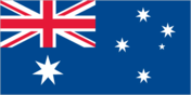
Flag description
blue with the flag of the UK in the upper hoist-side quadrant and a large seven-pointed star in the lower hoist-side quadrant; the remaining half is a representation of the Southern Cross constellation in white with one small five-pointed star and four, larger, seven-pointed stars
Government type
democratic, federal-state system recognizing the British monarch as sovereign
Independence
1 January 1901 (federation of UK colonies)
International organization participation
ANZUS, APEC, ARF (dialogue partner), AsDB, ASEAN (dialogue partner), Australia Group, BIS, C, CCC, CP, EBRD, ESCAP, FAO, IAEA, IBRD, ICAO, ICC, ICFTU, ICRM, IDA, IEA, IFAD, IFC, IFRCS, IHO, ILO, IMF, IMO, Interpol, IOC, IOM, ISO, ITU, NAM (guest), NEA, NSG, OECD, OPCW, PCA, Sparteca, SPC, SPF, UN, UNCTAD, UNESCO, UNHCR, UNMEE, UNTAET, UNTSO, UNU, UPU, WFTU, WHO, WIPO, WMO, WTrO, ZC
Judicial branch
High Court (the chief justice and six other justices are appointed by the governor general)
Legal system
based on English common law; accepts compulsory ICJ jurisdiction, with reservations
Legislative branch
bicameral Federal Parliament consists of the Senate (76 seats - 12 from each of the six states and two from each of the two mainland territories; one-half of the members elected every three years by popular vote to serve six-year terms) and the House of Representatives (150 seats - this is up from 148 seats in 2001 election; members elected by popular vote on the basis of preferential representation to serve three-year terms; no state can have fewer than five representatives) elections: Senate - last held 10 November 2001 (next to be held by November 2004); House of Representatives - last held 10 November 2001 (next to be held by November 2004) election results: Senate - percent of vote by party - NA%; seats by party - Liberal Party-National Party coalition 35, Australian Labor Party 28, Australian Democrats 8, Green Party 2, One Nation Party 1, Country Labor Party 1, independent 1; House of Representatives - percent of vote by party - NA%; seats by party - Liberal Party-National Party coalition 82, Australian Labor Party 65, independent and other 3
National holiday
Australia Day, 26 January (1788)
Political parties and leaders
Australian Democrats [Natasha STOTT-DESPOJA]; Australian Labor Party [Simon CREAN]; Country Labor Party [leader NA]; Green Party [Bob BROWN]; Liberal Party [John Winston HOWARD]; National Party [John ANDERSON]; One Nation Party [leader NA]
Political pressure groups and leaders
Australian Democratic Labor Party (anti-Communist Labor Party splinter group); Australian Monarchist League [leader NA]; Australian Republican Movement [leader NA]
Suffrage
18 years of age; universal and compulsory
Economy
Agriculture - products
wheat, barley, sugarcane, fruits; cattle, sheep, poultry
Budget
revenues: $86.8 billion expenditures: $84.1 billion, including capital expenditures of $NA (FY00/01 est.)
Currency
Australian dollar (AUD)
Currency code
AUD
Debt - external
$168.7 billion (2001 est.)
Distribution of family income - Gini index
35.2 (1994)
Economic aid - donor
ODA, $894 million (FY99/00)
Electricity - consumption
188.489 billion kWh (2000)
Electricity - exports
0 kWh (2000)
Electricity - imports
0 kWh (2000)
Electricity - production
202.676 billion kWh (2000)
Electricity - production by source
fossil fuel: 89.79% hydro: 8.47% other: 1.74% (2000) nuclear: 0%
Exchange rates
Australian dollars per US dollar - 1.9354 (January 2002), 1.9320 (2001), 1.7173 (2000), 1.5497 (1999), 1.5888 (1998), 1.3439 (1997)
Exports
$68.8 billion (2001 est.)
Exports - commodities
coal, gold, meat, wool, alumina, iron ore, wheat, machinery and transport equipment
Exports - partners
Japan 19%, US 9%, South Korea 7%, China 6%, New Zealand 5.8%, Singapore 4% (2001 est.)
Fiscal year
1 July - 30 June
GDP
purchasing power parity - $465.9 billion (2001 est.)
GDP - composition by sector
agriculture: 3% industry: 25% services: 72% (2000 est.)
GDP - per capita
purchasing power parity - $24,000 (2001 est.)
GDP - real growth rate
2.3% (2001 est.)
Household income or consumption by percentage share
lowest 10%: 2% highest 10%: 25.4% (1994)
Imports
$70.2 billion (2001 est.)
Imports - commodities
machinery and transport equipment, computers and office machines, telecommunication equipment and parts; crude oil and petroleum products
Imports - partners
US 20%, Japan 13%, China 7.7%, UK 6%, Germany 5%, South Korea 4%, NZ 4%, Malaysia 3.6% (2001 est.)
Industrial production growth rate
0.4% (2001 est.)
Industries
mining, industrial and transportation equipment, food processing, chemicals, steel
Inflation rate (consumer prices)
4.3% (2001 est.)
Labor force
9.2 million (December 2001)
Labor force - by occupation
services 73%, industry 22%, agriculture 5% (1997 est.)
Population below poverty line
NA%
Unemployment rate
6.7% (2001)
Communications
Internet country code
.au
Internet Service Providers (ISPs)
603 (2001)
Internet users
10.06 million (2001)
Radio broadcast stations
AM 262, FM 345, shortwave 1 (1998)
Radios
25.5 million (1997)
Telephone system
general assessment: excellent domestic and international service domestic: domestic satellite system; much use of radiotelephone in areas of low population density; rapid growth of mobile cellular telephones international: submarine cables to New Zealand, Papua New Guinea, and Indonesia; satellite earth stations - 10 Intelsat (4 Indian Ocean and 6 Pacific Ocean), 2 Inmarsat (Indian and Pacific Ocean regions) (1998)
Telephones - main lines in use
10.05 million (2000)
Telephones - mobile cellular
8.6 million (2000)
Television broadcast stations
104 (1997)
Televisions
10.15 million (1997)
Transportation
Airports
421 (2001)
Airports - with paved runways
11 1,524 to 2,437 m: Airports - with unpaved runways: total: 139 1,524 to 2,437 m: 16 914 to 1,523 m: 111 under 914 m: 12 (2001)
Highways
total: 913,000 km paved: 353,331 km (including 1,363 km of expressways) unpaved: 559,669 km (1996)
Merchant marine
total: 55 ships (1,000 GRT or over) totaling 1,469,362 GRT/1,869,262 DWT ships by type: bulk 26, cargo 5, chemical tanker 4, container 1, liquefied gas 4, passenger 2, petroleum tanker 7, roll on/roll off 6, includes some foreign-owned ships registered here as a flag of convenience: France 2, United Kingdom 2, United States 14 (2002 est.)
Pipelines
crude oil 2,500 km; petroleum products 500 km; natural gas 5,600 km
Ports and harbors
Adelaide, Brisbane, Cairns, Darwin, Devonport (Tasmania), Fremantle, Geelong, Hobart (Tasmania), Launceston (Tasmania), Mackay, Melbourne, Sydney, Townsville
Railways
total: 33,819 km (2,540 km electrified) broad gauge: 3,719 km 1.600-m gauge narrow gauge: 14,506 km 1.067-m gauge standard gauge: 15,422 km 1.435-m gauge dual gauge: 172 km NA gauges (1999 est.)
Waterways
8,368 km (mainly used by small, shallow-draft craft)
Military and Security
Military expenditures - dollar figure
$9.3 billion (FY01/02 est.)
Military expenditures - percent of GDP
2% (FY01/02)
Military manpower - availability
males age 15-49: 5,013,406 (2002 est.)
Military manpower - fit for military service
males age 15-49: 4,321,387 (2002 est.)
Military manpower - military age
17 years of age (2002 est.)
Military manpower - reaching military age annually
males: 142,686 (2002 est.)
Transnational Issues
Disputes - international
Australia-East Timor-Indonesia are working to resolve maritime boundary and sharing of seabed resources in "Timor Gap"; Australia asserts a territorial claim to Antarctica and to its continental shelf
Illicit drugs
Tasmania is one of the world's major suppliers of licit opiate products; government maintains strict controls over areas of opium poppy cultivation and output of poppy straw concentrate This page was last updated on 1 January 2002 Ashmore and Cartier Islands